


-
 3654 Hits
-
 80.49% Score
-
 12 Votes
|
|
Route |
|---|---|
|
|
45.81830°N / 7.02432°E |
|
|
Hiking |
|
|
Spring, Summer, Fall, Winter |
|
|
Half a day |
|
|
F or F+ by Snowshoes or Ski-Mountaineering |
|
|
Note
|
La montagna chiama i suoi figli, ed essi rispondono fedelmente al suo appello… Osvaldo Cardellina, Diario alpinistico, 1964-65 Page texts: @ OsvaldoCardellina "Osva", passed away on May 2, 2022. Page owners: Christian Cardellina e Osvaldo Cardellina. Any updates from September 12, 2022: Antonio Giani, page administrator, friend and climbing companion. Testi della pagina: @ OsvaldoCardellina "Osva", scomparso il 2 maggio 2022. Proprietari pagina: Christian Cardellina e Osvaldo Cardellina. Eventuali aggiornamenti dal 12 settembre 2022: Antonio Giani, amministratore della pagina, amico e compagno di salite. |
Valsapin Touroverview
The Valley of Aosta is a small Region in the size of the entire Alpine Arch, however, has a multitude of places where you can make beautiful and easy hikes. Among these, the Val Sapin, just outside Courmayeur, a place that with its two side valleys of Veny and Ferret in the Southwest to the Northeast concludes the deployment of the valleys, before the Mont Blanc separates Italy from Savoy in France. From the top it flaunts its thirteen Valli and the many vallons, which offer varied opportunities to attend and meet her. In this little work, however, is meant to let you all know if not completely, at least in a partial view from afar to all its major Valleys, proposing a series of views with the primary objective to make you wander nearly 360° across the Valley of Aosta. Almost on the whole, but above all because in the same involve taking direct view of the entire area looking from the West to the East, or from the "Upper Valley" in the direction of "Media-Lower Valley." But, here, the main objective is to give a close look at the impressive chain of Mont Blanc, from the watershed between Val Sapin and the Italian Val Ferret, relaxing in all its grandeur from the Col de la Seigne, before the Aiguille des Glaciers , to that of Ferret, after Mont Dolent and Mont Grapillon. A large balcony, above which appear to precipitate Les Grandes Jorasses, while on the opposite side of the Grande Rochère, hence truly beautiful and bold, somewhat must resize its claims adapting to the role of appearance. Nevertheless we admired the turn even a glance at her, before starting the complete crossing on the watershed that, bypassing the Tête de la Tronche, the Testa Bernarda and the long ridge of Mont de la Saxe, makes us reach Rifugio Giorgio Bertone, above the grassy-rocky promontory overlooking the valley completely, forming the pivot partition between the Valleys Veny Ferret and above the Common Courmayeur. Here eyes are exclusively for the Chain Mont Blanc passing from bloated Jorasses, the tiny Dente del Gigante and Aiguille Noire de Péuterey, which, flirtatious and soaring into the sky, challenge even Her Majesty.
![]()
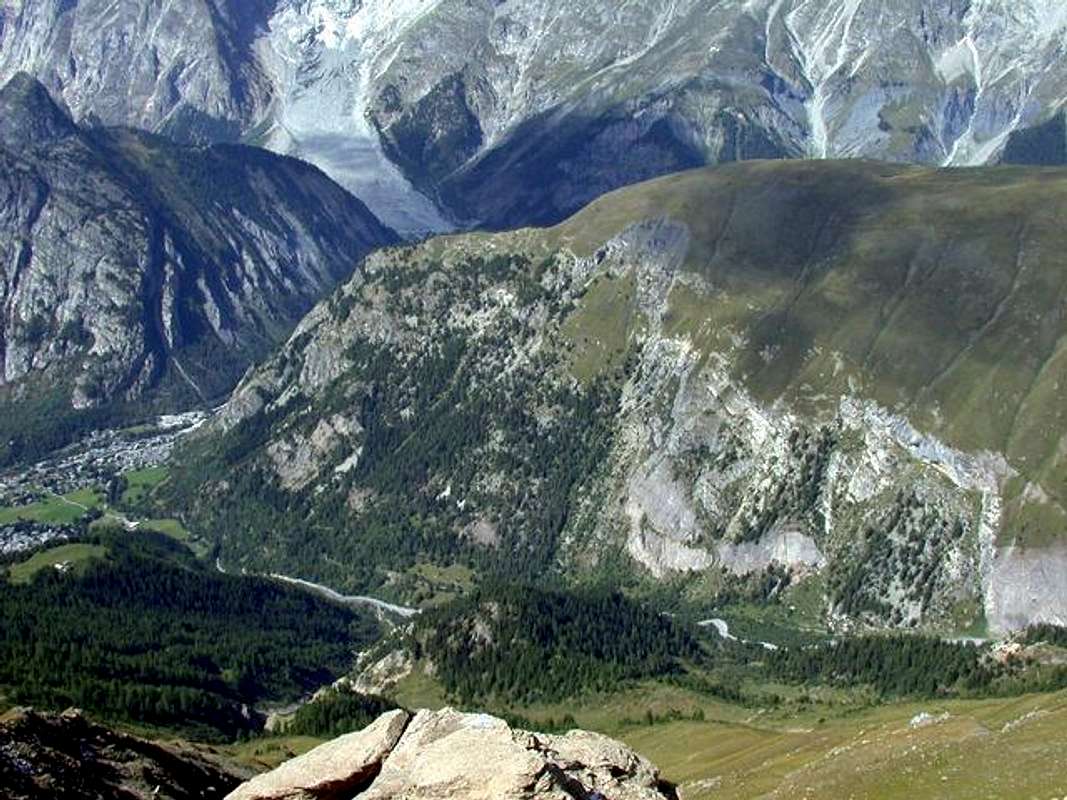
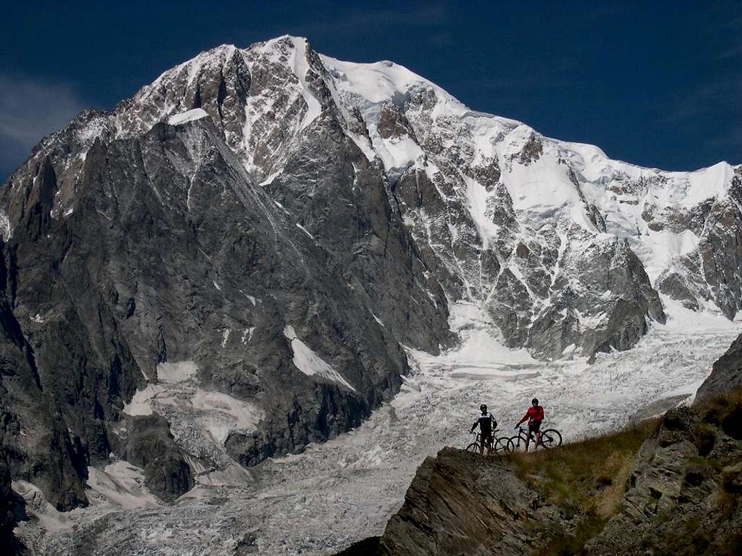
Mont de la Saxe on Val Sapin & above Courmayeur-Resort, by buxlex
![]()
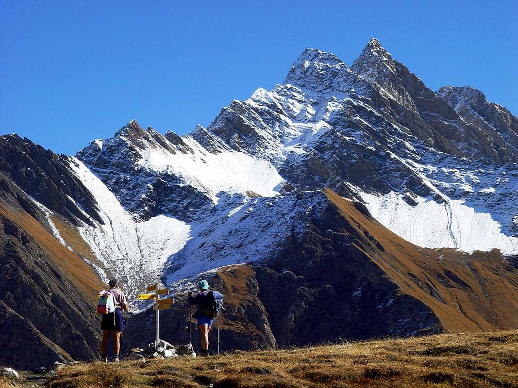
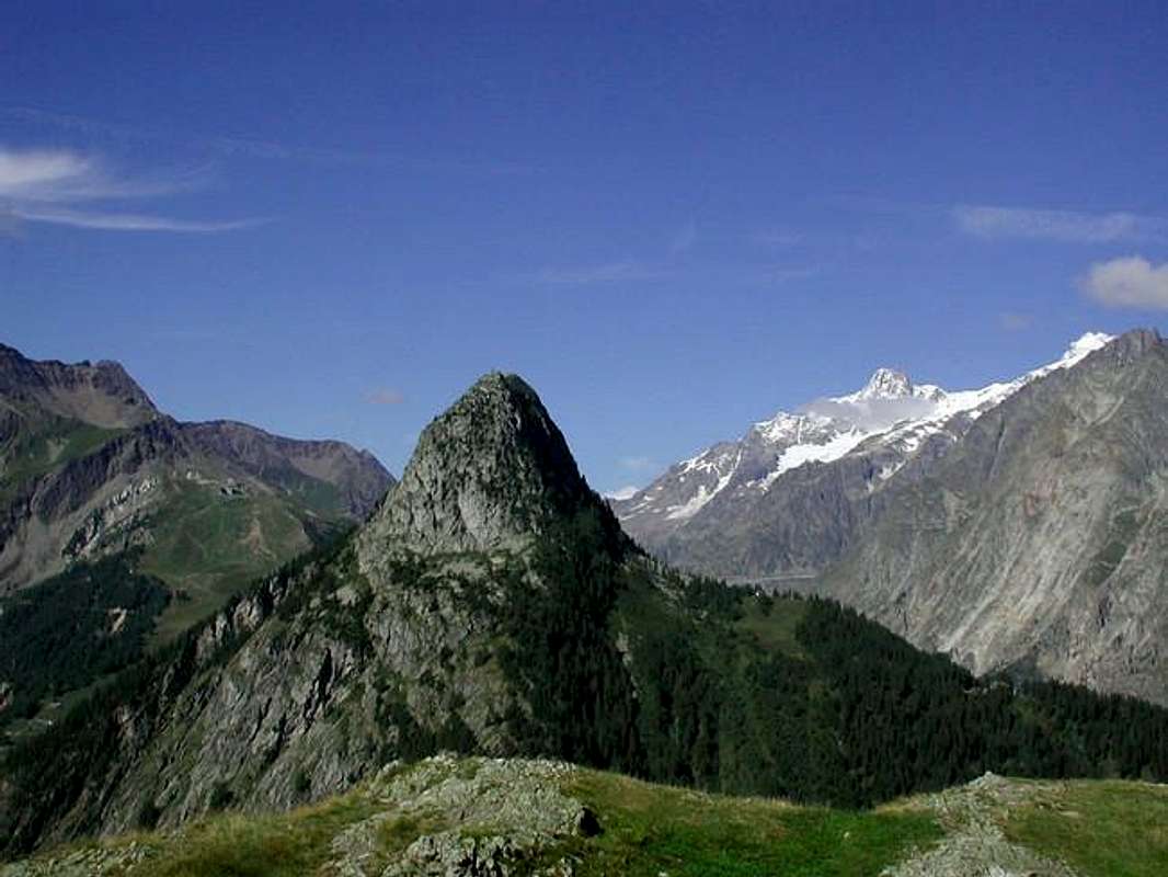
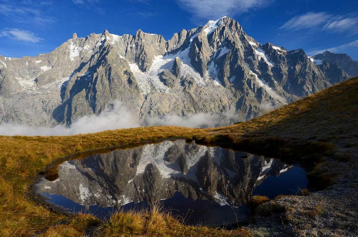
"Admiring the pyramid of Grande Rochère (3.326m) from Sapin Hill (2.435m)", by Emilio Bertona aka emilius
![]()
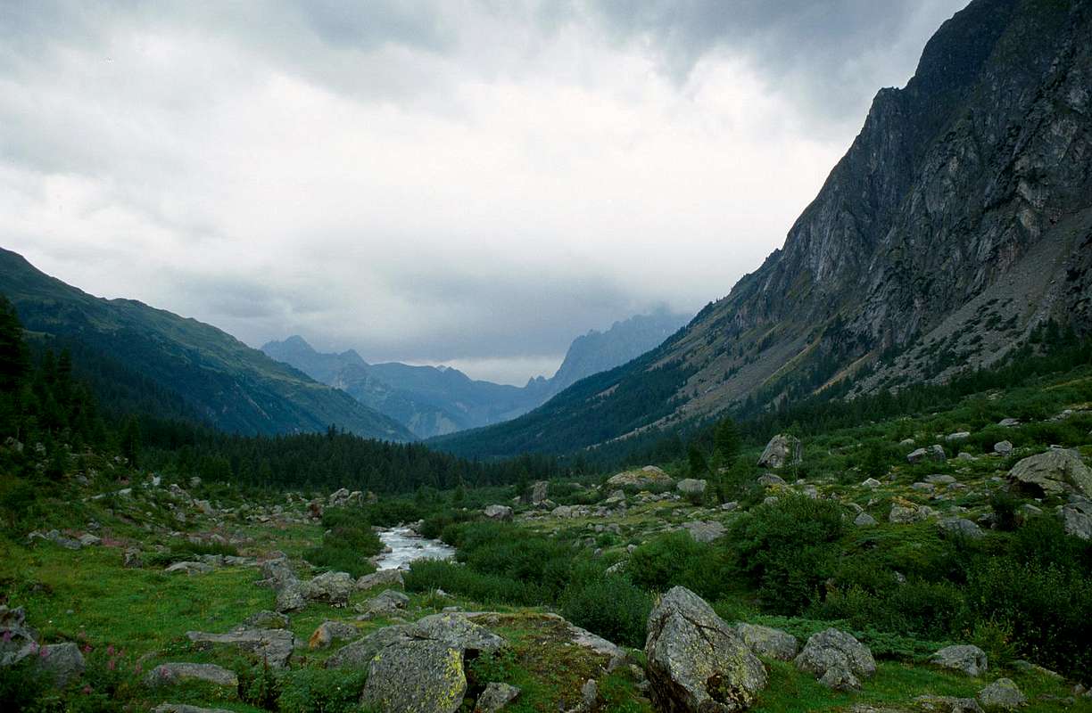
Arriving the storm on Val Veny, by om
![]()
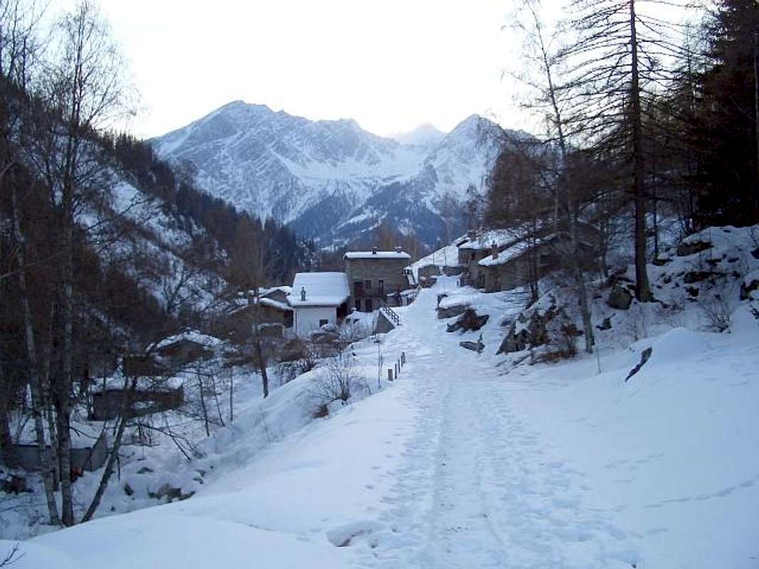
Winter Val Sapin, by signorelli
![]()
By Ferret Hill to entire Valley, by Gabriele Roth
BY PLANE:
![]()
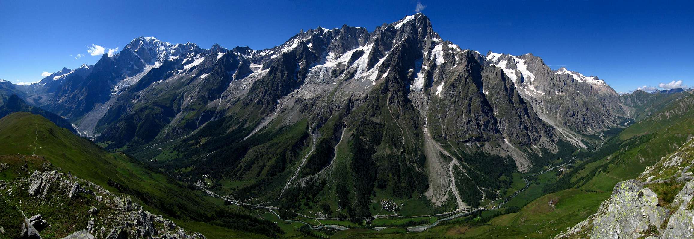
Testa Bernarda towards complete Mont Blanc Chain with Vény & Ferret Valleys, by as
Approach from Courmayeur:
La Valle di Aosta é una piccola Regione nella grandezza dell'intero arco alpino, però possiede una infinità di posti dove si posson effettuare belle e facili escursioni. Tra queste la Val Sapin, proprio alle porte di Courmayeur, località che con le sue due Valli laterali di Veny a Sudovest e Ferret a Nordest conclude il dispiegamento delle vallate, prima che il Monte Bianco separi l'Italia dalla Savoia in territorio francese. Dall'alto essa ostenta le sue tredici Valli ed i molteplici Valloni, che offrono variegate opportunità di frequentarla e conoscerla. In questo piccolo lavoro, invece, si ha la pretesa di farvele conoscere se non completamente, almeno in modo parziale con vista da lontano verso tutte le sue principali Vallate, proponendo una serie di vedute con l'obiettivo primario di farvi spaziare quasi a 360° su tutta la Valle di Aosta. Su quasi tutta ma, soprattutto, in tutta perché le medesime comportano la presa in visione diretta dell'intero territorio guardando da Occidente verso Oriente, ovvero dall'"Alta Valle" in direzione della "Medio-Bassa Valle". Ma, qui, l'obiettivo principale é quello di dar una occhiata da vicino alla imponente Catena del Monte Bianco che, dallo spartiacque tra la Val Sapin e la Val Ferret italiana, si distende in tutta la sua grandezza dal Col de la Seigne, prima dell'Aiguille des Glaciers, a quello di Ferret, dopo il Mont Dolent ed il Mont Grapillon. Un grande balcone, sopra al quale sembrano precipitare Les Grandes Jorasses, mentre sul lato opposto la Grande Rochère, da qui veramente bella ed ardita, deve ridimensionare alquanto le sue pretese adattandosi al ruolo di comparsa. Ciononostante noi un'occhiata ammirata la rivolgiamo pur a lei, prima d'iniziare la traversata completa sullo spartiacque che, scavalcando la Tête de la Tronche, la Testa Bernarda ed il lungo crinale del Mont de la Saxe, ci fà raggiungere il Rifugio Giorgio Bertone, sopra quello splendido promontorio erboso-roccioso dominante completamente la Valle, costituendo il perno divisorio tra le Valli di Veny e di Ferret e sopra l'abitato di Courmayeur. Qui gli occhi sono esclusivamente per l'intera Catena del Monte Bianco passando dalle mastodontiche Jorasses, al minuscolo Dente del Gigante ed all'Aiguille Noire de Péuterey, che, civettuola e superbamente slanciata al cielo, sfida anche Sua Maestà.
Getting There
BY CAR:- From TORINO, MILANO, etc: Motorway A5. Exit at IVREA or Quincinetto (PIEDMONT).
- From IVREA Town: in West (Southern side) to Pont Saint Martin, Donnas, Bard, Champdepraz, Pontey, Fénis, Saint Marcel, Grand Brissogne, Pollein, Charvensod, Gressan, Jovençan, Aymavilles, to Villeneuve, Arvier, Avise, Morgex (Internal side) and to Pré Saint Didier, Courmayeur Municipalities (Western side). From Courmayeur Resort: in East towards Pré Saint Didier and Morgex Municipalities.
- From Courmayeur-la Palud (1.370m), towards Montitaz, Planpincieux (1.593m) Villages, Tronchey (1.620m), Praz Sec du Milieu, Lavachey (1.640m), Arnouva Dèsot (1.769m) Villages, through Municipal Road, to Malatrà Vallon and Walter Bonatti Refuge. Also from Arp Nouva to Elena Refuge, through dirt road on valley floor; or from the fork after Planpincieux, small bridge, towards Leuchey Dèsott, Damon Pastures to Mont de la Saxe Hump/Giorgio Bertone Refuge.
Specific Road
- From Courmayeur-Villair Dessus (1.282m), reachable with Municipal Road by Courmayeur Center neighbor "Museo Alpino", continue North in Val Sapin, through dirt road to fork 1.470 meters with the trail n° 42/TMB to Refuge Bertone. Also by the path n° 38, concomitant with the private dirt road, continue more in Northeast towards La Trappa little Hamlet (1.505m) and from this, exclusively through the same path, to small Tsapy Village (1.635m), nearby the "Trou des Romains", ancient goldmine.
- From FRANCE: through the Mont Blanc Tunnel to Entrèves-crossroads to Vény/Ferret Valleys - Mountain Guides of Courmayeur - La Saxe Rock Gym - Courmayeur. By Little Saint Bernard Pass, closed since November until half May to La Thuile Valley - Pré Saint Didier - Courmayeur. It is not necessary to take Motorway A5: you can drive on SS.26, in the direction of AOSTA - IVREA - TURIN.
BY PLANE:
- Aeroporto "Corrado Gex" Saint Christophe (Aosta).
Approaches & Route Description
Approach from Courmayeur:
by Courmayeur Center neighbor the "Museo Alpino" (1.220m about), take the Municipal Road to the North in Val Sapin, in parallel towards East with this more important and wide of the Val Ferret, that reaches the eponymous hill where the end Graians and begin the Pennine Alps to which belong the Summits addressed in this Route (Tête de la Tronche, Testa Bernarda, Mont de la Saxe). Reached Villair-dessus where this ends for the use without its permission (1.382m; cartel ban immediately after the village); from this point start to climb towards the Northeast, through the same one that coincides with the path n° 38 until you reach the junction 1.470 meters which, through the n° 42/TMB to the West-northwest, reaches the Refuge Giorgio Bertone at the beginning along the watershed of the Mont de la Saxe. Abandoned this on the left, proceed on the valley floor always with the Northeast direction until you come to the next little Village of La Trappa(e) (1.505m) and from this, exclusively through the same path to the equally tiny Village Tsapy (1.635m), very close the famous "Trou des Romains", where there is an ancient Roman Goldmine, now long abandoned and closed (E/F; 1h'00/1h'15).
![]()
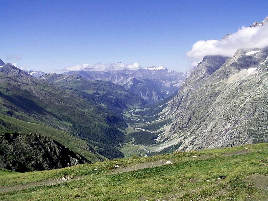
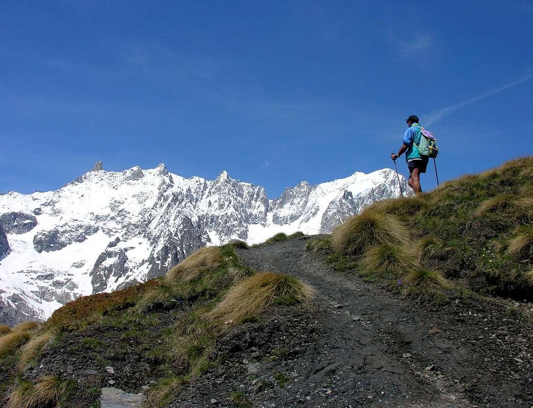
Val Ferret Mountains from Testa Bernarda (2.534m) with Eastern view, by andrea.it
Avvicinamento da Courmayeur:
![]()
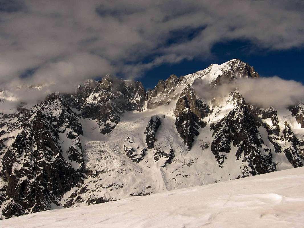
Middle Mont de la Saxe (2.348m) to Grandes Jorasses (4.208m), by m g schiapparelli
Route from Tsapy or Chapy Hamlet (1.635m) towards Sapin Hill 2.435m:
Avvicinamento da Courmayeur:
dal Centro di Courmayeur, nei pressi del "Museo Alpino" (circa 1.220 m), prendere la Strada Municipale che s'indirizza a Nord verso la Val Sapin, parallela ad Oriente della più importante ed estesa Val Ferret, che raggiunge l'omonimo colle dove terminano le Alpi Graie ed iniziano quelle Pennine alle quali appartengono le Sommità trattate in questa Route. Raggiunto il Villair-dessus ove questa termina per l'uilizzo dei mezzi privi di relativo permesso (1.382 m; cartello di divieto subito dopo il villaggio); da questo punto iniziare a salire verso Nordest, tramite la stessa che coincide con il sentiero n° 38 fino a raggiungere il bivio 1.470 metri che, tramite il sentiero n° 42/TMB verso Ovest-nordovest, perviene al Rifugio Giorgio Bertone all'inizio del lungo spartiacque del Mont de la Saxe. Abbandonato questo sulla sinistra, procedere invece sul fondovalle sempre con direzione Nordest sino a pervenire al successivo Villaggetto di La Trappa(e) (1.505 m) e da questo, esclusivamente tramite lo stesso sentiero all'altrettanto minuscolo Villaggio di Tsapy (1.635 m), nelle strette vicinanze del famoso "Trou des Romains", ove esiste una antica Miniera d'oro dei Romani, ormai da tempo abbandonata e chiusa (E/F; 1h'00/1h'15).
Route from Tsapy or Chapy Hamlet (1.635m) towards Sapin Hill 2.435m:
from the Village Tsapy, collocated at the center of the valley and at the end of the private dirt road, leaving to the North the old route that runs along the bottom of the valley along the Torrent de Tsapy then navigate to the Northeast to the hill, climb decidedly to the East via the trail n° 43/44, which quickly reaches the Pasture of Freydevaz (1.739m). From here with sharp bends and semi circular path towards the Northeast to the alternative 2.962 meters, just before the Torrent de Currù in the adjacent vallon. Discarded in South deviation, that by the trail n° 43A leads to Alpages La Suche (1.810m), just after you reach the torrent. From this you leave on the right (East) the deviation with the trail n° 44 that leads to Liconi Hill and namesake Lake (2.674m, 2.555m), continuing, by means of a short descent, the path followed up to here which comes in a short time the Alp of Currù (1.964m); from here a long diagonal to the North, dominating from the high the walloon, easily leads to the hill by a long series of hairpin bends (E/F; 2h'15/2h'30).
Variant with ancient route on valley floor: from Tsapy, where both the private dirt road that the concomitant trail n° 38, ends, continue in the same direction, but with a smaller path and not numbered, going for a short time along the shore hydrographic right of the Torrent de Sapin for then wade the same and continue on the other side until the altitude 1.732 meters, where you will return with a new ford to the West. From this point the trail, always going up next to the same torrent, bends most at Northwest reaching the altitude of 2.164 meters, where it ends; reach through grassy slopes-detrital subsequent to altitude 2.223 meters at two branches that give rise to the creek and, after crossing a small secondary walloon toward the Northeast, always using the same type of ground in a short time to reach the Sapin Hill (2.435m; EE/F; 1h'45/2h'15).
![]()
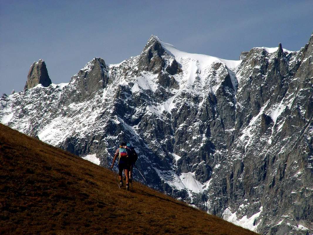
At beginning of Mont de la Saxe towards Southeastern Mont Blanc (4.811m), by livioz
Via dal Villaggio di Tsapy o Chapy verso il Col Sapin:
![]()
Southern Mont de la Saxe (2.251m) towards Grandes Jorasses (4.208m), by Antonio
Variant with ancient route on valley floor: from Tsapy, where both the private dirt road that the concomitant trail n° 38, ends, continue in the same direction, but with a smaller path and not numbered, going for a short time along the shore hydrographic right of the Torrent de Sapin for then wade the same and continue on the other side until the altitude 1.732 meters, where you will return with a new ford to the West. From this point the trail, always going up next to the same torrent, bends most at Northwest reaching the altitude of 2.164 meters, where it ends; reach through grassy slopes-detrital subsequent to altitude 2.223 meters at two branches that give rise to the creek and, after crossing a small secondary walloon toward the Northeast, always using the same type of ground in a short time to reach the Sapin Hill (2.435m; EE/F; 1h'45/2h'15).
Via dal Villaggio di Tsapy o Chapy verso il Col Sapin:
da Tsapy (1.635 m) al termine della poderale, lasciata sulla sinistra la vecchia via percorrente il fondo del vallone lungo il Torrent de Tsapy per poi traversare verso Nordest al colle, salire invece decisamente ad Oriente tramite il sentiero n° 43/44, che in breve tempo raggiunge l'Alpeggio di Freydevaz (1.739 m). Da qui con stretti tornanti e percorso semicircolare verso Nordest si raggiunge il bivio 2.962 metri, poco prima del Torrent de Currù nell'adiacente vallone. Scartata a Sud la deviazione, che tramite il sentiero n° 43A conduce all'Alpe La Suche (1.810 m), subito dopo si raggiunge il torrente. Da questo si abbandona sulla destra (Est) la deviazione che con il sentiero n° 44 porta al Colle di Liconi ed omonimo Lago (2.674 m, 2.555 m), proseguendo, per mezzo d'una corta discesa, col sentiero sin qui seguito, che arriva in breve tempo all'Alpe del Currù (1.964 m); da qui un lungo diagonale a Settentrione, dominando dall'alto il vallone, conduce facilmente al colle per mezzo di una numerosa serie di stretti tornantini (2.435 m; E/F; 2h'15/2h'30).
Variante sul fondovalle: da Tsapy, al termine della poderale e del concomitante sentiero n° 38, si prosegue sempre nella stessa direzione, ma con un sentiero più piccolo e non numerato, salendo per breve tempo lungo la sponda idrografica destra del Torrent de Sapin per poi guadare lo stesso e proseguire sulla sponda opposta fino all'altitudine 1.732 metri, dove si ritorna con un nuovo guado ad Occidente. Da questo punto il sentiero, salendo sempre affianco al torrente medesimo, flette maggiormente a Nordovest raggiungendo l'altitudine di 2.164 metri, dove termina; pervenire per mezzo di pendii erboso-detritici alla successiva di 2.223 metri presso due rami originanti il torrente e, dopo aver attraversato verso Nordest un valloncello secondario, sempre tramite stessa tipologia di terreno, in breve tempo raggiungere il Col Sapin (2.435 m; EE/F; 1h'45/2h'15).
Variante sul fondovalle: da Tsapy, al termine della poderale e del concomitante sentiero n° 38, si prosegue sempre nella stessa direzione, ma con un sentiero più piccolo e non numerato, salendo per breve tempo lungo la sponda idrografica destra del Torrent de Sapin per poi guadare lo stesso e proseguire sulla sponda opposta fino all'altitudine 1.732 metri, dove si ritorna con un nuovo guado ad Occidente. Da questo punto il sentiero, salendo sempre affianco al torrente medesimo, flette maggiormente a Nordovest raggiungendo l'altitudine di 2.164 metri, dove termina; pervenire per mezzo di pendii erboso-detritici alla successiva di 2.223 metri presso due rami originanti il torrente e, dopo aver attraversato verso Nordest un valloncello secondario, sempre tramite stessa tipologia di terreno, in breve tempo raggiungere il Col Sapin (2.435 m; EE/F; 1h'45/2h'15).
From Col Sapin by traverse up to the Refuge Giorgio Bertone:
Col Sapin (2.435m), left to right branch that goes down to the Tsa (more high Alp) de Sécheron (2.260m) into the adjacent Armina(z) Walloon, continue with the trail n° 42 in the Southeast Ridge of the Tête of Tronche (2.584m) to reach the same easily and quickly; from here the same, dropping more westward, reaches a wide saddle (2.495m), after which you reach the Testa Bernarda (2.534m). From this point the trail is addressed decisively in the Southwest, reaching the Mont de la Saxe Northern (2.403m), at the apex of the long watershed between Val Sapin and Val Ferret in opposite. A "walk" on the top in the middle of grassy slopes and some ponds leads to Quota (2.333m), where it comes from a path below Lechère Pasture (2.115m), and the subsequent Mont de la Saxe of Middle (2.348m); off to another Quota (2.311m), which, again from Val Ferret, there's other two paths: one from Lechère and the other from the two Alpags of Lèche and Leuchey-Damon. Two other altitudes (2.251m, 2.227m) form the Southern Mont de la Saxe, just above the Alp Praz de la Saxe (1.991m), immediately below which is situated in a pleasant promontory the Refuge Giorgio Bertone (1.946m; E/F; 1h'30/2h'00 by Col Sapin).
![]()
Mont de la Saxe towards Mont Chétif (2.343m), by Maria Grazia Schiapparelli
Dal Col Sapin in traversata fino al Rifugio Giorgio Bertone:
![]()
Dent du Géant & Rochefort Ridge crossing on Mont de la Saxe, by emilius
From Val Ferret to Rifugio Giorgio Bertone and crossing towards the Col Sapin and Alp:
from the Regional Road of Val Ferret at the nearby crossroads between the two small Hamlets of Mayen (1.503m) and Montitaz (1.550m), which leads to the Village of Pont Pailler (1.487m) after having crossed the Dora Ferret on a small bridge; just before the village begin to rise to the East via the path n° 32, which progressively reaches the Pastures of Leuchey Dèsott and Damon (1.929m; * Note: Leuchey Dèsott you can get even with a private farm dirt road concomitant with route n° 31 that starts later at the Camping "Grandes Jorasses" to Planpincieux 1.593 meters). From what Damon (Upper) continue to Southeast under Western slopes of Mont de la Saxe and through the trail n° 31/TMB/Alta Via n° 1 with a long diagonal reach Bertone Shelter (E/F; 1h'20/1h'40). From the hut take in reverse the previous route, climbed Mont de la Saxe, Testa Bernarda, Tête de la Tronche come to Col Sapin and its relative descent (E/F; 2h'00/2h'30 for complete crossing towards Col Tsapy; 4h'30/5h'00 to the Village of Tsapy).
![]()
Dente del Gigante, Rochefort Ridge & Gr. Jorasses from Mont de la Saxe, by dante
Col Sapin (2.435m), left to right branch that goes down to the Tsa (more high Alp) de Sécheron (2.260m) into the adjacent Armina(z) Walloon, continue with the trail n° 42 in the Southeast Ridge of the Tête of Tronche (2.584m) to reach the same easily and quickly; from here the same, dropping more westward, reaches a wide saddle (2.495m), after which you reach the Testa Bernarda (2.534m). From this point the trail is addressed decisively in the Southwest, reaching the Mont de la Saxe Northern (2.403m), at the apex of the long watershed between Val Sapin and Val Ferret in opposite. A "walk" on the top in the middle of grassy slopes and some ponds leads to Quota (2.333m), where it comes from a path below Lechère Pasture (2.115m), and the subsequent Mont de la Saxe of Middle (2.348m); off to another Quota (2.311m), which, again from Val Ferret, there's other two paths: one from Lechère and the other from the two Alpags of Lèche and Leuchey-Damon. Two other altitudes (2.251m, 2.227m) form the Southern Mont de la Saxe, just above the Alp Praz de la Saxe (1.991m), immediately below which is situated in a pleasant promontory the Refuge Giorgio Bertone (1.946m; E/F; 1h'30/2h'00 by Col Sapin).
Dal Col Sapin in traversata fino al Rifugio Giorgio Bertone:
dal Col Sapin (2.435 m), lasciata a destra la diramazione che scende alla Alpe di Sécheron, continuare con il sentiero n° 42 sotto la Cresta Sudest della Tête de la Tronche (2.584 m) raggiungendo la medesima facilmente ed in breve tempo; da qui lo stesso, scendendo più verso Ovest, raggiunge una larga sella (2.495 m), dopo la quale si raggiunge la Testa Bernarda (2.534 m). Da questo punto il sentiero si indirizza decisamente a Sudovest raggiungendo il Mont de la Saxe Settentrionale (2.403 m), allo apice del lungo spartiacque tra la Val Sapin e la Val Ferret. Una "passeggiata" sul culmine in mezzo a pendii prativi e qualche laghetto conduce alla Quota (2.333 m), dove arriva un sentierino dalla sottostante Alpe di Lechére, ed alla successiva (2.348 m) o Mont de la Saxe di Mezzo; scendere ad un'altra Quota (2.311 m), alla quale, sempre dalla val Ferret, arrivano altri due sentieri: uno da Lechère e l'altro dalle Alpi di Lèche e di Leuchey-Damon. Altre due Quote (2.251 m, 2.227 m) costituiscono il Mont de la Saxe Meridionale, appena al di sopra dell'Alpe Praz de la Saxe (1.991 m), appena al di sotto della quale é situato in un ameno promontorio il Rifugio Giorgio Bertone (1.946 m; E/F; 1h'30/2h'00 dal Col Sapin).
From Val Ferret to Rifugio Giorgio Bertone and crossing towards the Col Sapin and Alp:
from the Regional Road of Val Ferret at the nearby crossroads between the two small Hamlets of Mayen (1.503m) and Montitaz (1.550m), which leads to the Village of Pont Pailler (1.487m) after having crossed the Dora Ferret on a small bridge; just before the village begin to rise to the East via the path n° 32, which progressively reaches the Pastures of Leuchey Dèsott and Damon (1.929m; * Note: Leuchey Dèsott you can get even with a private farm dirt road concomitant with route n° 31 that starts later at the Camping "Grandes Jorasses" to Planpincieux 1.593 meters). From what Damon (Upper) continue to Southeast under Western slopes of Mont de la Saxe and through the trail n° 31/TMB/Alta Via n° 1 with a long diagonal reach Bertone Shelter (E/F; 1h'20/1h'40). From the hut take in reverse the previous route, climbed Mont de la Saxe, Testa Bernarda, Tête de la Tronche come to Col Sapin and its relative descent (E/F; 2h'00/2h'30 for complete crossing towards Col Tsapy; 4h'30/5h'00 to the Village of Tsapy).
Dalla Val Ferret al Rifugio Giorgio Bertone e traversata al Col Sapin ed Alpe:
dalla Regionale della Val Ferret raggiungere il vicino bivio tra i Villaggetti di Mayen (1.503 m) e Montitaz (1.550 m), che porta a quello di Pont Pailler (1.487 m) dopo aver attraversata la Dora di Ferret su d'un ponticello; appena prima dello stesso iniziare a salire verso Oriente tramite il sentiero n° 32, che in progressione raggiunge le Alpi di Leuchey Dèsott e Damon (1.929 m; * Nota: a Dèsott si può arrivare anche con strada poderale concomitante con il sentiero n° 31 che parte più avanti presso il Camping "Grandes Jorasses" a Planpincieux). Da Damon (di Sopra) continuare verso Sudest alle pendici Occidentali del Mont de la Saxe e per mezzo del sentiero n° 31TMB/Alta Via n° 1 raggiungere con lungo diagonale il Rifugio Giorgio Bertone (E/F; 1h'20/1h'40). Dal rifugio percorrere in senso inverso il precedente itinerario che, scavalcato Mont de la Saxe, Testa Bernarda e Tête de la Tronche perviene al Col Sapin e relativa discesa (E/F; 2h'00/2h'30 per la traversata al Col Tsapy; 4h'30/5h'00 fino al Villaggio di Tsapy).
![]()
Winter Dôme & Grandes Jorasses from Mont de la Saxe or Southeast, by andrea.it
dalla Regionale della Val Ferret raggiungere il vicino bivio tra i Villaggetti di Mayen (1.503 m) e Montitaz (1.550 m), che porta a quello di Pont Pailler (1.487 m) dopo aver attraversata la Dora di Ferret su d'un ponticello; appena prima dello stesso iniziare a salire verso Oriente tramite il sentiero n° 32, che in progressione raggiunge le Alpi di Leuchey Dèsott e Damon (1.929 m; * Nota: a Dèsott si può arrivare anche con strada poderale concomitante con il sentiero n° 31 che parte più avanti presso il Camping "Grandes Jorasses" a Planpincieux). Da Damon (di Sopra) continuare verso Sudest alle pendici Occidentali del Mont de la Saxe e per mezzo del sentiero n° 31TMB/Alta Via n° 1 raggiungere con lungo diagonale il Rifugio Giorgio Bertone (E/F; 1h'20/1h'40). Dal rifugio percorrere in senso inverso il precedente itinerario che, scavalcato Mont de la Saxe, Testa Bernarda e Tête de la Tronche perviene al Col Sapin e relativa discesa (E/F; 2h'00/2h'30 per la traversata al Col Tsapy; 4h'30/5h'00 fino al Villaggio di Tsapy).
Val Sapin towards Bertone Shelter and crossing to Sapin Hill with return to the Alp:
from the junction 1.470 meters before lthe small Village of la Trappe with the path-mule track n° 42/TMB to the West or from the next village (1.505m; beautiful fountain on the dirt road) through a path in the Southwest diagonally unnumbered, which is linked to the previous one at the junction 1.547 meters, continue the trail through numerous and steep hairpin bends on the muletrack that crosses the beautiful forest of larch and fir trees reaching altidudine of 1.711 meters, at some rocky bands. Coming out of the forest in the area more open and leaving on the left a viewpoint, from this point the trail, through path at first more in the Southwest then to the Northwest, reaches a broad and grassy hump where the shelter is located, whence the previous itinerary will continue on the watershed crossing all the Summits to the Col Sapin and then the descent to the Village Tsapy with one of the two options described above (E/F; 1h'15/1h'30; 2h'15/2h'30 for complete crossing towards Col Tsapy; 5h'15/5h'30 to the Tsapy Village).
![]()
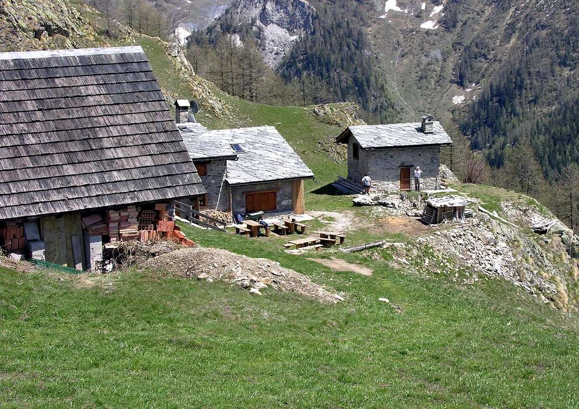
Giorgio Bertone Refuge (1.946m)) near Praz Alp at Mont de la Saxe, by Antonio
from the junction 1.470 meters before lthe small Village of la Trappe with the path-mule track n° 42/TMB to the West or from the next village (1.505m; beautiful fountain on the dirt road) through a path in the Southwest diagonally unnumbered, which is linked to the previous one at the junction 1.547 meters, continue the trail through numerous and steep hairpin bends on the muletrack that crosses the beautiful forest of larch and fir trees reaching altidudine of 1.711 meters, at some rocky bands. Coming out of the forest in the area more open and leaving on the left a viewpoint, from this point the trail, through path at first more in the Southwest then to the Northwest, reaches a broad and grassy hump where the shelter is located, whence the previous itinerary will continue on the watershed crossing all the Summits to the Col Sapin and then the descent to the Village Tsapy with one of the two options described above (E/F; 1h'15/1h'30; 2h'15/2h'30 for complete crossing towards Col Tsapy; 5h'15/5h'30 to the Tsapy Village).
Dalla Val Sapin al Rifugio Bertone e traversata al Col Sapin con rientro all'Alpe:
dal bivio 1.470 metri prima di la Trappe con il sentiero-mulattiera n° 42/TMB verso Occidente o dal successivo villaggio (1.505 m; bella fontana sulla strada) tramite un sentierino a Sudovest in diagonale non numerato, che si ricollega al precedente al bivio 1.547 metri, proseguire con percorso tramite numerosi ripidi tornanti sulla mulattiera che attraversa la splendida foresta di larici ed abeti raggiungendo l'altidudine di 1.711 metri, presso alcune fasce rocciose. Procedendo su terreno gradualmente sempre più aperto e lasciando sulla sinistra un punto panoramico, da questo punto la mulattiera, tramite percorso dapprima maggiormente a Sudovest poi a Nordovest, raggiunge un dosso ampio ed erboso ove é collocato il Rifugio Giorgio Bertone, donde con il precedente itinerario si continua la traversata di tutte le Sommità sino al Col Sapin per poi effettuare la discesa al Villaggio di Tsapy con una delle due possibilità di cui sopra (E/F; 1h'15/1h'30; 2h'15/2h'30 per la completa traversata al Col Tsapy; 5h'15/5h'30 sino al Villaggio di Tsapy).
This route can be considered E/F or EE/F+ (Experts Hikers) in winter (even by snowshoes or Ski).
L'itinerario è da classificare in E/F oppure EE/F+ (Escursionisti Esperti) in inverno (anche tramite Racchette da neve od in Scialpinismo).
![]()
Col de Grandes Jorasses & Jorasses from Mont de la Saxe or Southeast, by emilius
EQUIPMENT
Hiking gear, in winter as for Ski-Mountaineering or with Snowshoes.
Da Escursionismo, in inverno da Scialpinismo o con Racchette da neve.
dal bivio 1.470 metri prima di la Trappe con il sentiero-mulattiera n° 42/TMB verso Occidente o dal successivo villaggio (1.505 m; bella fontana sulla strada) tramite un sentierino a Sudovest in diagonale non numerato, che si ricollega al precedente al bivio 1.547 metri, proseguire con percorso tramite numerosi ripidi tornanti sulla mulattiera che attraversa la splendida foresta di larici ed abeti raggiungendo l'altidudine di 1.711 metri, presso alcune fasce rocciose. Procedendo su terreno gradualmente sempre più aperto e lasciando sulla sinistra un punto panoramico, da questo punto la mulattiera, tramite percorso dapprima maggiormente a Sudovest poi a Nordovest, raggiunge un dosso ampio ed erboso ove é collocato il Rifugio Giorgio Bertone, donde con il precedente itinerario si continua la traversata di tutte le Sommità sino al Col Sapin per poi effettuare la discesa al Villaggio di Tsapy con una delle due possibilità di cui sopra (E/F; 1h'15/1h'30; 2h'15/2h'30 per la completa traversata al Col Tsapy; 5h'15/5h'30 sino al Villaggio di Tsapy).
Difficulty & Equipment
DIFFICULTIESThis route can be considered E/F or EE/F+ (Experts Hikers) in winter (even by snowshoes or Ski).
L'itinerario è da classificare in E/F oppure EE/F+ (Escursionisti Esperti) in inverno (anche tramite Racchette da neve od in Scialpinismo).
EQUIPMENT
Hiking gear, in winter as for Ski-Mountaineering or with Snowshoes.
Da Escursionismo, in inverno da Scialpinismo o con Racchette da neve.
Campings
Remember that free camping is forbidden (except for emergency reasons, over 2.500m, from darkness until dawn).Mountain Condition
- Meteo: you can find all the needed informations at the official site of the Valle d'Aosta Region:
- Valle d'Aosta Meteo
Important Information
- REGIONE AUTONOMA VALLE D'AOSTA the official site.
- FONDAZIONE MONTAGNA SICURA Villa Cameron, località Villard de la Palud n° 1 Courmayeur (AO) Tel: 39 0165 897602 - Fax: 39 0165 897647.
- A.I.NE.VA. (Associazione Interregionale Neve e Valanghe).
Useful numbers
- Protezione Civile Valdostana località Aeroporto n° 7/A Saint Christophe (Ao) Tel. 0165-238222.
- Bollettino Meteo (weather info) Tel. 0165-44113.
- Unità Operativa di Soccorso Sanitario Tel. 118.