
-
 9236 Hits
-
 89.39% Score
-
 29 Votes
|
|
Mountain/Rock |
|---|---|
|
|
46.85550°N / 11.21378°E |
|
|
Hiking, Scrambling |
|
|
Spring, Summer, Fall |
|
|
8999 ft / 2743 m |
|
|
Overview
 Weiße Wand and Hohe Kreuzspitze Weiße Wand and Hohe Kreuzspitze |
The southern Stubai Alps are a geologically complex mountain range. While most of the mountains consist of micaceous schist, either reddish one near the main ridge or dark green one in the south, in several places different kind of rocks come to the surface. Indeed the area has been intensive mining operations going on over the last centuries, up to heights of more than 2600m. As part of this complex structure, in several places single mountains differ completely from their neighborhood and nowhere is this more apparent as with the limestone and marble summits of the area.
One large - in fact the largest - "aberration" can be found in the very south-west of the Stubai Alps, where the Jaufenkamm Ridge towers above the Passeier Valley / Val Passira and bends northward to join the main ridge. Here, between Zermaidspitze / Cima Zermedo in the north and Kleine Kreuzspitze / Piccola Punta di Monte Croce, you find a whole ridge, made up from limestone and consisting of three major mountains, Hochwart / Guardia Alta, Weiße Wand / Croda Bianca and the highest one, Hohe Kreuzspitze / Monte Altacroce.
While not really among the highest mountains of the Stubai Alps these three summits and mainly Hohe Kreuzspitze stand out from all sides, not only because of their white limestone but also because of their form and location. They tower about 1500m above the Passeiertal Valley / Val Passira to the west and Ratschingstal / Val Racines to the north-east. Reaching the summit of Hohe Kreuzspitze therefore means climbing all this elevation difference or as an alternative hike all the way from Jaufenpass along the Jaufenkamm Ridge. Since between Jaufenpass and Hohe Kreuzspitze the trail ascends four summits the overall gain in elevation is almost the same as the one from the valley floors.
Of the three ridges which lead to the summit of Hohe Kreuzspitze, the north-western one is used as the normal ascent, starting from Ratschingstal / Val Racines. Only the last few steps run along that ridge which is moderately exposed. The east ridge, which heads up from Kleine Kreuzspitze is also not overly difficult though it definitely is long and exposed. In some sections you have to climb along narrow and exposed ledges to pass obstacles on the ridge. The most difficult route is the south route, which starts deep in Passeiertal / Val Passira and which heads into a cirque underneath the summit. From there it is a hike on limestone scree which joins the south ridge about 200m beneath the summit. Like the east ridge route it is very exposed in places.
|


Getting There
MatatzspitzeMuthspitzeHochwartSpitzhornKolbenspitzeSchwarzkopfTschigat/RötelspitzeLodnerHohe WeißeHohe WildeSeelenkögelLiebener SpitzeHochfirstEssener SpitzeGranatenkogelWurmkogelWildspitzeHohe Kreuzspitze 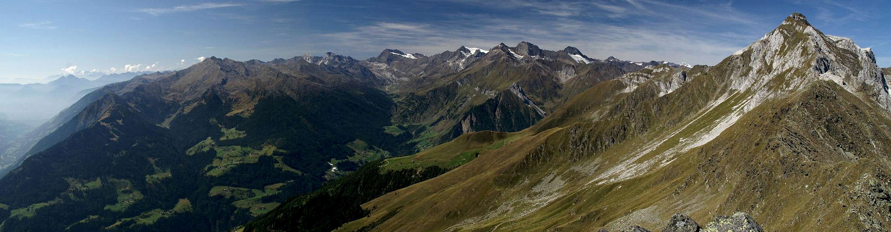  |
- Jaufenpass trailhead
The mountain can be easily reached from the Brenner Motorway A22. Take the exit Sterzing / Vipiteno and follow the signs for SS44 in direction Jaufenpass / Passo Giovo. Drive accross the pass and start at the first switchback curve (Römerkehre), where you can find a small parking lot a fem meters beside the road.
From Meran / Merano take Passeier Staatsstraße (also SS44) in direction Timmelsjoch / Passo del Rombo and Jaufenpass / Passo Giovo. At St Leonhard / San Leonardo turn east (staying on SS44) until you reach the curve "Römerkehre".
- Ratschingstal / Val Racines trailhead
Take the Brenner Motorway A22 and leave it at Sterzing / Vipiteno. Follow the signs to Jaufenpass but at the roundabout head for Ratschingstal / Val Racines. At Stange / Stanga Ratschingstal leaves the main valley to the left. Follow the road to its end in Flading.
- Passeiertal / Val Passira trailhead
From Meran / Merano take SS44 in direction Timmelsjoch / Passo del Rombo and Jaufenpass / Passo Giovo. At St Leonhard / San Leonardo turn west (switching to on SS44b) until you reach Moos / Moso.
|


Red Tape
 Haflinger Horses in front of Hohe Kreuzspitze
There is no red tape except for camping regulations. You are not allowed to freely camp anywhere except at the campgrounds which you find in the valleys.
Accommodation
Rooms and Apartments
Eisacktal / Valle Isarco
Passeiertal / Val Passiria
Burggrafenamt
Camping
- The closest campgrounds are at Gasteig / Casateia in Ratschingstal / Valle di Racines and at St. Leonard / San Leonardo in Passeiertal / Val Passira. Both are located on SS44 to Jaufenpass / Passo del Giovo.
Huts
- There is one hut, Flecknerhütte close by but rather close to the trailhead near the Jaufenpass road. You can also use the hotels/restaurants at Jaufenpass / Passo Giovo, Jaufenhaus and Enzianhütte.
Weather Conditions
 Hohe Kreuzspitze shrouded by clouds
Maps & Books
Maps
- Digital Maps
- Regular Maps
- Sarntal/Val Sarentino
Kompass Map WK 056
1:35.000
ISBN: 3-85491-340-0
- Sterzing / Vipiteno
Kompass Map WK 44
1:50.000
ISBN: 3-85491-050-9
- VAL PASSIRIA / PASSEIERTAL
Tabacco Map 039
1:25000
Books
- Meran-Burggrafenamt
Franziska Baumann
Kompass Guidebook WF951
Kompass Verlag
ISBN: 3-85491-386-9
- Rund um Sterzing
Henriette Klier / Walter Klier
Rother Verlag
ISBN: 3-7633-4167-6
- Rund um Meran
Henriette Klier
Rother Verlag
ISBN: 3-7633-4290-7
- Sarntal/Val Sarentino