
|
|
Mountain/Rock |
|---|---|
|
|
41.91140°N / 111.6747°W |
|
|
9979 ft / 3042 m |
|
|
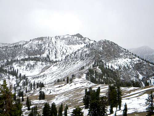
Naomi Peak from the north.
Overview
Naomi Peak is the highest summit in the Bear River Range of extreme northeast Utah into southeast Idaho, west of Bear Lake. According to Mountaingazelle’s Bear River Range page, the name originates from the Bible. Naomi was mother-in-law of Ruth in the Old Testament. In addition to being the highest summit of the range, it is probably the most accessible and climbed due to the proximity to the main trailhead at Tony Grove Lake at the end of a well maintained paved road. The 9,828 foot summit has an impressive prominence of 3,159 ft.
Naomi Peak is situated on the main crest of the Bear River Range, about one mile east of Mount Magog and just under two miles northwest of Tony Grove Lake. To the north and east, the terrain drips into a series of cirques and gentle basins that hold three lakes; Tony Grove Lake, White Pine Lake and High Creek Lake and one seasonal pond. To the west the steep slopes are carved and dissected into a series of need ravines and draws that empty into Smithfield Canyon. The relief is generally 1-2,000 feet to the eastern basins, but the drop to the west off the summit block is approximately 3,000 feet.
The mountain is composed of dolomite over quartzite formed from ancient tidal mud and coastal beaches. There are a handful of small caves in the area and occasional fossils can be found. The upper subalpine slopes are near the climatic timberline for the area and support open forests of limber pine, whitebark pine, subalpine fir and spruce, with occasional Douglas fir. The area is included in the Naomi Peak Wilderness, which unfortunately can be overrun with cows parts of the year. In the fall, the trailhead areas are heavily hunted so wear orange.
 |  |  |  |  |
Getting There
The easiest routes to this summit start at Tony Grove Lake. To reach the trailhead at Tony Grove from Logan, Utah, head east up Logan Canyon. The directions start on main street in Logan, then turn east on 400 North. Follow the signs for Logan Canyon, Bear Lake and Highway 89. 400 North becomes Highway 89 and gives a beautiful drive up the twisting, narrow Logan Canyon. After driving for about 19 miles look for the turn off to Tony Grove, which is well signed. Take the turn and proceed seven miles to the end of the road and trailhead at Tony Grove Lake. The route to the summit is very straightforward. Just follow the trail to the divide just north of the summit and then turn south and follow the ridgeline a short distance to the summit.Routes from the west involve longer extended hikes from the Smithfield, Creek, Cherry Creek or High Creek basins. Follow these to the High Lake vicinity and ascend the ridge to the divide. The west slope is rugged here so plan carefully. If desired, the trail can be taken from High Lake to the ridgeline north of Naomi Peak.
 |  |  |  |
Red Tape
No special permits are required. However, there is now a $6 concessionaire permit to maintain services at the trailhead.When To Climb
The summer is the best time to climb this mountain. Winter access is possible, but would require a long approach on snowshoes. Snowmobiles can actually enter the Tony Grove area and one can do this, and then have a more limited hike in the adjacent peaks. Getting to Naomi and the other summits adjacent the trailhead wouldn’t be very difficult. Standard hiking is possible late in the fall until the first heavy snows, generally in late October or early November. If hiking this time of year pay attention to the weather forecasts and remember that the days are short.Camping
There are several excellent camping opportunities in the vicinity of this mountain. For those wishing to camp out of a car, there is Tony Grove Campground at Tony Grove Lake near the trailhead. This is a large campground easily reached from Logan on a paved road. Thus it can fill up frequently in the summer so reservations may be advisable. There is no drinking water, but toilets are available. Tony Grove offers a nice lake with a nature trail, fishing and several opportunities for day hikes of any length or difficulty.Backpackers can find good camping at White Pine Lake or High Creek Lake. White Pine Lake can get crowded and this is being managed by signs indicating designated camping and non-camping areas near the lake. This lake is about a four mile hike from Tony Grove. High Creek Lake is close to all the peaks, but rugged terrain on the west side of the divide makes it less accessible to them. The basin above White Pine Lake or the basins north or west of Mount Gog offer more remote and isolated camping opportunities. There are several streams and springs that offer water in most of these areas except perhaps late in the drier summers when water may be limited to lakes and the main streams.
For Camping at the trailhead
Click Here.
Mountain Conditions and Information
During the summer weather is generally good in these mountains, but always watch the weather forecasts and be aware that summer afternoon storms frequently can blow up with little warning. Nights can be very cold despite the days being quite warm. Always when entering high mountains be prepared for a wide array of warm or cold conditions.The mountain is located on the Logan Ranger District within the Wasatch-Cache National Forest.
Logan Ranger District
1500 East Highway 89
Logan, UT 84321
(435) 755-3620
ridgeguy - Sep 21, 2009 2:28 am - Hasn't voted
Now a fee chargedThere is now a charge. The USFS has a concessionaire permit for Scenic Canyons Recreational Services, Inc to do their dirty work. $5 is charged so you can crap in a nice clean toilet at the trailhead. The campground hosts drive around in a golf cart checking cars at the trailheads.
mrh - Sep 21, 2009 5:38 pm - Hasn't voted
Re: Now a fee chargedThanks, I have incorporated this information.
Scott - Sep 8, 2014 9:28 am - Hasn't voted
Re: Now a fee chargedThe fee is now $6.
LazyJSkwires - Aug 12, 2018 9:47 am - Hasn't voted
Re: Now a fee chargedIt's now $7
JesseSumrak - Sep 2, 2020 6:39 am - Hasn't voted
Re: Now a fee chargedIt’s now $10.
awilk7 - Nov 8, 2022 7:56 am - Hasn't voted
Elevation Correction NeededThe reference table has the correct peak elevation of 9979', but the first paragraph in the overview states 9878'.