
-
 4903 Hits
-
 76.66% Score
-
 7 Votes
|
|
Mountain/Rock |
|---|---|
|
|
46.36027°N / 14.57733°E |
|
|
Hiking, Trad Climbing, Skiing |
|
|
Spring, Summer, Fall, Winter |
|
|
7385 ft / 2251 m |
|
|
Overview
Intro
This mountain already had its page on SummitPost, but it was deleted. If you know Turska gora well and you want to maintain this page, let me know and I will give you credentials.
I was on Turska gora a few times, but unfortunately long ago. So, I will stick to general information.
General
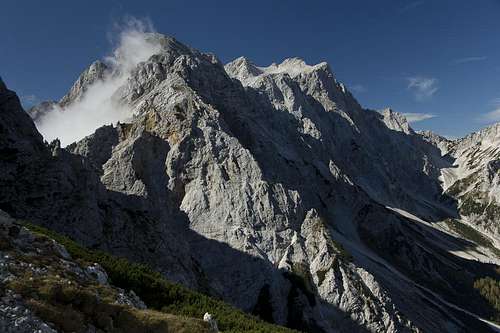
Turska gora is one of the central mountains in the main ridge of Kamnik and Savinja Alps. It's not among the highest and its neighbours are also more attractive mountaineering goals. But it has an important transition position, because the main marked trail in the massif crosses its summit. And also from the north, Turska gora offers a few nice ascents, also classical climbs.
A short geography
West of Turska gora the high karstic plateau of Mali podi lies. There is a new bivouac from which the ascent is short and easy. Towards the NW the main ridge of the massif comes from the group of Rinke. Between the last of them (Mala Rinka, 2289 m) and Turska gora there is a notch which from the north a nice couloir reaches. That is Turski žleb, an important passage, where also a marked, secured route is arranged. Then the ridge further up on Turska gora is flat and broad.
Further on towards the SE, a more rugged and sharp ridge descends. It reaches a picturesque notch, called Kotliči, 1974 m, separating Turska gora from the massif of Brana, 2253 m. The southern and western slopes are from the summit of Turska gora falling towards the end of Kamniška Bistrica valley, called there V Koncu (In the End). Those faces are quite steep and rocky on the top and rarely anyone climbs there. Below are steep ravines and grassy slopes, the ravine of Kotliči is bordering the area on the east.
A bit less steep ravine is reaching the Kotliči notch also from the north, from Okrešelj high basin. Between that ravine and Turski žleb couloir there is the Noth face of Turska gora. It is steep and rocky and three side ridges are descending from the main ridge down to Okrešelj high basin.
What To Do There?
First, many hikers are crossing Turska gora, so ascending its summit in a tour, combined with other goals. From the north climbers are reaching its summit by one of classical climbs, in summer conditions and in winter. For tour skiing, Turska gora is less popular, although it's possible to ski from its summit down to Mali podi and further down into Kamniška Bistrica and also down through Turski žleb.
Summit Views
Although some views are open also to more distant mountains, the most attractive views from Turska gora are on the higher neighbouring mountains.
Getting There
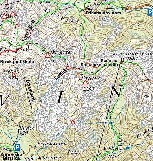
To ascend Turska gora, two main trailheads are used:
1. Kamniška Bistrica valley

Officially you should park at the mountain hut, 601 m, but recently (2019) the traffic sign for driving prohibition is turned around and many people are driving to the valley end - V Koncu (picture right). There you can park just past the lower station of material cable way for Cojzova koča, some 900 m.
If you go on top via Kamniško sedlo (saddle), you can drive from the hut in Kamniška Bistrica, 601 m, further on to the parking place Jermanca, 900 m. The road is at first the same as towards V Koncu, but soon you deter right.
2. Logarska dolina (valley)
We drive by the valley (entry with car is payable) till its end and park by the hut below Rinka waterfall (Koča pod slapom Rinka), 930 m. From there, we ascend to Okrešelj high basin (hut there) and choose one of the ascent options.
Ascent Routes
The ascents from both sides, south and north, can be combined into nice round tours.
1. Over Žmavčarji

This is a quite well beaten path, but not marked and not just trivial. For 1350 m we shall need some 4 h 15 min, on the Swiss Hiking Scale the difficulty would be T4.
From V Koncu parking place we continue by a cart-road, when it branches, we keep right. By a boulder, where our cart-road turns more towards the right, we leave it and continue straight by a path, which soon starts ascending steeply in switchbacks. Some exposed places are secured with a cable, but still require a safe step. So we cross the forrested ridge, coming down from the long ridge of Skuta (Veliki greben). On the other side is the steep slope of Žmavčarji. In good 1 h we reach out of woods, but the trail continues to ascend steeply. Where the grassy slopes are intermitted by rocks, short cables may help us again. On the left are the walls of Veliki greben. Higher, the path crosses steep scree fields and turns a bit left, into a steep, grassy valley. When we ascend through it, we are already on the high plateau of Mali podi. Following a weak trail and ciarns we keep right and soon reach the bivouac (bivak pod Skuto, 2072 m).
From the bivouac we continue by a weak, still not marked path which sticks to a small ridge. In 15 min we hit the marked path and continue by it right, towards Turska gora. In a slight descent it reaches first the exit of Turski žleb (couloir), there we continue straight and with a help of a few pegs soon reach the summit ridge and then the summit. Some 1 h from the bivouac.
2. From V Koncu over Kotliči ravine

This route is rarely done and is not recommended (I havn't done it). We start as described above in #1 and ascend till the middle of the slope of Žmavčarji. From there, on the altitude of some 1600 m, it's possible to cross the broad grassy slope towards the east. We cross below the rocks of Turska gora south wall, aiming towards the distinct Kotliči ravine. On many places some easy climbing (up to UIAA degree II) is needed, especially in the vicinity of the ravine. On the notch of Kotliči, we hit the marked path and turn left. As described by the route #3, we continue on top.
3. From Kamniško sedlo
The start of this route is Kamniško sedlo mountain hut (Koča na Kamniškem sedlu), 1865 m. From Jermanca parking place, 900 m, we reach it by a frequented, easy marked path in 2 h 30 min (from Koča v Kamniški Bistrici in 3 h 30 min).

From Kamniško sedlo (saddle), we continue by a good marked path westwards. On the first branching we keep left and cross the northern slopes of Brana. Over steep scree slopes we cross to the second branching, where we continue straight, towards the notch of Kotliči. After some more crossing, the path descends steeply (secured section) into the notch, 1974 m. Now the most beautiful and interesting part is awaiting us. A well secured and quite steep path is leading us towards the top. We climb through the so called "Sod brez dna" (Bottomless barrel), a natural window in the wall of Turska gora. After it the path gets less steep and by a panoramic ridge it continues on top. 2 h 15 min from Kamniško sedlo, difficulty T4.
4. From Frischauf hut via Turski žleb

Frischaufov dom (hut), 1393 m, stands in the beautiful high basin of Okrešelj. We reach it from the parking place in Logarska dolina (valley end), 930 m, by a good, frequented marked path, which passes the picturesque Rinka waterfall. 1 h 15 min till there.
From the meadow behind the hut we continue westwards (not southwards on Kamniško sedlo!), towards Savinjsko sedlo (saddle). Soon we reach the next path branching, where we turn left, following the inscriptions "Turski žleb". A steeper ascent brings us to the couloir entry. In snow conditions the couloir can be skied down (steep, 35 degrees), in summer, there's a danger of falling rocks (helmet!) and the path is also secured with cables. We keep by the right edge, higher we continue over a vertical wall by metal steps and then the ferrata crosses left. Also the last part of couloir is steep (gravel). As described in #1, we then continue left up on the summit ridge and on top. 3 h from the hut.
5. From Frischauf hut via Kamniško sedlo
From the hut on Okrešelj meadow we can also continue southwards, following the route on Kamniško sedlo. At first the marked trail is quite flat, then we scross screes and enter the rocky part. There the path is secured. Higher it crosses the screes again, climbs by an exposed ledge in the eastern direction and above brings us over grassy slopes on Kamniško sedlo. Left is 10 min to the hut, but we go right and ascend Turska gora as described under #3. From Frischauf hut 3 h 15 min.
6. From Frischauf hut directly on Kotliči
The route #5 goes very much around. On the place, where we are under the rocky walls of Brana, it's possible also to keep right and ascend by a steep, rocky ravine directly on Kotliči notch. But that's a pathless terrain and the ascent requires some easy climbing (I haven't done it).

|

|

|
Three classical climbs
|

|

|
Mountain Huts
The following three mountain huts and one bivouac are supporting the ascents on Turska gora:
- Dom v Kamniški bistrici, 601 m. Reachable by car.
- Koča na Kamniškem sedlu, 1865 m. 2 h 30 min from Jermanca parking place, 3 h 15 min from Dom v Kamniški Bistrici.
- Frischaufov dom (on Okrešelj), 1393 m. 1 h 15 min from Logarska dolina valley end.
- Bivak pod Skuto (on Mali podi plateau), 2072 m. From V Koncu parking place 3 h, from Dom v Kamniški Bistrici 4 h.
When to ascend?


Turska gora can be best ascended in summer conditions. That's from the end of June till the end of October (or first snow). That's for hikers, climbers can enjoy also classical climbs in winter conditions.
For tour skiing Turska gora is less popular, but possible. Some passages are rocky, steep, and require good conditions. Skiing towards the north, through Turski žleb, is very steep and further down, by the Rinka waterfall, the terrain is really not nice for skiing. But Okrešelj basin is wonderful for tour skiing. Skiing by the slope of Žmavčarji is also very steep and rarely has good snow conditions. Also the last part (around Veliki greben) is not nice for skiing. In normal winters, the best conditions would be in March and April.