Toggle navigation
Mountains
Routes
Images
Trip Reports
Forum
What's New
People
Areas & Ranges
Articles
Trailheads
Canyons
Huts & Campgrounds
Albums
Logistical Centers
Fact Sheets
Lists
Custom Objects
Gear
Plans & Partners
WELCOME TO SUMMITPOST
SIGN IN
REGISTER
Jbel Toubkal
Additional Parents
Ouanoukrim
High Atlas in November
Image
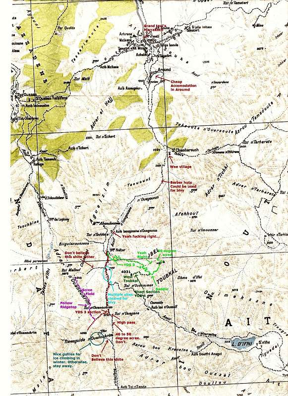
Toubkal map
View High-Resolution Image
Toubkal map
Updated Toubkal & Imlil Valley topographical map. Original is horribly erroneous. Done without permission of the Moroccan survey; so probably illegal. Use for climbing and hiking purposes only.
« PREV
NEXT »
Proterra
on
Nov 25, 2007 9:17 am
Comments & voting
Other parents
Lat/Lon:
31.06587°N / 7.92252°W
Image ID:
359667
13258 Hits
71.06
% Score
1
Votes
Log in to vote
Comments
No comments posted yet.
to post!
Don't have an account?
Jbel Toubkal
(Mountain/Rock)
« PREV
Viewing
#213 of 251
GALLERY
NEXT »
Proterra's Image Gallery
« PREV
Viewing
#168 of 260
GALLERY
NEXT »
Ouanoukrim
(Mountain/Rock)
Loading....
High Atlas in November
(Trip Report)
Loading....
×
You need to login in order to vote!
User Name
Password
Remember me
Forgot your password?
Log me out when I close my browser.
Keep me logged in all the time.
sign in as a user
Don't have an account?
Register now for FREE
Rating available
Suggested routes for you
People who climb the same things as you
Comments Available
Create Albums
Register Here


