Toggle navigation
Mountains
Routes
Images
Trip Reports
Forum
What's New
People
Areas & Ranges
Articles
Trailheads
Canyons
Huts & Campgrounds
Albums
Logistical Centers
Fact Sheets
Lists
Custom Objects
Gear
Plans & Partners
WELCOME TO SUMMITPOST
SIGN IN
REGISTER
Coeur d'Alene, Mount
Additional Parents
Image
Topo map of the Caribou Ridge...
View High-Resolution Image
Topo map of the Caribou Ridge...
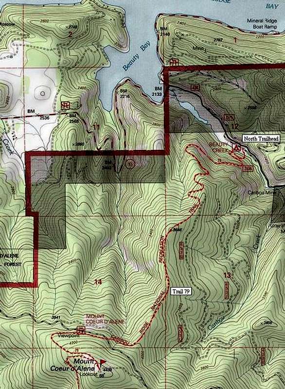
Topo map of the Caribou Ridge Trail 79 up Mount Coeur d'Alene (5 miles one-way). Note the dirt road access at the "Viewpoint" noted at the 4,000' elevation. A spur of this same road goes to the summit campsite.
« PREV
NEXT »
dluders
on
Apr 28, 2005 10:21 pm
Comments & voting
Other parents
Lat/Lon:
47.59400°N / 116.68°W
Image ID:
102862
4284 Hits
74.92
% Score
5
Votes
Log in to vote
Comments
No comments posted yet.
to post!
Don't have an account?
Coeur d'Alene, Mount
(Mountain/Rock)
« PREV
Viewing
#2 of 10
GALLERY
NEXT »
dluders's Image Gallery
« PREV
Viewing
#8 of 89
GALLERY
NEXT »
×
You need to login in order to vote!
User Name
Password
Remember me
Forgot your password?
Log me out when I close my browser.
Keep me logged in all the time.
sign in as a user
Don't have an account?
Register now for FREE
Rating available
Suggested routes for you
People who climb the same things as you
Comments Available
Create Albums
Register Here


