
Comments
No comments posted yet.
|
|
Trip Report |
|---|---|
|
|
48.71439°N / 121.4668°W |
|
|
May 21, 2013 |
|
|
Skiing |
|
|
Spring |
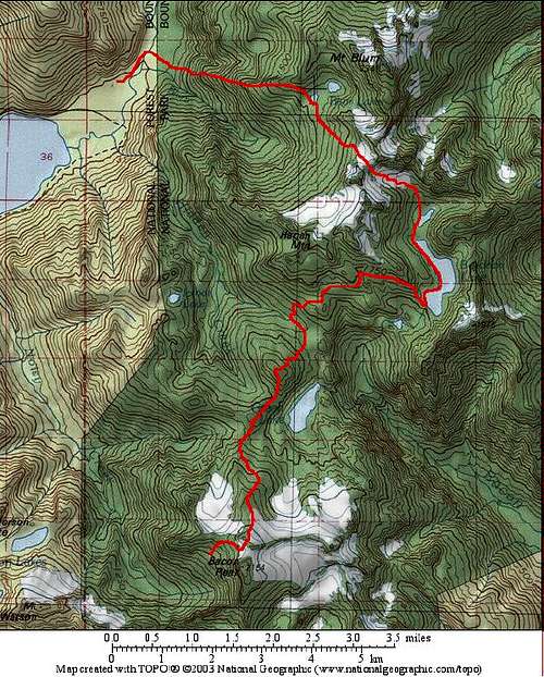
The wilderness of high basins and alpine ridges stretching from Mount Blum to Bacon Peak is unique in an area of unique places. Despite a collection of attractive open meadows, lakes, big waterfalls, and relatively easily traveled ridge lines and rocky peaks, there are no trails entering the place; all visits require cross-country travel skills. The long curving valley, almost a canyon or gorge, that encloses Lake Berdeen is especially intriguing as an un-trailed wild area. The area is seeing some limited summer visitation, but when snow covered it is as empty of humans as another planet.
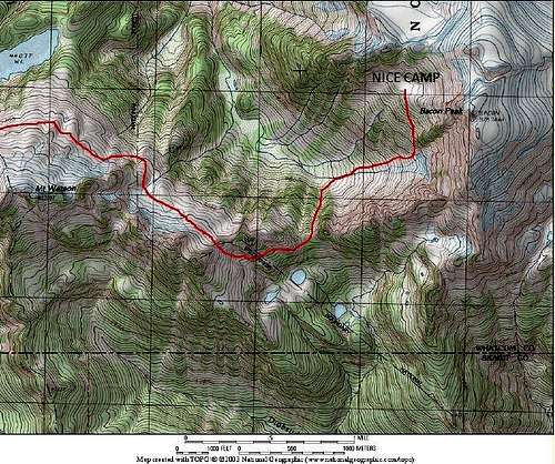
A few years ago I did a solo late May ski traverse from the Blum Lakes over Hagan ridge, down to Lake Berdeen, up and over Bacon Peak, then down the west face of Bacon, up and around the north side of Mount Watson, and then exited via the Anderson Lakes trailhead, getting back to the car via bicycle. It turned out to be perfect terrain for skis except for the start (which weeds out the undeserving) and the “yo-yo” between Bacon and Watson which requires some off-skis boot/crampon travel. My intent with this report is to provide useful route info for anyone inclined to give this one a try and ski into this fantastic place.
Details: After stashing my bike at the snowline at about 3400 feet on the Anderson/Watson Lakes trailhead road, I drove to the very end of the Baker Lake road, and set off down the trail with skis on the pack. It was warm and sunny, summer-like, probably making the few other hikers loitering in the area wonder if I was insane. After crossing the huge bridge over the Baker River, I immediately left the trail, stepping into thick temperate rain forest. Devil’s club, vine maple, and a whole host of other botanical specimens conspired to make travel moderately difficult, especially for a guy with a heavy pack with skis on top. As the land tilted upward, gravity joined the conspiracy. But stubbornness and a lack of common sense prevailed, and after 8 hours of dizzying work gaining over 4000 feet, I found myself at the lower Blum Lake where camp was established. Even though I hadn’t hit snow until above 4200 feet, and continuous snow only started at about 4500, the snow was suddenly quite deep once back at the lakes, probably averaging ten feet or more. All in all, the trail-less trip up the side of Blum went easier than some North Cascades bushwhacks, I was surprised the brush wasn’t heavier this far west in the range.
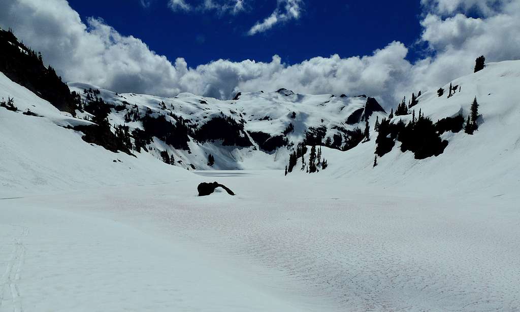
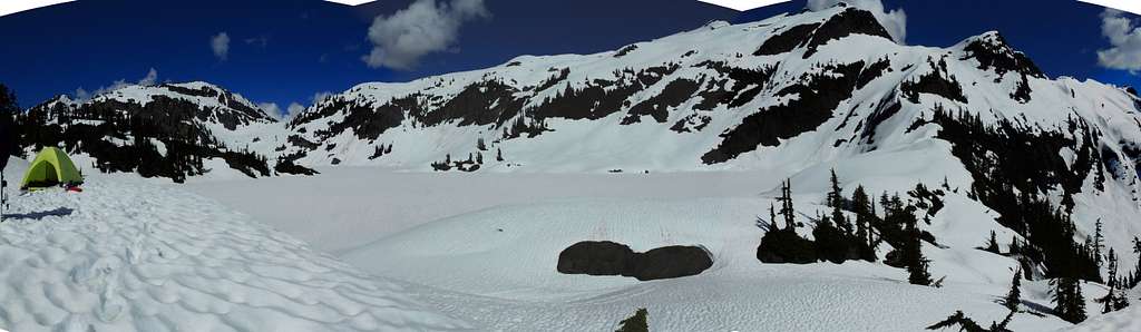
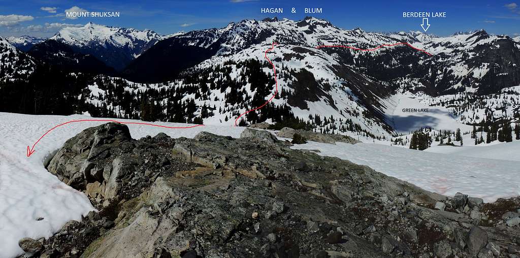
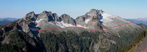
On day two climbing skins made easy work ascending to the ridge between Hagan and Blum Peaks. I found it straightforward to first traverse southward nearly level from the lower lake, then turn uphill on the obvious lower angle terrain up to the ridge. I had planned on skiing up Mount Blum, but upon gaining the ridge line I became concerned about several factors: Despite my being in sunshine at the moment, there were thick clouds scraping over the summits to the south and headed in my direction (see main photo), possible avalanche conditions once the brilliant sun warmed the steep slopes into Berdeen gorge further (again, see same photo). Plus, this was the beginning of a wilderness ski route I had never done nor ever read anything about, so my focus was on getting through. (Turned out I should not have been concerned about time). So I searched out the best slot down into the Berdeen gorge and headed down. The first 200 feet of snow were already sun-warmed and deep, so I boot cramponed down, then put skis back on to traverse cautiously between avalanche tracks down to more reasonable terrain. Then I enjoyed a relaxed cruising descent all the way to the valley bottom.
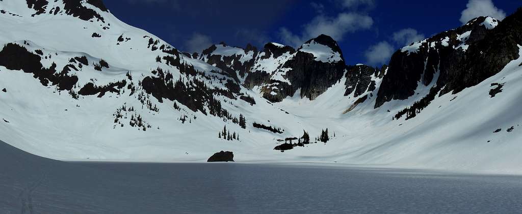
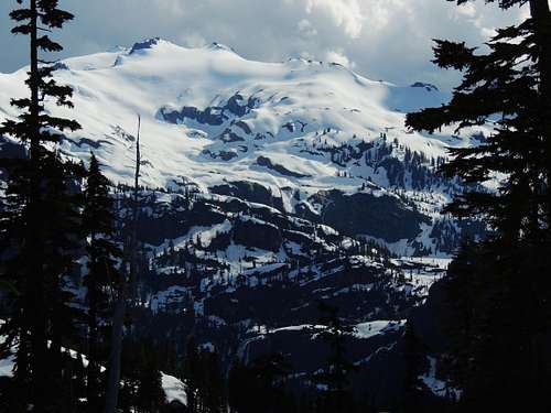
Eventually I arrived at the south end of Lake Berdeen, where the valley floor drops away so ruggedly that one cannot see the bottom from the lake end. The outflow river from Lake Berdeen drops in a large waterfall. Across the valley at the base of huge, glacier covered Bacon Peak, the outflow from Green Lake pours in a humungous waterfall into a branch of this same gorge. This was too wonderful to hurry past, so even though it was early afternoon I made camp, just to be able to linger and soak in the place. It was truly hypnotic, quiet and peaceful while being visually chaotic.
The high volume waterfall from Green Lake across the gorge made me concerned that I would not be able to cross the outflow river, so I altered plans to access Bacon Peak by instead staying on the connecting ridge to the west of Green Lake; this meant more work, going up and down over hills on the ridgetop. But it went smoothly, only had to remove the skis in a few short spots: a couple of places getting down through small cliffs, and at one spot over the higher “hill” that measures out at 5560 I downclimbed some rock on the south side.
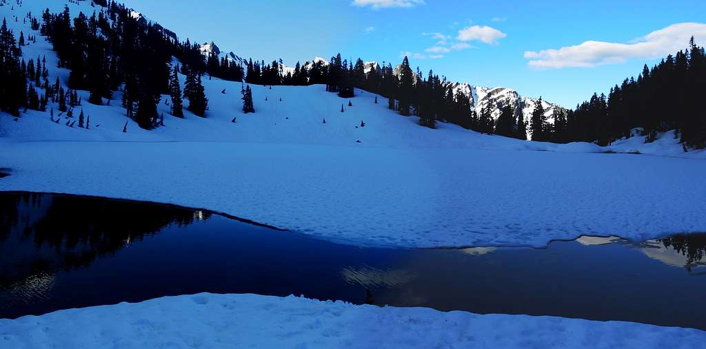
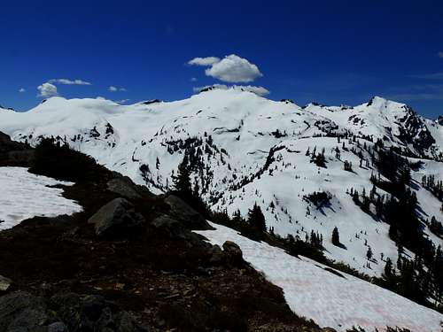
It turned out I could have skied to the west end of this hill and found a ski route down, but I couldn’t see this until after. Although a reasonable route, the exploring and occasional backtracking I did to work it out was time-consuming. By the time I formally started up Bacon Peak it was early afternoon and wonderfully sunny and warm, so I succumbed to my base instinct to go slow and absorb experiences (aka being a lazy bastard), and set another camp on the shelf at 5680 that the maps show contains a few tiny tarns. Also factoring in heavily in this decision: One of these tarns had melted out just enough to show an easily accessible pool of clear, blue, delicious water, too tempting to pass up on a trip that might involve melting snow at other camps. Besides, the view of the Pickets and other great North Cascades places was too good to race past. I just had to spend an afternoon sitting on sun-warmed rocks, drinking quarts of that delicious water, marveling that I could be doing such while on a ski trip.
Of course, there is a risk to a go-slow, casual attitude: weather. The next morning my clear skies were gone; I skied up the glacier on Bacon Peak’s northeast side while watching curtains of rain fall in various directions. But my luck held, I skinned up to the summit area without suffering any direct rain hits. For a mountain that barely rises over 7 thousand feet, Bacon sure feels higher, probably due to its vast size; the extensive snow covered plateau it forms makes one feel like you are on a bigger peak. I went west of Bacon’s sub-summit, point 6960, downclimbed about 20 feet of rock, then put skis back on for a short descent to the hanging basin at 5700. Then bearing skiers left, the slope provided a manageable straight descent on snow to the valley bottom. The initial slope was smooth snow, but nearing the valley bottom the slope was buried deep in jumbled up frozen blocks of dirty snow, impossible to ski, but reasonable to boot over. This was old avalanche debris from the nearly 2000 foot tall vertical west face of Bacon Peak. As I traveled, a serac broke loose above, raining thunder and debris, but was never close enough to be a danger, just spectacular to watch. Bottoming out at 4000 feet, I immediately turned uphill and boot cramponed back up the other side of the valley, topping the ridge at 4900 feet. Turning west, I cramponed along tilted shelves on the south side of this ridge in forest until reaching the 5360 pass leading onto Watson’s north slope, then it was back on skis to enjoy pleasant wide-open alpine cruising.
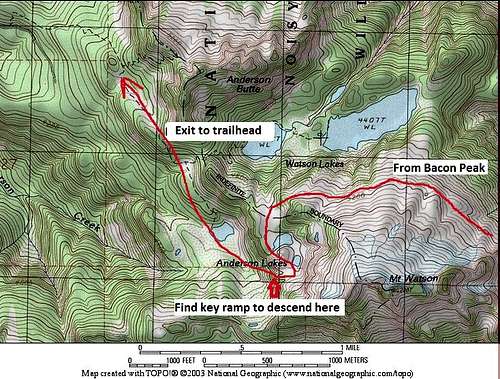
The north slope of Watson seems made for skis, smooth snowy slopes interwoven with varying degrees of steepness allow the explorer to choose wherever they wish to wander. During the traverse one does have to drop below 5000 feet to get around a buttress, but this is easily navigated. Back up at about 5100 feet the slope quite easily circles around to the upper Anderson Lakes. I set another camp here in preparation for the final day getting back to the car.
The downside to crossing over into the Anderson Lakes area is that, once leaving the north side of Watson, one exits the established wilderness area, so the snow is suddenly overrun with snowmobile tracks. Guess one has to tolerate the machine dependent motor heads when getting back closer to civilization. Of course, I saw no snowmobiles this late in the season, just very old tracks everywhere.
The final day presented an obstacle I wasn’t expecting. Between the upper Anderson Lakes shelf and the lower lake and trail system, there is a 400 foot tall cliff running northwest to southeast. Having traveled through here many years ago in summer conditions on the way to summit Bacon peak, I had vague recollections of getting around this at the northwest end, scrambling up exposed but easy rock. But when I skied over there, deep snow ending in apparent drops made any descent there look deadly. I turned and skied the length of the cliff, stopping occasionally to consider various slots down through the woods; they all ended in vertical drop offs.
Finally, at the far southeast end where the cliff ran up against the west side of Mount Watson, I found a tilted snow ramp down through the trees to lower Anderson Lake. Now the way out was clear, skiing past the last lake, a few open meadows, then working out the maze of logging roads and snowmobile tracks down to the last of snow. The snow ran out pretty much all at once, making for a convenient transition to walking, and even that lasted only a few hundred yards until I came to the place my bike was stashed. Then a fast, thousands of feet downhill bike ride got me to the Baker Lake road, and another couple of hours back to my car at the north end of Baker Lake, done! Five days, almost perfect weather, not a single other human sighted, not even tracks (until back at the Anderson Lakes area as noted above… then it’s snowmobile hell).
There are several on-line trip reports about summer scrambling and climbing in this area, but I have never read anything about anyone doing this one-way ski traverse as described, so I am curious if this might be a first.