

-
 42728 Hits
-
 86.78% Score
-
 23 Votes
|
|
Route |
|---|---|
|
|
46.29480°N / 9.58610°E |
|
|
Mountaineering, Trad Climbing |
|
|
Most of a day |
|
|
S-, III to IV with places of IV+ or V- |
|
|
Overview
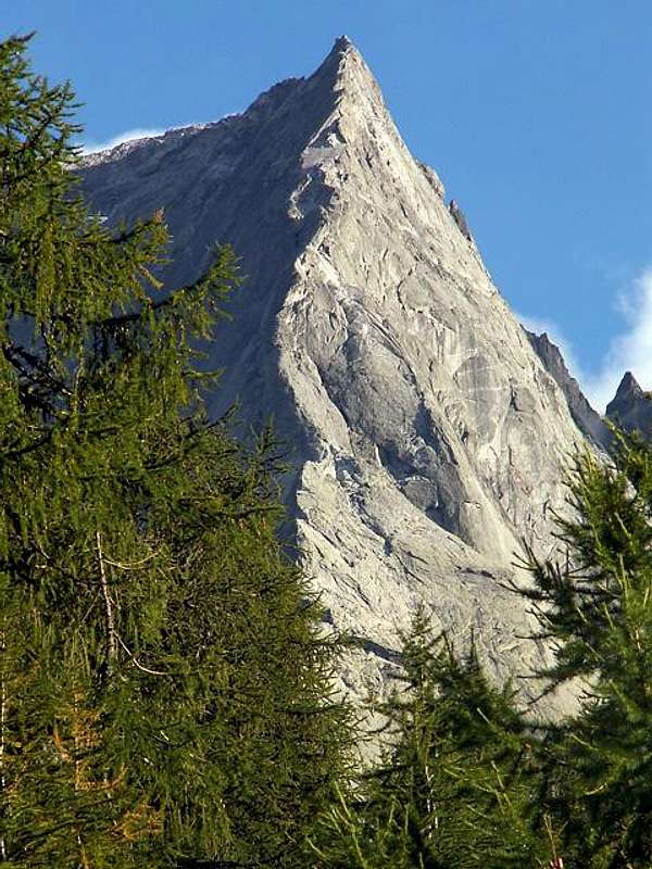 The route follows the line between sun and shade. Photo by quota3841
The Nordkante (North Ridge) of Pizzo Badile is often referred to as one of the finest rock climbs of its grade in the Alps. The German term "kante" better describes this generally extremely steep ridge as a "corner" or "edge" between two steep faces. Sometimes it is simply referred to as the Badilekante.
The technical part of the ridge rises about 700 m (2,300 feet) yielding about 1,000 m (3,280 feet) of climbing which is mostly UIAA III to IV with at least two places of IV+ (YDS about 5.2 to 5.7). Several years ago, a rock fall took away one of the IV+ places. Most consider the "new pitch" to also be IV+, but some grade it at V-.
The climbing is wonderfully clean and exposed with fine views across the NE Face to the Cassin Route. Guide Christian Klucker who had made the first ascents of both the East and West Ridges earlier made the first known attempt on the Nordkante July 11, 1892. He reached the lower crux area now known as the Zürcherplatte (30 m of IV+) and retreated from there. He was climbing solo and scouting the route for a possible climb with a client.
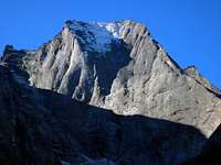 From the NE.
Another attempt was not made until July 1911 when the Italian brothers A. and R. Caligari along with guide G. Scotti failed to get any higher than Klucker. They returned in August of 1911 and lowered one person down the pitch on a long rope.
He then climbed back up the pitch with a top rope and finished "an ascent" properly disregarded by nearly everyone. Alfred Zürcher with guide Walter Risch made the first complete ascent of the ridge by fair means in 1923 . Zürcher was also on the first ascent of the Lauper Route on the Eiger. The first winter ascent was made February 20 - 21, 1964 by Aldo Anghileri, Casimiro Ferrari, and Giuseppe Negri.
Approach
The best approach is from the Sasc Furä Hut (see main page for hut approach and more links) via a good climber's trail - about 1.5 hours from the hut to the start of the climb.
Route Description
The route essentially follows the ridge crest from the base to the summit with all detours to avoid extreme difficulties being made to the climber's right except for one 10 m detour onto the NE face in the upper part of the climb. Most belay stances are fixed and there are varying amounts of fixed protection on the route making it relatively easy to follow. Times given range from 3 hours for a very fast party (like with a guide) up to 7 or 8 hours, but many people take longer and the bivouac hut on the summit is used frequently. In poor weather the ridge is very exposed to wind and precipitation, the lightning hazard is extreme and the rock can verglas very quickly. Descending the ridge is not something done quickly and upward progress can be extremely difficult in these conditions. Fatalities from exposure have not been uncommon.
 |
 |
 |
 |
 |
More climbing photos
 |
 |
Descent
The technical difficulties do not end upon reaching the summit of Badile. Now one must descend. The easiest, most preferred, and most recommended descent route is the South Ridge. This is great if the climb started in Italy, however if one climbed a north side route and has a need to return to the Swiss side of the mountain, it will almost certainly require an overnight stay in the Gianetti Hut and then take most of a day to return to Switzerland. The route down the South Ridge itself is not necessarily easy to find if one did not ascend that way. Difficulties have been reported (see below for my personal report).
The return to the huts on the Swiss side is normally made via either the Passo di Bondo (3169 m) which requires glacier travel on the Swiss side and brings one first to the Scioria Hut or via the Passo Della Trubinasca (2703 m) which brings one to the Sasc Furä Hut. There is a loose and often icy couloir on the north side of this pass frequently requiring an ice ax and crampons. If there is not a need to return to one of the Swiss huts, one can hike out to Bagni de Masino and obtain public transportation from there. It is recommended that schedules be checked in advance.
The bus schedule has not been ideal in the past. It is apparently possible to arrange for a taxi by calling from the Gianetti Hut. It is entirely possible to descend the North Ridge (Nordkante) and many parties do so. But this is a quite long and demanding descent requiring many rappels. Parties do run out of daylight and have to bivouac. Descending the Nordkante is not a decision to be made lightly. A couple of personal experiences: alpenkalb (Rolf) reports ( in 1958): Many people chose the way to the Italian Capanna Badile (2534 m); stay there overnight and return to Switzerland the next day via Passo di Bondo. This, however, may not be the best choice, because there are too many cairns on the way down, which is very misleading.
I remember a French climber who was very upset about that, looking for the way and cried Merde! We talked to each other, it was Lionel Terray, and we headed safely to the very expensive hut. It might be a good idea to descend the Nordkante instead. Fred & Moni's experience (1985): We failed to find the easy way down the South Ridge and instead ended up on a rappel route down what seemed to be the steepest part of the southwest face. This worked out fine, but was not what we had planned on. We did not have any trouble finding the Gianetti Hut (formerly Capanna Badile referred to by Rolf) as it was clearly visible from our descent - we just traveled to it straight cross-country. This would not be so simple in the fog or darkness.
The hut warden was great and fed us a tasty minestrone even though we arrived more at bedtime than dinnertime. We did not find the hut to be expensive. We planned to return to Switzerland via public transportation since our English language guidebook stated that there was regular bus service. It turned out that it was "regular" but only twice a day - once early in the morning and once late in the evening. The late bus was too late to make train connections to Switzerland! Fortunately, we were staying with friends in Sils Maria and they "rescued" us with their car.
Essential Gear
Most parties will be most comfortable with a full rack as the amount of fixed protection varies and some points may be further apart than some might like. A 40 or 45 m rope is adequate, but a 50 m rope would be better if rappelling off. Depending on the route of return, an ice ax and crampons may be needed. If the weather is looking threatening these may be wanted in any case.
Links to other's route descriptions, trip reports, photos, etc.
A good route page (in German) Styria Alpin Climberland – an excellent slide show of the Nordkante including several videos This is the website of SP member Lorenz