

-
 14257 Hits
-
 74.66% Score
-
 5 Votes
|
|
Route |
|---|---|
|
|
16.62959°S / 67.79661°W |
|
|
Basic snow, glacier climb, some ice |
|
|
A few days |
|
|
USA II/PD/50 degrees |
|
|
Overview
Nevado Illimani 6438 m is a majestic peak belonging to the Cordillera Real. It's the highest mountain of the Cordillera Real and the second highest one of the whole Bolivia, after Nevado Sajama. Illimani counts four main summits: Pico del Indio 6109 m, Pico Norte 6403 m, Pico Central 6362 m and Pico Sur 6438 m, the highest one. Pico Sur is climbed via the Normal route, Grade II (PD) with some 50 degree ice/snow, starting from the Nido de Condores and running along the SW ridge. To get there, from Puente Roto area follow a road next to the mountainside and then aim for the rock ridge that is connected to the summit (Pico Sur). Get on the ridge and follow it until you get to the Nido de Condores (5,450Mts) flat. You may see other camping areas below this point but it's recommended to get to the Nido de Condores and start you final assault from here, since the elevation gain from it is about 1000 meters.
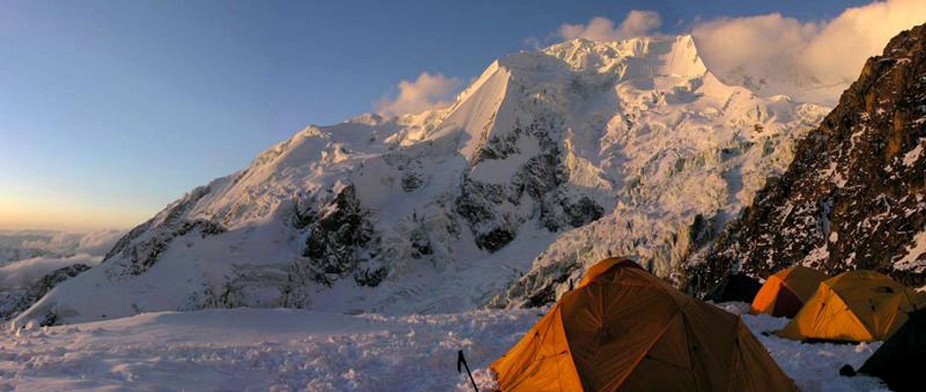
To get there, from Puente Roto area follow a road next to the mountainside and then aim for the rock ridge that is connected to the summit (Pico Sur). Get on the ridge and follow it until you get to the Nido de Condores (5,450Mts) flat. You may see other camping areas below this point but it's recommended to get to the Nido de Condores and start you final assault from here, since the elevation gain from it is about 1000 meters.
Approach
The approach to the Illimani starts from the La Paz. There are two basic approaches to the West side, via Pinaya and via Cohoni and both will take you to Puente Roto, the place where it's convenient to arrange the Base Camp.
Approach via Pinaya: i will describe this one I know about which, the most popular, and give some hints about the second one, and alternative approach. The approach is via the villages of Pinaya or Estancia Una. From La Paz you can arrive by car to Pinaya, a rural village and very small, located on the slopes of this great massif at 3,700 meters above sea level, in about 3 to 4 hours by 4x4 vehicle, depending on the conditions of the road (ask first). The trip can be very expensive, but it's understandable since the road and the distance is huge, although you may feel you can touch the mountain with your hands from La Paz.
There is also a bus service to near town called Quilihuaya, but them you will have to walk two ours in direction to Estancia Una. The bus can be found near the Mercado Rodriguez (market) at around 5:00 AM. Please ask for the bus BEFORE you go there because schedules change, as well as the roads may not be accessible. If you want you can share your expenses with other climbers. You will find them everywhere, but you can also hang out in the Hotel Torino, downtown La Paz, and try to find other climbers aiming to climb Illimani. Another good place to hang out and meet climbers, used to be the Restaurant Mongos. When you arrive in Pinaya, you can rent donkeys for the approach to the bottom of the valley, where the Base Camp is located. This place is called Puente Roto, at an altitude of 4,400 meters. The walk of these 8 km takes from 3 to 4 hours. Also in Estancia Una you can hire donkeys, for a service that will take you to the Puente Roto.
From Pinaya walk towards the massif, following the rough path to Puente Roto 4400 m. of altitude. You have to hike for another 10-25 minutes towards the West face of the Illimani to a flat meadow with a stream that allows to put a very nice camp. There is a rough miners road just above the meadow. Porters can be arranged from here to go to the high camp. To get to the high camp, follow the miners road for 15 minutes before heading left for the obvious scree slope that leads to the rock ridge leading down from Pico Sur. Join the ridge and walk up to Nido de Condores (5450m, 4-6hrs, no running water but next to glacier).
Approach via Cohoni: by bus from La Paz to Cohini, available at the San Pedro district , calle Luis Lara and Calle Boqueron. Please check schedule and availability. You probably will have to get to the area and ask. The trip takes about 5 hours. The following is the description of this approach, taken from Yosi Brain’s Guide Book: From Cohini, follow a road toward La Paz, and then follow a path that will take you to the right. After half hour you will see the west side of Illimani. Continue on the path until joining the river Huascanasca and eventually you will arrive to Puente Roto. Please check Brain’s guide for more details or ask locals.
You can use porters or “cholitas” (Native Bolivian women from the country side) from Puente Roto. Running water may not be available but snow is available with the possibility of melting it.
Route Description
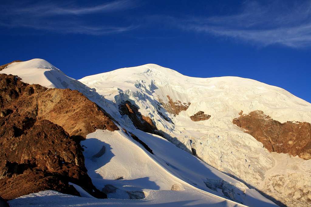
From Nido de Condores climb the ridge, and be sure to negotiate crevasses carefully. You will approach an ice wall/crevasse or a bergshrund if you let me called like that, which can be somehow crossed on the left side, and then keep going an steep section towards the right.
This step has been reported to be complicated (Sept. 2005). Climbers informed that the bergschrund is now a big overhanging wall. Inform yourself about this part before attemting the mountain, because the combination of altitude and fatigue can be a bog challenge.
You will arrive at a false summit, so now you will have to go toward the right an then follow a ridge toward the south, finally arriving at the Pico Sur.
It took me about 9 hours to climb the route, but I was going slow since I was very out of shape. My partners Gert-Jan Van Wijk and Manoilo Ventura had a lot of pacience with me…Normally is a 5-7 hours climb. The decent is shorter and rather faster (be carefully with the crevasse!) and it takes about 3 hours to Nido de Condores, and from here down the ridge another 2 hours to Puente Roto.
Essential Gear
Basic glacier and snow travel gear: crampons, ice ixe and a picket. One ice screw and rope very recomended.
Also, if the rimaye or bergschrund described for in the Route Description section is verz hard and technical, you may need more screws to pass that feature.
Red Tape
No fees no permits required
When to climb
The best time to climb in the Cordillera Real is between May and September/October, when the weather is dry. Usually June, July and August are the best months anyhow. This period is the Bolivian winter, which is dry and when normally the weather is quite stable. Possible some fresh snowfalls sometimes. The wind starts in July and as the season progresses more crevasses appear in the glaciers and the penitents in the snow grow. November to March, the temperature is higher, but the rain will make any climb unpleasant and dangerous, since the coctail of hot weather plus rain plus snow is not very appealing.
Camping
Camping is possible and there are no fees that I know about.
Meteo
Miscellaneous Info
More Information about Bolivia:
The US University of Massachusets Geosciences Group