
-
 34339 Hits
-
 75.81% Score
-
 6 Votes
|
|
Route |
|---|---|
|
|
46.24225°N / 9.62027°E |
|
|
scramble |
|
|
A few days |
|
|
walk up |
|
|
Overview
"Sentiero Roma" is one of the most classic route in the central alps. May be one of the finest.It tooks 5 or 6 days in both direction and it is placed on the south side of Val Masino Alps, and also it gives the opportunity to view all of them from lago di Novate Mezzola to Monte Disgrazia.
It is not advisable to attempt the route before july. All the passes with relatives chains are usually covered of snow.
Several huts and bivouacs are placed along the route. And they permit to divide the route in many solutions.
The approach
Hikers use to make the route from west to east. So the path start from the village of Novate Mezzola (316m) at the begin of Val Chiavenna (reached from Milan and Sondrio by car bus and rail).
For more enquires about this area, just check the main page of Val Masino Alps Val Masino Alps.
Route Description
First day:As i said, Sentiero Roma start from the small village of Novate Mezzola (317 slm).
A very simple way takes in two hours to the small hamlet of Codera (825m) in the omonimous valley.
Codera is one of the few villages in Italy than cannot be reached by cars. So it's advisable to spent time to visit it.
The path goes up through the valley, passing by Alpe Bresciadega till the ref. Brasca (1304 slm).
In the nearby the private ref.Bresciadega is also a good place for rest.
 |  |  |
Second day:
From ref.Brasca to ref.Gianetti (2534 slm).
This second part is quite mere difficult than the previous. The approach to Passo Barbacan (2598m) that permits to get the Val Porcellizzo, is infact long and steep.
Passo Ligoncio (2557m) could be even useful to reach the same point, if someone want to visit the Ref.Omio. In this case the route will be little bit longer.
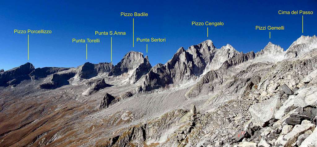
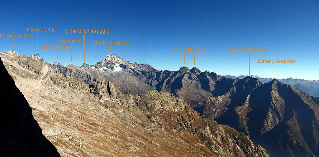
The summits at the head of Val Porcellizzo
The east section of Val Porcellizzo with the major peaks.
Third day:
From rif. Gianetti to Rif Allievi.
The distance is almost the same of the day before but longer in time. There are two passes to be crossed: passo del Camerozzo (2765) and passo Qualido (2540 m).
Some chains helps in those difficult passages. Pay attention if snow of late spring still remains in the couloirs.
The passes divides three valleys that belong to Val di Mello: Val del Ferro, val Qualido e valle Zocca. The Val del Ferro, which is the biggest, also hosts the bivouac Molteni/Valsecchi (2510m).
The view of all the sumits of the chain is amazing. From the ref.Allievi to the Cima di Zocca and the south wall of Punta Allievi is perhaps the most spactacular.
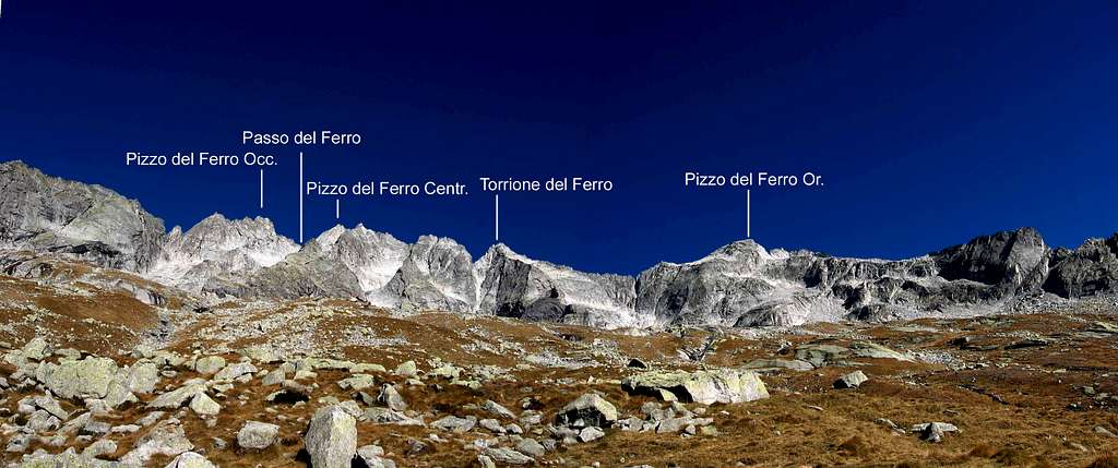
The summits at the head of Val del Ferro
Fourth day:
From rif. Allievi to rif. Ponti.
The longest stage. Easy path goes towards valle di Preda Rossa placed at the foot of Monte Disgrazia, across Passo del Torrone (2518 slm) first and than passo del Cameraccio (2950 slm).
Along the route, 2 bivouacs are good point for rests. They are the biv. Manzi (2538m) and biv. Kima.
Preda rossa is the valley where the Sentiero Roma finish. However is possible to contine the tour across the passo di Corna Rossa (2890m) towards the Valmalenco.
So spend the last day to go down to the valley towards Valtellina.
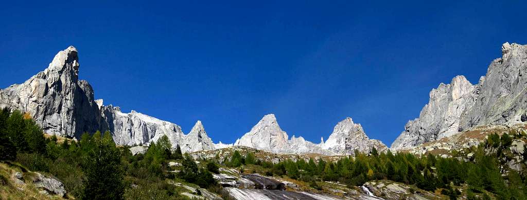
The summits at the head of Val Torrone
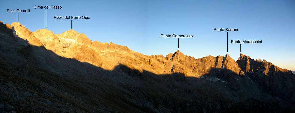
The summits of Val del Ferro and Val di Mello,seen from Passo del Camerozzo.
FIRST DAY: From Novate Mezzola(Val Codera)- rif. Brasca 1000m drop 4/4.30h (difficult E)
SECOND DAY: From ref. Brasca - passo Barbacan - ref. Gianetti 1290 m drop 6.00h (difficult EE)
THIRD DAY: From ref. Gianetti - passo del Camerozzo - passo Qualido - ref. Allievi 450m 5h (difficult EE)
FOURTH DAY: From ref. Allievi - passo del Torrone - passo del Cameraccio - ref. Ponti 1100m 6.30h (difficult EE)
FIFTH DAY: From ref. Ponti - village of Cataeggio (Valmasino) 1600m 3.00h (difficult E)
self made outline of Sentiero...
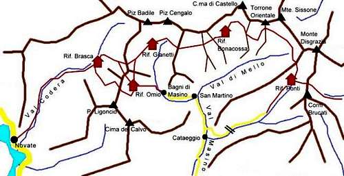
Refuges and Bivacs
rifugio Brasca: 1304m Alpe Codera, Val Codera CAI Milano tel.02/86463516 E-mail cai.milano@tiscalinet.itTel. 339/7176620 0343/63077
Places 48 No winter room open summer
rifugio Gianetti: 2534m Alta Val Porcellizzo CAI Milano tel.0342-64.51.61 92 places/12 winter open summer
rifugio Omio: 2100m Val Porcellizzo SEM Mliano tel.0342-64.00.20
47 places/9 winter open summer
rifugio Bonacossa/Allievi: 2385m Valle di Zocca CAI Milano tel.0342-61.42.00. 100 places/8 winter open summer
bivacco Molteni/Valsecchi: 2510m Valle del Ferro CAI Milano 12 places
bivacco Manzi/Pirotta: 2538m Val Torrone CAI Milano 12 places
rifugio Ponti: 2559m Valle di Predarossa CAI Milano tel.0342-61.14.55
85 places/20 winter open summer


