
-
 7017 Hits
-
 73.06% Score
-
 3 Votes
|
|
Route |
|---|---|
|
|
Mountain Bike |
|
|
Summer, Fall |
|
|
One to two days |
|
|
Medium hard bike tour |
|
|
Approach
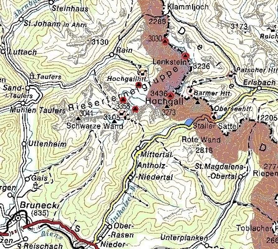
How to get to Staller Sattel / Passo Stalle or Bruneck/Brunico see the main page.
Overview
This is one of the most beautiful two-day bike tours in Hohe Tauern. Combined with the summit of Am Hengst, 2462 m, or even Dreieckspitze, 3030 m it offers you a wonderful mountain experience.
Only driving by bike down from Klammljoch / Passo di Gola, 2288 m, to Bruneck / Brunico, 835 m, means whole 1620 meters of heigth difference. Of course, this elevation must be also done upwards - or may be also not. With some logistics, you can use two cars and make the ascent from Bruneck to Staller Sattel by car. We did so.
The logistics was a bit annoying (because of limited traffic over Staller Sattel), but on the other hand we avoided busy roads in Pustertal and the ascent up on 2050 m. I shall describe this option. For sleeping I recommend the upper part of Defreggental (Arvental). This can be Patscher Huette, 1685 m, but much more beautiful is to drive further up the valley and sleep in a tent. OK let's go from start. We were four and had two cars, able to carry four bikes each...
Route Description - Day 1


Heigths: Up: 330 m, down: 500 m.
You can start in the afternoon. Leave one car in Bruneck and drive with all equipment up to Staller Sattel, 2050 m. Leave the other car there and start the 2-day tour.
At the beginning it goes down like a hell. Good asphalt road brings you 500 m down to Erlsbach, 1549 m in minutes! On the crossroads, turn left into inner Defreggental. The road becomes macadam, not too steep, you ride by a beautiful mountain creek. Pass the Patscher Huette, 1685 m, and continue to Obehausalm, 1793 m. If it's evening, you will meet less and less people. Continue to Seebachalm, 1879 m and pass it. Now you're more or less alone. Find a nice place by the creek and set up a tent.
Route Description - Day 2
Heigths: Up: 420 m, down: 1620 m.


Continue up the beautiful valley. It soon divides, the only possibility to continue is left into Arvental. After a short steeper part you reach the beautiful Jagdhausalm, 2090 m. A picturesque group of shepards huts lies beyond the creek and the long, flat valley is seen before you. You easily cycle up till the point of 2190 m, where the road turns sharp left and becomes steeper. Although a mountain bike is good, it is not the must. Put last efforts into the ascent and reach the highest point of cycling tour, Klammljoch / Passo di Gola, 2288 m.


Now you might want to stretch your legs a bit. Ascend over nice grassy slopes the summit of Am Hengst, 2462 m and enjoy panorama. Now the most probable option is to bike all the way down to Bruneck / Brunico. That means 1620 meters down! But if you are more in a mountaineering mode, you can reach also Dreieckspitze, 3030 m. The marked path should start on 2200 m (below the lake), should cross the valley (towards the south), reach Dreieckspitze west ridge and soon after the summit. The ascent should take some two hours (but we didn't do it).


From the saddle a just appropriate steep macadam road takes you down into Knuttental. Here you will probably start meeting first hikers. Take care of them and just enjoy riding down! The lower part of the valley is not so steep and you comfortably reach Rain, 1596 m. Take a look around! From Rain a good asphalt road leads you down the valley. Just enjoy! Before Sand in Taufers / Campo Tures there are beautiful waterfalls. You can park bikes on the upper part and take a marked path down. Viewing waterfalls and the chapel might take you some two hours.

When you proceed, you reach the picturesque Sand in Taufers / Campo Tures, 874 m in minutes. Above the town a big castle closes the whole valley. If you have time, go up an visit it. The rest of the tour towards Bruneck / Brunico you ride through a flat valley (you lose only 40 m) - just towards the sun, so it takes some additional effort. Now you have the other car up on Staller Sattel, 2050 m. Drive by car simply up and finish the tour. If you're a real bike monster, you can do this ascent also with bike. In that case also plan accordingly, and you don't need the whole logistics with two cars. But the traffic in Pustertal is quite dense (I think only in the beginning you can avoid the main road), and the altitude difference is considerable (1215 m).
Essential Gear
Mountain bike or a good travel bike.
Usual hiking gear.