
-
 8789 Hits
-
 76.66% Score
-
 7 Votes
|
|
Route |
|---|---|
|
|
46.43600°N / 13.43630°E |
|
|
Mountaineering, Scrambling |
|
|
Summer, Fall |
|
|
Most of a day |
|
|
UIAA I.-II. |
|
|
Class 4 |
|
|
Introduction
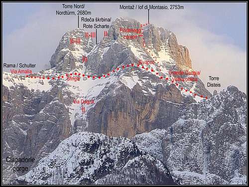
The ascent of the first climbers on Montaž is a great combination of a nice hike, crossing the mighty west wall by a picturesque ledge and easy climbing by a steep ravine. Actually the Findenegg route is ony the upper part, above Bivouac Suringar, and, strictly speaking, also the approach by the big ledge from Forca del Disteis. A beautiful combination from the south is the ascent over the Findenegg route and the descent over the normal, south route (see the description in the opposite direction). The Suringar bivouac can also be reached from the north (Via Amalia), and by the Western route, but those two ascents are much longer and higher.General Information

Orientation: No problems till the bivouac, later you carefully follow the marks in order not to climb into more difficult terrain. Map to be recommended: Tabacco No. 18. 1:25000.
Exposition: Some places are very exposed, so the tour is not appropriate for people suffering from vertigo.
Objective dangers: In the ravine, the usual care is needed regarding falling rocks. Snow on the big ledge in early summer can be dangerous too. And never go on this tour in danger of storm and lightning (the summit ridge and the descent by the east ridge)!
Best season: Summer months, normally from July till October (or first snow).
Gear: Good shoes and poles, for less experienced a short rope (20 m) might be useful.
Tour start: The end of the road on Malga Pecol, Altipiano del Montasio, 1520 m (reachable from Sella Nevea). See more about the approach on the parent page!
Highest point: 2754 m.
Altitude to overcome: cca 1250 m.
Time for ascent: 4 h.
Mountain huts and bivouacs: Rif. Brazza (1660 m) on Altipiano del Montasio and Bivouac Suringar, 2430 m, on the big ledge in the west wall.
Route Description
The upper part
From Forca del Disteis we must find (it is marked) the enter on a system of bands, leading into the south-west wall of Montaž. We first cross the start of a ravine, which disappears below us in the depths of the wild Clapadorie gorge, then we climb up (degree I). Soon we reach the foot of a high, remarkable tower (Torre Disteis), guarding the continuation of bands. Beyond it, the bands broaden and by a comfortable ledge, going horizontally above the completely vertical walls, we walk on some sections with hands in pockets, on others by narrow and exposed ledges to the Suringar bivouac (2430 m).
 |  |

 |  |
An Intermezzo From Skiers...
Here, I'd like to share with you some beautiful points from the web diary of Marijana Cuderman & Marko Kern, from the winter tour in which Marko was skiing down the Findenegg couloir:Resnično zanimiv pa je sam prestop okoli robu, ki v nama vedno sproži izrazit čustveni premik. Na tej drugi strani Montaža se ves civilizacijski 'trušč' v hipu izgubi v brezmejni tišini nad Dunjo, ki bi jo lahko rezal z nožem. Z besedami ne morem opisati tega čudovitega občutka, ko ves lahkoten lebdiš na 'pozabljeni' strani gore.
Really interesting is the passage around the edge, which in us allways triggers a distinct emotional shift. On this, other side of Montaž, the whole civilisation noise in a moment is lost in the endless silence above Dunja, which could be cut with a knife. With words I can not describe this wonderful feeling, when all lite you are hovering on the 'forgotten' side of the mountain.
And two pictures of skiing: (1), (2)