
-
 12591 Hits
-
 72.08% Score
-
 2 Votes
|
|
Route |
|---|---|
|
|
9.347°S / 77.397°W |
|
|
Snow-Ice |
|
|
Most of a day |
|
|
Difficil, 50º-65º, 900m |
|
|
Approach
From Q Ishinca Base Camp walk on the N side of the sandy plain. Cross a stream and follow cairns up the valley to the E between two large moraines. Turn N up the steep crest of a moraine which can be followed to gain the glacier to the right of rocky cliffs, 2h. Ascent the gentle glacial slopes to camp 1 (5.300m), 3-4h total.
 |  |
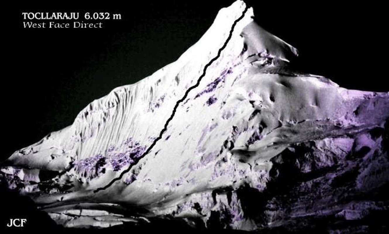
Route Description
Obvious line starting from the base of the west face. Depending on the season it might not be possible to attempt it; the later the season the worst. It is recomended a very early start to avoid a very soupy-snow ascent. From camp 1 (5.300m) traverse rightwards under the West Face and climb a line on the South end wich skirts the upper serac barrier on the right to join the south ridge 100m from the summit, 5-7 h from camp. And climb the snow mushroom.
Descent abseiling the snow mushroom summit and descent the NW ridge.
Essential Gear
The usual gear for a snow an ice climb. Crampons, ice axes, a few ice screws ( We never used them on the route because it got really soupy and dangerous), rope and snow-stakes.
 |
Red Tape
There are no proper fees to climb the mountain, although you will be asked for a little money the day you sign up in Collon in order to keep the trail to BC in good shape.
 |
Miscellaneous Info
It is a highly recomended route.
Although BC is not a cold camp, Camp1, 5.300 m. can get really cold on a windy day.
Best to climb in June-July, some seasons it can be climbed in August.
Suggestions
- Not far from Huaraz there are some sport climbing crags and boulders, look for: Recuay, Huanchac, Masuan, Monterrey y Laguna de Llanganuco.
- In Huaraz there are also some climbing stores that are not cheap.
- The notice board of Casa de Guias in Huaraz has a similar function to the one in Yosemite´s Camp 4. Also 'Casa de Guias' is the place to get information related to mountain and weather conditions.
- I suggest to use public transportation or 'Colectivos'.
- There is a very much trusted laundry service named 'B & B' located at 674, Av. José de la Mar.
- There are Internet facilities all over Huaraz.
- Best if you treat all water before you drink it.
 |  |
Books & Climbing Magazines
- “Escaladas en los Andes (Guía de la Cordillera Blanca)” by Juan José Tomé Ñacle, Ed. Desnivel 1999.
- “La Cordillera Blanca de los Andes” by Antonio Gómez Bohórquez and Juan José Tomé Ñacle, Ed. Desnivel April 1998.
- Juanjo Tome´s article about La Cordillera Blanca published in the climbing magazine: Desnivel #140, may 1998.
- Rock&Ice #71 & #88, there is information relating La Cordillera Blanca.
- “Climbs of the Cordillera Blanca of Peru” by David M. Sharman, Ed. Whizzo Climbs 1995.
- “The High Andes (A Guide for Climbers)” by John Biggar, Ed. Andes 1996.
- “Yuraq Janka” de John F. Ricker, Ed. ¿? 1977.
Information
All info gathered by:
Jonás Cruces
Mountain Guide & Rock + Ice Climbing Instructor
This is his website: www.todovertical.com
Andinista - Mar 21, 2005 11:28 pm - Hasn't voted
Route CommentFrom Ishinca base camp, walk to left side of the valley, and follow a sparkling stream. Eventually, cross to the right side of the stream and follow a faint path through the bushes. Head up the small valley between the large moraine ridge on your right and the left side of the main valley. Continue up this small valley for about half of its length, until, you can see cairns leading left, up the steep hillside. Follow this steep trail to the top of the slope, where the trail traverses 100m right, through a boulder field, toward the obvious snow ramp.
This snow ramp is at the bottom-right of a large rock buttress. Don crampons and walk up the snow ramp for about 200m, to the flat glacier ridge. There are many places to camp along this ridge (ca.5, 000m, 3-4 house from base camp). Beware of hidden crevasses.
Some people might consider making their high camp at 5,300m, instead of on the flat glacier ridge at 5,000m. Doing so would make the summit day shorter.
Andinista - Mar 21, 2005 11:32 pm - Hasn't voted
Route CommentThe west face of Tocllaraju offers the rare opportunity to climb a beautifully smooth, high-angle ice face for over 300m, followed by steep snow up the final ridge to a perfect summit. They don’t get much better.
Elevation gain: 1,032m from high camp; 432m from bottom of face.
Grade: D+.
Time: 2-3 hours from camp to bottom of face; 8-10 hours from bottom of face to summit.
Star your climb early. From camp, hike up the glacier as you would to reach the northwest ridge. About halfway to the ridge, leave the trail and head up to the right, toward the bottom of the highest end of the bergschrund. Cross where feasible, and gain acces to the face. Climb 55-degree snow and ice, right of the mixed ground in the middle of the face, for 6-7 pitches. Find a way through the serac barrier at the top of the face, which involves 150m of 80-degree ice. Ascend lower-angled snow slopes and reach the summit via the south ridge (8-10 hours from bottom of face).
Descent: Descend the north west ridge.
rgg - Jul 2, 2011 7:41 pm - Hasn't voted
Out of condition - permanent?On July 1, 2011, I climbed the NW ridge. Had the west face been in shape, we might have tried that, but it wasn´t, and I fear that it never will be again. High on the west face the ridge is corniced in various places, but that will surely change over time, and I expect there will almost always be places between the cornices to gain the ridge high up. More seriously, there are some big seracs threatening the route at the moment. And, most importantly, not too long ago, one of these must have come down and wiped the snow of a sizeable part of the west face, which makes it now a very dangerous mixed climb, with a large steep rocky section - still with seracs hanging over it. I would be very much surprised if the route would be climbable this year, and, given the recession of snow routes in general, the route might be gone forever. Perhaps a new route, a little bit more to the right of the direct west face route, is possible in due course, but currently, that variation too was seriously threatened by seracs. When I get a chance, I´ll post pictures showing the damage, but in the internet cafe´s here in Huaraz I cannot insert my sd-card, nor cd´s or dvd´s.
chrisc - Aug 13, 2019 4:35 pm - Hasn't voted
Summited 2019, in condition!I've been coming to the Ishinca Valley for the past 3 seasons to find this route seriously threatened by major seracs up high. As of 2019, the serac posing a significant risk to the face seems to have fallen off completely. (Must have been epic.). Climbed from shrund to the summit. Full trip report here!