
|
|
Mountain/Rock |
|---|---|
|
|
37.69700°N / 119.194°W |
|
|
12945 ft / 3946 m |
|
|
Overview
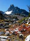
Banner Peak is arguably the most picturesque peak in the Sierra Nevada. It is the second highest peak in the Ritter Range, very close to its bigger neighbor Mount Ritter, 200 feet taller. Compared to Ritter, Banner Peak is much slimmer with a sharp profile; it is surrounded by 1500-2000 feet high vertical cliffs except on its southwest side. Banner Peak is most photogenic from the northeast: it seems to be floating on the vast 2-mile wide waters of Thousand Island Lake, while bulky Mount Ritter is hidden from view. However, photo ops from Shadow Lake make for an impressive panaramic view of both Ritter and Banner.
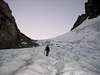
The easiest route to Banner Peak is class 2 from the Ritter-Banner saddle ascending its southwest slope. The saddle can be approached from Lake Catherine on the west side (class 2, but longer) or from Ediza Lake on the east side (class 3). The west side of the saddle is a steep snow chute at all times of the year. In early season (through July) it may be a simple manner of kicking steps when the snow is soft. Later in the season (Sept-Oct) it can be icy and a bit more imposing. If going by the Ritter-Banner Saddle from the east side, the route steepen to 3rd class as the snow gully narrows. Conditions vary in the late season (Sept-Oct) as in most cases the snow runnels out and makes for slushy conditions in the afternoon. Rock fall is always present and vigilance is required. Routes on Banner Peak's other faces and buttresses are much more challenging.
Although not as popular as Mount Ritter, Banner Peak is still frequently climbed. The surrounding wilderness area is one of the most popular backpacking destinations in California, comparable to Yosemite National Park. In fact, at one time this whole area was part of Yosemite, but was detached in 1905 due to conflicting issues over mineral rights in the area. Though many claims were made and many sites worked, no significant ore deposits have ever been recovered from the area.
 |
 |
 |
 |
 |
Getting There
Banner Peak shares the same access points with Mount Ritter. The closest trailhead is Agnew Meadows, elevation 8200 feet. From Agnew Meadows, take Shadow Lake Trail to Banner-Ritter's east side, or Thousand Island Lake Trail to Banner's north or west sides. To get to Agnew Meadows, take SR203 west from US395, passing the town of Mammoth Lakes, then the Mammoth Mountain ski area main lodge. Past Minaret Summit access is restricted in summer from 7:00a to 7:00p. See the Red Tape section for details.
An alternative approach is via Rush Creek Trail from the Silver Lake trailhead. This is a lower trailhead (7000 feet elevation) and involves a longer approach if you're ascending Banner's east side. Going for Banner's north and west sides the length of approach from Silver Lake is similar to Agnew Meadows. Besides, there are no access restrictions at this trailhead. To get to Silver Lake, take SR158 from US395 north of Mammoth Lakes.
 |
 |
Red Tape
Lots of Red Tape. SR203 west of the Minaret Summit(designated "Reds Meadow Valley") has travel restrictions due to the narrow one-lane road (in many sections) and the limited parking available at the popular national monument. Travel by car into the area is unrestricted before 7:00a and after 7:00p, so try to plan your trip accordingly. Between these hours it is required that you take the shuttle bus which leaves every 30 minutes, and more frequently during periods of high use (buses will accomodate backpacks). If you want to do a loop starting at Agnew and returning to Devils Postpile, you can ride the shuttle for free back to Agnew Meadows. Once your vehicle is in the area, you are free to exit anytime of day, but you will be subject to the $7 per-person charge if you haven't previously paid the fee and the entrance station is manned. (Handy Helps: Upon exiting, turn left just before the booth, heading toward Minaret Vista. Get a minutes worth of awe-inspiring views of the Minarets or turn right just up the lane (50 yards) and head out the entry lane (which is NOT a "one way" road). This avoids stopping at the booth altogether! The trick is not to get caught.....
But, if you have the dough to throw around, the entry fee into Reds Meadow Valley is $7 per person, which allows free use of the shuttle. National Parks Pass and USFS Adventure Passes are not valid here. The fee is used to pay for and encourage the use of the shuttle bus.
Overnite stays in the Ansel Adam Wilderness require free backcountry permits. These can be obtained from the Inyo National Forest website.
On the more popular trails (Thousand Island Lake, Shadow Lake, Minaret Lake, etc.) camp fires are not permitted and camping is restricted to designated areas. On popular summer weekends the quota for permits may run out, so advance reservation is advised (fee apply).
When To Climb
All year, depending on whether you want to climb on snow, ice, or bare rock. The Ritter Range peaks are composed principally of dark volcanic rocks, and are known to have much loose rock. For some, climbing on snow is preferred. During winter and spring the road beyond Minaret Summit is closed, so a longer approach is involved. The most popular climbing season is summer.
Camping
Back country camping in Ansel Adams Wilderness requires a permit. Camp fires are not allowed along most trails in this area, and camping location may be restricted (around Thousand Island Lake, Garnet Lake, Ediza Lake, etc.) See the Red Tape section. To protect your food from black bears, bear canisters are recommended.
Along SR203 there are many fee campgrounds, the closest ones are Agnew Meadows, Upper Soda Springs, Minaret Falls, Pumice Flat, Devil's Postpile, and Reds Meadow. Commercial lodging are available in the town of Mammoth Lakes and at the Mammoth Mountain Ski Area.
If you're approaching from Silver Lake trailhead, there are also many fee campgrounds along SR158, such as Silver Lake, Gull Lake, Reversed Creek, June Lake, etc. The village of June Lake has commercial lodging available.
Etymology
"Named in 1883 by Willard D. Johnson, topographer of the USGS, because he noticed cloud banners streaming from the summit."
- Erwin Gudde, California Place Names
External Links
- Earth Water Sky photo gallery
Beautiful photos of Banner, Ritter, Minarets, and surrounding peaks of Ansel Adams Wilderness. - Dale Stuart's John Muir Trail photos
Trips around Ritter Range documented by a woman moutaineer. - A dayhike - Sep 22, 2002
MarieP - Jul 2, 2008 11:29 am - Hasn't voted
Red TapeYou can drive in after 7:30 pm for $7 per person, and for free after 8:30 pm.
GlennD - Jun 3, 2013 2:22 am - Hasn't voted
Parks PassThey accept National Parks passes now for access to Agnew.
Allan Der - Aug 15, 2015 2:44 am - Hasn't voted
Re: Parks PassThey take my Interagency Senior Pass. I entered before 7AM via private car and the entrance station is closed, the did not check on my way out.