
-
 80248 Hits
-
 95.5% Score
-
 54 Votes
|
|
Mountain/Rock |
|---|---|
|
|
43.74920°N / 114.13°W |
|
|
12009 ft / 3660 m |
|
|
Overview
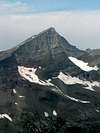
Hyndman Peak is a huge, pyramid shaped mountain. It sits at the head of Hyndman basin, which is surrounded by big, rugged, 11,000+ peaks. The easiest route to the summit is class 2, a moderate scrambe after a 6 mile approach hike. I would say that about 10 people summit the peak on the average summer weekend. Technical climbs of the peak are also available, and I've talked with quite a few people that have climbed the peak and boarded down in the winter. Hyndman Peak is the 9th highest peak in Idaho and a member of the Idaho 12ers, of which it is the easiest to climb (the rest are class 3). Still, it requires a 5,000-foot and 12-mile effort to ascend.
 |  |  |  |  |
Getting There
Drive five miles south from Ketchum on Idaho state highway 75 and turn (east) onto East Fork Road. Drive six miles east (1.5 miles past Triumph), then make a hard left turn up a hill at the sign which says "North Fork of Hyndman Creek". Drive another three miles to the first stream crossing where Johnstone Creek and other creeks come together. Cross Hyndman Creek, then continue on the dirt road to the north side of the creek for 1.25 miles until you come to a road closure sign and gate. Park here. From the trailhead, follow the trail along side Hyndman Creek to the base of Cobb Mountain. Here the trail turns north and leads up a sagebrush covered hill to a small pond next to point 8724. Follow the ridge on the left-hand side of the creek northeasterly up to Hyndman basin. From Hyndman basin, the trail is faint, but just head towards the saddle between Hyndman and Old Hyndman. Once at the saddle, follow the ridge to the top of Hyndman Peak.
 |  |
Red Tape
The Sawtooth National Recreation Area pass is history! There are no longer any fees to visit this area!!!
When To Climb
July - October are the best times to climb Hyndman. Climbing during the winter would add a around 7 miles roundtrip to the approach. There is also some avalanche danger in the winter, but the route can be done safely at times.
Camping
We camped right at the trailhead. Hyndman Basin, about 5 miles from the trailhead would be a great place to backpack into. There are trees and water in the basin.
Mountain Conditions
The Idaho Outdoors Forum is a good source of conditions information. This snotel site is on the lower route along Hyndman Creek and should give you an idea of snow levels. Here is the phone number for the Ketchum ranger district office: 208-727-5000
 |  |  |
Wildlife
We saw deer, elk, and got up close with mountain goats on our trip.
rleclair - Aug 2, 2005 11:18 am - Hasn't voted
Untitled CommentI believe with the recent changes to federal legislation regarding user fee areas, the requirement for a $7 daily pass to park at the trailhead no longer applies. There were no signs at the trailhead mentioning "Fee Area" or "Parking Pass Required." A call to the ranger district in Sun Valley/Ketchum may be in order to verify but that was my experience on July 31, 2005.
IdahoSummits - Aug 2, 2005 12:58 pm - Hasn't voted
Untitled CommentThanks for the heads-up guys. I have fixed the red tape section.
Arctic3 - Jul 8, 2009 9:16 am - Voted 8/10
Driving DirectionsThe driving directions seem a bit outdated and kind of confused me in getting there. The mileage was a bit off and there have been some changes since it was written. Here's my description edited from the original. At five miles south from Ketchum on Idaho state highway 75 turn east onto East Fork Road. Drive 4.5 miles east and you will come to an old mining town called Triumph. 1 mile past Triumph turn left turn on an unmarked well maintained dirt road. Drive another 4.5 miles to the trailhead at the North Fork of Hyndman Creek. There is parking and a toilet facility.
jbissen - Jul 27, 2010 11:39 am - Hasn't voted
Trail ClarityFollow the old road from the trail head is a bit vague and if you do that you go on the wrong trail. Pleas follow the sign showing trail 166.
technicolorNH - Aug 19, 2019 8:12 am - Hasn't voted
Accurate directionsOnce you get to East Fork Road (which has a large sign) set your odometer. At 5.9 miles (just past the tiny town of Triumph) the road will turn to dirt. At 7.1 miles turn hard left onto a fairly broad, unmarked dirt road. At 9.8 miles there is a minor stream crossing. At 11.9 miles you will come upon the TH, with toilet facilities to your left. The trail for Hyndman Peak is on your right, heading down hill to cross the stream. If you walk up hill on the other trail it will take you to Pioneer Cabin and Point 9669. The final part of the dirt road IS narrow with a steep drop off, but it and the stream crossing were doable in a low clearance Honda Civic as of the time of this writing.