
|
|
Mountain/Rock |
|---|---|
|
|
44.92350°N / 6.35710°E |
|
|
13455 ft / 4101 m |
|
|
Overview
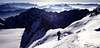
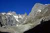
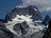
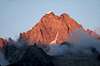
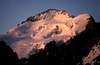
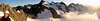
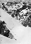
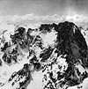
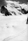
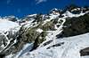
Geographical classification: Western Alps > High Dauphiné Alps > Barre des Ecrins The Barre des Ecrins is the most southly 4000m peak of the Alps. It's very easy to recognize the mountain when seen from the north. The whole region is a National Park including a lot of very famous peaks like La Meije or Le pelvoux. The barre des Ecrins is the highest peak of the region. The easiest route to the summit is a glacier tour with airial rockclimbing on the summitridge ( II ) The firn on the glacier can be till 50° on the final bar. The whole tour is PD . All the way is on the Glacier Blanc (white glacier) wich is 5 Km long. If you want an easy high climbing, go to the Dôme on the right of the noth face: you will go still over 4000 m. The south face is pure rockclimbing on a 1400 m high vertical face over the Glacier Noir (black glacier).
Danger !!! : Serac avalanche on normal route is at hi risk level now
Barre des Ecrins details on CampToCamp
 |
 |
 |
 |
 |
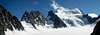
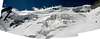
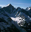
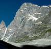
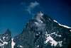
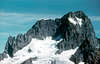
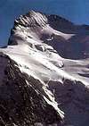
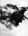
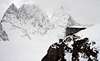
Barres des Ecrins south face
 |
 |
 |
 |
 |
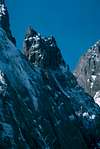
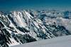
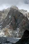
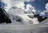
Barres des Ecrins south-west face
 |
 |
 |
 |
 |
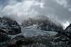
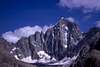
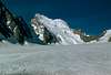
Barres des Ecrins west face
 |
 |
 |
 |
 |
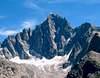
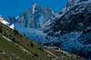
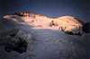
Barres des Ecrins north face
normal route to Dôme Barre Noire Couloir and east ridge route
 |
 |
 |
 |
 |
Getting There
Nearest Villages are: La Valouise (big) and Ailefroide (small and closer) for normal route (see link page) Saint Christophe en Oisans (big) and La bérarde (small and closer) for some other routes. starting point for the normal route : Refuge des Ecrins 3170 m. 4 hours to the summit from the hut.
 |
Red Tape
free to climb even if the peak is a National Park. You have to respect the rules of the parc. For example, NO DOGS IN THE PARK (see the http Link even the US version of the web site is not available yet) During the summermonths lots of people try the climb ! you may have to wait for the final part (the bar).
Climbing info
summer is the normal period (June-September) Meteo 9 days Briançon
Camping
camping and hotels in Ailefroide (Ailefroide means Cold Wing) Author: Mathias Zehring Date: Feb 09, 2002 07:29 AM I can highliy recommend the camping "Le Couroumba" in Les Vigneaux at the near La Vallouise : there is still sun while in the narrow valley in Ailefroide it's already cold. The 20 min you have to drive with your car do not realy matter. And you have a great view to the Mont Pelvoux no camping allowed in National Park
panorama
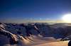
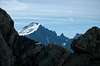
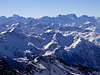
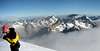
From the top you can see 130 peaks having 3300 m average height at a distance less than 24 km. In north direction you have Tarentaise Alps (3800m) , Mont-Blanc (4800m), Grand Paradiso (4000m) in Italy, Monte Rosa (4600m) between Italy and switzerland. In south east direction you can see the Viso (3841 m) in Italy near the french border.
 |
 |
 |
 |
 |
geology
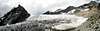
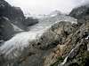
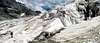
Barre des Ecrins glaciers
Glacier Blanc is on the north face of Barre des Ecrins. It has 5 km long. Glacier Noir north branch is under the SW face of Barre des Ecrins. It has 3 km long. Glacier de la Pilatte is short -1.5km - and separated in 3 Branches now. He's under the W face. Glacier de Bonne Pierre is 3 km long and is situated on the NW side of the Dôme.
 |
 |
 |
 |
 |
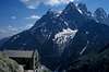
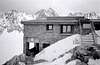
Ecrin's huts
Refuge du Glacier Blanc 2542 m CAF hut Situation: North/East side of Barre des Ecrins near Glacier Blanc open: 13 of April- 19 of May and 1st of june- 1st of September 13 avril au 19 mai, et du 1er juin au 1er septembre Capacity: 135 pers. Getting There: 2 hours 30 min from Pré de Madame Carle (670 meters up) Map: IGN Top 25 - 3436 Est Hut's phone : 04 92 23 50 24 Refuge des Ecrins 3175m CAF hut Situation: North side of Barre des Ecrins near Glacier Blanc Horizontal part. open: 13 of April- 19 of May and 1st of june- 1st of September 13 avril au 19 mai, et du 1er juin au 1er septembre Capacity: 120 pers. Getting There: 4 hours from Pré de Madame Carle (1301m meters up) Map: IGN Top 25 - 3436 Est Hut's phone : 04 92 23 46 66
 |
 |
 |
 |
historical routes
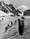
1st climbing was june25 1864 by Almer C. (Guide) Croz M. (Guide) Moore AW. Walker H. Whymper E. The route was from La bérarde (1738m), Bonne Pierre Glacier, Col des Ecrins (3415m), Glacier Blanc firn, east ridge (difficulties),return by west ridge and then Glacier Blanc to Vallouise. -------------------------------------------------------------------------------- 1st climbing direct in the middle of the north face: by R. Coolidge (500 steps tailed in the ice !). july 4 1870 -------------------------------------------------------------------------------- 1st South face climbing was september 3 of 1880 The route was from La bérarde (1738m), Glacier Du Vallon, Rocks of south-west face, south face, small glacier at the end, Barre des Ecrins (4102m)
 |
External Links
- Ecrins National Park Official Site you will find here a lot of information about the National Park
- La vallouise
- funny route to Dome des Ecrins
- Route to Barre des Ecrins (north face) Description of the normal route. (spanish)
- alpesexploration.com Page (in french) about Barre des Ecrins
- Oisans Massif site gives accomodations, meteo, photos and more and more...
- Barre des Ecrins at www.4000er.de Images, routes, coordinates and more information about the highest peaks of the Alps