
-
 29217 Hits
-
 93.58% Score
-
 43 Votes
|
|
Mountain/Rock |
|---|---|
|
|
46.61285°N / 8.41625°E |
|
|
Canton Uri, Gotthard |
|
|
Spring, Summer |
|
|
11765 ft / 3586 m |
|
|
Overview
Geographical classification: Alps - Western part > Uri Alps Group > Galenstock
Galenstock 3586 m
The Uri Alps Group (Urner Alps) are located in the Uri district, in central Switzerland, amongst three famous road mountain cols: Sustenpass to the North, Furkhapass to the South and Grimselpass to the West. The chain counts wonderful granite peaks and Galenstock 3586 m is one of those, dominating one of the most famous glaciers on the Alps, the Rhonegletscher, from which it originates the Rhône river.
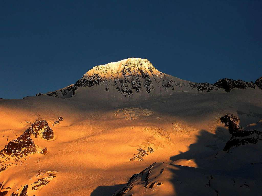
The peak shows different looks and has different action grounds depending on its sides. Towards West in the direction of the Rhonegletscher it's covered with snow and ice: it's the kingdom of ski-mountaineers. Towards Tiefengletscher it shows a steep rock and ice wall, while towards the Furkhapass it's eminently rocky. As a result, the climbing routes to summit Galenstock have extremely different characteristics. When you drive from the Wallis up the Rhone river to its source, there is one remarkable ice clad mountain in front of you, that will haunt you: it's Galenstock. If you drive from Italy over the Gotthard pass on the Furkhapass road, it shows a different looking overwhelming shape, but it is still the Galenstock.


It is the guardian of the Rhone glacier, that is the source of one of the main European rivers that flows into the Mediterranean sea near Marseille. The Rhone glacier is not as large as the Aletschgletscher, but it is more famous. Goethe was delighted by it, many artists painted it and looking at those old paintings we get a sad feeling, because unfortunately the alpine glaciers are going slowly to disappear. In 1850 this glacier reached the hamlet of Gletsch at 1770 m; today instead the tourists must drive up the Furka pass road to the hotel Belvedere at 2274 m of altitude in order to touch some real natural ice. The Seiler dynasty of Zermatt built first class hotels at the Belvedere and in Gletsch, which are still open to tourists and worth seeing, if you like to enhale the athmosphere of the 19th century. Early 1900 the railroad boom even reached Gletsch. Today the cogwheel railroad, called Furka-Oberalb Bahn (FOB), makes a short-cut in a tunnel, but some enthusiasts run the old steam engines on certain days as far as Gletsch and Furka (2160 m).


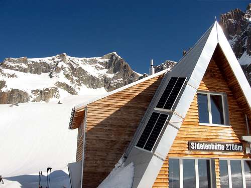
Before the boom of the automobile, the mountaineers needed that train in order to climb Galenstock. They took the train to the Tiefenbach station (1845 m) and walked to the Albert Heim hut (2542 m). The next day they climbed the Galenstock over its North ridge, using rope and crampons. Today, the Galenstock has different customers. They arrive by car at 5 o'clock in the morning at the Belvedere and climb the mountain with skis. Rock climbers often chose the small Sidelenhut near the Furka psss, that offers a dozen of possibilities in rock/ice or just in pure granite.
Getting there
The reference points to climb Galenstock are the Furkapass road and Belvedere Hotel. It's possible reach the Furkhapass both from Andermatt, a little town lying at the exit of St. Gotthard Tunnel, and from Wallis.
Main routes
North ridge (Normal route from Albert Heim Hut)
The starting point to climb this route may be the Furkha Pass road or, if you want to take it easier, the Albert Heim hut. From the shelter follow a good trail marked by cairns that leads north of Pt. 2713, then reach the Tiefenbach glacier, rather retired in its lower part. Rope up and head for the Tiefenstock. Stay as low as possible in the trough, because there is a minimum of crevasses. A steep slope leads to a plateau on the glacier near some seracs, that can be circumvented both right and left. You achieves thus the base of the rock wall and a crossing decisively towards the left takes you to the foot of the "Via ferrata", which allows you to overcome the rocky ramparts and reach the mountain Northern ridge.


On the ridge a magnificent panorama of the Rhone glacier and the Bernese Oberland will surprise you. From the saddle climb the steep but not difficult ridge to the top. PD- Crampons, rope, axe, no screws. 4 hours from the hut.
This route may be followed also by ski-mountaineers, who sometimes chose a straighter route to the base of the saddle and usually leave the skis there. It is possible to carry the skis to the summit and ski down to Belvedere.
North-South traverse A great course providing the complete crossing of Galenstock, which involves an easy climb (some moves grading II UIAA, fixed anchors) up the wall to get the North ridge as described above, with stretches of snow, while the descent follows the South ridge and the Rhône Glacier towards Belvedere. A good experience on glacier is needed. PD
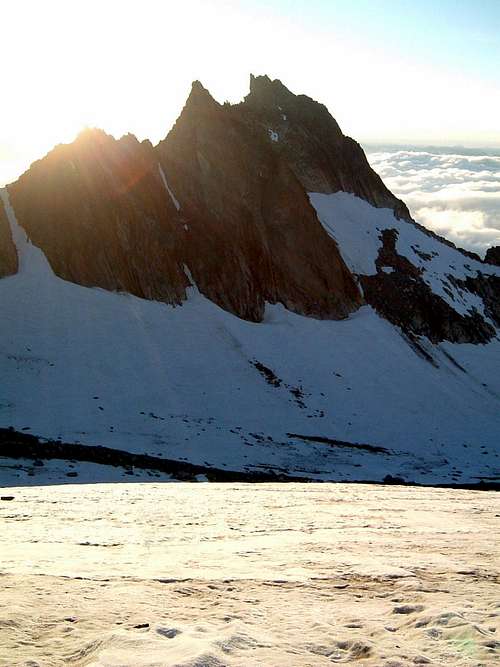
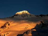
Sunrise on Tiefengletscher |
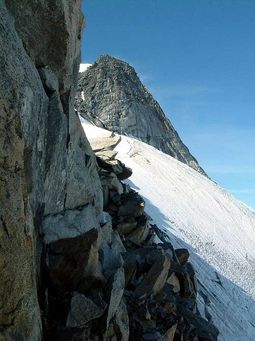
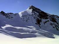
North Ridge - Ph. AlbertoRampini |
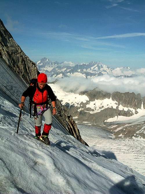
West side traverse on North ridge |
Normal Route from Belvedere (W side and S ridge)
From the Belvedere Hotel at about 2 Km West of the Furka Pass, on the Wallis side, take the Rhône Glacier to North, on the left orographical slope, up to approximately 2600 m, in view of a serach band. Turn Eastward to Galengletscher, heading to the obvious saddle named Galensattel 3113 m. Before reaching the steep slopes leading to the saddle, turn to left and do a a steep traverse leading to a wide hill. Follow it NE direction up to a rocky bend cut by a steep and narrow gully.


Depending on the conditions, climb it or the rocky band and then up steep slopes, keeping close to the South ridge. Climb the last meters along the South ridge (somewhat exposed) to get the summit.


Galengrat Verschneidung The Galengrat Südwand (Galengrat Verschneidung) is a 300 m, ten-pitch route on perfect granite. It combines slab climbing in the first pitches with a perfect dihedral in the last two pitches which directly leads up to the Galengrat. The route is bolt-equipped, anyhow some complementary gear might be useful.


The South-East Spur is often climbed in one day from the Furka pass road, which is a bit longer than the ascent from the Sidelen Hütte, after stay overnight at the shelter. From the hut traverse below the Hannibal Tower and reach the Sidelenglacier. Follow the glacier to the West side of the spur.


Just before reaching the base of the SE-face of the Galenstock, go NE to reach the start of the rock spur. The best start is probably left of the ridge, below the wide chimney which leads to a small notch on the spur (about 1-2 hours from the hut). The start of the spur is the least attractive, because of loose rock. Head slightly right to the notch on the spur. From the notch the climbing gets better and better. Reach the first rock step (III), bolts. After a short easier section you'll reach the second rock step (III+), again a lot of bolts. Continue along the ridge which gets less steep at the end. At the top of the spur (P 3365m on the map) you'll join the normal route coming from Hotel Belvedere. Climb the snow slope and the final snow crest to reach the summit (about 2-3 hours from the base of the spur to the summit).
Ski-routes
Normal route from Belvedere with skis
From Belvedere carry the skis up the hill above the parking place (15 minutes), then go left to the Rhone glacier and put your skis on. Follow the rather flat glacier for ca. 3 km. The first big crevasses welcome you, leave them at your left and stay in the steep trough that leads to the next flat part at ca. 2700 m. Now you can see the steep slope on your right hand side that leads to the Galensattel (3113 m).


It is possible that after a winter with little snow this part of the slope consists of pure, green ice. In such a case, I despise the Galenstock, stay on the Rhone glacier and go straight on to the easier, but higher Dammastock (3630 m). Usually this is not the case and you walk in the shadow up the the Galensattel, always on your skis. From the Galensattel it appears a fantastic view on this wonderful south ridge. The last slope is usually climbed on foot, since a mistake on the skis would send you in your fast and last run to the Rhone glacier. 5 hours, only for good skiers. Take rope, axe, crampons with you, which you will not need under normal conditions.
Views of Galenstock
 |
 |
 |
 |
Red Tape

No fees or permits needed to climb or hike. Anyhow be aware that:
- Free camping is not allowed in Tatsch
- A toll is needed at the start of the road to Tatsch
Accommodation
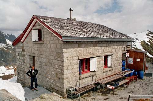
Albert Heim Hut
To the East (Gotthard) side of the Furka pass you can stay at the Hotel Tiefenbach (2109 m) on the Furka pass road, good food, simple and clean rooms, reasonably priced. To be reached by car or bus. Phone: ++41 (0)41 887 13 22. Mobile: ++41 (0)79 208 80 55.
Sidelen Hut
Huts
Albert Heim Hut 2541 m
Owner: SAC (Swiss Alpine Club) Sektion UTO
Size: 80 places
Approach: in 2 hours from Tiefenbach or 1 hour from the Tatsch parking.
Albert Heim on Summitpost: Albert Heim Hut
For rock climbers (granite) in summer the small Sidelenhut 2708 m is located 1 hour above the Furka pass road, between Kleine Bielenhorn and Sidelenhorn.
When To Climb
Mountaineering: Best season goes from the end of June to middle September
Ski: May and June
Meteo
Guidebooks and Maps
Clubführer Urner Alpen West edited by the Swiss Alpine Club
Link for books and maps: Literature and Maps
Canton Uri Official Maps:
CNS - Urseren 1231 1:25.000
CNS - Sustenpass 255 1:50.000