
-
 190152 Hits
-
 99.96% Score
-
 182 Votes
|
|
Area/Range |
|---|---|
|
|
45.83120°N / 6.86770°E |
|
|
Hiking, Mountaineering, Trad Climbing, Ice Climbing, Aid Climbing, Big Wall, Mixed, Skiing |
|
|
Spring, Summer |
|
|
15784 ft / 4811 m |
|
|
...
 |
in honor of Rahel Maria Liu the former maintainer of this page, dead while attempting to climb the Innominata Spur on the southern face of Mont Blanc. |  |
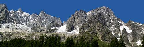
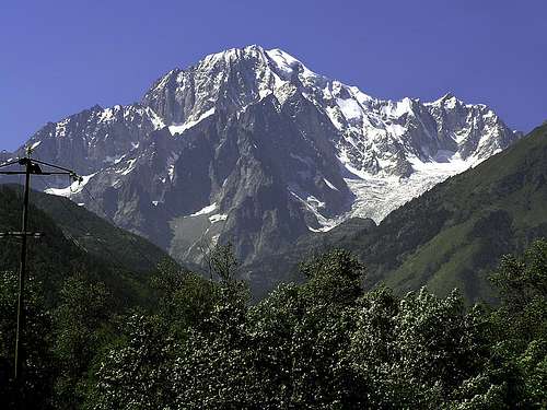 His Majesty the Mont Blanc His Majesty the Mont Blanc |
First of all an useful and very important info ....
The Mont Blanc Massif is the western big pillar of the Alps.
Therefore, the western stream which is dominant in Europe meets its first big obstacle here.
The results are often very strong storms and very fast and drastic changes of the weather.
I can remember some peaceful walks on the Mer de Glace or on the Glacier du Geant, coming back from routes, with no wind, no cold at all...
But I can remember also some difficult and dangerous escapes with strong wind, very cold temperature, no visibility ... in summer.
NO climbing action over 3000 m should be undertaken if you are not absolutely sure about weather conditions, rescue operations sometimes are almost impossible, you must think you don't have to relay on it
None can understand what is bad weather if he hasn't experienced it here, bad weather here is a killer !
Overview
The Mont Blanc Massif is the emblem of the Alps, even of the European mountains altogether.
About the Mont Blanc Massif a lot has been written, by different people with different interests. I would like to allow a mountaineer to speak now who maybe has known the whole Mont Blanc Massif better than any other person in the world during his time: the former French guide from Chamonix Gaston Rébuffat. He was born in Marseilles in 1921 and became a Chamonix Guide in 1946. Thereafter he made a string of new routes and important repeats, notably of the great alpine North Faces. He was a member of the successful Annapurna expedition in 1950 playing a major role in the saga played out in the final stages of that historic ascent. He died in 1985. In 1974, he wrote:
"What an extraordinary creation this is, wrought by earth and time!
Magnificent seen from a distance, for climbers it is a real paradise. Nowhere else has the earth been so generous to them.
There is an abundance of peaks, mountains and aiguilles, each one prodigal of ridges, pillars, buttresses, faces.
And yet, in terms of area, the range is relatively small. If you look at it on a map of the Alps, it is only a small corner of that great range of mountains curving over several hundred kilometres, from the Mediterranean to Austria.
The range is only 30 kilometres long and 12-15 kilometres broad; the Mont Blanc tunnel is only 11,6 kilometres long.
Such an abundance in so small a compass could well have produced a feeling of clutter or chaos, but not here.
On the contrary, here we have a sense of quite exceptional harmony: every peak in its place, linked to every other and yet separate, with its own separate identity and history, its own appeal, and all of them linked to the greatest, to that Mont Blanc which has lent its name to the range as a whole.
The French side of the range is awe-inspiring. It takes the form of massive yet shapely glaciers from which there emerge extraordinary aiguilles, soaring into the sky in a series of shoulders and soaring faces.
At any time of the day or the year these glaciers are places of mystery, with a strange fascination.
It is very understandable that once - and not so very long ago - they were a source only of fear or even terror, and that they were thought of only as errors of nature, a waste of the earth's energy.
Even today, when routes cross them in all directions, they still inspire us with awe, wonder or amazement.
The western end of the ridge, the Mont Blanc end, is composed principally of glaciers, whereas the eastern end has, silhouetted against the snow and the sky, those granite aiguilles whose soaring lines and glowing rock make them seem overflowing with new vitality. Ice and rock together are a unity, the one bringing out the beauty of the other; though each alone would have undeniable beauty, it would lose much of its character."
(Gaston Rébuffat: The Mont Blanc Massif. The 100 Finest Routes. London 1996. P. 9)
Most not european people when speaking about Mont Blanc immediately think to Chamonix forgetting or not knowing that the most mighty and difficult walls are on the south side, bordered by Val Veni (west) and Val Ferret (east) that join together few km above Courmayeur (Valle d'Aosta - Italy)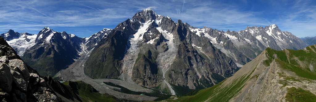
Geographical overview
The Mont Blanc Massif is surrounded by some big valleys: The valley of the Arve in the Northwest, the Val Montjoie in the West, the Val Veni and the italian Val Ferret in the South and Southeast, and the swiss Val Ferret in the East.
The Mont Blanc Massif is the most superb area of the Alps, not only because of its highest summit, but also especially because of its wilderness, the big rock- and ice-faces which fall down steeply. The mountains of the Mont Blanc Massif are more varied than the other groups of the Alps. The Arve valley, the Val Vény and the Val Ferret build a natural demarcation in the West and East. The Val d'Etremont is the continuation of the eastern border and the northern border as well. It separates the Mont Blanc Massif and the Walliser Alps. Less natural and distinctive is the southern border. It is the southwestern continuation of the Val Vény over the Col de la Seigne. It follows the uppermost Val des Glaciers till Les Glaciers, or rather Les Chapieux, and goes over the Col du Bonhomme to Les Contamines before it meets the Arvevalley at St. Gervais.
The Mont Blanc shows totally different shapes to the North and to the South: to the Arvevalley, it has huge and beautiful white glaciers and very long firn hangs in the summit region. To the Val Vény and Val Ferret, it shows wild and dirty glaciers which are situated among sharp rock ridges which fall down to the valleys and have very steep faces with rock- and ice-couloirs as flanks.
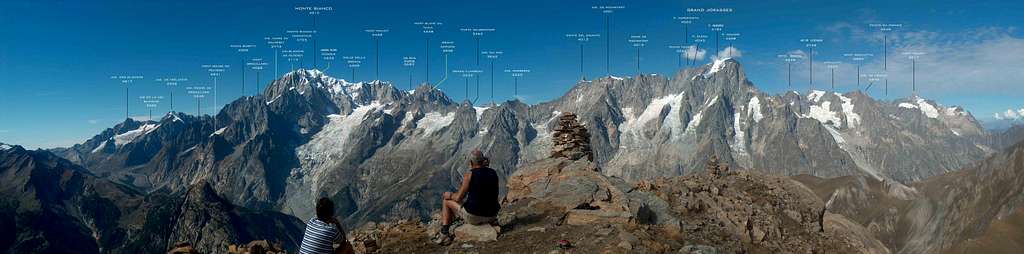
At the beginning of Alpinism history Mont Blanc Group was considered as composed by 4 different summits : Aiguilles du Trelatete, Mont Blanc, Grandes Jorasses, Mont Dolent..
Now we can consider it a little better and divide the whole group in 2 big areas (the division between the two area is made by the Geant glacier and by the Mer de Glace) and many big ridges bordered by glacier basins
Western area - Mont Blanc Massif
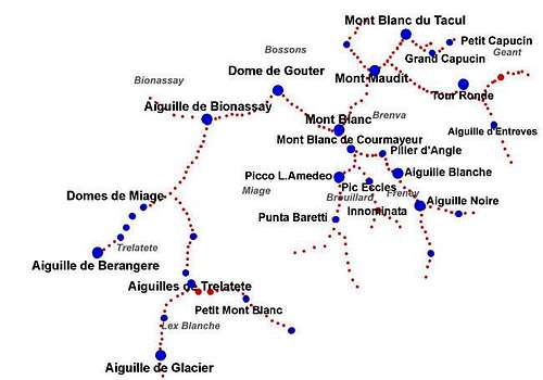 |
Main subgroups-ridges Glaciers-Trèlatète, Miage-Gouter, Mont Blanc, Brouillard-Innominata, Peuterey, Maudit-Tour Ronde, Tacul, Midì-Plan - Aiguilles de Chamonix |
The western part is almost a unique massif : the Mont Blanc, wherefrom, toward all the directions, start some very big and high ridges without any "easy" passage.
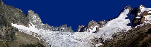
Glaciers
Some very big glaciers come down along main summit sides :
- toward North the 2 big ones : Bossons and Taconnaz
- toward West the ones of Dome and Monte Bianco, joining in the bigger glacier of Grand glacier de Miage
- toward South the 2 "small" Brouillard and Frêney
- toward East the Brenva
From the big ridge Gouter-Bionassay-Domes de Miage - On the French side (toward East) they are (N-S) :
Griaz - Bourgeat (small), Bionnassay, Petit Miage, Covagnet, Armancette (small), Tré-la-Tête, Glaciers - On the Italian side the Glacier di Bionassay (ending in the Miage) and the Lex Blanche (on the S side of the Aiguilles de Trelatete)
From the big ridge Midi-Aiguilles, they are (W-E) : - toward East : the Vallee Blanche (ending into the Mer de Glace), (Géant - Mer de Glace)
- toward North : Pélerins, Blaitière, Nantillons
we haven't to consider as glaciers the icy walls of Maudit and Tacul
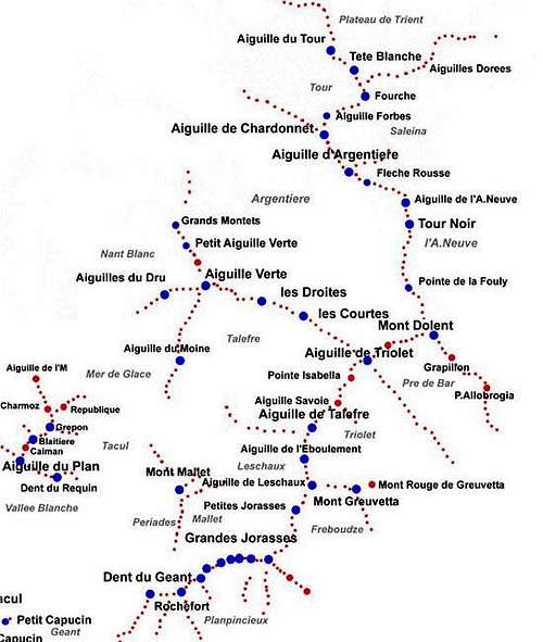
Eastern area - Jorasses-Verte chain
![eastern section of Mont Blanc...]()
Main subgroups-ridges
Gèant-Rochefort,
Jorasses,
Leschaux-Talèfre,
Triolet-Dolent,
Verte,
Tour Noir-Argentiere,
Chardonnet-Tour![]()
The Eastern part is little more complicated ..
Glaciers
From the big, long and almost unceasing ridge Geant-Dolent a sequence of glaciers, some small and some important come down - toward South (W-E):
Entrèves and Toula (small), Rochefort (small), Planpincieux-Grandes Jorasses (small), Tronchey - Pra Sec (small), Frébouze, Triolet, Pré de Bar - toward North (W-E) :
Periades (small), Mont Mallet-Leschaux - ending into the Mer de Glace, Taléfre - ending into the Mer de Glace being the southern border of the ridge Verte-Dolent
From the big ridge Aiguille Verte-Dolent - toward West some small glaciers : Charpoua, Dru, Nant Blanc, Montets, Pendant
- toward North only big ice walls but, at the western limit, just beneath the Aiguille Verte, the Glacier des Rognons that ends in the big one of Argentière
From the big ridge Chardonnet-Dolent - toward South (ending into the Argentiére) (from W to E): Chardonnet, Milieu, Amèthystes, Tour Noir and the (minor) Dolent
- toward North the Tour
- toward East the glaciers of Saleina, de l'A Neuve and of Dolent
From the ridge de l'Aiguille du Tour, toward N the Glacier des Grands, the big glacier named Plateau du Trient and the smaller Orny
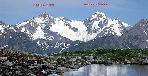
Glaciers-Trèlatète
Main summits :![Aiguille de Glaciers e...]()
This ridge, oriented S - N starts from Col de la Seigne (2514m - the end of Val Veny), ends with Col Infranchissable (3347m) and is limited by Glacier de Trelatete (west - France) and by the Ghiacciaio del Miage (east - Italy)
Routes are normally very long and require a lot of hours but have classic high mountain difficulties so that this can be considered a good range for acclimatization and training.
Aiguilles des Glaciers 3818m
Aiguille de le Lex Blanche 3697m
Aiguilles de Trelatete 3920m
Tète Carrèe 3726m
- from Aiguilles del Glaciers a ridge toward west ends with the Mont Tondu 3191m
- from Aiguilles de Trelatete a ridge toward SE contains the Petit Mont Blanc 3427m and ends with the Aiguille de Combal 2839m
Just near the Rif. Elisabetta a twin summit : les Pyramides Calcaires (a limestone mountain in the granite kingdom !)
Accomodations :
Bivacco Giovane Montagna near the Petit Mont Blanc
Rifugio Elisabetta Soldini 2200m
Hotellerie de Trélatéte 1876m
Refuge Robert Blanc 2750m
Glaciers-Trèlatète photo album
Miage-Gouter
Summits (from W to E) :![Dômes de Miage]()
This is a ridge oriented SW-NE, north of the previous section, almost always covered by glaciers, made of normally easy mountains ...
The favourite range for all those ones that need wonderful views with classic difficulties and with low risks.
Aiguille de la Bérangère 3425m
Domes de Miage 3668m
Aiguille de Bionassay 4051m
Aiguille du Gouter 3863m
Dome de Gouter 4308m
Accomodations :
Refuge de Plan Glacier 2680 m
Refuge des Conscrits 2580 m
Refuge Durier at the Col de Miage 3367m
Tête Rousse Hut 3167 m
Refuge du Goûter (Goûter Hut) 3817 m
Miage-Gouter ridge photo album
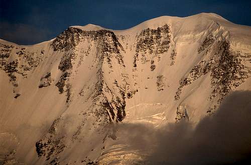
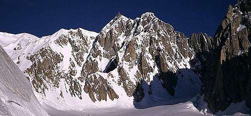
Mont Blanc
![Le Mont Blanc (4810m),]()
With 3 distinguished elevations (Mont Blanc 4807-4810m, La Tourette 4747m and Monte Bianco di Courmayeur 4769m) this is the main summit of the group and Europe, huge, various, easy and extreme ... a must for all climbers ! what else ?
Normal route is a walk, with fine weather, a death trap with bad weather :
if you hear somebody saying easy hike, without problems you can be sure he is a lucky beginner ...,
(M.Blanc needs to be respected)
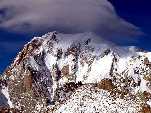
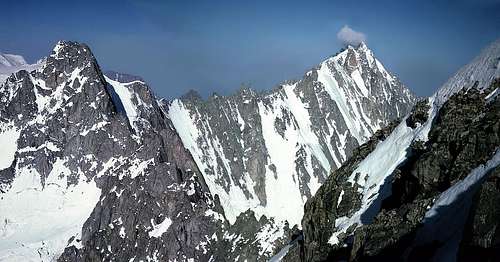
4 sides very different from each other ..
![North side of Mont Blanc group]() North side : enterely covered by ice and snow
North side : enterely covered by ice and snow![Brenva wall from near the Col...]() East side (Brenva) : a hugewall mixed ice and rock
East side (Brenva) : a hugewall mixed ice and rock![Mont Blanc de Courmayeur - S side]() South wall: the wildestand the most difficult
South wall: the wildestand the most difficult![the western side from...]() West wall: like the Brenva,a little safer but forgotten
West wall: like the Brenva,a little safer but forgotten
and the 4 sides are divided by 4 fantastic ridges
give a look to its page
Accomodations :
Refuge des Grands Mulets 3051 m
Vallot Hut (emergencies only) 4362 m
Rifugio Gonella 3071 m
Rifugio Quintino Sella 3363 m
Refuge des Cosmiques 3613 m
Bivacco della Fourche![]() -
- ![]()
these pics show the door to the Brenva side coming from Mer de Glace-Glacier du Geant
Brenva side photo album
West side photo album
North side photo album
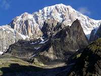
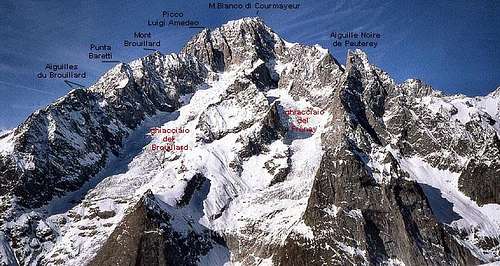
Brouillard-Innominata
On this ridge some very interesting, but almost unknown summits :![Brouillard and Frêney...]()
Starting from the Monte Bianco di Courmayeur summit (the south summit of Mont Blanc) a long ridge goes toward south.
Delimited on west side by the M.Bianco glacier and on east side by the Brouillard glacier,.
All activities in this range (except the Aiguilles du Brouillard) require high skill and training.
Picco Amedeo 4470m
Mont Brouillard 4050m
Punta Baretti 4006m
Aiguilles du Brouillard 3364m
On the higher part of this ridge another smaller ridge comes down toward SSE : the Innominata ridge that divides the 2 wildest areas of Mont Blanc : the Brouillard and the Freney
On this ridge some minor summits :
Pic Eccles 4038m
Punta Innominata 3732m
Aiguille Croux 3257m
Accomodations :
Rifugio Monzino (Rifugio Gamba) 2561 m
Bivacco Lampugnani 4000m
![]()
![]()
![]()
![]()
South side photo album
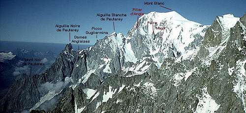
Peuterey
On this ridge some very important summits :![the Peuterey ridge from...]()
The finest ridge of the whole group !!!
One of the wildest and dangerous area of M.Blanc group.
Coming back or escaping is never easy !
It divides the S side of Mont Blanc (Freney glacier) from the more famous East side : the Brenva
Aiguille Blanche 4108m
Picco Gugliermina 3893m
Les Dames Anglaises 3592m
Aiguille Noire 3773m
Mont Noir 2928m
Mont Rouge 2941m
Accomodations
Rifugio Monzino (Rifugio Gamba) 2561 m
Bivacco Borelli Lorenzo 2325 m
Bivacco Eccles (Bivacco Lampugnani) 3860 m
Bivacco della Fourche
Bivacco Craveri alle Dames Anglaises
Big Peuterey ridge photo album
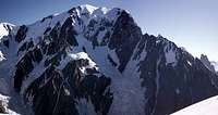
Maudit-Tour Ronde
Main summits :![Circle Maudit - from Tour...]()
Divided from Mont Blanc central hub by the Col de la Brenva
This ridge is the NE limit of Brenva glacier.
All the routes on the walls, ridges and channel toward Brenva and Cirque Maudit require skill, training and good weather.
Mont Maudit 4468m
la Fourche 3741m
Calotte de la Brenva 3703m
Tour Ronde 3798m
Pic de la Brenva 3504m
Aiguille de la Brenva 3281m
Aiguille d/Entréves 3604m
Aiguille de Toula 3538m
Grand Flambeau 3566m
out of the North-West face of the Mont Maudit a very interesting rocky pinnacle
Pointe Durier 3997m
Accomodations :
Rifugio Torino 3371m
Refuge des Cosmiques 3613m
Ridge Maudit - Tour Ronde photo album
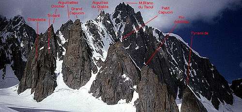
Tacul
From the main summit![Mont Blanc du Tacul and its...]()
A real "paradise" for rock climbers !!
Between the Col Maudit and the Col du Midi
Here one can "steal" some routes even if the weather is not good (never try the Gervasutti or Boccalatte pillars or Gervasutti couloir with bad weather)
Mont Blanc du Tacul 4249m![]() -
- ![]()
2 ridges come down
to the south the Diable ridge, full of pinnacles, one of the best area for rock climbers of the whole group:
Aiguilles du Diable 4114m
la Pyramide 3468m
Grand Capucin 3838m
Petit Capucin 3693m
Pic Adolphe 3535m
le Clocher 3853m
la Chandelle 3561m
le Trident 3693m
to the East side the Rognon ridge on which 2 summits are important for climbers :
Pointe Lachenal 3622m
Pilier Est du contrefort NE 3900m
Accomodations :
Rifugio Torino 3371m - a suggestion ... I slept only one night in rifugio Torino (the first and last : too expensive and low comfortable)
After that I used to start directly with the first (6:30 o clock) cable car (for satellites du Tacul) or with the last cable car, starting immediatly, to get the Fourche or the starting point of the routes ... few hours to wait the sunrise and go !
Refuge des Cosmiques 3613 m
Mont Blanc du Tacul and its Satellites photo album
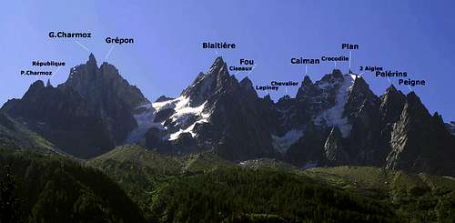
Midì-Plan - Aiguilles de Chamonix
![Aiguille du Plan and Chamonix...]()
This is a very complex structure ....
A little underestimate for risks ...
Some Aiguilles can be climbed even if the weather is not fine (Moine, Peigne ...) but many are real high mountain summits with high mountain routes.![Aiguilles de Chamonix - labeled]()
Aiguille du Midi 3843m
a linear ridge goes north-east till the
Aiguille du Plan 3673m
which is the first hub of a series of ridges full with important pinnacles
the SE ridge has 2 summits, Pain du Sucre (envers du Plan) and Dent du Requin
the NW ridge goes down with the Aiguille des Pelerins and Aiguille du Peigne
the NE ridge has 3 fine summits, Dent du Crocodile, le Caiman and the Aiguille du Fou, then goes to the Aiguille de Blaitiere
and to the second hub :
Aiguille du Grepon where from 2 further ridges start :
the N ridge that, passing through the Aiguille du Charmoz and the Petites Charmoz ends with the Aiguille de l'M
the NE ridge coming down to the Aiguille de la Republique and to the Tete de Trelaporte till the Mer de Glace
Accomodations :
Refuge Plan de l'Aiguille 2207 m
Refuge des Cosmiques 3613 m
Refuge Envers du Plan 2520m
Refuge du Requin 2516m
Aiguilles de Chamonix photo album
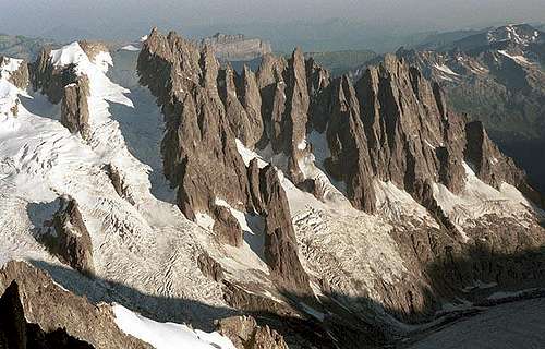
Gèant-Rochefort
First ridge east of the Col du Gèant is the Marbrèe-Jetoula ridge , coming out from glacier du Gèant, this ridge goes southward with some minor summits:![the range Mont...]()
This section is very famous but not so much known, starts from Col du Gèant and ends to the Col des Grandes Jorasses.
Never underestimate this area, even Dent du Geant can give problems due to bad weather, crowd or too hot sun.
Aiguilles Marbrèes, Tour de Jetoula and the Dent de Jetoula with its very fine South ridge (800m - D)
After this minor ridge, from the Col de Rochefort, the main ridge grows toward N till the Dent du Geant 4013m, the most famous summit.
North of this summit the long ridge of Clochers de la Noire divides the Glacier du Geant from the Glacier des Periades.
East of Dent the famous Rochefort ridge with its summits :
Aiguille de Rochefort 4001m
Dome de Rochefort 4016m
Calotte de Rochefort 3976m
North of the Aiguille an important ridge, toward north, divides the Glacier des Periades from Glacier du Mont Mallet
On this ridge, from S to N, some interesting (but almost forgotten) summits :
Mont Mallet 3988m
Les Periades a long series of strange, amusing pinnacles
Aiguille du Tacul 3438m
<b ecc.
South of the Aiguille another important ridge with two known and sometimes climbed (rock is very fine) summits : the Mont de Rocherfort 3456m and the Aiguille Rouge 3109m
Accomodations ;
Rifugio Torino 3371m
Bivouac Chevalier3460m at the Periades
Geant-Rochefort-Mallet photo album
Jorasses
![Rochefort - Jorasses]()
The hugest rock structure of the area and, maybe, of the whole Alps
A real high mountain environment, looking like the S side of M.Blanc and with huge and himalaian routes on all sides
Starting with
the Punta Young only 3996m high, the ridge goes on with
the Punta Margherita 4066m,
the Punta Elena 4045m,
the Punta Croz 4110m,
the Punta Whymper 4184m,
the Punta Walker 4208m
and, at last comes down to the Col des Hirondelles (3484m) ....
these are the Grandes Jorasses
each climb or hike in this area will never been forgotten !
Accomodations :
Boccalatte-Piolti Hut (2803 m.)
Ettore Canzio bivouac (3825m.)
Giusto Gervasutti bivouac (2833 m.)
Mario Jachia bivouac(3250m.)
Leschaux hut (2450m.)
further info in Grandes Jorasses page
![]()
![]()
![]()
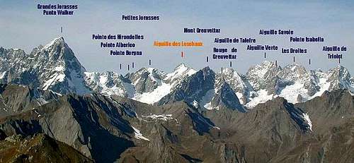
Leschaux-Talèfre
North of the Col, the ridge has a first minor summit, the Pointe des Hirondelles 3520m with its big West wall then, crossing 3 minor summits (Punte Alberico, Antoldi, Borgna) goes on to the![The range from Grandes...]()
starting from Col des Hirondelles (west border) the ridge gets less and less famous and unfrequented even if alpinistic goals in this area are very important ...
les Petites Jorasses 3658m with its fantastic West wall and to the
Aiguille de Leschaux 3759m, a hub from which two ridges start :
to the East the Greuvetta group 3684m
to the North the main ridge goes on with the
Aiguille de l'Eboulement 3609m
Aiguille de Talefre 3730m,
Aiguille Savoie 3604m
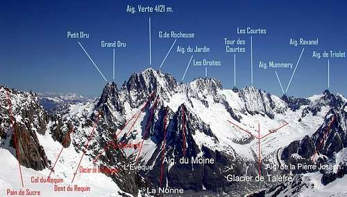
From Aiguille de Talefre, toward West, a ridge comes down dividing the Glacier de Leschaux from Glacier de Talefre, on this ridge some minor summits: the most know is the Aiguille de Pierre Joseph 3361m
Accomodations :
Bivacco di Freboudze 2360m
Giusto Gervasutti bivouac 2833 m
Gianni Comino Bivouac 2430 m
Rifugio Dalmazzi2590m
Refuge du Couvercle 2698m
Refuge de Leschaux 2431m
![]()
![]()
Triolet-Dolent
After the Col de Talefre the main ridge, passing through the minor summits of Pointes du Papillons and Punta Isabella, goes on to a very important summit :![Triolet-Dolent]()
Aiguille de Triolet 3874m
this is a hub, the starting point for:
toward SE the fine minor ridge of Monts Rouges de Triolet
toward NW the big chain leading to the Aiguille Verte
![Triolet - Verte]()
after two minor summits : the Pointe du Domino and the pointe du Pre de Bar the ridge ends with the
Mont Dolent 3821m
from this important hub, toward South the ridge, through the Mont Grapillon and some minor summits goes down to tthe Col de Grapillon and Col de Grand Ferret, eastern border of the massif.
Accomodations :
Bivacco Fiorio
Cabane de l'A.Neuve 2761m
Refuge d'Argentiere 2771m
![]()
![]()
![]()
![]()
![]()
Verte
Starting from Aiguille de Triolet the ridge, going toward WNW has first a small serier of rock pinnacles :![Il gruppo dell aiguille Verte...]()
This is the big ice walls section of the whole group, a long wide wall where 3 special summits rise directly (North side) from the Glacier des Rognons (the upper south side of Glacier d'Argentiere)
But is also the section that contains the most difficult summit of the whole group ....
Aiguille Mummery 3700m,
Aiguille Ravanel 3696m,
Aiguille qui Remue whose name keeps climbers away ..,
Aiguille Croulante whose name keeps climbers away .. ,
and, at last, the 3 fantastic summits :
les Courtes 3856m
les Droites 4000m
Aiguille Verte 4121m
between the last two ones the Aiguille du Jardin that should not be considered as a separate summit.![]() -
- ![]()
From the Aiguille Verte three ridges :
the North ridge, first summit is the Aiguille Carree, then follows the Petite Aiguille Verte and ends with the Aiguille des Grands Montets
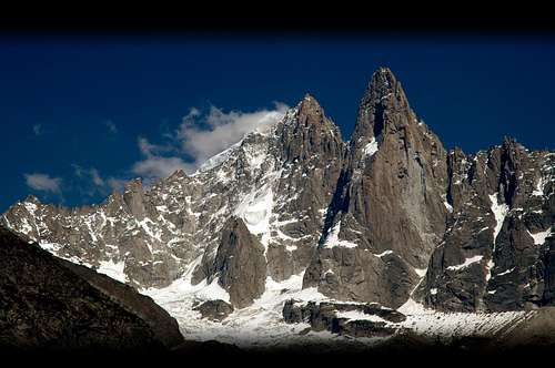
the West ridge is the most important for climbers, ending with the Aiguilles du Dru 3754m, a name that is a myth![]()
the South ridge comes down with some amusing and nice summits, from N to S :
le Cardinal, l'Eveque, la Nonne and the Aiguille du Moine
between these 2 ridges a very fine cirque containing the small Glacier de la Charpoua![]() -
- ![]() -
- ![]()
Accomodations :
Refuge du Couvercle 2698m
Refuge Charlet 2841m
Aiguille des Grandes Montets3297m (cablecar)
Refuge d'Argentiere 2771m
Cabane de Saleina2693m
![]()
![]()
![]()
![]()
![]()
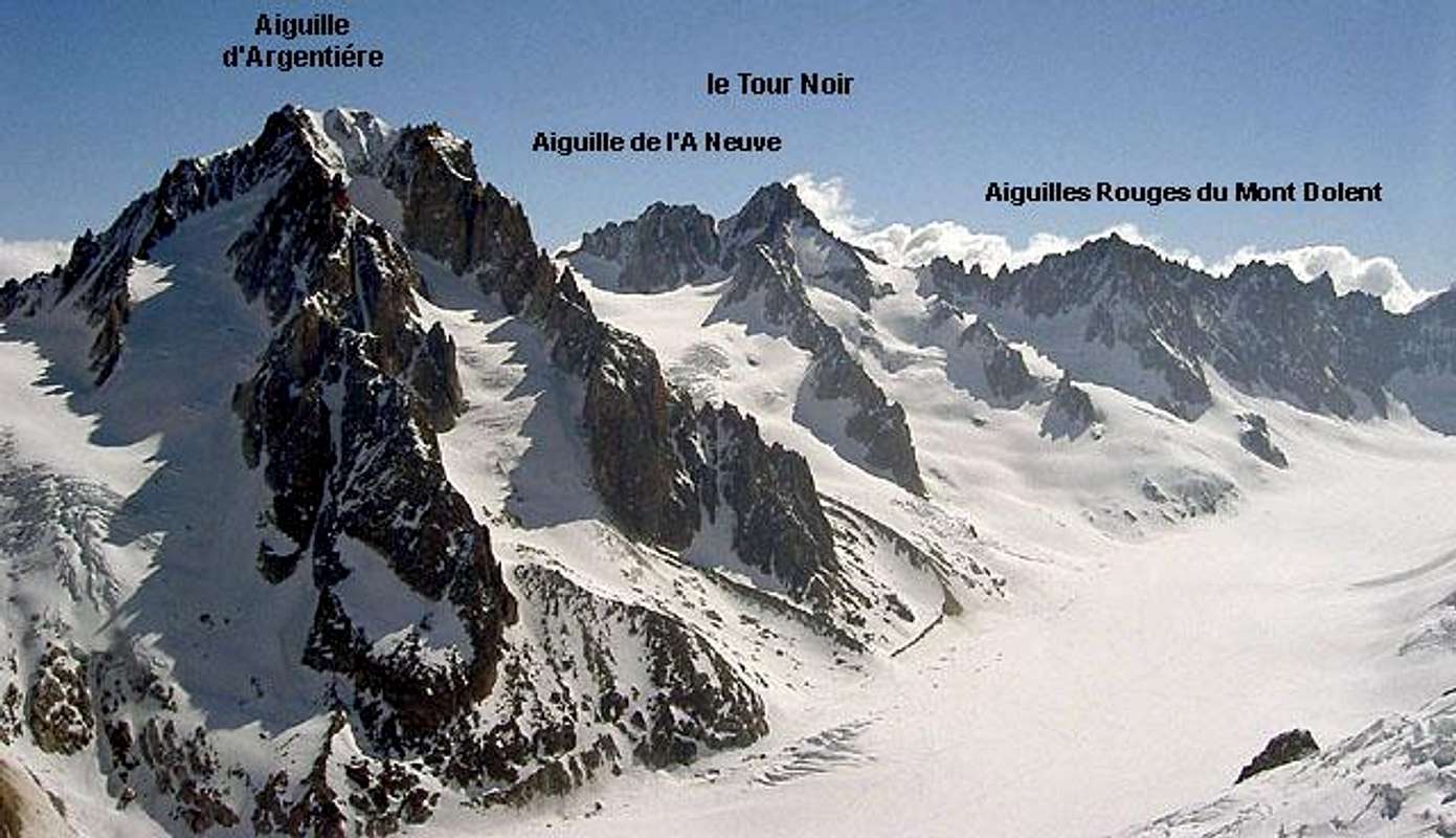
Tour Noir-Argentiere
Starting from Mont Dolent, the main ridge goes straight toward North.![]()
After the Breche de l'Amone, a series of minor summits make the
Aiguilles Rouges du Mont Dolent (l'Aiguille de l'Amone, la Pointe de la Fouly, the Grand Gendarme, the Pointe Kurz and some minors)
then grows again with the
le Tour Noir 3836m and l'Aiguille de l'A,.Neuve 3763m
After this summit the ridge goes toward WNW and, passing through the Fleche Rousse goes to the
Aiguille d'Argentiere 3902m
followed by the Col d'Argentiere (3323m) that is the best passage between the Glacier d'Argentiere (France) and the Glacier de Saleina (Switzerland), along the Glacier du Chardonnet.
This is the easier (?) area for ski-mountaneering.
Accomodations :
Refuge d'Argentiere 2771m
Cabane de Saleina2693m
![]()
![]()
Chardonnet-Tour
After the Col du Chardonnet the ridge rises to the
Aiguille du Chardonnet 3862m
the ridge turns toward NE dividing the Glacier du Tour from Glacier de Saleina till the Fourches (Grand-3611m and Petit- 3512m).
Starting from here mountains begin to lose the typical majesty of the group, the rock changes from granite to gneiss and become "tamer"
From this hub 2 ridges go down to end the Mont Blanc massif ...
The North ridge contains some fine summits :
Tete Blanche 3429m, Aiguille du Col de Tour, Aiguille Purtscheller and, the most famous
Aiguilles du Tour 3542m,
followed by the Aiguille du Pissoir (don't ask me the meaning )
)
and ends without story .....
The East ridge comes down with some famous small summits:
the Aiguilles Dorees
goes on with the Portalet
... some minor summits (in this section you can find the Ecandies), surround the Glacier d'Orny before the end of the ridge
Accomodations :
Refuge Albert I 2706m
Cabane de Saleina2693m
Cabane du Trient 3150m
![]()
![]()
![]()
Getting There
The 2 most important approaches of the whole Mont Blanc massif are the one from the Chamonix Valley (France) with Chamonix, Argentière and Le Tour, and the other one Courmayeur and Entrèves: here from you can choose the Val Ferret (for the Eastern part) or the Val Veny (for the Western part)
to the Chamonix Valley by train:
- from Martigny (Switzerland) via Vallorcine.
- from Geneva (airport) via Annecy (TGV till here) and St. Gervais.
to the Chamonix Valley by bus:
- from/via Annecy, Geneva, Grenoble, Courmayeur, Aoste and Turin
to the Chamonix Valley by car:
- from Geneva (from the NW) on the A40 till St. Gervais and from here on the N205.
- from Martigny (from the NE, Switzerland) via Vallorcine and the Col des Montets on the road no. N506.
to Courmayeur (Italy) by bus or car:
- from France : Chamonix through the Mont Blanc Tunnel
- from Italy : Torino or Milano along the A5 via Villeneuve.
to Courmayeur (Italy) by train and bus:
- here you can find train timing (enter Aosta as destination)
- here you can find the public bus timing for all places in Val d'Aosta - for Mont Blanc you must check Courmayeur
Campings
camping sites in
Chamonix
Val Veny :
Camping Aiguille Noire - Zerotta
Camping Cuignon - Zerotta
Camping La Sorgente - Peuterey
Val Ferret :
Camping Grandes Jorasses - Planpincieux
Camping Tronchey -Tronchey
Chalet Val Ferret - small hotel at Arnouva
Mountain conditions and general Info
Since glaciers conditions have heavy changed in the last years, before undertaking a ice-snow climb (the page has been written using my memories : I've been climbing here in the years from 1977 to 1984) would be very useful to get "fresh" info about them ...
Weather info
- Météo France in Chamonix: 0033/836680274
- Snowinfo: 0033/836 681 020 (only in France, not from abroad)
- internet: Météo France
Mountains conditions info:
- Office de Haute Montagnes (OHM)/Chamonix: 0033450 532 208 (9:00-12:00 & 15:00-18:00 during the summer)
- Bureau des Guides in Chamonix: 0033/450530088.
- Office de Tourisme in Chamonix: 0033/450530024
- Office de Tourisme Argentière: 0033/450540214
- internet: www.chamonix.com - www.courmayer-montblanc.com - www.aiguilledumidi.com</b


Train info (Chamonix valley):
- 0033/450 53 1298 - 0033/8 36 35 35 35 - 0033/450530702 (train station Chamonix)
- internet: www.cff.ch
Bus (Chamonix valley):
- 0033/450 53 0555 - 0033/450 53 0115
Cable cars & others
- Aiguille du Midi: 0033/450/533080
- Courmayeur: Tel. 00390/165.846658, Fax 00390/165.842347
- Montenvers-train: ++33(0)450/531254
- Cable Car in Argentière: ++33(0)450/540071
- téléphérique Les Houches-Bellevue +33-(0)45 054 4032
- tramway du Montblanc le Fayet-St.Gervais-Nid d'Aigle +33-(0)45 047 5183
- Brévent cable car +33-(0)450 531 318
- Flégère and Index +33-(0)450 531 858
- Col de la Balme lifts +33-(0)450 540 058
- la Palu cable car +39-(0)165 89925
Maps
Institut Géographique National
1:25000 no. 3630 OT (Chamonix)
1:25000 no. 3531 ET (St-Gervais)
Tabacco
1:50000 - Monte Bianco-Courmayeur-Chamonix - 64-82751-12
Detailed maps are useful only to point out the summits :)
Books
1. General climbing books about the Mont Blanc Massif (rock and ice)
- Helmut Dumler/Willi P. Burkhardt, Viertausender der Alpen. 11th ed. Munich 1998. ISBN 3-7633-7427-2
- Helmut Dumler/Willi P. Burkhardt, The High Mountains of the Alps. 1994. ISBN 0898863783
- Hartmut Eberlein: Mont-Blanc-Gruppe. DAV-Gebietsführer. 9th ed. Munich 2000. ISBN 3-7633-2414-3
- Goedeke, Richard: The Alpine 4000m peaks by the Classic Routes. Menacha Ridge Press 1997. ISBN 0897321111
- Laroche/Lelong: Die Gipfel des Montblanc. Munich 1999. ISBN 3-405-15693-9
- Michel Piola: Mont Blanc Topo Guide Vol. 2
- Gaston Rébuffat: The Mont Blanc Massif. The 100 Finest Routes. London 1996 ISBN 1-898573-03-4/0898864771
- Jean-Louis Laroche & Florence Lelong. Sommets du Mont Blanc. Les plus belles courses de Facile a Difficile. 2010, Editions Glenat. (tks to JanG
2. Especially ice climbing in the Mont Blanc Massif - Damilano/Perroux, Neige, Glace Et Mixte: Mont Blanc.Editions Ice 1996. ISBN 2950986803
- Erich Vanis, Im steilen Eis. Munich 1980. ISBN 3-405-12158-2
3. Especially rock climbing in the Mont Blanc Massif - Walter Pause, Im schweren Fels: Klassische Genußklettereien. ISBN 3-405-12909-5
- Walter Pause, Im extremen Fels: 100 Kletterführen in den Alpen. 2nd ed. Munich et al 1977. ISBN 3-405-11742-9
- Michel Piola: Mont Blanc Topo Guide Vol. 1 (Rock). Published by Editions Equinoxe 1988 ISBN 904405281
Griffin Lindsay: Mont Blanc Massif, vol I. Alpine Club 1996. ISBN: 0-900523-57-3.
Griffin Lindsay: Mont Blanc Massif, vol I. Alpine Club 1996. ISBN: 0-900523-58-1.
Some cautions with these books ....
Walter Pause was a good writer but he used to gather opinions ecc, from climbers or books
Gaston Rebuffat was a fantastic climber and a real mountaneer, but very used to climb in Mont Blanc Group and his descriptions of the routes make them often look easier then they really are
The most complete and best guide to the whole area is the Vallot guide (in French language), you can easy find it in Chamonix book stores.
No matter if you don't know French: maps, sketches are helpful and routes descriptions are clear and schematic.
warning
Giving a look to the pages of the summits I've climbed and known here, I've seen some of them that, for sure, have not been climbed by the maintainer.
So many info come, probably, from the translations of some guide books ...
External Links
I've made a check and deleted the external links previously posted here and no longer active,
.. feel free to point out new URLs or new interesting links - Meteo Chamonix
Chamonix Valley and Mont Blanc area weather forecast for many days ahead. Also reports of Chamonix, Aiguille du Midi and Lac Blanc. Submitted by Meteo France.
Weather Courmayeur - Free service by Weather Webcam
borut - May 22, 2015 5:17 am - Hasn't voted
Route listsHere is a link to nice lists of routes in the area: http://www.alpine-club.org.uk/funalps/
Gabriele Roth - May 23, 2015 2:04 am - Hasn't voted
Re: Route liststhanks, this could become an interesting link when all the pages will be ON and correctly linked have a good day ciao :)