
-
 36485 Hits
-
 82.27% Score
-
 16 Votes
|
|
Mountain/Rock |
|---|---|
|
|
35.32310°N / 111.6603°W |
|
|
11969 ft / 3648 m |
|
|
Overview
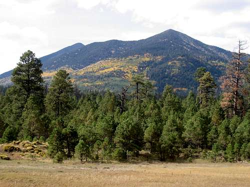
 Fremont is Arizona's 3rd highest mountain. It has the longest approach to its base than any other mountain in the Kachina Wilderness and does not see many visitors. There are also no standard routes. If you climb it you'll probably be the only one on the top.
There are 3 Routes to reach the base of Fremont.
From HWY 89 north of Flagstaff it is the sharpest peak and appears to be the highest.
From Flagstaff it is one of the dominate mountains that overlook the city.
 |  |  |  |  |
Getting There

Elevation gain: 2,649 feet
From Flagstaff take US 180 going to the Grand Canyon. Turn Right on Snow Bowl Rd. Snowbowl Rd is about 7 miles outside of Flagstaff. Continue up the snow bowl Rd for 7 miles. The trail head is below skiing area at a dirt parking lot.
This is not an easy approach as you ascend to about 12,000 feet along the upper part of the Weatherford Trail then descend to the saddle between Agassiz Peak and Fremont Peak. Total accumulated elevation gain to the top of Fremont is about 3,315 feet and total accumulated elevation gain for the entire hike is about 3,981 feet. The hike back up the Weatherford trail is about a 666 feet gain.

Elevation gain: 3,360 feet
Take US 180 heading toward the Grand Canyon. Turn north on Schultz RD (FR 420). Turn left at the intersection with forest Rd 557. Continue on FR 420 for 6 miles to Schultz tank, a small pond.
This route takes you right to the saddle between Fremont and Doyle Peaks.

Elevation Gain: 3,409 feet
From the Flagstaff Mall or I-40 Exit 201, drive north 12 miles on US 89 and turn left (west) onto Forest Road 420, opposite the Sunset Crater turnoff between Mileposts 430 and 431; be in the left lane in order to make the turn. Drive 0.6 mile on Forest Road 420, then turn right on Forest Road 552 and follow it 4.3 miles to Lockett Meadow. Once in Locket Meadow take the road all the way to the far end of the camping area to the trail head. This is a scenic hike into the Inner Basin.
 |  |  |  |
Red Tape
Fremont is off limits due to some very rare vegetation. It only grows here. It is not found on the other San Francisco Peaks. Climbing is off limits during Summer, but is a relatively easy Winter climb, when the crown is covered with snow. Chances of being caught by a ranger are remote but do exist. Local Indian tribes do consider this area sacred, and if caught on the peak could cause you more trouble than a ranger.Camping
Camping is allowed in Locket Meadow. No camping fees. Camping also allowed at Schultz tank. People also camp at the saddle between Doyle and Fremont, but I'm not sure if it’s legal.Mountain Conditions

Live view of the Peaks courtesy of
Rocky Mountain Research Station, Flagstaff Lab
Agassiz (left) and Fremont (right).
Go to the Humphreys Peak web page for more information.
External Links
- San Francisco Peaks web cam
Web cam of the San Francisco Peaks and links to the peaks and FLagstaff
Steven Cross - Apr 4, 2002 6:24 pm - Hasn't voted
Untitled CommentThanks for the info. Where did you find it?
markmay - Oct 12, 2002 11:21 pm - Hasn't voted
Untitled CommentWhere's the sign?
chubb - Apr 3, 2002 3:55 pm - Hasn't voted
Untitled CommentFremont is off limits due to some very rare vegetation. It only grows here. It is not found on the other San Francisco Peaks. Climbing is off limits during Summer, but is a relatively easy Winter climb, when the crown is covered with snow. Chances of being caught by a ranger are remote but do exist. Local Indian tribes do consider this area sacred, and if caught on the peak could cause you more trouble than a ranger.
Steven Cross - Apr 4, 2002 6:24 pm - Hasn't voted
Untitled CommentThanks for the info. Where did you find it?
markmay - Oct 12, 2002 11:21 pm - Hasn't voted
Untitled CommentWhere's the sign?
Andinistaloco - Jan 30, 2006 5:01 pm - Voted 10/10
Untitled CommentWhat I've heard and read contradicts what chubb says.
The vegetation is seneca franciscanus, and it grows not only on Fremont Peak but on all the San Fransisco Peaks. However, it only grows above treeline (~11,500 feet plus or minus 100 or so). This is why you're not allowed to climb Agassiz unless it's snow-covered. Humphreys Peak is permitted because there's long been an established trail to the top, but there are not trails to Agassiz and Fremont, which is why they're off-limits.