
-
 185145 Hits
-
 99.86% Score
-
 151 Votes
|
|
Mountain/Rock |
|---|---|
|
|
27.86170°N / 86.86390°E |
|
|
22467 ft / 6848 m |
|
|
Overview
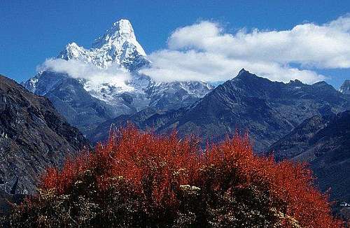
Ama Dablam
Ama Dablam is known as one of the most impressive mountains in the world, not for it's altitude, but for it's beauty, aesthetics and the pure exposure encountered high on it's flanks. Most parties attempt the SW ridge, climbing expedition style, fixing ropes, ferrying loads, and acclimatizing slowly. The mountain has gained in popularity over the past 8 years. It's common to encounter high altitude Everest veterans having problems with the technical difficulties encountered on the crux pitches of this climb.
From Steven Shrader: The climb feels like a 5.8 - 5.9 depending on conditions (Steve has summited 3 times guiding) but it's really hard to say because I (Steve) have always worn plastic boots, and all the climbing is above 6000M. I would have to recommend allowing 5 weeks for this expedition, taking into consideration bad weather, sickness, and multiple summit attempts.
Information about how the peak gets its name from dmiki - Nov 02, 2005 12:57 PM
Mother and her Necklace , Mother’s Charm Box , Mother's Jewel Box
""Ama" means mother, grandmother or even world. "Dablam" means charm box, and is a special pendant worn by elder Sherpa women that holds precious items. The mountain has a hanging glacier that resembles a dablam and the two extending ridges are outstreched like a maternal embrace."
Author: Alan Ellis
Date: May 03, 2005 4:21 PM
Alpinist Issue 10, March 2005, has an outstanding article on Ama Dablam including the climbing history of the mountain, route diagrams, and excellent photographs. Copies of Alpinist 10 can be purchased for $15.00 + $4.00 shipping by calling 1-800-960-0600 or go to www.alpinist.com
Getting There
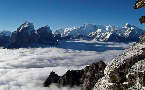
Ama Dablam, around 2 - 3 pm every day,clouds would cover the khumbu at around 4000 m leaving those of us above with a magnificent view.
To get to Nepal you will have to fly from either India, Thailand or Singapore.
To get to New Delhi India try (there are many others).
Air India
British Airways
Air France
Air Canada
Kuwait Airlines
Qatar Airways
Lufthansa
KLM
Royal Air Nepal
Once you get to Katmandu, you will have basically two options:
1 - Fly on Royal Air Nepal’s Twin Otter flights to Lukla - a small air strip about ten days from Everest Base Camp (eight from Ama Dablam Base Camp, allowing for acclimatization) 1 hour flight approx.
2 - Take a local Mini Bus hired by you or your Sherpa provider to Jiri. This is a small village at the end of the road. From here it is about a 14 -16 day trek to the Khumbu region.
If you have the time, do the walk for the following three reasons:
1 - You will have a chance to walk through one of the most lush and beautiful lowland areas in Nepal. This is an area that a lot of trekkers miss when flying to Lukla. You will also cross over two high passes with excellent views in all directions.
2 - By taking 2 weeks to arrive in the Khumbu area, and having already crossed over two high passes, you will be better acclimatized once you arrive in the high peaks area. You will enjoy this more, as you will be huffing and puffing less.
3 - You will be following the route taken by most of the early expeditions. There is a lot of history along that path. Why not soak it up? You will also have the bragging rights that you did the same route they did in years gone by.
Flying is fast and that has its advantages. If you have ever been in Lukla after several days of no flights after bad weather you will understand this. (Trekkers fight over seats to make their connecting flights home)
Note on bus to Juri
Author: vito corleone Date: May 19, 2004 05:08 AM
At the moment it is not possible to take the bus to Jiri. There are no busses going to the east of Nepal from Kathmandu because maoists shot at a public bus and killed several people, including civilians. After that, all the bus services were suspended. Nobody knows when the busses will be going again. If you really want to go to Jiri dispite of the worsening security situation (probably not a good idea) you have to hire a car.
Nepal News
Flying into Lukla 9,350 ft.:
(Note: walking times are approximate. A lot will depend on how you acclimatize.) Slowly descend to Phakding @ 8,700 ft, about a 2 hr walk from Lukla. You will probably overnight here.
The next morning, after about 2-3 hours, you will pass through Jorsale @ 9,100 ft. Here is where you will pay a fee and enter the Sagarmatha (Everest) National Parkland. You will then continue for another 2-3 hours uphill to the main Village of Namche Bazaar @ 11,300 ft. This is quite an elevation gain, especially for those who have flown in. You should rest here one to two days, doing small side trips etc. to acclimatize. When acclimatized, follow the Dudh Kosi along the high trail through Trashinga and the forest nursery to the small village of Pungo Tenga by the Dudh Kosi (10,650 ft). From there, it is a two hour uphill walk to the Gomba of Tengboche (12,687 ft).
This monastery was founded in 1923, but was destroyed by an earthquake in 1934, and again by a fire in the early 1990’s. It has been rebuilt with help from proceeds of the Sir Edmund Hillary fund. The next day (depending on how you are doing) follow the trail east through Deboche (12,325 ft.). Make your way to Pangboche (12,800 ft.). It is a full day hike from here across the river to base camp.
Red Tape
Ama Dablam.
Yes there are permits required. These can be arranged by yourself or the firm that you hire to support your team. There is also an entry visa to Nepal.
The below can be of help.
Permits
The General Secretary,
Nepal Mountaineering Association
Post Box No. 1435,
Kathmandu.
As well, other fees apply; i.e. Liaison Officer, cooks, high altitude Sherpas, insurance for the expeditions employees etc. Be aware of the dates where there are no summit blackouts. You can be on the mountain, but are not allowed to summit. Rules are very strict in the Khumbu Park. You will have to make a $2,000.00 deposit for your garbage, and have it inspected to satisfaction upon completion of your expedition to get your deposit back. There are absolutely no fires allowed by westerners at Base Camp. If you burn your T.P., you loose your garbage deposit. Human waste is a major problem. This is something that should be well planned out on how to deal with so the mountain doesn't become more contaminated. One way to deal with it, leave camp, do your business on a nice saucer rock and huck that puppy. Unfortunately, the best way to deal with it is the same way Big Wall climbers in Yosemite do it and carry it down. Also, please carry all your garbage off the mountain.
When To Climb
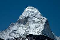
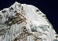
Ama Dablam. Close shot of Ama Dablam seen from Island Peak
For trekking: October to end of November are the most popular because of good visibility. The monsoon has cleared the air of dust. January to end of March is the next most popular as it gets hazy near the end of March due to dust from the plains of India.
October thru November
Author: ColdMountain
While trekking is most popular during post-monsoon, few climbers are tackling the peaks, except for some of the trekking peaks like Imja Tse, Mera, Pancermo, Ramdung, etc. Ama Dablam is a good climb post-monsoon, and a completely different mountain than in the spring pre-monsoon. Less snow, more hard ice, and much rock. For those hard enough to take on the North Ridge, the fall is best. The normal Southwest Ridge is a real classic in the fall, with stable rock, firm ice and flutes that are real natural works of art. The days are clear, warm, and crisp with the chance of snow later. As the season moves on, it will get much colder in the evenings (especially at base camp), making the ice harder and snow more consolidated.
Climbing: April to mid-May.
You should be prepared for all types of weather. The evenings will be cold for sure, but the daytime can be hot even at altitude. Be prepared for rain, sleet, snow, heat and leaches.
June and July
Mud, heat, rain, rain and for sure leaches.
Guided climbs
climbers on Ama Dablam - October 22, 2004. Believe them to be of the Summit Climb group led by D. Mazur
Most of these groups guide in the Khumbu.
- Alpine Ascents International
- Adventure Consultants
- Himalaya Expeditions
- Earth Treks
- Fieldtouring
- Jagged Globe
- Mountain-Link Expeditions
- Mountain Madness
- Mountain Odyssey
- Ascending path
- Ganesh Adventures
Helping the Sherpa community
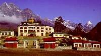
There are several organizations dedicated to helping the Sherpa community. Here are just two. Should you wish to contribute to this worthwhile cause contact either of the following organizations though the information below.![TengBoche monaster !]()
Tengboche Monastry
The Sir Edmond Hillary Foundation
222 Jarvis Street
Toronto, Ontario, Canada
M5B 2B8
(416) 941-3315
The American Himalayan Foundation
The American Himalayan Foundation
909 Montgomery Street, suite 400
San Francisco CA 94133
Telephone (415) 288-7245
Fax (415) 434-3130Avoiding Altitude sickness
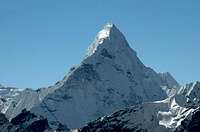
You should be prepared for the possible onset of altitude sickness. High altitudes are stressful on the body, and lack of oxygen up high can produce slightly debilitating effects, such as fatigue, headaches, shortness of breath, loss of appetite, nausea, and a drunken gait. Altitude sickness generally doesn’t occur below 10,000 feet, but people have suffered its symptoms lower than 8,000 feet.![Sunrise on Ama Dablam seen...]()
Sunrise on Ama Dablam seen from Dingboche, May 2005. Photo by mblue01.
There’s not much you can do to prevent this problem, but there are ways of alleviating its effects. The key to doing this is simple: take it easy. Take a day or two before beginning the walk in to acclimatize yourself to the elevation. Go at your own pace, and don’t take chances. Even if you’re in excellent shape, don’t be fooled. The lack of oxygen at such high altitudes can definitely throw your lungs for a loop. Walk at a comfortable, slow pace and don’t carry too much weight. Make sure to hydrate yourself regularly, drinking 4 to 5 liters (nalgene bottles) of water per day; On some climbs camelbacks can be mountain companions because of their convenient water portability. The only problem being keeping the nozzle clean, I find they can get gross and need constant cleaning. Myself, I attach a 1 litre Nalgene bottle to each side of my backpack so that I can reach them easily without removing my pack. These solutions would have to be modified to suit the weather and conditions of climbing Ama Dablam. Bottles would have to be insulated and the tube from the camelback could tend to freeze up. Taking antioxidant vitamins (A, C, and E) also helps reduce the effects of high altitudes. Of course working out before you go is another great preventative measure. While this doesn’t guarantee an easier time when up high, it can enhance your lungs’ ability to cope with the challenges of high elevations.
Try to spread out your ascent over a period of two or three days to give your body more time to adapt. Play by the “climb-high, sleep-low” theory of ascent: go on a short hike to a higher elevation, then return to the (lower) elevation at which you’ll sleep.
Physical fitness, as mentioned above, is no guarantee against developing altitude sickness. Past excursions to high elevations without developing symptoms is similarly no guarantee against getting sick. There’s no way to predict who is more susceptible to altitude sickness, although climbers who overexert themselves, those who are panting or breathless, and those who stagger far behind the rest of the group are likely candidates.
Surefire signs of impending illness include extreme fatigue, headache,
loss of appetite, and shortness of breath. If you experience any of these symptoms, the best thing to do is take a break from climbing for a couple days to acclimatize. Once the symptoms disappear, it’s safe for you to continue. If the symptoms persist or get worse, you should descend to a lower elevation.
More serious levels of the illness include increasing tiredness, severe headaches, vomiting, and loss of coordination, and are indicative of acute mountain sickness (AMS). If such symptoms appear, don’t hesitate to get immediate medical attention. If serious symptoms go ignored for more than 12 hours, they could have dire--even fatal--effects, such as accumulation of fluid in the lungs or brain. The most important symptom of AMS is loss of coordination. If someone staggers or walks in a drunken gait, check them out for further signs of AMS. A good test is, essentially, the police’s test for drunkenness--ask the person to walk in a straight line, placing one foot directly in front of the other without staggering or losing balance. If the person cannot perform, he or she should descend immediately--and never alone. Go slowly and without exertion, and ideally while it’s light outside. Descend should continue until symptoms begin to decrease; relief usually occurs within 1,000 to 1,500 feet.
There are prescription drugs out there that you can take for severe symptoms. One of the most common is called Diamox; it works by stimulating your breathing. Diamox is a strong medication and has some slight side effects, such as an annoying tingling in the fingers and toes. You will urinate more frequently so getting out of the tent at night in a storm could be a problem (if you don’t use a pee bottle). This will also necessitate you dringing more fluids to compensate. If you take too much I have seen people get very ill. I avoid taking it if if I can.
Equipment list (partial)
Partial Equipment list info:![A sunset view of Ama Dablam...]()
A sunset view of Ama Dablam from Thangboche Monastry in 1986.
Here is a brief incomplete list for you. Minus the Climbing gear - 6-pairs socks
- 6-underwear
- 2-pairs of shorts for the walk in
- 3-T-shirts for the walk in
- 2-bandanas or a sun hat to keep off the sun
- Sunscreen, sunscreen, sunscreen plus zinc
- Good sturdy hiking shoes
- 1-sleeping bag (as warm as you can get)
- 1-sleeping pad (your choice the more comfortable you are the better you sleep the more energy you will have) you can get a Crazy Creek chair that goes with your pad this is a good investment.
- 2-expedition weight Patagonia long underwear tops (or 1 depends on how dirty you like to be)
- 1-expedition weight Patagonia long underwear bottom
- 1 lightweight fleece bottom
- 1-heavy weight Patagonia or similar fleece jacket
- 1-Gortex shell jacket
- 1-Gortex shell pants (full length zippers)
- 1-Down filled jacket liner from Feathered Friends of Seattle, (optional but I always end up using it)
- 1-Downfilled Gortex guides Parka 1-Warm hat with ear flaps
- 2-pairs of heavy duty mittens (in case you lose one pair up high)
- 1-pair fleece gloves 1-pair ski gloves
- 1-pair of Koflach double plastic boots, One Sport (warmer)($$$) or Asolo (I prefer Koflach, I find them more comfortable)
- 1-pair of gaitors
- 1-pair ski poles
- 1-ice axe
- 1-pair of sharp crampons (test them on your boots before you leave and make sure they fit perfectly)
- 1-headlamp with extra batteries and bulbs
- 1-cup with spoon attached
- 1-Swissarmy knife
- 1- stove of your choice (I use Markhill stormy hanging stone with Blueway cartridges, you will have to get fuel in Nepal as it is difficult to fly over) Allow at least 1 canister per day for up high per 2-man tent.
- 1-3 tents one set up at base camp. one at camp 1, perhaps another for higher up.
3-1-litre waterbottles with insulators (drink at least 5 litres a day to help acclimatize)
Food....
Some Firsts
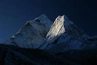
NW-ridge first ascent![Ama Dablam North Ridge....]()
Ama Dablam North Ridge. Closeup as seen from trail Lobuche to Kala Patthar (October 2004).
First - and so far only - ascent of the total NW ridge via the fore-summit (6181 m) by Jules Cartwright and Rich Cross (GB) done in alpine style during 11 days in November 2001 more to read here on scotlandonline.com
scotlandonline.com
First ascent: Michael Ward.
1961 - Michael Ward did the 1st ascent of Ama Dablam with two other scientists Mike Gill (New zealand), Barry Bishop (USA), and Wally Romanes (New Zealand - The 'mechanic' in charge of maintenance and repair).
Scroll down to the bottom of the story below for a description. Supplied by Summitpost member ericvola
https://www.summitpost.org/everest-michael-ward/779004
Political situation
Note on Nepal. Note on Nepal. There had been a cease fire and talks between the Government and the Maoist who were causing issues in parts of the country. This has led to them being included in the government. Lets hope this coalition holds so that locals, trekkers and climbers can all enjoy this wonderful place in peace.![Mushroom ridge on Ama Dablam SW-Ridge]() Tuomas Sovijärvi (Fin) balancing on the knife-edge narrow Mushroom ridge leading to camp III on Ama Dablam regular route (SW-ridge).
Tuomas Sovijärvi (Fin) balancing on the knife-edge narrow Mushroom ridge leading to camp III on Ama Dablam regular route (SW-ridge).
More photos: www.samulimansikka.com
External Links
![From Kala Pattar]()
Ama Dablam, February 1986, from Kala Pataar.- A personal site with pictures, video and stories about climbing big mountains around the world
Mountains include Cho Oyu, Ama Dablam, Denali, Grand Teton, Longs and more. - Personal site of Alpine mountaineering
My site has tirp reports, pictures, videos and stories of my climbs to Ama Dablam, Cho Oyu, Denali, Everest and more. - The Ascending Path LLC
Spring and Fall 2003 expeditions. - Ama Dablam Alpine Style 2005 Expedtion
Our site is about international, non-commercial expedition which will take place in October-November 2005. - A Successful climb in nov-2005
- Ama Dablam trip report
Useful Updates
http://www.alanarnette.com/phpBB3/viewtopic.php?f=3&t=126&p=354#p354 - A personal site with pictures, video and stories about climbing big mountains around the world


dmiki - Nov 24, 2008 1:29 pm - Voted 10/10
useful updateshttp://www.alanarnette.com/phpBB3/viewtopic.php?f=3&t=126&p=354#p354
William Marler - Nov 27, 2008 10:30 am - Hasn't voted
Re: useful updatesHi I added the link in the link section. Alan already has a link there from before. Perhaps this is different. I will check them both out when i have a moment. Thanks and cheers
blakeatt12 - Nov 3, 2018 5:16 am - Hasn't voted
Flights & RocksThere are a lot of ways to fly to Kathmandu. I flew in from Istanbul. Also I just summited and the rocks on the Gray Tower are NOT stable. Serious rock fall danger if you have people far ahead of you. TV sized rocks came within 15 feet of me.