
-
 64347 Hits
-
 95.51% Score
-
 53 Votes
|
|
Mountain/Rock |
|---|---|
|
|
39.42310°N / 106.1228°W |
|
|
13950 ft / 4252 m |
|
|
Under New Management
Hi everyone, the previous owner of this page has decided to move on from Summitpost and is in the process of transferring pages to new owners. As such, I have agreed to adopt this page.
I took over on March 7, 2012, along with several other pages. This page is completely new and reformatted minus a few links towards the bottom. I hope you find the new page as informative and useful as the old one, please feel free to leave any comments you have.
Happy hiking!
"Chicago Transplant"
Overview
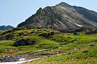
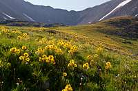
Pacific Peak lies on the crest of the Tenmile Range along a high stretch of peaks spanning between Breckenridge and Hoosier Pass in the Breckenridge quadrangle. Standing at 13,950', Pacific just misses out on being one of Colorado’s “Fourteeners”, but as one of Colorado’s Highest Hundred peaks, otherwise known as the “Centennial Thirteeners”, its height and ease of accessibility make it a popular climb none the less. Pacific is Colorado’s 61st highest peak and rises with 570' of prominence from its “parent” peak 1.4 miles to the south, Fletcher Mountain.
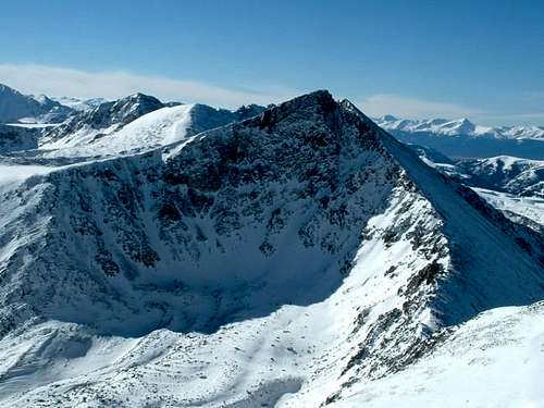
With its pyramidal shape and distinctive notch near its summit, Pacific sets itself apart from its neighbors and is easily recognizable from not only neighboring summits, but from the roads in the area. In particular, when traveling along I-70 near Copper Mountain ski resort, Pacific is quite noticeable and inspires many - climbers and non-climbers alike.
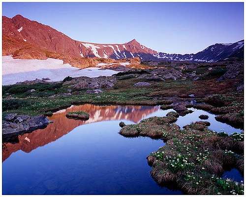
One other distinction for Pacific, is that on its southeast side lies a high tarn that is quite possibly the highest lake in Colorado, if not the lower 48, at 13,420' above sea level. This small lake, called Pacific Tarn, is often rimmed with snow and ice well into summer and sits on a high plateau at the west end of a narrow ridge that separates McCullough Gulch from Spruce Creek.
Several of Pacific's neighboring peaks work well in combination climbs, including Crystal Peak, Atlantic Peak, and Fletcher Mountain.
Getting There
Access to Pacific Peak is easily achieved from either Colorado State Highway 91 on the west, or Colorado State Highway 9 on the east. Both roads are paved and serve as major access roads from I-70 to points southward. From these two roads, several high trailheads can be reached that provide access to a variety of routes on Pacific, and its neighboring high peaks.
McCullough Gulch Trailhead:
This trailhead is located near the trailhead for the popular fourteener, Quandary Peak. Follow Colorado 9 south from Breckenridge for about 8 miles to the Blue Lakes Dam Road (850) and then take the quick right onto Road 851, signed for access to Quandary Peak. Continue past the parking area for Quandary Peak as it curves around the east and north sides of Quandary ending at a gate at 11,080' about 2 miles past the Quandary trailhead.
North McCullough Gulch Trailhead:
About a mile and a half beyond the Quandary trailhead, look for a turn to the right, descend and cross McCullough Gulch and climb to the end of the road at 11,050' - 3/4 of a mile from the turn. This trailhead provides good access to Pacific’s east ridge.

Spruce Creek Trailhead:
To reach this trailhead, follow Colorado 9 south from Breckenridge for about 2.5 miles to Spruce Creek Road and turn east. The gravel road travels through a residential neighborhood until a parking area about 1.2 miles at a road split at 10,380'. This is a good place to park passenger cars, and this trailhead is accessible in winter. From here, higher clearance vehicles can continue on the left (south) of the two roads until it ends at 11,080' - about 3 miles from Colorado 9. This is also the trailhead for the popular local hike to Mohawk Lakes.
Mayflower Gulch Trailhead:
To access the west side of Pacific Peak, follow Colorado 91 south of I-70 about 6 miles south of the exit, or 4 miles north of Fremont Pass. There is a large parking area at 10,980' just off the highway that is plowed in winter, and popular with all sorts of winter recreationalists. In summer higher clearance vehicles can continue along this road for a mile and a half to the old Boston Mine site at 11,560', but really if Pacific is your objective, its best to stop sooner to access Pacific Creek.
Routes Overview
Pacific has a wide variety of routes from its numerous trailheads. Its summit can be reached from each of its four ridges, or from the north couloir - one of the finest mountaineering routes in the Tenmile Range. See the links at left for additional routes, a summary of some of the more popular routes are below.
Northeast Slopes:
10.6 miles round trip, 3570' vertical from Spruce Creek 2WD parking.
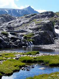
This is typically the easiest route from the east, but it can be a challenge to reach the ridge, either requiring a moderate snow climb, or an ascent of a steep loose talus and scree gully when dry. From Spruce Peak, hike or drive the road to the Mohawk Lakes trail and climb this trail past a waterfall and several lakes. Once past Upper Mohawk Lake the trail fizzles out in the tundra as you head towards an unnamed lake at 12,391'. Come around the north side of the lake and up a steep gully (snow in spring) to the high plateau where Pacific Tarn resides. Come around the right side of the tarn to gain the southeast ridge and follow it to the summit. You can descend the route, or head over neighboring Crystal Peak.
South Ridge:
7 miles round trip, 2950' vertical from McCullough Gulch.
Similar to the southeast ridge, this route also requires an ascent of a snow slope much of the year. From the parking area in front of the gate, follow the road briefly looking for a trail on the left where the road take a switchback east. Follow this trail to a high lake at 11,900' on the north side of Quandary and then work your way through a series of lush benches to a high bench at 12,600' below Atlantic and Pacific. To reach the south ridge from here, you will have to more than likely climb a snow slope for 400' before the slope eases and reaches the Atlantic-Pacific saddle, from here follow the south ridge to the summit. You can descend the route, or head over neighboring Atlantic Peak.


East Ridge:
6.8 miles round trip, 2970' vertical from North McCullough Gulch.
Scamper up a steep southeast facing ridge to 12,200' and a wide grassy slope that leads to the ridge crest at 12,800'. Scramble across the narrow ridge for about a mile to the high plateau that hosts “Pacific Tarn”. The ridge provides some exposure, route finding challenges, and moderate scrambling and is a good introduction to third class ridge scrambling. From Pacific Tarn, finish on the southeast or south ridge.
North Ridge:
7.2 miles round trip, 2970' vertical from Mayflower Gulch 2WD parking.
Follow the Mayflower Gulch road for about a mile, leave it and head towards the south side (right) of Pacific Creek, crossing Mayflower Gulch through a willow filled basin. Contour below the west ridge of Atlantic, and around the west ridge of Pacific across a high plateau below the northwest face of Pacific. Climb up a rocky slope to the Pacific-Crystal saddle at 13,220' and climb the north ridge to the summit. Just below the summit you will cross the notch that helps give Pacific its unique shape, and get a view down the north coulour. You can combine this ascent with Crystal or Atlantic, or both. This is generally the safest route for winter.


West Ridge:
5.8 miles round trip, 2970' vertical from Mayflower Gulch 2WD parking.
Follow the Mayflower Gulch road for about a mile, leave it and head towards the south side (right) of Pacific Creek, crossing Mayflower Gulch through a willow filled basin. Contour below the west ridge of Atlantic, and around to the base of the west ridge of Pacific. This ridge can be kept at class 3, but requires some route finding to avoid some more significant rock towers along the way. These by-passed may put you into some loose rock, so bring a helmet if in a larger group. Descend the north ridge, or via Atlantic’s west ridge for a nice loop.
North Couloir:
10.5 miles round trip and 3570' vertical from Spruce Creek 2WD parking.
Follow the northeast slopes route, but continue past the lake at 12,391' to the base of the 700' couloir. The couloir steepens to 65 degrees and can hold sections of either alpine ice, or 5th class rock (5.5) as it melts out later in the season. The couloir finishes at the notch in the north ridge, descend the northeast slopes route, or via neighboring Crystal Peak.


When To Climb
When to climb? Well, Pacific can be climbed whenever you feel the need to get some altitude. The peak is accessible year round, but not without precaution. In spring snow on the access gullies may require the use of an ice axe and crampons. In summer, you will want to be off the summit early to avoid afternoon thunderstorms that frequent Colorado. In fall, the gullies have melted to loose rock. In winter the best route is typically the north or west ridge routes from Mayflower Gulch, both which cross potential avalanche slopes in Pacific Creek or on the northwest face of Pacific. You can mitigate the avalanche danger in Pacific Creek by going over Mayflower Hill, but that small peak can form some serious cornices on the north side that need to be avoided. Take all of these notes into consideration when planning your outing to Pacific, and don’t forget to check out some of the neighboring peaks while you are up there, they combine well.
Camping/lodging
There are lots of opportunities for camping near the peak, there are some small pullout campsites available along most of the roads, but due to the residences around Spruce Creek, its best to be above the 2WD parking before you camp. You can hike in along any of the trails and find some opportunities as well, but Pacific and its neighbors generally lend themselves to being single day outings with their high trailheads and easy access.
There are also several options for lodging of all kinds in the nearby towns. Summit County is a recreational hub in all seasons, and attracts many visitors each year - particular during ski season. South of Fremont Pass, Leadville is another option. Here are some links to the local towns:
Frisco
Breckenridge
Breckenridge Resort
Leadville
 |
 |
 |
Mountain Conditions and Red Tape
WEATHER AND MOUNTAIN CONDITIONS:
Check the below links for weather and avalanche conditions in the areas around Pacific Peak.
Regional Forecast
GOES Western US Satellite Image
Avalanche Conditions
 |
 |
 |
 |
 |
RED TAPE:
Pacific really doesn’t have any red tape issues, the land is public and the peak is accessible from all sides, and in all seasons. It provides a great outing for people who want to get up a high peak without a lot of effort. The peak resides in the Arapahoe National Forest.
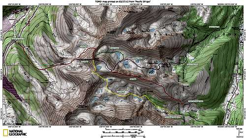
Topographical Map
Click to enlarge
 Regional Map
Acknowledgements
Special thanks to the original page author's Kane and Aaron Johnson. Additional thanks to the book "Colorado's Thirteeners from Hikes to Climbs" by Gerry and Jennifer Roach. Statistical information is from the website Lists of John. Also, thanks to all of YOU for your great photographs, routes, and trip reports! Keep them coming!