
|
|
Mountain/Rock |
|---|---|
|
|
38.28620°N / 119.6512°W |
|
|
Hiking |
|
|
Summer, Fall |
|
|
11569 ft / 3526 m |
|
|
Overview
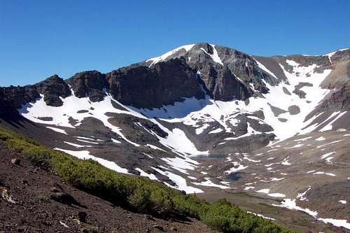
Leavitt Peak is a broad rounded peak located south of Sonora Pass accessed from California State Route 108, one of the 3 trans-Sierra routes closed during the winter. There are several peaks in the area that can be summited in a day or less, but Leavitt Peak is the highest. It is located south of the pass in the Emigrant Wilderness and is a nice side trip for those traveling the Pacific Crest Trail (PCT). Leavitt Peak offers views south towards Yosemite and North towards the South Tahoe high country. Summer weekends can be a busy time in this area with quite a few people making the summit.
Leavitt Peak isn't technical, but it requires a full day from the most direct route via the PCT. It can easily be combined with Pacific Crest Peak 11,245'.
 |
 |
 |
 |
 |
Getting There
For the primary route at Sonora Pass, it is fairly easy to access.
From the east the summit / trailhead parking area is approximately 14 miles west of the junction of U.S. 395 and CA State Route 108.
From the west the parking area is approximately 50 miles east of Sonora, CA on State Route 108.
There are other options, the most popular alternative is to hike from Leavitt Lake. That turnoff is about four miles east of Sonora Pass.
Red Tape
There are no permits required for day hiking in the Emigrant Wilderness or parking at the trailhead. A Wilderness Permit is needed if camping in the Emigrant Wilderness. An online permit form for a Wilderness Permit is available. Permits can also be obtained from any Stanislaus National Forest Ranger Office. Permits can also be obtained from any National Forest Ranger Office including the Mi Wok and Summit Ranger Stations offices located along CA State Route 108 en route to Sonora Pass from the west. Only one permit is needed for continuous trips passing through more than one wilderness area. If you plan on using a stove, even if on a day hike, a fire permit is required and can be picked up at any U.S. Forest Service office. The fire permit is good for the entire state of California.
Also note that Leavitt Lake and the Leavitt Lake Road are managed by the Humboldt-Toiyabe National Forest and is within the Hoover Wilderness. Most hikers approach from Sonora Pass, however, just be aware if approaching from Leavitt Lake or camping by Leavitt Lake that this area is managed differently and follow the Hoover Wilderness rules and regulations. There are no restrictions for a day hike from Leavitt Lake.
When To Climb
The best time to hike/climb is generally early July through early October. The pass is usually closed from 7 miles east of Strawberry to 5 miles west of the junction with U.S. 395, from the first significant fall / winter snowfall until late spring. Memorial Day is the usual target date for opening the pass. Some years it has been earlier and some years later. Since the primary route to Leavitt Peak is from the north side, it gets a lot more snow than nearby Sonora Peak 11,459' which is approached from the south.
Camping
Camping is allowed in the Emigrant Wilderness with the proper permit. There are several Forest Service campgrounds nearby that are free for camping. The catch is there is no water available. Further down from the pass in both directions are regular Forest Service fee campgrounds. There are also a couple of stores and restaurants fairly close to the west at Kennedy Meadows and Dardanelles. Leavitt Lake is a camping option. More details are found at the Leavitt Lake Trailhead page.
Mountain Conditions
Current highway conditions can be found on the Caltrans website or by phoning the California Department of Transportation road condition line at 1-800-427-7623. General area conditions can be found by phoning any Stanislaus National Forest Ranger Station.
Sonora Pass weather is found here.
 |
Etymology
"Hiram L. Leavitt built a hostelry in 1863 at the foot of the east end of Sonora Pass to serve the traffic between Sonora and Aurora. (Maule.) Leavitt was also an early Mono County Judge. (Farquhar from Judge Parker, Bridgeport, 1928.) "Leavitt's" (for the peak) is on Hoffmann's map of 1873 and the Wheeler Survey atlas sheet 56D, 1878-79. On the 1875 GLO plat, the creek is called 'West Fork of West Walker River.' The meadow is mentioned by name by Lt. Macomb in 1878. The peak, creek, and meadow have their present names on the first Dardanelles 30' map, 1898. The other names do not appear until the 15-minute quad, 1956."
- Peter Browning, Place Names of the Sierra Nevada