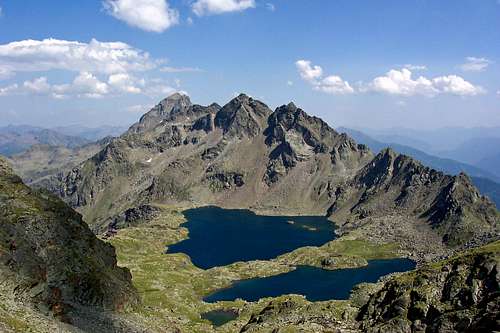
The Schober group lies south of Grossglockner group and is considerably lower, so also covered with less glaciers. Still, 53 peaks exceed 3000 m, some of them are very beautiful and attractive for mountaineering. Only few mountains have easy ascents, many main mountains demand climbing skills in loose but exposed rocks and are not climbed often. Because of these difficulties author Liselotte Buchenauer named the Schober Group as “Western Alps of the little man”. In the mountaineering respect, the region is well developed, mountaineering is supported by 8 mountain huts, but still you will be able to find there also remote and lonely places. Besides some nice summits an attraction are also some high area with mountain lakes, like Wangenitzsseen, Neualpseen etc. Group is named by Hochschober, 3242m, its most beautiful summit. But it is not the highest one. Petzeck, 3283m exceeds it by 41 meters and also Rotterknopf, 3281m. Besides these three, well known summits are also Gloedis, 3206m Boeses Weibl, 3119m and others. In distant past, the well known Salzburger Ludwig Purtscheller (1849-1900) did a lot for discovering the group. From July 24th to August 3rd, 1690 he summited 35 peaks in Hochschober group and made it known by writing a monography about it.
The Hochschober
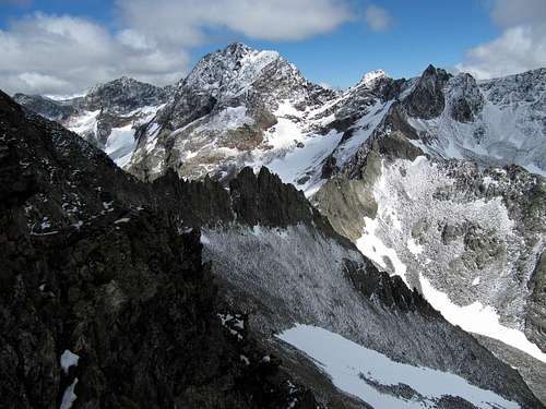
Schober group seen from the top of Grossglockner
Geography
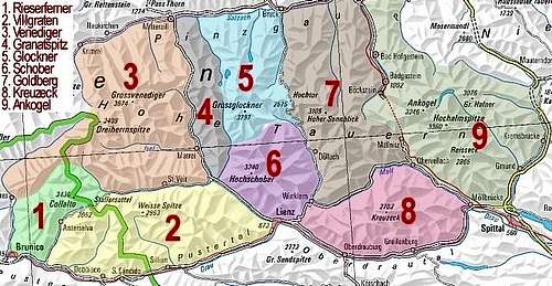
Schober group. Numbers by...
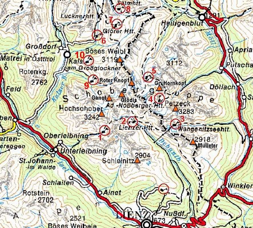
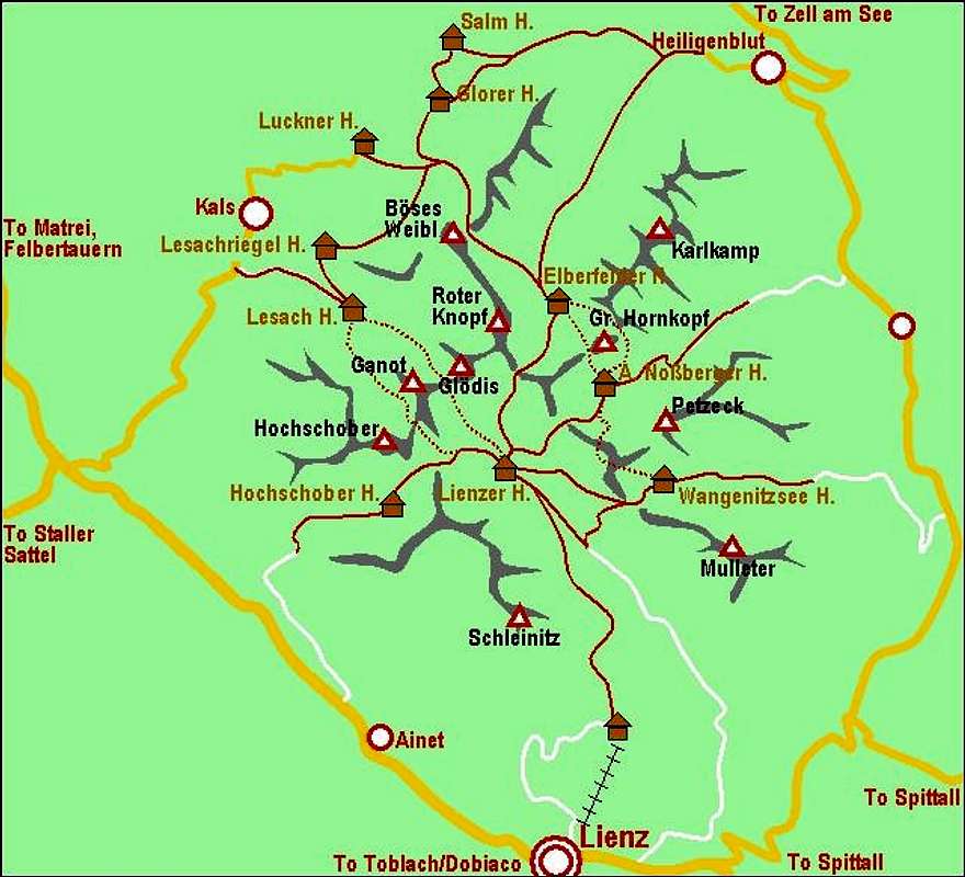
A map of Hochschober group. Numbers by huts correspond to those in text (see below).
The southern border of Schober group is Isel valley with Lienz, then short part of Drau valley, the eastern border is Moell valley. On the north and north-west the group is more closely attached to other groups of Hohe Tauern. On the north-west, the valley of Kalser Bach lies between Schober group and Granatspitz group, while on the north beyond Berger Toerl Grossglockner group begins.
The longest valley, extending into the group is Debanttal, coming from the south east. In it, Lienzer hut stands. The majority of group main summits encircles this valley. The other valleys are shorter. From the east and north-east three valleys extend into the group: The valley of Wangenitzbach, the valley of Gradenbach and Goessnitz valley. At the end of each, a mountain hut stands. From the western side a beautiful Lesachtal reaches the Hochschober north face glacier. And let me finally mention also the valley of Leibnitzbach, extending into the group from the south-west and hosting the Hochschoberhuette.
Besides the north face of Hochschober, small glaciers are also covering some north parts of other higher summits in the group. You should consider this, when planning tours, especially in early summer.
Maps: On-line, you can see a detailed map on: http://www.austrianmap.at/. The best classical map is Alpenvereinskarte (map of the german alpine club) Nr. 41 Schobergruppe 1:25.000, can be ordered at DAV Shop (online shop) - click here. Freytag & Berndt: Kals, Heiligenblut, Matrei 1:50000 (Nr. 181). Kompass, No. 39: Grossglocknergruppe - NP Hohe Tauern. 1:50000.
Getting There
A self-made map of Hohe...
For general orientation see the general Hohe Tauern page. Lienz can be reached from the north through Felbertauern tunnel, from the south (from Italy) by Drau river valley or over Staller Sattel (saddle), 2050 m, or from the east by Drau valley - from Spittal, where you leave the Villach-Salzburg highway. Heiligenblut can be reached from the north over Hochtor (Pass), 2504 m, and from the east by Moell and Drau valley - from Spittal, where you leave the Villach-Salzburg highway.
What to do there?
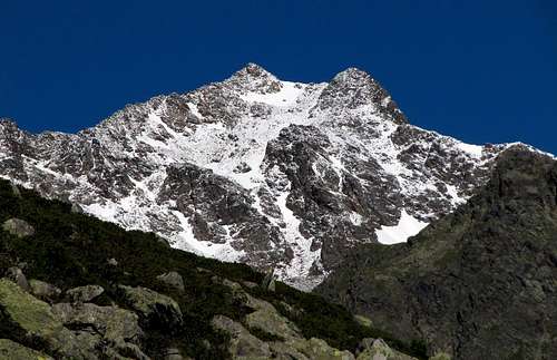
The Roter Knopf
A few mountaineering proposals:
Crossing the Hochschober, 3242 m. An elegant summit with a beautiful glacier.
Normal route on Petzeck, 3283 m. Massive highest peak in the group, nice area around Wangenitzsee (lakes).
Normal route on Roter Knopf, 3281 m and Boeses Weibl, 3121m. Massive rock mountain and an elegant north outpost.
Normal route on Gloedis, 3206 m. A sharp cone peak in the middle of the group.
Normal route on Hoher and Niederer Prijakt, 3064 m, 3056 m. Nice formed twin peaks, south of Hochschober.
Normal route on Schleinitz, 2905 m. The house summit of town Lienz. Nice area around Neualpseen (lakes).
Normal route on Schoenleitenspitze, 2810 m. A grassy balcony above Lesachtal.
Very nice to do is a hiking round trip through the group from hut to hut with climbing some of the easier summits. Some of these marked routes also demand alpinistic skills and good (free of snow) conditions (esp. between Wangenitzsee, Nossberger and Elberfelder hut). Valleys in the group are themselves nice hiking goals. Very often visited is also the grassy balcony above Lienz, called Zettersfeld, which offers a magnificient panorama on Lienzer Dolomiten, a limestone group, standing beyond the Drau valley. Zettersfeld can be reached by cable-car or by a toll-free road.
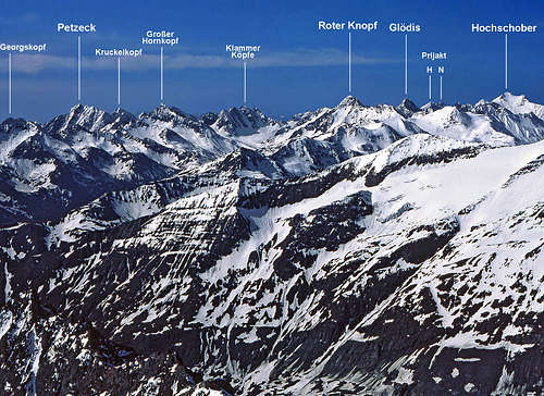
Schober Group annotated
A few tour skiing proposals:
Hochschober north face (difficult, 50 degrees!),
Boeses Weibl,
One of the summits from Goessnitz valley: Sukopf, 2749 m, Gremul, 2909 m, Zinketz, 2973 m, Roter Knopf, 3281 m, Boeses Weibl, 3119 m, Goessnitzkopf, 3096 m,
One of the summits from Graden valley: Weisswandspitzen, 2916 m, Klammerkoepfe, 3126 m, Kleiner Hornkopf, 3194 m, Keeskopf, 3081 m, or even Petzeck, 3081 m.
Guidebooks (please add info!):
The most detailed German guidebook is: Walter Mair, Schobergruppe, Bergverlag Rother Muenchen, 1979, ISBN 3 7633 1222 6, out of print.
Two more resources: Sepp Schnuerer. Hohe Tauern. BLV, Muenchen. 1990. Manfred Korbaj. Kaerntner Schitourenfuehrer. H. Weishaupt Verlag, Graz. 1990.
The slopes above Lienz - Zettersfeld - are an attractive ordinary ski resort. There are also ski resorts around Kals and Heiligenblut (not belonging to Schober group). The most known tourist resorts in the region are: Heiligenblut, Lienz, Kals, Ainet, and others.
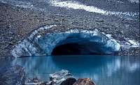
The Landscape Of Beautiful Mountain Lakes
In Schober Group there are many areas of beautiful mountain lakes. You are welcome to contribute more pictures.
Mountain Huts and Camping
A self-made schematic map of...
A map of Hochschober group with all the official hits marked
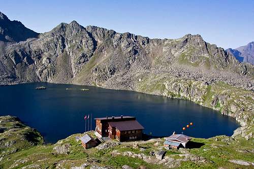
Wangenitzsee hut
Hochschoberhuette, 2322 m. Opened from begin June till end of September. 12+45 beds + 6 in winter room. Tel. 0664/9157722. From Ainet 5 h, from end of the road in Leibnitztal 2h 39min.
Lienzerhuette, 1977 m. Opened from mid June till end September. 37+58 beds + 10 in winter room (key: Alpine Club). Tel. 04852/69966. From the end of the road in Debanttal 1 h.
Wangenitzseehuette, 2508 m. Opened from mid June till mid September. 30+34 beds + 10 in winter room (opened). Tel. 04826/229. From Iselsberg 5 h, from Moertschach 5 h, from the end of the road in Debanttal 2 h 45 min.
Adolf-Noßberger-Huette, 2488 m. Opened from begin June till end of September. 14+22 beds + 8 in winter room (key: Alpine Club). Tel. 0664/9841835. From the end of the road in Gradental 2 h 30 min to 3 h.
Elberfelder Huette, 2340 m. Opened from begin July till mid September. 12+46 beds + 5 in winter room (opened). Tel. 04824/2545.
Lucknerhaus, 1920 m. Opened from begin February till end October. 32+20 beds. Tel. 04876/8555. Reachable by car from Kals (for road you pay toll).
Glorer Huette, 2462 m. Opened from end June till begin of October. 14+48 beds + 4 in winter room (opened). Tel 0664/3032200. From parking place at Lucknerhaus (for road you pay toll) 2 h.
Salmhuette, 2644 m. Opened from mid June till begin of October. 30+31 beds + 6 in winter room (opened). Tel (+FAX) 04824/2089. From Heiligenblut 5 h, from Glocknerhaus 3 h, from parking place at Lucknerhaus (for road you pay toll) 3 h.
A. V. Jugendheimhuette on Zettersfeld, 1903 m. Tel. 0043 1 563420.
Lesach Huette, 1828 m. Opened from June to September. Tel.: 0043 / 0663-9759996.
Lesachriegel Huette, 2120 m. Opened from June to September. Tel.: 0043 / 04876-265.
There are no limitations for reaching summits. Also roads into the group are toll-free, except from Kals to Lucknerhaus. The Schober group is part of National Park Hohe Tauern.
Outside links
Christof Simon: Rote Knopf, Glödis and Hochschober.
Vid, I suppose to
- fake the height of the group 1 feet higher so that the page stays always ahead of Petzeck at the page list
- delete the coordinates for the group that are the ame as for Petzeck
Mathias
Children refers to the set of objects that logically fall under a given object. For example, the
Aconcagua mountain page is a child of the 'Aconcagua Group' and the 'Seven Summits.' The
Aconcagua mountain itself has many routes, photos, and trip reports as children.
Parents refers to a larger category under which an object falls. For example, theAconcagua mountain page has the 'Aconcagua Group' and the 'Seven Summits' asparents and is a parent itself to many routes, photos, and Trip Reports.

 23952 Hits
 86.85% Score
 23 Votes
 Sepp Schnuerer. Hohe Tauern. BLV, Muenchen. 1990. Manfred Korbaj. Kaerntner Schitourenfuehrer. H. Weishaupt Verlag, Graz. 1990.


Mathias Zehring - Oct 28, 2005 3:23 pm - Voted 10/10
Untitled CommentVid, I suppose to
- fake the height of the group 1 feet higher so that the page stays always ahead of Petzeck at the page list
- delete the coordinates for the group that are the ame as for Petzeck
Mathias