June 14th, 2008 - Pictures attached/detached, minor text additions.
July 26th, 2005 - A complete redesign: One chapter for each major mountain added.
Overview
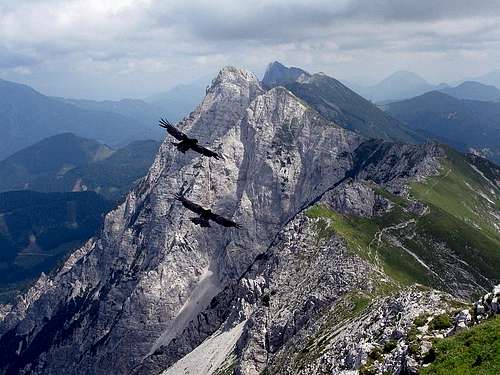
Branko - The view from Veliki vrh along the Košuta range
The name
Because of pronounciation I shall write here the name of this mountain as it is written in German. Otherwise the name is Slovenian (Košuta), and means a hind.
General
Some 120 km longe range of Karawanks mountains (karavanke / Karawanken) has quite a constant altitude of 2000 meters. Although there are no such big walls we are used to see in Julian Alps, in many parts of Karawanks mountains the feeling is also high alpine. One of its highlights is some 12 km long range of Košuta. Košuta is not one mountain. But its heigth is so constant that it can be best described in one chunk. At least six summits of this range, stretching in the west-east direction, exceed the altitude of 2000 meters and the lowest part of the ridge has still 1869 m.
Just for convenience, the range can be divided on the western and eastern part. The two are separated by Škrbina, the already mentioned notch in the middle, 1869 m. As in the other mountains of Karawanks, also in Košuta there is a big difference between the northern and southern slopes.
The southern slopes are grassy, intermitted with rocks, crags and towers. They are partly quite steep, partly not very steep. Along the whole range above the timber line there is a sunny terrace with many beautiful alpine meadows. Herds of cattle and horses are still numerous there.
The northern slopes are very steep, along the whole range rocky, in many places there are almost vertical walls, appropriate also for climbing.
It is hard to decide, but probably the most beautiful view on Košuta is from the north, from Austrian forehills of Karawanks. Košuta offers best possibilities for hiking, mountaineering, mountain biking, tour skiing and also climbing, let alone other sports, which can also take place in mountains. Like the whole Karawanks range, it offers also nice panoramas. If I should be in a situation to recommend only one tour, it would probably be traversing the whole range in two clear autumn days.
Explore the map below and its many details (altitudes, routes difficulties, names etc.). Sometimes clicking on a feature gives you more information.
As the other mountains of Karawanks southern chain, also Košuta is built in its upper part of Late Triassic layered limestone, called Dachstein limestone. Below it, and seen especially on the northern side, are more friable Middle Triassic limestones and dolomites (Schlern Dolomite). These older limestones and dolomites are forming also the hills and crags on the southern side, just above Tržiška Bistrica river, and also the ridge, which is continuing from Tolsta Košuta towards the E-NE, on Šajda road pass. Also the eastern face of Tolsta Košuta, the part called Meli, is made of extremely crumbly Schlern Dolomite. Finally, there's the famous southern terrace, stretching on the altitude of some 1400 m. The base of it is formed of much older, paleozoic (Permian) slate and sandstones, which explains gentle, grassy plateau with enough water sources for pastures.
Košuta from the north - Ferlacher Horn / Grlovec SE panorama
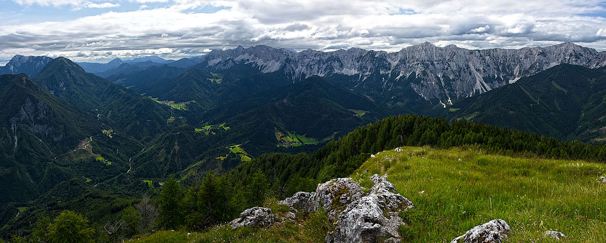
Košuta range from the south
Kosutica / Loibler Baba, 1969 m
The beautiful Kosutica in...
Kosutica is a nice, self-standing peak, which is standing north of the main ridge, paralelly to Veliki vrh. Between the two summits there is Hajnževo sedlo (saddle), which is easilly reachable from both, Slovenian and Austrian side. The summit is popular in dry seasons, in times of tour skiing usually only Hajnževo sedlo is reached, doing the summit with skis is a steep, demanding tour.
Routes overview:
West ridge from Ljubelj pass, 1368 m. On some places steep, but not too difficult marked path. 2 h.
From the road below Sta. Ana, over Korošica. On some places steep, but not difficult marked path. 3 h.
From Hajnž farm, 960 m. On some places steep, but not difficult marked path. 3 h.
From Hajnž saddle (between Košutica and Veliki vrh), 1675 m. Medium difficult, steep, on a few places secured with steel ropes.
Veliki vrh is the highest major mountain in Košuta from the west. It is nicely seen from the south portal of Ljubelj tunnel. Towards the north it is steep and rocky, while towards the south grassy slopes are just not too steep, so they offer one of the best ski tours in Karawanks.
Next towards the east stands a non-important Kofce gora, 1907 m. It is just an elevation in the ridge, but as a home-summit of the Kofce hut it is often ascended. Also in winter skiing is possible from its summit.
Routes overview - Veliki vrh:
From Kofce hut, 1505 m. Easy, on few places steep, marked path. 1 h 30 min.
From Hajnž saddle, 1675 m. Medium hard, steep ferratta, on a few places secured with steel ropes. 1 h 15 min.
Routes overview: Kofce gora:
From Kofce hut, 1505 m. Easy, on few places steep, marked path. 1 h 15 min.
Kladivo / Hajnžturm is a strong mountain with a nice north face, hosting some harder climbs. Over the summit the marked ridge path goes, so it is often ascended when traversing the whole ridge. The summit can be recognised by a distinct rocky tower, rising from the northern slopes.
Routes overview:
From Pungrat alpine meadow, cca 1450 m and oves Škrbina saddle, 1869 m. Steep, marked path. 2 h.
From Škrbina Gasthaus (Male), 1035 m, over Škrbina saddle, 1869 m. Steep, medium hard. 3 h. When visiting Škrbina notch last time (2019), I saw no path ascending up from the northern side!
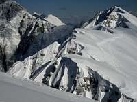
Tegoška gora, 2026 m
On Tegoška gora
From Tegoška gora
Tegoška gora is the next high elevation east of Škrbina saddle. It's a typical Košuta mountain, rocky towards the north, grassy towards the south. Along the whole ridge a summer trail goes. Tegoška gora also offers a few nice ski tours down to the Tegoška alpine meadow.
Routes overview:
From the Pungrat alpine meadow, cca 1450 m, and over the Škrbina notch, 1869 m. Steep, marked path. 2 h.
From the Škrbina Gasthaus (Male), 1035 m, over the Škrbina saddle, 1869 m. Steep, medium hard. 3 h. When visiting Škrbina notch last time (2005), I saw no path ascending up from the northern side - it comes up more towards the east!
Tegoška gora W summit, 2025 m, ski tour. From the Pungrat meadow you continue by the mountain road to the Tegoška planina (meadow) and there turn left. The summit is in the N-NW direction.
Tegoška gora E summit (Visoki vrh / Hohe Spitze), 2044 m, ski tour. From the Pungrat meadow you continue by the mountain road to the Tegoška planina (meadow) and there turn left, towards the north. You gain the ridge between the W and E summit and follow it to the right (steep, ice pick, crampons!). Skiing directly down from the E summit is also quite steep, the tour is graded AD-.
Going from the west, after Tegoška gora, the ridge goes over a few almost equally high elevations, before culminating on the highest point, Košutnikov Turn. The first elevation is Užnik, 2079 m, then the double-summit Macesje / Laerchenberg comes, 2124 m, the last elevation is Ostrv, 2104 m. From the north, the walls below these summits (and the two summits temself) are called Breitwand and Mittelwand. Macesje is a double-headed ridge mountain, quite steep and rocky also on the southern side. Its northern walls (and the wall of Ostrv) host many harder climbs, the ridge path is on many places secured with ropes and is a true ferrata - medium hard and a bit exposed.
Routes overview:
From Dolga njiva, 1402 m. Steep, diffivult path - on top a medium hard ferrata. 3 h.
From Koschutahaus, 1280 m over the notch, W of Košutnikov Turn. Steep, difficult path, then a medium hard ferrata, secured with steel ropes. 3 h.
From the W of Užnik summit marks show down on the northern side. This is a descent (and ascent of course too) option, which brings us down to Cjajnik notch, from which we can descend through the eastern Cjajnik ravine (50 deg. in snow, otherwise very crumbly, unpleasant, a few chains as anchors) down. Difficult, no path!
Cjajnik / Laerchenturm, 1967 m
Cjajnik
Cjajnik / Laerchenturm is a special rocky tower. Standing north of the main Košuta range, it is rocky and wild on all sides and offers no easy ascent. Because just below it the Koschutahaus is standing, it is a very popular climbing polygon.
Routes overview:
The old climbing ascent: (II+), from Koschutahaus.
On September 21st, 2006, a new ferrata on Cjajnik was opened. It is difficult, requiring a complete ferrata set and quite some power in hands. Rated in Austrian system: C/D. My comment would be - it's a pity that one of the last summits in Karavanke is now spoiled with a ferrata.
Kosutnikov Turn / Koschutnikturm, 2132 m
Kosutnikov turn from the east
Košutnikov Turn is the highest summit in Košuta. It can be nicely seen from all sides, but from closer positions on the ridge it appears as a mighty rocky tower. The summit is often ascended from both sides, in the northern face it has some very nice hard climbs.
Routes overview:
From Dolga njiva, 1402 m. Steep, medium hard path. 2 h 30 min (two options, the eastern and western one).
From Koschutahaus, 1280 m through the west ravine. Steep, medium hard ferratta (easy climb). 2 h 30 min.
From Koschutahaus, 1280 m through the east ravine. Steep, medium hard ferratta. 3 h.
Tolsta Kosuta / Dicke Koschuta, 2059 m
On the E ridge
Rock towers in the E face
Tolsta Košuta / Dicke Koschuta is the last high elevation of Košuta, standing on the very east of the long range. Still with a steep rocky face towards the north and with grassy slopes towards the south. Ascent from the south (and by the eastern ridge) is not difficult, as a ski tour very good conditions are required, as the summit slopes are steep.
Routes overview:
From Dolga Njiva, 1402 m over the SE ridge. Steep, medium hard path (T2/T3). 2 h. From Dolga Njiva meadow you continue eastwards to the upper meadows. The shepherds path goes all the time by a (mostly dry) creek bed. When we reach just below the main ridge, we turn left, on the slopes of Tolsta Košuta. Soon we reach the place, where the marked path goes across the east ridge, into the eroded eastern slope (called "Meli"). But we continue up by the east ridge, or just left below it. It is forth going right on the very edge to have a look on interesting towers of the eastern slope. Some 150 m below the summit the path (it is not marked) gets steeper. On a few places a safe step and some care is needed (difficulty perhaps T3). Then we get out on the summit grasses and soon reach the top.
From Gasthaus Terkl, 849 m over Na potoku saddle (Patoksattel), 1411 m and Meli to the SE ridge and to the top. Difficult, demanding orientation! 4 h.
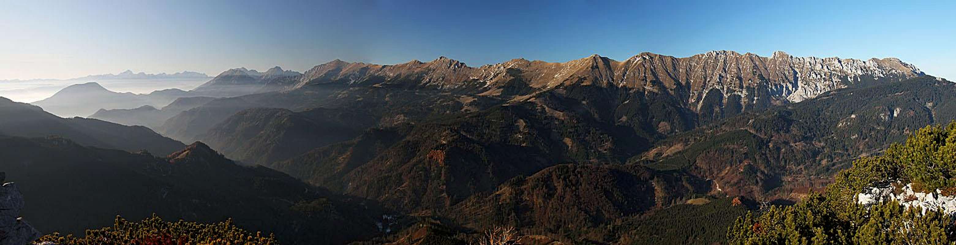
Kališnikovo poldne
Košuta from below Kališnikovo poldne
The common feeling is, that with Tolsta Košuta this long ridge ends on the east. But a closer look shows you, that the main crest indeed lowers much, but continues in the same direction. The mountains which follow are not much important in a mountaineering sense, but to those who strive to explore more remote corners they can still be a nice goal. And the hike from Šajda saddle, where Košuta really ends on the east, over this ridge is a nice half day tour - depending how far you go. The ridge from Tolsta Košuta towards the E-NE is forrested, but the summits are rocky towers, still offering some nice views around.
I came there from Šajda saddle one late afternoon. Reaching below the highest summit, Kališnikovo poldne, I could not find a route on top of those rocks. The marked path is steep and narrow, occasionally exposed, but overall not difficult. But I saw nowhere a sign of an ascent route towards the right. I tried on one place, following a tiny beaten path, but that one ended soon. Having not enough time to explore, I returned very disappointed. So, I hope will be able to describe these summits more in detail some time in the future.
Otherwise the marked path starts gently on Šajda saddle, after some 20 minutes it reaches another saddle, Maležnikovo sedlo, where a nice small church stands. Then it continues by the ridge until below Režovnikovo poldne ('poldne' means 'noon' - these mountains are a sun clock for farms on the north), where the marked path branches and goes by the NW slopes of this hill. Red dots however also lead by its N ridge on top. When the marked path reaches the main ridge again (W of Režovnikovo poldne), there is a crossroads. From the left a marked path arrives up from Francl inn in Korte valley. The continuation goes towards the west. At first by the ridge, but then soon on its steep southern slopes. Below Kališnikovo poldne these are rocky, very picturesque, and because we are now moving already above the valley of Korte, we enjoy nice views towards the south, on Kamnik and Savinja Alps. In several small ups and downs the narrow path crosses the slopes, finally reaching the western ridge of Kališnikovo poldne. There it turns down towards Potok saddle, from which we can either continue towards the west or descend northwards in the valley.
One of main connections between Austria and Slovenia over Karavanke mountains is the road over Ljubelj pass (Loiblpass). This road is the fastest connection between Ljubljana and Klagenfurt.
On the southern side of Ljubelj pass a small town Tržič lies. Here from the main road a side road branches into the valley of Tržiška Bistrica creek. Along this small river a road goes along the whole southern side of Koschuta. On some places from this road side forrest roads go up to the high alpine meadows. Many of them can be done by car and they are of course also very appropriate for mountain biking. Thus we can reach the altitude up to 1300 m. All these roads are free of charge.
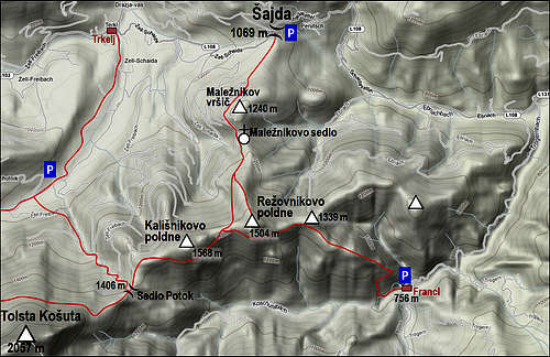
On the northern side the towns of Ferlach (Borovlje) and Eisenkappel (Železna Kapla) are also connected by a road, which approaches Koschuta. From this road towards the south many side roads go up along deep creeks, thus reaching high lying farm houses. Because of many side valleys and roads in them, here is an overview map, showing roughly the situation.
You can see a detailed map on: http://www.austrianmap.at/. That's in German, but as of classical maps, you can refer to:
Karavanke, Central part and Grintovci, 1:50000. Planinska zveza Slovenije.
For ski tours refer to:
Manfred Korbaj: 1. Kaerntner Schitourenfuehrer. H. Weishaupt Verlag. Graz. 1992 (In German language).
M. Črnivec, C. Praček: Turni smuki. Planinska zveza Slovenije, 1984 (In Slovenian language).
Traversing the Whole Kosuta Range
If you come with bus or car on Ljubelj pass, you will need someone to pick you up next day in the valley of Tržiška Bistrica (below Dolga njiva, preferably). You climb first Košutica and descend to Hajnž saddle, ascend by ferratta Veliki vrh and hike comfortably to Kladivo. The descent to Škrbina is a bit harder. Below, you can sleep in the huts of Pungart alpine meadow (have sleeping bag with you). The second day you ascend Škrbina saddle again and continue by the main ridge over Tegoška gora and Macesje towards the east. This part of ridge is harder and requires some carefulness and easy climbing. After you climb the highest point, Košutnikov turn, you may descend down, but if you wish to continue towards the east, a narrow ridge without a path is awaiting for you. This part is a real climbing route, with some places of UIAA II. degree, predominantly I. degree. From Tolsta Košuta you descend to Dolga Njiva meadow. The traversing can best be done with the support of two cars (one waiting below Dolga njiva, the other one on Ljubelj pass). The route is equally attractive in the opposite direction.
Harder Climbs in Kosuta
In Kladivo (Hajnzturm) north face there are nice routes up to degree V.
In Tegoška gora there are two regions, Mittelwand and Breitwand, with routes up to degree VI.
In Cjajnik there are many popular routes up do degree VI.
In Ostrv (close west of Košutnikov turn) there are some routes up to degree VI-.
In Kosutnikov turn there are many popular routes up to degree V.
Ski tours list
Like a giant wave is Kosuta
From Hanjž saddle on both directions (towards the NE or SW). Medium hard.
From Veliki vrh to Kofce hut and further down into the main valley. Medium hard, classical tour, highly recommendable!
From Kofce gora and Kladivo towards the south. Medium hard, steep ski tour.
From Škrbina towards the south. Easy tour.
From Tolsta Košuta to Dolga njiva. Difficult, on the top part steep ski tour.
Ski tour from the highest summit, Košutnikov turn, is possible, but is considered an alpinictic descent. The upper slopes are very steep, also the Eastern ravine is steep and dangerous.
Red Tape
No limitations. The route from Sela (Zell) towards Koschutahaus must be paid.
Koschuta can be climbed in all seasons. For hiking and climbing best months are July to October. For tour skiing best months are January to May (depending on snow). Weather: see here.
Camping
Dom na Kofcah, 1505 m. Opened from April to October, 28 beds. Tel.: 050/ 625 653.
Koschutahaus, 1279 m. Opened from June 1st to October 31st, 60+10 beds.
Children refers to the set of objects that logically fall under a given object. For example, the
Aconcagua mountain page is a child of the 'Aconcagua Group' and the 'Seven Summits.' The
Aconcagua mountain itself has many routes, photos, and trip reports as children.
Parents refers to a larger category under which an object falls. For example, theAconcagua mountain page has the 'Aconcagua Group' and the 'Seven Summits' asparents and is a parent itself to many routes, photos, and Trip Reports.

 18439 Hits
 88.61% Score
 27 Votes


 haubi - in Tihotapska route
 Veliki vrh
 JFS - Veliki vrh
 From the S
 On Veliki vrh
 On Tegoška gora
 From Tegoška gora
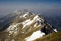 Petr Drápalík - Košuta range


 Košuta from below Kališnikovo poldne


 Zell/Sela
 Petr Drápalík - A mossy path


 JFS - Winter on Veli vrh
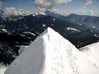 haubi - winter ascent


