
|
|
Mountain/Rock |
|---|---|
|
|
41.78000°N / 20.54000°E |
|
|
9068 ft / 2764 m |
|
|
Overview
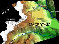
Maja e Korabit (albanian) or Golem Korab (macedonian) both refer to the same, 2763m/9068f high mountain right on the border between Albania and Macedonia. It is a highest mountain for both countries, one of two summits in Europe being national highpoint for more then one country, and 12th highest national point in Europe. Name "Korab" is of Slav origin, it was considered to be a God of sea by various Slavic tribes, before they have switched to christianity. Korab may be considered an off the beaten track mountain resort, at least by the European standards.
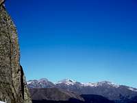
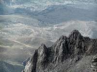
Location: Mt. Korab ispanning in a slightly NE to SW orientation, from Golema Korabska vrata pass (2062m) on the nordern end, to the Mali e Grames, just after the Ciganski premin pass on the southern end. A rugged main ridge as well as the summit itself do offer both great and extensive views in all directions (please, see the panoramas further down the page). Beacuse of the bordercrossing policy between two countries and the logistical issues, ascending from the one side and descending down the other side of the mountain currently is not feasible, some day in the future this may change, though.
Getting There - part one
Closest intl airports are those of Tirana (Albanian capital) and Skopje ( capital of FYRO Macedonia). To someones disbelief it may be, but geographical distance from Korab to any of those 2 airports is almost the same, mile or km more or less. Skopje has decent train connections with rest of Europe hence some major routes to Thessalon

iki/Greece pass through the Macedonian capital . Please, reffer to German railways connection query. By car: for the sake of convinience and accesibility by road, we`ll stick with the Macedonian route. and our main goal is to reach the trailhead at Stezimir watchtower on the Macedonian side of the mountain. In order to achieve that, we`ll going to hit the Skopje -Tetovo motorway (around 40km of that one). From Tetovo - no need to go into the town - another 30 km of surfaced roadleading SW takes us till town Gostivar where we catch with the Gostivar-Debar road. Another 20 km or so up the Gostivar-Debar road takes us to Mavrovi Anovi, Mavrovi Anovi is rather small town a common point for short trip break with several food shops, restaurants, and one Hotel. This is where we are going to refill our supplies with all the neccessary food and liquid. Only in case we didnt mind to carry those all the way from Skopje, that is.
Getting there - continued
From Mavrovi Anovi , we`ll drive further till village Trnovo, 8km or so from Mavrovi Anovi. At Trnovo, we`ll turn right and off the main Gostivar-Debar road, wave goodbye to the asphalt and say hello to the unpaved carriage road and progress southwestbound toward the village of Nicpur. From Trnovo via Nicpur it takes around 19 km of solid macadam road till sharp leftbound curve beneath Stezimir (watchtower, remember?). After living your car behind, 1 mile of footwork uphill theaforementioned curve takes you to the Strezimir watchtower. This is where visitors are supposed to leave their vehicles. Now you are inside the Macedonian-Albanian boundary area (special permit required, please refer to the Red tape section, further down the site). After living your car behind, 1 mile of footwork uphill the aforementioned curve and a bit further takes you to the Strezimir watchtower. Final ascend is more or less straight forward, another portion of the carriage road takes us uphill next to the creek, till the old now abbandoned military watchtower - last place to refill you potable water supply, then gradually catches with the main Korab ridge due north. 4 to 5 hours of nontechnical hike up takes us to the main summit
Getting there from the west (Albania)
The city closest to Korab mountain is Peshkopi. It's a five hours drive from Tirana. Daily mini-busses and busses are connecting the town with the capital. Do not hesitate to approach to Peshkopi from Macedonia - the roads in Albania are much bumpier as in Macedonia. The border-crossing close to Debar is some 45 minutes away from Peshkopi.
In Peshkopi, you easily can find a place to sleep. There aren't any hotels closer to Korab on this side of the mountain. Trained mountaineers might be able to make the trip up to Korab from Peshkopi and back in one day, even though the streets are bad. If you plan do to so, you should leave Peshkopi before 6 am.
From Peshkopia, you can approach Korab on the road till the village of Radomirë on 1250 Metres (the area there is called Kala e Dodës). It's a trip of about 40 kilometres - you can do it with a normal car if you do not take care about your dampers. All-wheel drive and high ground clearance is adviced. The journey from Peshkopi to Radomirë takes about 1.5 to two hours.
Two kilometres after Peshkopi, you leave the sealed road (the raod's forking, take the route to the right). Five kilometres further on, you have to turn right (close to a school) in direction of the village of Kastrioti. Follow this road for another 30 kilometres. It will lead you into a gorge and with several bends up the hill on the other side. There, before you enter the village of Cereni, take a sharp turn to the right. Follow the road into the valley to Radomirë (two kilometres).
There are mini-busses on this road connecting Peshkopi with the villages and Kukës. With some luck, you can get to Cereni on public transport. But this takes even more time.
You might be able to find BASIC private accomodation at Radomirë. Try looking for help at the local store (ushqimore). Some people in the village used to work in England. Do not rely on finding a guide in Radomirë.
Panorama from the summit - orientation NW-SW
Panorama from the summit - orientation NE-SE
Camping
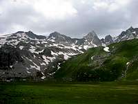
There are no mountain huts on mt. Korab. If you plan to spend more than 1 day wandering around, bring the tent and sleeping bag(s). Spare option is to base yourself inside Mavrovo National Park which is not too far away.
Red Tape (update as of spring 2011)
Once you reach Stezimir you are inside the Macedonian-Albanian boundary area and to do that was required from the FYROM Ministry of internal affairs.
As of the latest, however
There are no red tape restrictions on Korab.
There is no special permit required.
It is enough to report to the Strezimir police station
on your way up, if you find anybody on duty.
Most of the border posts on the mountain are abandoned
and there are few if any police patrols.
(updated thanks to SP member martintaleski
Othervise, there are no summit fees, nor a parking pass or fees, hovewer visitors are supposed to leave their vehicles at the curve on the main macadam road beneath Stezimir watchtower, as described above.
Mountain conditions, weather
As so many mountains in this part of Europe, high hiking season is July/ August. However, given the overall climate circumstances - Macedonia is characterised by cold, damp winters and dry almost subtropical summers when temperature reaches 40 degrees Celsius - June and early September will be fine..
Please, noteas well that there are many springs, creeks and plains on the Albanian side of Korab Mountain.
Crossing them can get hard when rain starts. It's recommended to climb only at dry weather.
For weather conditions, please lurk at AccuWeather forecast for Macedonia
External Links
- Macedonian Mountain Sports Federation website
Email: shara@mt.net.mk - Mountaineering Club "Korab" website
Limited info in English.
However, if you plan to climb Korab from FYROM side, we would highly reccommend to contact them for any up-to-date info. - link for "Macedonia Yesterday and Today", book by Jovan Pavlovski & Mishel Pavlovski
Nice and informative book, not strictly hiking related, though.
Couldnt find ISBN for it. - Offical website of mountain club "Korab" - Skopje, Macedonia
At the site there is detailed reports and photos, and announcement of Golem Korab's climb since year 2000 when mountain club "Korab" took over the organization of this biggest mountaineering event in Macedonia.
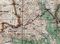
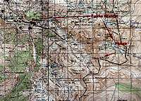
Topographic maps & more images
 |
 |
 |
 |
toc - Feb 26, 2004 2:16 pm - Hasn't voted
Untitled CommentHello.
Highest points are ranked on
country-by-country basis.
So, MeK/GK ranks 12th on the Europe's Continent
Height Rank, just squeezed between Triglav of Slovenia and Djeravica of Serbia and Montenegro,
with Mont Blanc/Monte Bianco topping the rankings,
Dufourspitze of Switzerland beeing #4,
Coma Pedrosa of Andorra at #8 and so on...
down to the Rock of Gibraltar of Gibraltar at #41
and all the way bottomdown to the Vatican Hill of the Vatican City at #51.
Needless to say, no coincidence whatsoever with
the highest peak or highest mountain rankings.
It was just a bit of statistics, redundant perhaps.
The photo enclosed shows an except of the full Continent height ranking list for Europe.
Countrys are listed
in the alphabetical order, columns starting from L to R
represent Country name/Country highest point/height Feet/ height meter/Lat /Long/ Continent Height Rank/ World Height Rank
best regards
toc
Dan Bailey - Mar 8, 2004 7:32 am - Hasn't voted
Untitled CommentThanks for clearing that up toc! So where does the Netherlands rank?!
cheers
Dan
toc - Mar 9, 2004 4:21 pm - Hasn't voted
Untitled CommentVaalserberg of Holland (1053feet/321m)
ranks #35 in Europe,
between Monte Titano of San Marino at #36
and Slaettaratindur of Faroe Islands at #34.
(Sadly, never climbed any of those myself)
best regards,
toc
kamil - Jun 26, 2005 12:44 pm - Voted 10/10
Untitled CommentHi!
Great to hear you made it! Got any idea how far can you get by normal car from the side of Kukes-Bicaj towards Radomir without breaking my suspension? I may try to approach from there this summer. Of course a repport would follow.
And do you know if there's any redtape problem crossing the Kosovo-Albania border by car?
cheers!
Kamil
albinfo - Jun 26, 2005 7:03 pm - Voted 10/10
Untitled CommentWe made it to Radomir in a normal car (first an Audi. When the fan belt broke, with a smaller one). The people in the village who have cars do have normal ones as Mercedes. This means, that the wholes in the road aren't as bad that you can't pass, but your car won't like the road.
Entering Albania by car should be possible without problem. But you have to pay an insurance tax for the car for each day you stay in the country. If you'll need a visa depends to your nationality. In the majority of cases, you only have to pay € 10 when crossing the border.
tjalfi - Jun 29, 2005 4:56 am - Hasn't voted
Untitled CommentHow safe is it to pitch the tent on the Albanian side of Korab? What about thugs, gun smugglers etc.?
albinfo - Jun 29, 2005 4:45 pm - Voted 10/10
Untitled CommentYou'll only meet some shepherds. Don't believe all the stories about everybody who goes to Albania will be killed. Watch out a little bit, do not act incautiously and you shouldn't have any problem.
I recommend to make contact with the shepherds, ask them if you can put up the tent close by. I haven't slept there, but everybody we met up there was very friendly. Several invited us to stay at their place.
kamil - Aug 21, 2005 3:16 pm - Voted 10/10
Untitled CommentAlbinfo, thanks a lot, you helped us a great deal. We made it late July, got to Radomire from the north. The report will follow.
cheers!
toc - Jan 20, 2004 6:03 pm - Hasn't voted
Untitled Commenthttp://www.mt.net.mk/e/info/vremenskaprognoza/index.asp
Dan Bailey - Feb 25, 2004 11:36 am - Hasn't voted
Untitled CommentHi
Just a quick question: You say it's the 12th highest point in Europe...what do you mean?!
Cheers
Dan
toc - Feb 26, 2004 2:16 pm - Hasn't voted
Untitled CommentHello.
Highest points are ranked on
country-by-country basis.
So, MeK/GK ranks 12th on the Europe's Continent
Height Rank, just squeezed between Triglav of Slovenia and Djeravica of Serbia and Montenegro,
with Mont Blanc/Monte Bianco topping the rankings,
Dufourspitze of Switzerland beeing #4,
Coma Pedrosa of Andorra at #8 and so on...
down to the Rock of Gibraltar of Gibraltar at #41
and all the way bottomdown to the Vatican Hill of the Vatican City at #51.
Needless to say, no coincidence whatsoever with
the highest peak or highest mountain rankings.
It was just a bit of statistics, redundant perhaps.
The photo enclosed shows an except of the full Continent height ranking list for Europe.
Countrys are listed
in the alphabetical order, columns starting from L to R
represent Country name/Country highest point/height Feet/ height meter/Lat /Long/ Continent Height Rank/ World Height Rank
best regards
toc
Dan Bailey - Mar 8, 2004 7:32 am - Hasn't voted
Untitled CommentThanks for clearing that up toc! So where does the Netherlands rank?!
cheers
Dan
toc - Mar 9, 2004 4:21 pm - Hasn't voted
Untitled CommentVaalserberg of Holland (1053feet/321m)
ranks #35 in Europe,
between Monte Titano of San Marino at #36
and Slaettaratindur of Faroe Islands at #34.
(Sadly, never climbed any of those myself)
best regards,
toc
boge - Jun 3, 2005 11:31 am - Hasn't voted
Untitled CommentPermits are issued bu the Ministry of internal affairs.
boge - Jun 3, 2005 11:32 am - Hasn't voted
Untitled CommentPermits are issued by the Ministry of internal affairs.
boge - Jun 3, 2005 11:42 am - Hasn't voted
Untitled CommentBest way to climb Golem Korab is The annual international climb that tooks part every september, this year at 04.09.2005. The climb is organized by mountain club "Korab" from Skopje. They are getting a collective permit for all the participants.
albinfo - Jun 25, 2005 7:58 pm - Voted 10/10
Untitled CommentThe city close to Korab mountain is Peshkopi. It's a five hours drive from Tirana. Daily mini-busses and busses are connecting the town with the capital. Do not hesitate to approach to Peshkopi from Macedonia - the roads in Albania are much bumpier as in Macedonia. The border-crossing close to Debar is some 45 minutes away from Peshkopi.
In Peshkopi, you easily can find a place to sleep. There aren't any hotels closer to Korab on this side of the mountain. Trained mountaineers might be able to make the trip up to Korab from Peshkopi and back in one day, even though the streets are bad. If you plan do to so, you should leave Peshkopi before 6 am.
From Peshkopia, you can approach Korab on the road till the village of Radomirë on 1250 Metres (the rea there is caled Kala e Dodës). It's a trip of about 40 kilometres - you can do it with a normal car if you do not take care about your dampers. All-wheel drive and high ground clearance is adviced. The journey from Peshkopi to Radomirë takes about 1.5 to two hours.
Two kilometres after Peshkopi, you leave the sealed road (the raod's forking, take the route to the right). Five kilometres further on, you have to turn right (close to a school) in direction of the village of Kastrioti. Follow this road for another 30 kilometres. It will lead you into a gorge and with several bends up the hill on the other side. There, before you enter the village of Cereni, take a sharp turn to the right. Follow the road into the valley to Radomirë (two kilometres).
There are mini-busses on this road connecting Peshkopi with the villages and Kukës. With some luck, you can get to Cereni on public transport. But this takes even more time.
You might be able to find BASIC private accomodation at Radomirë. Try looking for help at the local store (ushqimore). Some people in the village used to work in England. Do not rely on finding a guide in Radomirë.
albinfo - Jun 26, 2005 10:37 am - Voted 10/10
Untitled CommentNo permit is required when climbing the mountain from the Albanian side. But be aware that you're in the boundary area - do not do anything that can provoke the boundary patrols of either side of the boundary.
albinfo - Jun 26, 2005 10:40 am - Voted 10/10
Untitled CommentThere are reports about mines and other weapons in the Kosovar boundary area that starts only some kilometres north of Korab mountain. It's better to stay on the paths when hiking in the area north of Fusha Korabit.
albinfo - Jun 26, 2005 10:43 am - Voted 10/10
Untitled CommentThere are many springs, creeks and plains on the Albanian side of Korab Mountain. Crossing them can get hard when rain starts. It's recommended to climb only at dry weather.