
-
 53614 Hits
-
 90.13% Score
-
 31 Votes
|
|
Mountain/Rock |
|---|---|
|
|
45.08900°N / 109.587°W |
|
|
Hiking, Mountaineering, Scrambling, Skiing |
|
|
Spring, Summer, Fall, Winter |
|
|
12551 ft / 3826 m |
|
|
Overview
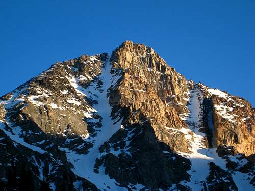
This aptly named peak is the fifth highest peak in Montana and certainly one of the best objectives in the state. Its name comes from the narrow but prominent snow and ice-filled couloir (50° sustained) that extends down from near the summit for over 2000 feet into the West Fork Rock Creek valley on the Northside of the mountain. Whitetail has the stereotypical mountain form, and from a distance, especially viewed from the north, can appear quite intimidating. The easiest route up the mountain is no more than a hike with a short amount of Class 3 scrambling. Due to its proximity to the Sundance Pass trail, Whitetail attracts a fair share of visitors and is a popular summer destination for local weekend climbers.
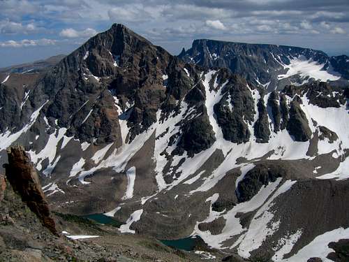
From the summit of Whitetail, one can get a great sense of the immense power that glaciation can have. The huge U-shaped valleys and big cliffs that were carved out of the massive Beartooth plateau have shaped the range to the dramatic and beautiful mountains we see today. Permanent snowfields still cling to the base of Castle Mountain at the head of West Rock Creek valley three miles to the West and if one were to look closely, some large Bergschrunds can still be found. Filling the valley floor below are the rock-strewn glacial moraines which make the approach for nearby Castle Mountain so formidable. Three miles to the south across another U-shaped valley one has a fantastic view of Beartooth Mountain itself, and just to the southwest extends a fantastic ridgeline that includes Medicine and Sky Pilot Mountains.
There are many potential routes on Whitetail Peak however two of them are by far the most commonly done. The Whitetail Couloir and Northeast Ridge are the main routes however one can conceivably climb directly up the south face or even climb one of the features to the west of the couloir on the north face. The couloir is also an excellent ski descent that avid skiers will try their skills on. With all this, Whitetail Peak is probably one of the most sought after and well-known peaks in Montana.
 Whitetail Peak and its namesake couloir Whitetail Peak and its namesake couloir |
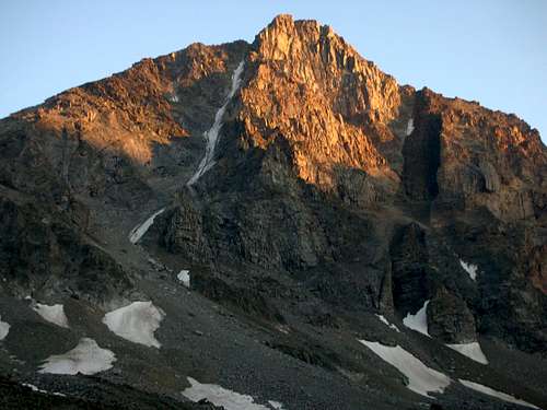 Whitetail at Sunset Whitetail at Sunset |
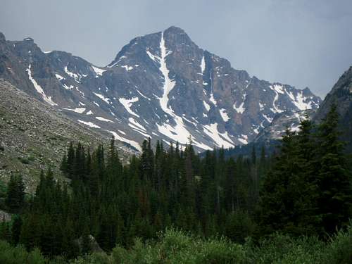
 The NW face of Whitetail The NW face of Whitetail |
Getting There
Trailheads
West Fork Rock Creek Trailhead
This is one of the more popular trailheads in the Beartooth Mountains and offers fantastic scenery. From the center of Red Lodge at the MT 308 and US 212 junction, head west 0.3 miles on US 212 and turn right onto the West Fork Road with signs for the Red Lodge ski area and measure distances from this turnoff. The road immediately comes to a Y, stay left and head up the paved road passing the Palisades Campground Road (gravel) on the right after 1.1 miles. Continue and enter the Custer National Forest after 2.8 miles and turn left to stay on the West Fork Road at 2.9 miles. Taking a right at this turnoff takes you to the ski area. Pass the winter closure gate at 5.2 miles, the Basin Lake Campground at 7.2 miles and the road turns to gravel at 7.4 miles. At mile 10.5, pass the Cascade Campground and reach the trailhead at mile 13 with an elevation of 7,890 feet. Here there is room for about 40 cars and 7 horse trailers and a pit toilet is available.
Lake Fork Rock Creek Trailhead
From the Montana State 308 and US Highway 212 junction in Red Lodge, go 10.8 miles west on US 212 towards Beartooth Pass and turn right onto the Lake Fork Road. Go 1.8 miles on this paved road to its end at the trailhead with ample parking. The elevation at this trailhead is 7200 feet.
Approaches
West Fork Appeoach
From the West Fork Rock Creek trailhead, start up the trail and take an immediate left with a sign for Quinnebaugh Meadows and Sundance Lake. Follow this trail for two miles through a burn area and reach the small Sentinel Falls at 8,400 feet just past a couple switchbacks. Continue up the more forested trail another 2.2 miles to Quinnebaugh Meadow and the junction with the Lake Mary Trail. The meadow offers fantastic camping and the first views of Whitetail Peak. Continue straight and cross the stream draining Lake Mary on a series of small logs or rocks and reach the first culvert bridge 0.6 mile past the Lake Mary junction at 8,950 feet. At this bridge a short boot path heads up this side drainage towards Senal and Dude Lakes. From here, continue up the flat and well groomed trail for 1.2 miles to a second culvert bridge that crosses Kookoo creek which drains Kookoo Lake. Beyond this point the trail steepens for the next 1.6 miles and climbs 500 feet over a series of switchbacks to a very nice footbridge crossing the West Fork Rock Creek to its SW side.
From this footbridge, you can either camp right next to it on the small grassy bench or continue up the main valley without crossing the footbridge on the creeks NW side over talus and grass for 0.4 mile to Shadow Lake. Excellent camping can also be found at Shadow Lake but don't expect sun in the afternoon...it's called Shadow Lake for a reason.
RT Distance:From trailhead to camp at Quinnebaugh Meadow – 8.4 milesFrom trailhead to Sundance Pass – 21.2 milesFrom trailhead to Shadow Lake – 16 milesRT Elevation Gain:From trailhead to camp at Quinnebaugh Meadow – 1000 feetFrom trailhead to Sundance Pass – 3,050 feetFrom trailhead to Shadow Lake – 1,610 feet
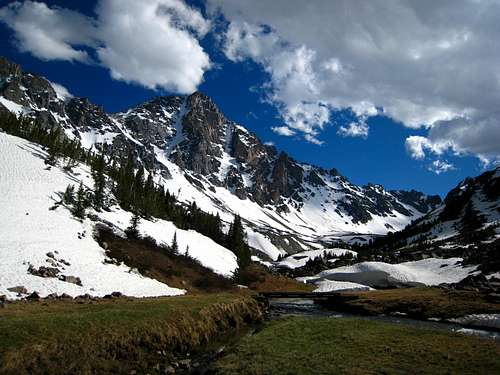
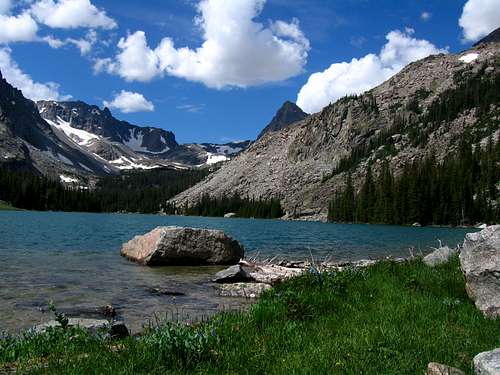
 Whitetail Peak from Quinnebaugh Meadows Whitetail Peak from Quinnebaugh Meadows |
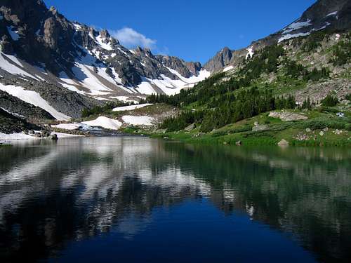 Shadow Lake Shadow Lake |
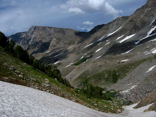 Looking down the valley Looking down the valley |
Lake Fork Approach
Approaching from the Lake Fork isn't as scenic but is commonly done for Whitetail Peak. This approach is only feasible for the standard NE ridge route though as the Whitetail Couloir route doesn't start from Sundance Pass, where both approaches meet but instead starts just above Shadow Lake. However, the Lake Fork Trail is much more forested and views are harder to come by. From the Lake Fork Trailhead, follow the trail along the south side of the creek for 4.7 miles to the junction with the Lost Lake trail. This spur trail leads 0.2 miles to Lost Lake with good camping, but poor fishing. Lost Lake sees a lot of day hikers so don’t expect much solitude here. Continue past the junction 0.3 miles to the nice foot bridge crossing the Lake Fork at 8440 feet.
Once on the north side of the Lake Fork, continue up the trail a short ways to a signed junction just before the trail begins traversing steeply above the Lake Fork. Heading down and to the left at this junction is a small side trail leading down to Keyser Brown Lake. Great camping and fishing is found here and an assortment of boot paths and game trails leads further to the turquoise colored First and Second Rock Lakes. For the adventurous hikers, you can continue to the head of the Lake Fork drainage passing below the north face of Beartooth Mountain, and reaching Sky Pilot Lake after a long day of bushwhacking and talus hiking. The south ridge of Sky Pilot Mountain can be reached via Sky Pilot Lake.
Although not thoroughly described on this page, one can also climb the south face of Whitetail Peak starting from a point about a mile past the west end of Second Rock Lake. At a 100 foot cascade in the Lake Fork at 9,600 feet in elevation, begin ascending north through the trees passing around a small 10,540 foot knob. Once past this knob, continue directly up the south slopes staying close to the crest of the broad ridge. Views to the east down the Lake Fork are stunning and to the west the daunting east face of Sky Pilot Mountain inspire all outdoor enthusiasts. Note that the ascent up the south side is a steep talus hike with interspersed scrambling on loose rock. Reach the same notch at the top of the Whitetail Couloir and continue the final scramble to the summit.
For the standard NE Ridge route though, continue up the trail as it traverses above the Lake Fork to September Morn Lake, continue a couple more miles to Sundance Pass and take a nice break and enjoy the views before finishing the climb.
RT Distance:From trailhead to September Morn Lake – 15 milesFrom trailhead to Sundance Pass – 20 miles
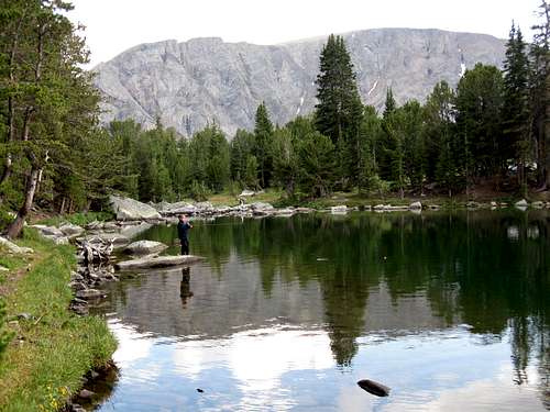 September Morn Lake September Morn Lake |
 Second Rock Lake Second Rock Lake |
Route Options
Northeast Ridge Standard Route - Class 3
Use either the West Fork Rock Creek or the Lake Fork approach and hike to Sundance Pass. Although this is one of the possible summit day hikes in the Beartooth Mountains, it is best to make camp at either Quinnebaugh Meadow or Shadow Lake. From Sundance Pass, hike southwest up the ridge staying to the left (south) side of a narrow section of ridge just above the pass. Beyond this, hike up easy talus to 11,250 where a small rock tower can be seen. Contour to the east of the summit of Mount Lockhart and to the west of the rock tower on flat terrain and descend 100 feet to the 11,570 foot saddle between Lockhart and Whitetail 1.4 miles from Sundance Pass. From this saddle, climb 0.5 mile on steepening talus (Class 2) for 800 feet and reach the top of the north couloir route at 12,400 feet. Cross the small saddle and climb the initial 15 foot wall (Class 3). Scramble west for 150 feet on the northeast ridge to the summit. There are many cairns on this route. Descend the ascent route. This route is a 25 mile round-trip hike from the trailhead so be prepared for a long day.
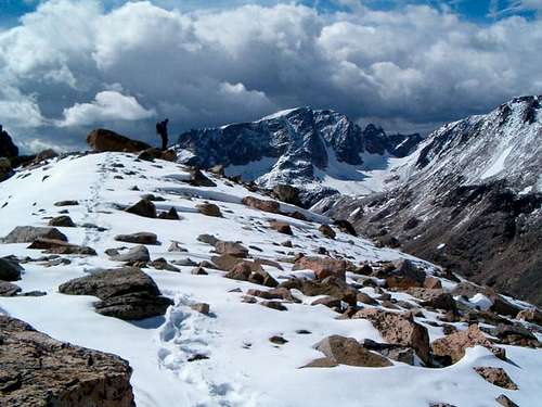 On the NE Ridge route On the NE Ridge route |
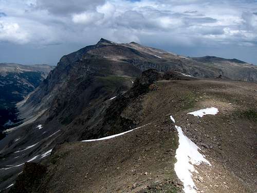 The NE Ridge route from the summit The NE Ridge route from the summit |
Whitetail Couloir - Class 3 and Steep Snow
Use the West Fork Rock Creek approach and set up camp at Shadow Lake. Hike to the southwest end of the lake and cross the stream on talus where the water flows below the rocks. Turn left (south) and hike up talus aiming for the long narrow couloir cutting deep into Whitetail Peak. The talus slope eases at 9,850 and the snow will likely start here, if not sooner. Climb moderate (35-40 degree) snow and enter the couloir proper at 10,800 feet where it curves to the right. Continue up as the slope steepens to 45 degrees at 11,000 feet, then up to 50 degrees at 11,700 feet. There is a nice place to rest to the left edge on rock here. A running belay using rope and pickets is recommended for the final 700 feet. In late season, the upper part becomes icy which could be a problem for unprepared parties. Check the conditions of this couloir before climbing. Reach the top at a 12,400 foot small saddle and climb the initial 15 foot wall out of the saddle (Class 3). Scramble west for 150 feet on the northeast ridge to the summit. Descend the northeast ridge route. This climb takes about 5 hours from camp to the summit.
RT Distance:From Shadow Lake with descent of northeast ridge – 7.1 milesFrom trailhead with descent of northeast ridge – 23.1 milesOne way distance from Shadow Lake – 2.1 miles
RT Elevation Gain:From Shadow Lake with descent of northeast ridge – 3,000 feetFrom trailhead with descent of northeast ridge – 4,700 feet
 Whitetail Couloir Whitetail Couloir |
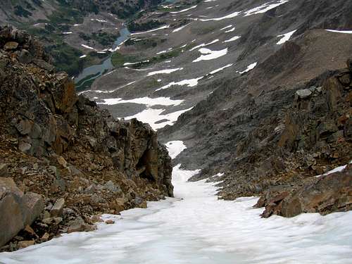 Looking down the couloir from the top Looking down the couloir from the top |
Map
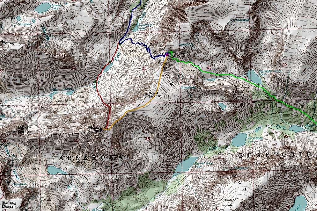
BLUE: West Fork Rock Creek Approach - Class 1
GREEN: Lake Fork Rock Creek Approach - Class 1
ORANGE: Northeast Ridge Route - Class 3
RED: Whitetail Couloir Route - Class 3 and Steep Snow
Green Dots: Camping Spots
Purple Dot: Sundance Pass
Note the south face route isn't drawn but is visible between the "O" and the "K" in Absaroka
Camping/Red Tape
Camping is allowed anywhere within the Absaroka-Beartooth Wilderness. You are "requested" to check in with the Beartooth Ranger Station in Red Lodge or call (406) 446-2103 before camping. You must have a permit to cut live trees for firewood. Most parties choose to climb Whitetail in two days, camping either at the base of Sundance Pass by the foot bridge on the West Fork trail, or at September Morn Lake on the Lake Fork approach. Remember to practice Leave No Trace, and as always in bear country, hang your food well away from camp at night and carry bear spray.
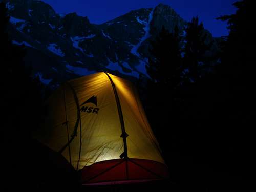 Whitetail Peak camp
When to Climb
Spring: For ascents from April through June, the weather can be very unpredictable and snow can fall during any ordinary storm. Be prepared for cold and windy conditions. Despite this, fantastic weather can be found and offers beautiful alpine scenery. This is the prime time to ski the Whitetail Couloir if this is your goal. People often skin up the valley and climb the couloir while carrying skis then ride down. This line is for expert skiers only and has caused serious injuries to some who have failed on the descent. Gear needed for the climb are mountaineering boots, crampons, three pickets, alpine rope and harness and an ice axe. If you are confident on 50-degree snow some parties do free solo the climb.
Summer: Summer ascents of Whitetail Peak can vary a lot depending on the previous winters' snow-pack. The best time to climb it is July through early September. For the couloir, usually by August much of it is too icy to be climbed simply with crampons, pickets and one ice axe but this doesn't deter some of the most avid climbers from ascending during late summer. Ice climbers who are prepared with ice screws, two axes, steel crampons can make the ascent in August but by the time September rolls around, the couloir begins drying out and it is best avoided altogether.
Fall: From September through December, fall snows begin to accumulate making scrambling more tedious. Windstorms begin making ascents more brutal. The Northeast Ridge route is the best option in the fall due to loose rocks and lack of firm snow in the couloir.
Winter: This peak is somewhat of an expedition-style climb from January through March with harsh weather and very large avalanches common. The route isn't recommended except when the snow-pack is very stable. Add the very long approach, skis may be required.
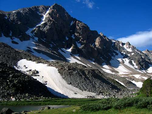 Whitetail Peak in nice summer conditions Whitetail Peak in nice summer conditions |
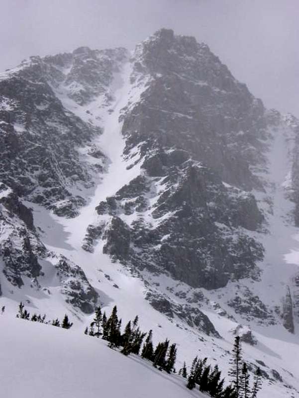 Whitetail Peak in early spring Whitetail Peak in early spring |
External Links
Excellent Whitetail Couloir TR