
-
 27045 Hits
-
 87.26% Score
-
 24 Votes
|
|
Area/Range |
|---|---|
|
|
39.36800°N / 105.605°W |
|
|
12429 ft / 3788 m |
|
|
Kenosha Mountains Overview
 Frozen tarn just below the summit of Peak X. May 10, 2012.
 The Kenosha Mountains are one of three ranges that border the east side of South Park. Sandwiched in between the Platte River Mountains and the Tarryall Mountains, they are contained almost entirely within the confines of the Lost Creek Wilderness. Geographicaly they begin to the northwest at "Platosha", the informaly named pass traversed by the Ben Tyler Trail, and end to the southeast in the vicinity of Wellington Lake. The main summits of the Kenosha Mountains often lack official designations (quotation marks indicate unofficial names) but have been nicknamed by locals or the esteemed Gerry and Jennifer Roach. From northwest to southeast the summits of the Kenosha Mountains are: "Kenosha Peak" (12,100 ft), "X Prime" (12,100ft), "Peak X", a.k.a "Knobby Crest" (highpoint of the range at 12,429 ft), "Peak Y" (12,274 ft), "Peak Z" (12,244 ft), "Zephyr Peak" (12,067 ft), "Eurus Plateau" (a.k.a. Unnamed 11,936), Unnamed 11,731, Windy Peak, Buffalo Peak, and The Castle. This page will focus on the main range crest which consists of a glorious 6.7 mile ridge above timberline running from "Kenosha Peak" to "Zephyr Peak".
 The summits themselves are in the mid to low twelve-thousand foot range, and generally consist of steep aspen draped lower slopes that even out to beveled summit plateaus; with many rock outcrops studding the slopes both below and above timberline. The rocks are not as abundant as in the Tarryall Mountains, being more subtle in their appearences, in contrast to the almost decadent profusion found around Bison Peak and McCurdy Mountain. This is not to say that they lack charm; the rounded knobs, abrupt buttresses, walls, and towers found on several of the Kenoshas stand in proud counterpoint to the terrain found in the Tarryalls. There are even a couple natural "eyeholes" in rocks around several of the summits. Truely the Kenosha Mountains represent the other half of the intimate mountain experience found within the Lost Creek Wilderness.
The appeal of the Kenoshas is closely interwoven with the unique aesthetics of the region. They cannot compete with the glacial grandeur of the Indian Peaks or the colorful volcanics of the San Juans. But they can offer a serene mountain experience in a setting that is different from that found amongst so many of Colorado's mountains. Their extensive aspen groves and knobby rocks are worth a visit. The easy access and lower elevations make them a wonderfull year-round playground. The close proximity of the summits in the section of the main range crest allows for the oportunity of multi-summit excursions... including the possibility of traversing all six summits in this section in one day. Several Route descriptions will detail the possibilities.
One fact of climbing the Kenosha Mountains is bushwhacking. I will cover this in more detail in a later section but all major summits of the Kenosha Range besides "Kenosha Peak" and perhaps "Peak X" (under ideal conditions) require some degree of bushwhacking.
Geologicaly the Kenosha Mountains are composed of granites of the one billion year old Kenosha Batholith (these granites are greyer then the potassium rich rocks of the Pikes Peak Batholith, which incidently, primarily comprise the nearby Tarryalls) which have intruded into the surrounding granites and gneisses of the 1.7 billion year old Idaho Springs formation. They are part of the general folded anticline which hoisted large sections of the Front Range above the plains to the east. Distinctive to the Kenosha Mountains is the presence of the Elkhorn Fault on their western boundary. This marks a reverse fault where the igneous and metamorphic rocks of the Kenosha Mountains overrode the sediments that sit on the floor of South Park. This likely occured as the confining pressure was removed from these long burried sections of rock and they shifted towards the downdropped anticline of South Park.
Peak X and Peak Y from Peak Z, October 2005.
"Kenosha Peak" 12,100 ft. Overview
"Kenosha Peak" marks the north end of a 6.7 mile ridge that is the highlight of the Kenosha Mountain Range. It is a gentle rounded summit having likely been covered by the same ice sheet that ground down the slopes of the nearby Twin Cones. It is a summit for lounging and launching on grand adventures. The view from the summit is well worthwhile. "Kenosh Peak" is easily accessed from the Ben Tyler trail by travelling south up easy slopes to the mellow summit. |  |  |  |
"X Prime Peak" 12,100 ft. Overview
"X Prime" is the infrequently visited northern companion of "Peak X". Although people seldomly set foot on the summit rocks it is a popular summit with the area's bighorn sheep. The northern slopes of "X Prime" rise gently from the range crest but a small outcrop gives the south face some distinction. The summit area is actualy occupied by three rounded rock outcrops with the southernmost being the highest. "X Prime" combines well with "X Peak" besides giving good views of it. This is a place to relax. |  |  |  |  |
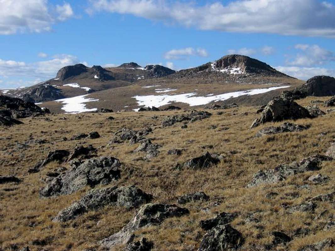
"Peak X" ("Knobby Crest") 12,429 ft. Overview
"Peak X", know perhaps more accurately as "Knobby Crest" is the 12,429 foot tall reclining monarch of the Kenosha Mountains. The highest summit of the Kenosha's "Peak X" leans back above timberline, providing huge shelves of alpine tundra, capped by a gentle sweep of easy slopes to the many knobby rock outcrops on the summit region proper. The summit plateau is well endowed with the tradmark rock outcrops of the region. Ascending all the towers and outcrops is a must for those realy interested in partaking of the Kenosha Mountains ambiance.It is easily accessed from the Long Gulch Trailhead and its summit region provides a worthwhile destination. The easiest route up "Peak X" is in the authors opinion too short to provide a comprehensive understanding of this mountain. It is best to traverse to this king via the adjacent "X Prime" or "Peak Y". A very enjoyable hike can be had by climbing the Gerry and Jennifer Roach designated "Alphabetizer". This sequential march up summits of increasing elevation, from "Peak Z" to "Peak Y", topping out on "Peak X" offers the essence of these mountains. Other approaches are possible and the author recently tried a west ridge approach... it provided a stiff bushwhack. Notation on the standard route on Peak X: the use trail that extends from the Colorado Trail junction near the Long Gulch Trailhead has gotten consistently better over the years. It is easier to follow then when I first tried it 11 years ago.Peak X has wonderful page of its own on summit post by Sarah Simon
 |  |  |  |
"Peak Y" 12,274 ft. Overview
"Peak Y" is a rounded summit located just south of "Peak X". It is the second highest mountain in the Kenosha Range. Its smooth and easy north slopes stand in contrast to its seldom seen, rock and bench studded south side. This south side is a joy to travel and offers the most exciting approach to the summit. More polished then "Peak Z's" summit; "Peak Y's" summit consists of a flat sculpted granite pavement. Natural bowls here may contain water in the shoulder seasons. The view of "Peak X" to the north is exciting. "Peak Y" combines well with "Peak X" or better with "Peak Z". |  |  |  |  |
"Peak Z" 12,244 ft. Overview
"Peak Z" is in the author's opinion the finest summit along the Kenosha Mountains 6.7 mile long grand ridge. It is distinctive from adjactent moutains with a rock wall that runs from the north to the south across the summit like the spine of some great prehistoric beast. It has a west ridge that offers the most civilized bushwhack available from the Colorado Trail to attain timberline and the range crest. The ghost forest along this ridge is reminescent of the skelton trees on nearby McCurdy Mountain. The summit of "Peak Z" is an odd little thing, requiring the very slightest bit of climbing to actualy stand on the summit boulder. "Peak Z" is the Kenosha Mountains at their best. The view from "Peak Z" to the north is a tantalizing thing to behold. The desire to march on to "Peaks Y" and "X" may be kindled.

"Zephyr Peak" 12, 067 ft. Overview
"Zepher Peak" is the southern end of the Kenosha's grand sweep. This rocky little summit offers a wonderful place to either review or preview the main Kenosha ridge. The rocks on "Zephyr" are worthwhile although the bushwack to the "Zephyr"-"Peak Z" saddle is more demanding then the "Peak Z" west ridge. Beware willows. "Zephyr Peaks" west ridge is interesting looking but the author has not yet tried it. To the south of "Peak Z" is the Brookside-McCurdy Trail; this could present an alternate approach. |  |  |  |  |
"Eurus Plateau" 11,936 ft. Overview
This summit is exclusive to SummitPost. I know of no other description of the unnamed summit 11,936. As such I have designated it "Eurus Plateau". In keeping with the theme of " Zephyr Peak" and Windy Peak, Eurus was the greek god of the east wind, brother to Zephyrus. Since it lacks the verticle rise and configuration of a typical summit I prefer to call it a plateau. If any of this seems improper or if you know of another name for this obscurity, please let me know."Eurus Plateau" is a glorious, rock festooned summit located eight tenths of a mile to the southeast of "Zephyr Peak". Although it rises only 238 feet from the timbered saddle it shares with "Zephyr" the nature of its rock studded summit sets it apart as being the epitome of the Kenosha Range. From the northern periphery of its flat summit plateau to within a few hundred feet of its southern end, an intrigueing "chinese wall" of Kenosha Granite dominates the scenery. The summit wall has many potential highpoints, some of which require scrambling, and perhaps even an exposed move. The most interesting summit boulder lies at the northern end of the summit wall, balanced near another boulder that provides a Sunlight Peak type finish. This boulder is superior to "Peak Z's" summit rock in aesthetics and enjoyment. Tackling these summit boulders is an absolute joy. I am sure this summit is hardly ever trod upon and upon my climb I found no signs of prior human visitation. Bighorn sheep apparently love this mountain and they were abundant.
"Eurus Plateau's" summit can be accessed either by traversing over "Zephyr Peak's" summit or by following the Colorado Trail down Long Gulch to the Brookside-McCurdy Trail, then following that to the range crest. Whichever way you go you will be in the heart of the Kenosha section of the Lost Creek Wilderness.
 |  |  |  |  |
"Peak Z's" Skeleton Forest: Special Attraction
This section covers the intrigueing Skeleton Forest near timberline on "Peak Z's" southern slopes. Obviously the result of a fire that burned high on the mountain this area has had little regrowth. Open views of South Park, the surrounding Kenosha Mountains, and the Tarryalls, abound while walking amongst these standing fossils. The stark forms of the twisted and wizzened old trees are a vision of rare beauty. Anyone who has gazed at the old snags on McCurdy Mountain and seen the splendor left by the destructive force of fire will find this Skeleton Forest worth a visit; although it isn't as extensive it has a character all its own. As soon as I am able to date the fire I will provide that information.


Maps and Such
The National Geographic Trails Illustrated Map 105 is a very handy thing to have for anyone interested in the Lost Creek Wilderness. Lacking that perhaps my Topo! generated maps may help. |  |  |
Getting There
There are several access points to the Kenosha Mountains. The easiest approaches are from the west and what follows are several ways to access the main range crest:The South Ben Tyler Trailhead provides access to the northern section of the Kenosha Mountains. To reach this trailhead follow U.S. 285 southwest from Kenosha Pass three miles to Park County Road 56 (this road is signed as Lost Park access). Follow this road for 7 miles before turning left onto Forest Service Road 133 (north). Follow this an additional 2 miles before reaching the signed trailhead (you will pass the Colorado trail 1 mile from the trailhead).
The Long Gulch Trailhead is the primary access point to this region. This Trailhead at 10,080 feet is at the feet of the main range crest of the Kenosha Mountains and allows access to most of the summits via the Colorado Trail which paralles the range on the south side. Follow the South Ben Tyler approach to the FS 133 junction. Rather then turning left continue for an additional 3.6 miles (10.6 from U.S. 285) to a short spur road which reaches the signed trailhead.
Red Tape
Wilderness regulations apply. Keep pets on leashes. No fees or permits required in this area.When To Climb
The Kenosha Mountains are a year-round playground. Indeed the author has never been in these mountains in the summertime prefering to enjoy the solitude and solace of these sweet mountains in the winter and spring. The low elavations, mellow slope gradients, and orographic effect of the Mosquito Mountains to the west makes for a minimal avalanche danger. Bushwacking on steep slopes with heavy snow cover can dissuade all but he most motivated of individuals but often the snow is shallow and the summits are within reach.A Note on Bushwacking in the Kenoshas
Most of the Kenosha Mountains require some degree of bushwhacking... This portion is not meant to be condescending but merely to inform those unfamiliar with this past time. Not all bushwacking is the same. Several variables play a major roll in determining the sheer difficulty of any given bushwhack; the steepness of the slopes, the density of the trees, the quantity of the downed timber, the depth of the snow, the presence of volkwagon sized boulders, etc.... given the variety of conditions one can face some bushwacks are much worse then others... And some are absolute nightmares. Traveling crosscountry can be much more difficult then the topographic contours indicate. This off trail terrain can discombobulate some people and provides objective dangers unique to the subalpine region. Anecdotaly I once stepped on a loose log while bushwhacking around the Buffalo Peaks in Colorado. Before I knew what was happening I was on my back staring at the sky with a very sharp stick projecting between my torso and my right arm. All I suffered was a scratch on the inside of my right bicep. A few inches to the left and I would have had a punctured lung to contend with. Be careful. Hiking with a punctured lung would ruin a wilderness experience. |  |
Camping
Camping is readily available near the trailheads and within the boundary of the Lost Creek Wilderness. Excellent camping exists in Long Gulch. Campsites are available at the northern edge and at several points along the eastern margin of this open drainage. Beaver dams are found further down Long Gulch; but water may be scarce durring dry years near the northern pass that provides entry to the drainage.Mountain Conditions

RyanS - Dec 1, 2003 12:53 pm - Voted 10/10
Untitled CommentShould you add Green Mountain (has a saddle with Buffalo Peak at Stony Pass) to your lineup of Kenosha Mountains? I *think* it's a Kenosha, and through some outside research I've been doing, I now know it's among Colorado's 100 most prominent peaks.
JonBradford - Dec 5, 2003 11:28 pm - Hasn't voted
Untitled CommentI am ignorant of Green Mountain. You could be right though. Give me a few months and I will check out Buffallo and its surroundings in detail. My current goal is to explore Unnamed 11,936 and Unnamed 11,731 south east of Zephy Peak...
Sharp boundaries in Colorado are hard to come by... I find this a good thing; it gives us something to discuss :)
Jon