This page is in MEMENTO of Valpelline Mountain Guide Pietro "Piero" ROSSET (* 1926 - † September 24th, 2014). Questa pagina é in MEMORIA della Guida di Valpelline Pietro "Piero" ROSSET (* 1926 - † 24 Settembre, 2014).
Pietro "Piero" ROSSET
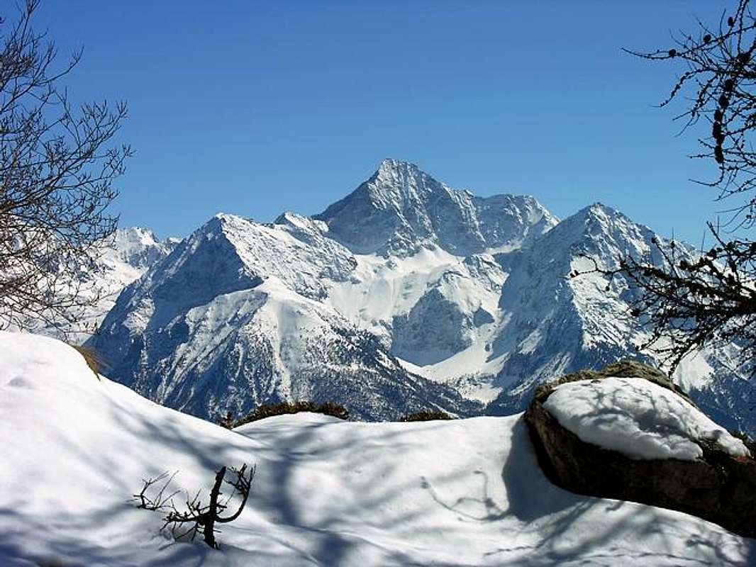
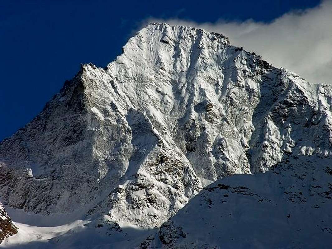
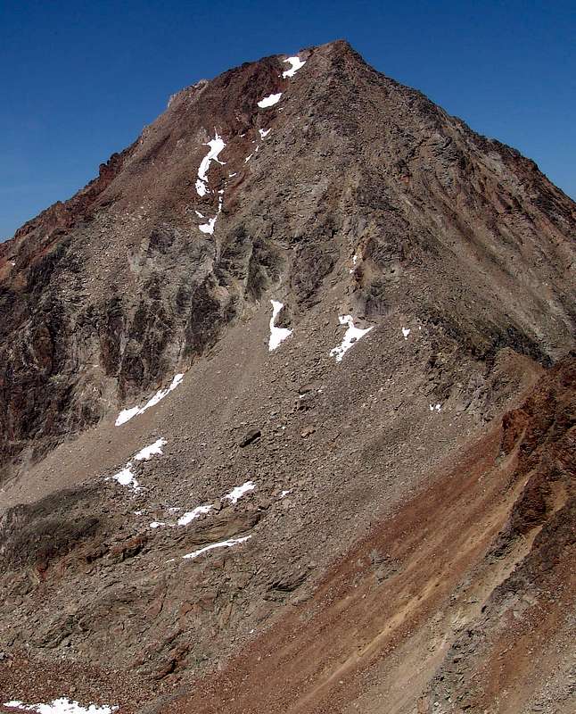
During the month of August many people climb Mount Emilius, but not in the other periods, in which there are few people and a great quiet! From the peak it is possible to admire a beautiful view to 360° on entire and complete Valley of Aosta. The Normal Route is quite easy, without technical passages, but it's necessary a few of experience to climb the last part on the ridge, because in some places quite exposed to Southeast, and often covered with fine debris on easy rocks through which the trail passes, (***watch the beginning of 2000, unfortunately, we have to record, confirming what was stated two fatal misfortunes, just above the Three Capuchins Pass and another three during the descent of the "Via Ferrata"). Do not underestimate. The construction of the Refuge and the constant "massification" of the route also involves this. Again, not to trivialize the climb and with regard to the West Ridge (once very rarely traveled) or "Via Ferrata", departing from Federigo Zullo Bivouac at Carrel Hill (2.907m; always open) remember to not deal with the bad weather because it is very exposed to lightning. Among the Normals remains the East Crest (most exposed and challenging, with steps up to the II°) starting at the Ménabreaz Shelter (2.546m) to Laures. By itself, above the Municipality of Grand Brissogne, you can, passing near Lake Dessus and Ghiacciato (Upper and Frozen), climb to Pass of Three Cappuccini by connecting with the way Pila. Moreover, you can also get from Gimillan ((1.787m; above Cogne-Resort) over the Garin Hill (2.815m) and also from the Grauson-Lussert Vallon via to the Hills Lussert des Laures (3.036m) and Arbolle (3.154m) by increasing even more the road, especially in the latter case with crossing on three vallons. In any case the "Via Classical" remains that by Pila (now facilitated by the presence of a comfortable refuge), of which we speak just below. Emilius is situated at South of Aosta, the main city of the region. From this turn to South and reach "Pila-Resort" (1.850 meters, reachable by car, bus or cable car) where you can take a telpherage that bring you until 2.300meters of altitude. You follow the signals to Chamolè Lake (2.325m) and then through a mountain pass at 2.641 meters of altitude you arrive to Rif. Alpe Arbolle, at 2.526meters, very confortable and where it's possible to sleep. The day after, you walk on the left of the Arbolle Lake and on a path you arrive to the feet of the mountain. At the cross-path with Arbolle Hill near a small lake (Lago Gelato 2.956m) you turn before left (North) and after right (East) and go up on a great moraine (heard the water gurgling beneath large boulders) that leads to the ridge (called "Crest of Trois Capuchins"). When you arrive to the ridge, nearby a homonym pass (3.241m), turn left and look the signals (!!) for don't loose the way (6 hours from Pila; 4 hours from Refuge Arbolle neighbor the Alp with the same name).
Durante il mese di Agosto molte persone scalano il Monte Emilius, ma non ugualmente negli altri periodi, in cui ci sono pochi alpinisti ed una grande tranquillità! Dalla vetta si può ammirare il panorama con ottime vedute completamente a 360° sull'intera Valle di Aosta. La via normale è abbastanza facile, senza passaggi tecnici, ma necessita d'un pò d'esperienza per salire l'ultima parte sul crinale, poiché in alcuni tratti abbastanza esposta a Sudest e spesso ricoperta da fine detrito sulle facili rocce interrompenti il sentiero, (*** attenzione agli inizi del 2000 purtroppo dobbiamo registrare, a conferma di quanto affermato, due disgrazie mortali, appena al di sopra del Passo dei Tre Cappuccini ed un'altra durante la discesa della "Via Ferrata"). Non sottovalutare. La costruzione del Rifugio e la costante "massificazione" del percorso comporta anche questo. Ribadisco, non banalizzare la salita e per quanto concerne la Cresta Ovest (una volta molto raramente percorsa) o "Via Ferrata", con partenza dal bivacco Federigo Zullo al Colle Carrel (2.907 m), ricordare di non affrontare la medesima con cattivo tempo perché molto esposta ai fulmini. Tra le vie Normali rimane la Cresta Est (più esposta, nonché impegnativa, con passaggi fino al II°) con partenza dal Rifugio Ménabreaz (2.546 m) alle Laures. Dallo stesso, sopra il Comune di Grand Brissogne, si può, passando nelle vicinanze dei Laghi Dessus e Ghiacciato, salire al Passo dei Tre Cappuccini effettuando il collegamento con la via da Pila. Inoltre si può arrivare anche da Gimillan ((1.787 m; sopra Cogne) attraverso il Col Garin (2.815 m) ed anche dal Vallone di Lussert tramite i Colli des Laures (3.036 m) e di Arbolle (3.154 m) così allungando ancor più la strada, soprattutto nell'ultimo caso con l'attraversamento di ben tre valloni. In ogni caso la "Via Classica" rimane quella da Pila (oggi facilitata dalla presenza d'un confortevole rifugio), della quale parliamo appena sotto. L'Emilius è situato al Sud di Aosta, la città principale della regione. Da questa indirizzarsi a Mezzogiorno e raggiungere il "Pila-Resort" (1.850 metri, raggiungibile in auto, bus o funivia), dove si può prendere una seggiovia che vi porterà fino a 2.300 metri d'altitudine. Seguite i segnali per il Lago di Chamolè (2.325 m) e poi, attraverso l'omonimo colle (2.641 m) s'arriva al Rif. Alpe Arbolle(2.526 m), molto confortevole e ove è possibile pernottarere. Il giorno appresso, si inizia camminando sulla sinistra del Lago Arbolle e su sentiero si perviene ai piedi della montagna. All'incrocio con la via per il Col d'Arbolle, nei pressi d'un piccolo lago (Lago Gelato 2956 m), si gira dapprima a Nord e poi ad Est salendo su d'una grande morena (senti l'acqua gorgogliare sotto i grandi massi) che conduce sul crinale (chiamato "Cresta dei Tre Cappuccini"). Quando lo si raggiunge presso un omonimo passo (3.241 m) girare a sinistra e guardare i segnali (!!) per non perder la strada (6 ore da Pila; 4 ore dal Rifugio d'Arbolle nei pressi dell'Alpe con identico nome).
First Ascents
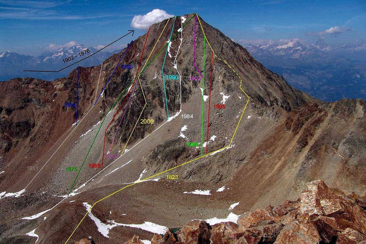
First on the Summit: Giovan Battista Defey, Lorenzo Cerise and a company unmentionable, (Summer 1823), in ascent from Arbolle Valley.
In winter: Lino Binel, Amedeo Berthod and Leonardo Cossard, (Feb 15th, 1934), in ascent from Arbolle through S-SE Crest.
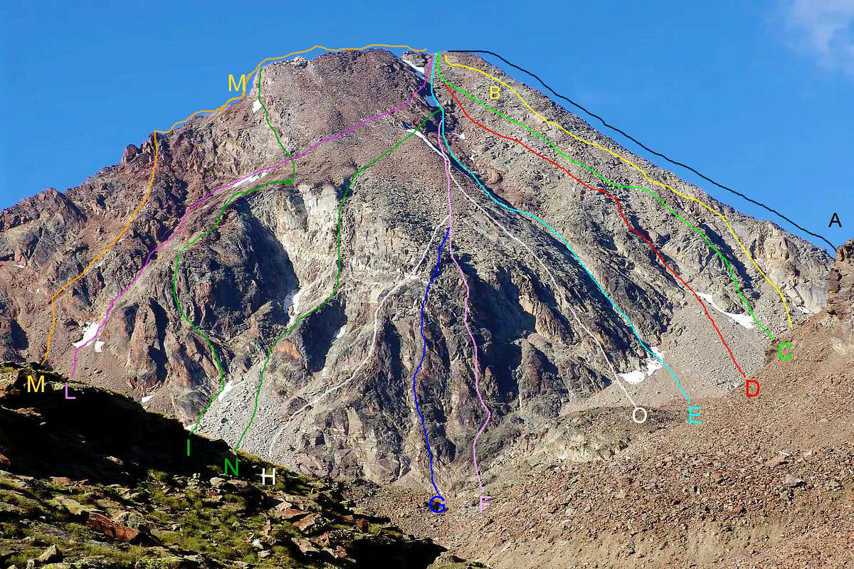
S-SE Arête ("Three Capuchins" Crest or Normal Route): Giovan Battista Defey, Lorenzo Cerise and a company unmentionable, (Summer 1823).
Variant under the Arête (West Side): Osvaldo Cardellina, Walter Ferronato, Ilario Antonio Garzotto and Luigi Neyroz; (Jul 18th, 1965), in descent; from Arbolle ancient Alp, E'cho' Loch, Gelato Lake.
Variant on S Slope and S-SE Arête (Western Side, in final part): Osvaldo Cardellina and Renzo Botti; (Jun 22th, 1968), in descent; in day from Pila.
Variant on Great rocky Couloir to right: Abbots Maria Joseph Henry, ? Bionaz and Grégoire Comé, Charvensod Mountain Guide; (Sep 02th, 1902,) in descent from Summit to Gelato Lake; in day from Pila.
S Slope (South "Little Couloir" and W Crest): Osvaldo Cardellina, lone, (Jul 08th, 1984), in day from Pila and Arbolle Vallon to Lago Gelato.
First repetition: it has been done (on June 14th, 1990), by Osvaldo Cardellina; with same route starting always from Pila Resort.
S Slope (South Spur - Southern Slope and W Crest): Osvaldo Cardellina, lone, (Jun 10th, 1990); in day from Pila and Arbolle Vallon
S Slope (Direct Line on S-SW "Ribbing pear-shaped"): Osvaldo Cardellina, Roy Cardellina and Danilo Garzotto; (Jun 19th, 1994); in day from Pila.
S Slope ( S-SW Wall on "Little Broken Pillar" and S Slope): Osvaldo Cardellina, solo; (Oct 07th, 2009), in day from Pila, Chamolé's Pass, Lago Gelato.
S Slope ("Large Pillar"- S Slope and W Crest): Osvaldo Cardellina, solo; (Oct 28th, 2006), in day from Pila, Chamolé's Pass, Arbolle Vallon, Lago Gelato.
S-SW "Sinuous Little Pillar" and S Slope (Direct Line to Summit): Osvaldo Cardellina, lone; (Jul 07th, 2007), in day from Pila, Arbolle Vallon, Lago Gelato.
W-SW "Great Pillar" and W Crest ("Direct Line to Grey Jump"): Osvaldo Cardellina and Danilo Garzotto, (Oct 11th, 1986), from Pila, Arbolle, Frozen Loch.
W-SW Slope ("Passaggio Corona"): Giuseppe Corona, Venanzio Defey and Charvensod Guide Grégoire Comé, (Sep 09th, 1875), from Pila, Lago Gelato.
First ? repetition: Osvaldo Cardellina, solo; (Oct 04th, 1992); in day from Pila, Chamolé, Arbolle, Boulders's Lochs; in descent by S-SE Crest to Gelato Lake.
South "Rib of Red Turrets" (about 3.450/60m) and W Crest: , Osvaldo Cardellina and Alessandro Cardellina; (Aug 10th, 1995); in day, Pila, Lago Gelato.
South Rib of Little Emilius and W Crest: , Osvaldo Cardellina, solo; (Oct 13th, 1968); in day, from Pila, Arbolle Vallon and Lago Gelato
S-SW Slope and W Arête: (Lake Gelato, SW Slope of "Little Saddle" 3.325m and W Crest): Giovanni Battista Bozzino and Carlotta "Tina" Bozzino ( Sep 12th, 1911), in descent from Monte Emilius.
SW Buttress and W Arête (Trident of Comboé-Punte del Lago Gelato-Mont Ròss de Comboé - Piccolo Emilius and W Ridge): Osvaldo Cardellina and Camillo Roberto Ferronato; (Aug 04th, 1974); in day from Pila and Arbole Vallon.
W Slope of Ròss Pass, S-SW Arête of Mont Ròss of Comboé and W Crest: Osvaldo Cardellina and Camillo Roberto Ferronato; (Jul 11th, 1977); in day from Pila, Chamolé Alpage, Colle Plan Fenetre, Comboé, Gros Scez.
W Wall of Mont Ròss di Comboé and W Ridge: Osvaldo Cardellina, solo, (Jun 06th, 1999) in day from Pila, Colle Plan Fenetre, Comboé, Plan Valé.
NW Ridge (from Carrel Pass through Mont Ròss de Comboé - Piccolo Emilius and W Ridge in final part): Abbot Joseph Maria Henry and Mountain Guide of Charvensod Grégoire Comé (Sep 16/17th, 1902) in descent from M.Emilius and in ascent from Col Carrel strarting Comboé; integrally in day Felice Mondini and Emilio Questa (Sep 20th, 1902), unaware of the previous climb starting directly from Aosta Town (!).
W Arête (N Wall Little Emilius): Giovan Battista Devalle, Ercole Daniele, Alessandro Pession and Luigi Bich, Valtournanche Guides, (Aug 30th, 1897), from Arpisson Alp; after the first absolute ascent through Western Face on Becca di Seneva, (Aug 29th, 1897).
N Wall and W Arête (Western Couloir): Osvaldo Cardellina, solo; (Aug 09th, 1998), from Pila and Federigo Zullo Bivouac.
N Wall (Pillar of Right): Renato Quendoz and Pino Trevisan, (Sep 27th, 1970), in ascent from Peckoz Shelter below Carrel Pass.
N Wall and W Arête (Central Couloir): Anselme Falcoz and Massimo Mila; (Summer 1940), from Peckoz Shelter.
N Wall and W Arête (Central Couloir and Left Pillar): Giulio Adolfo Ourlaz and Emanuele Tosana, (Autumn 1942), in ascent from Peckoz Shelter.
N Wall and N Edge (Pillar of Left with diagonal to N Edge): Lino Binel, Renato Chabod and Amilcare Crétier, (Aug 10th, 1926), in ascent by Peckoz Shelter.
N Wall and W Arête: Lino Binel and Amilcare Crétier, (Aug 21th, 1927), in ascent from Peckoz Shelter.
N Wall (Direct Line): Osvaldo Cardellina and Camillo Roberto Ferronato, (Aug 31th, 1980), in day from Pila.
N Wall (Superdirect to Summit): Osvaldo Cardellina, Sandrino Casalegno, Maurizio Castellan, Camillo Roberto Ferronato, (Jul 28th, 1984), in day by Pila.
N Wall and N Edge ("Mammellone" Via): Giulio Adolfo Ourlaz and Emanuele Tosana, (Spring 1942), in ascent from Peckoz Shelter.
N Wall (Black Triangle) and NE Edge: Angelo Bozzetti and Pietro Rosset, Valpelline Mountain Guides, (Sep 11th, 1960), in ascent from Comboé Alp.
N-NE Edge ("Three Curates" Crest): Abbots Georges "Louis" Bonin, Pantaléon Bovet, Joseph Henry and Nino Tofani, (Aug 02th, 1906), from Les Laures.
E Wall (Right Via): Ilario Antonio Garzotto and Renato Quendoz, (Jul 18th, 1969), in ascent from Ménabreaz Refuge.
E Wall (Central Route): Renato Chabod and Giusto Gervasutti, (Jun 26th, 1935), from Les Laures Alp, Blantsette moraine and Glacier.
E Arête ("Brissogne" Crest): Abbot Joseph Henry and Grégoire Comé, Charvensod Guide; (Sep 16th, 1902), in descent and ascent from Comboé.
NE Pillar and E Arête: (Variant from Blantsette Glacier to "Brissogne" Ridge): Osvaldo Cardellina, solo; Jun 30th, 1995, in ascent from Pila, Comboé, Carrel Hill, Federigo Zullo Bivouac, Arpisson Western and Eastern Glaciers, Testa and Col Blantsette to Blantsette Glacier.
SE Wall: Osvaldo Cardellina, lone, (Aug 06th, 1988), from Pila and through crossing Western / Eastern Slopes of Three Capuchins Pass.
SE Wall (S-S-E rocky Rib and E Crest in final): Osvaldo Cardellina, solo; Sep 27th, 2009; in day from Pila, Three Capuchins Pass; in descent S-SE Crest.
*** Note: lists only the major climbs up to the Nineties and also some from the 2000s but incompletely.
Getting There
Moving the cursor one can see the overall scene
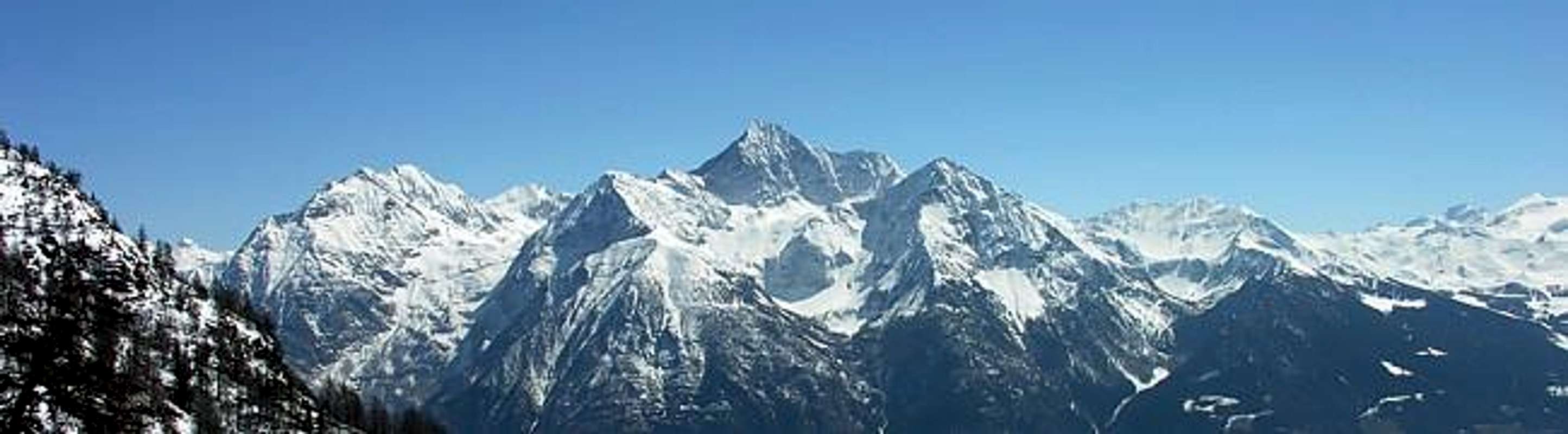
(1) Pointe Chermontane (2.683m)
(2) Punta Tersiva (3.515m)
(3) Cresta del Tessonet (3.311m)
(4) Punta del Tessonet (3.264m)
(5) Grand Avert (2.991m)
(6) Grande Crête (2.908m)
(7) Punta di Plan Rué (2.883m)
(8) Punta Gianni Vert (3.148m)
(9) Punte di Laval (3.091m/3.102m)
(10) Mont Corquet (2.531m)
(11) Mont Vallonet (3.098m)
(12) Punta I. Antonio Garzotto (3.274m)
(13) Grande Roise (3.357m)
(14) Punta Gianni Junod (3.300m)
(15) Petite Roise (3.279m)
(16) Becca di Salè (3.137m)
(17) Monte Emilius (3.559m)
(18) Becca di Seneva (3.086m)
BY CAR:
Highway A5 Torino-Aosta (99 km). Exit Aosta Est, then follow the regional road in the direction Pollein-Charvensod-Pila. From abroad: Via the Great St Bernard tunnel, then on State Highway SS.27 to Aosta or via the Mont Blanc Tunnel, then on State Highway SS.26 to Aosta. From Aosta, follow the signs to Gressan-Pila.
BY TRAIN:
From Turin or Milan to Aosta via Chivasso. The cable car to Pila is joined to the station by a short pedestrian subway.
From Switzerland: through the Grand Saint Bernard Tunnel or the namesake Pass.
From France: through Mont Blanc Tunnel or Petit Saint Bernard Pass. It isn't necessary to take Motorway A5: you can drive on SS.26, in the direction of Aosta.
BY PLANE:
Aeroporto "Corrado Gex"; Saint Christophe (Aosta).
Red Tape & Suggestions
You can leave your car in the free parking area near the telpherage in Pila or reaching this village by bus or telpherage from Aosta. No permit is required: these suggestions are good if you want to climb Emilius taking it easiest possible. As Chamolè telepherique stops at 17'00 or 17'30 in high season (take a look for schedule time at www.pila.it) I think it is good to optimize your two days this way.
First day: once arrived in Chamolè, walk the steep path to Chamolè Pass e get down to Arbolle plan, 150 meters down to the Southeast. Light your rucksac at Refuge and climb Emilius. You'll have good chance to arrive at summit and back to the Refuge without rush. Have a good dinner, Refuge Arbole is one of best gourmet refuge in VdA (this is not essential, but helps!).
Second journey: next day, walk back to Chamolè Col and, just before arriving on it, turn left for Punta Valletta (3.090m; yellow panel). There is a long path traced on the large ridge from Testa Nera (Black Head; 2.820m). In 1h and 30 mins you'll get your second edge in two days. You'll have all the time required to arrive at Chamolè telepherique before last run. If you need more infos: beppebusso@libero.it ------ Climbing Emilius in a day and get back to Chamolè for 17'00/17'30 need a great effort and, for sure, no time for the spectacular view on the summit (in the morning the earliest you get in Chamolè is 9:00 ...). If you have only one day and you don't want to hike to Chamolè Col (this means that you surely miss the date with time closure in Chamolè. Teleph.), you can follow path n°16 very close to Arbole Refuge (100 meters to the Northwest from shelter). Once a very steep descente in a gully has ended, you'll reach Comboè plan. Cross this beautiful plan and walk toward Col de Plan Fenetre. Once pass the col, there are two possibilities:
1) - continue half way a path that returns you in Chamolè zone (not just at the arrive of telepherique, but half a way), or
2) - go down to San Grato, a nice and tiny church. A two kms unpaved road to West bring you back to Chamolé departure. Telephone.
È possibile lasciare l'auto nel parcheggio gratuito nei pressi del piazzale della Cabinovia a Pila oppure si può qui giungere in autobus da Aosta. Non è richiesta autorizzazione. Questi suggerimenti sono validii se si vuol rendere l'ascensione all'Emilius il più semplice possibile: la Seggiovia per la Stazione di Chamolè chiude, in base al periodo, alle 17'00 o 17'30 in alta stagione (date un'occhiata per tempo al programma a www.pila.it) penso sia bene ottimizzare i due giorni in questo modo.
Primo giorno: una volta arrivati a Chamolè, percorrere il sentiero abbastanza ripido verso il Colle di Chamolé e scendere verso il Vallone di Arbolle, circa 150 metri verso Sudest. Preparati il tuo zaino al Rifugio e sali all'Emilius. Avrai buone possibilità d'arrivare in vetta e ritornar al rifugio, senza alcuna fretta. Si prospetta una buona cena, poiché il Rifugio d'Arbolle è uno dei miglior rifugi per quanto cencerne il "gourmet" in Val d'Aosta (questo non è essenziale, ma certamente aiuta!).
Seconda giornata: il giorno dopo, tornando indietro al Colle di Chamolè, appena prima di arrivare su di esso, svoltare a sinistra per la Punta della Valletta (3.090 m; cartello segnaletico giallo). C'è un lungo percorso tracciato sulla lunga cresta dalla Testa Nera (2.820 m). In 1h'30 otterrete la vostra seconda traversata in cresta in due giorni. Avrete tutto il tempo necessario per arrivare alla seggiovia di Chamolè prima dell'ultima partenza. Se abbisognate di maggiori informazioni: beppebusso@libero.it ------ La salita all'Emilius in giornata con rientro a Chamolè per le ore 17'00/17'30 richiede una bella sfaticata e, di sicuro, non c'è molto tempo per gustarsi le spettacolari veduta dalla vetta (al mattino la prima partenza della seggiovia per Chamolè è intorno alle 9h'00...). Se disponete d'un sol giorno e non si vuol rientrare tramite il Colle di Chamolè (questo significherebbe di mancare quasi certamente l'appuntamento con l'ultima corsa da Chamolè. Telefono.). Si può invece seguire il sentiero n° 16 appena dietro al Rifugio (100 metri a Nordovest dal medesimo). Dopo una discesa piuttosto ripida in una gola si arriva al pianoro di Comboè. Attraversare questo bel vallone risalendo verso il Col Plan Fenetre. Una volta scavalcato il colle, esistono due possibilità:
1) - continuare tramite il sentiero con un lungo diagonale dapprima all'Alpe di Chamolè (a circa metà strada del percorso con la Seggiovia) donde a Pila, oppure
2) - scendere alla bella Chiesetta di San Grato; donde una sterrata di circa due chilometri verso Ovest riconduce al punto di partenza. Telefono.
Difficulty and Equipment
Difficulties In respect of S-SE Crest or Standard Route, this route can be considered F/F+ with a brief steps of PD-/PD if with integral route on the thread of the crest.
A riguardo della Cresta S-SE o Via Normale, l'itinerario è classificato F/F+ con brevi passaggi di PD-/PD se con percorso integrale sul filo di cresta.
Equipment Hiking gear (spare rope only in case of snow presence).
Da Escursionismo (corda necessaria solo in caso di presenza di neve).
Mountain Conditions
Meteo: you can find all the needed informations at the official site of the Valle d'Aosta Region:
The best season to climb Mount Emilius is between July and August. In this period it is not necessary to bring with you the alpinism-equipment. But in other periods it's possible to find snow and even ice on the ridge before the peak that would be dangerous for your ascent (necessary crampons).
La stagione migliore per scalare il Monte Emilius è a cavallo tra i mesi di Luglio ed Agosto. In questo periodo non è necessario portare con voi particolare attrezzatura alpinistica. Ma in altri periodi è possibile trovare neve od anche ghiaccio sulla cresta prima della vetta che rende ben più insidiosa la salita (ramponi necessari). Pila Infoline: Tel. +39 0165 521148 +39 0165 521045 Fax +39 0165 521437 Mail: info@pila.it
Telephone: +39-335-6844703 and 0165-34423. Open from June to September. In spring-time, for ski-moutaneering, open on demand. Places when open: 66 Winter hut: 18 places EXCURSIONS Lago Gelato 3.019m Vallone di Comboé 2.100m Col Garin 2.815m CROSSINGS Bivacco Grauson 2.540m Bivacco Federigo 2.897m Bivacco Menabreaz 2.546m ASCENTS Monte Emilius 3.559m P.ta Garin 3.448m P.ta Rossa 3.401m
Books and Maps
BOOKS:
"Guida del Monte Emilius", di Osvaldo Cardellina Editore in collaborazione con il Club Alpino Italiano Sezione di Aosta, Dicembre 1978.
"Guida dei Monti d'Italia – Emilius Rosa dei Banchi Parco del Mont Avic" di Giulio Berutto e Lino Fornelli - Club Alpino Italiano/Touring Club Italiano, Marzo 2005.
"Guida delle Alpi Occidentali" di Giovanni Bobba e Luigi Vaccarone C.A.I. Sezione di Torino Volume II (parte II), 25 Maggio 1896.
"80 itinerari di Escursionismo Alpinismo e Sci Alpinismo in Valle d'Aosta", di Osvaldo Cardellina, Ed. Musumeci, Giugno 1977 (in Italian); seconda Ed. Luglio 1981; terza Ed. Luglio 1984; (in French), prima Ed. Febbraio 1978; seconda Ed. Marzo 1980.
"Diari Alpinistici" di Osvaldo Cardellina e Indice Generale accompagnato da Schedario Relazioni Ascensioni 1964-2019 (inediti).
MAPS:
Kompass "Gran Paradiso Valle d'Aosta Sentieri e Rifugi" Carta turistica 1:50.000.
L'Escursionista "Conca di Aosta-Pila-Monte Emilius" Carta dei sentieri (n° 4) 1:25.000.
Hapax "Les Sentiers Comunità Montana Monte Emilius", Luglio 2000 1:25.000.
Enrico Editore Ivrea-Aosta "Gruppo del Gran Paradiso" 1:50.000.
I.G.C. Istituto Geografico Centrale, Torino "Carta delle Passeggiate ed Escursioni in V.D.A. Conca di Pila-Gressan, 1:20.000.
External Links
More about Emilius Another description with 40 shots, 6 panoramas and a "handmade" map, about Emilius.
Pila web-site Pila, the famous winter station, has an active life even in summertime. In this link, you'll able to find time schedule for Chamolè Chair Lift.
Children refers to the set of objects that logically fall under a given object. For example, the
Aconcagua mountain page is a child of the 'Aconcagua Group' and the 'Seven Summits.' The
Aconcagua mountain itself has many routes, photos, and trip reports as children.
Parents refers to a larger category under which an object falls. For example, theAconcagua mountain page has the 'Aconcagua Group' and the 'Seven Summits' asparents and is a parent itself to many routes, photos, and Trip Reports.

 34499 Hits
 95.51% Score
 53 Votes