
-
 130147 Hits
-
 96.38% Score
-
 60 Votes
|
|
Mountain/Rock |
|---|---|
|
|
38.07170°N / 107.4614°W |
|
|
14314 ft / 4363 m |
|
|
Overview
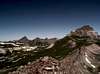
Uncompahgre Peak is the 6th highest mountain in Colorado. Uncompahgre Peak is also the highest peak on Colorado's Western Slope and is the highest point of Hinsdale County. It is located in the San Juan Mountain Range which is located in the southwest part of Colorado. The San Juans cover a large area and you can really get a feeling of escape out here. Several of the fourteeners in this range can be a little difficult, but Uncompahgre is probably one of the easiest ones to climb. It is also interesting to note (as pointed out by Diggler and Aaron Johnson) that the entire Northern San Juans are of volcanic origin. This includes Uncompaghre.
 |
 |
 |
 |
 |
Getting There
From Denver, take 285 south until you reach Poncha Springs. Head west until you reach the Colorado 50/Colorado 149 junction a few miles west of Gunnison and then head south to Lake City. Once in Lake City, follow the sign to Engineer Pass. Once you reach a dirt road called Henson Creek Rd (aka Hinsdale County Road 20), go about 9 miles to Nellie Creek Rd and turn right. The road from here is a 4WD road - I would not recommend trying this road without 4WD. If you start hiking at the start of the 4WD road it is a 15 1/2 mile hike with 5000 feet elev gain and makes for an extremely long, hard day. From the 4WD parking lot, it is a 7 1/2 miles hike, 2800 feet elev gain. This is the Nellie Creek trailhead.
The alternate Matterhorn Creek trailhead allows access to both Wetterhorn's south side and Uncompagre's west side. This trailhead is recommended if you want to try climbing both in one day. To reach this trailhead start out as for the Nellie Creek trailhead, but on Henson Creek Rd continue past the Nellie Creek Rd about 4 more miles until you reach the North Henson Creek Rd in the old Capitol City townsite. Take the North Henson Creek Rd (FS 870) 2 miles to the Matterhorn Creek trailhead. Most people park here. From here there is also a .6 mile 4wd drive trail that can take you to 10,720 ft and a parking area below the Forest Service Gate.
 |
 |
 |
 |
 |
Mountain Conditions
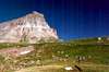
The hike up Nellie Creek road is Class 1, but it is a real slow slog. The start of the route from the Nellie Creek trailhead (4WD parking lot) starts as Class 1 and later becomes Class 2. Right before the final summit ridge stretch there is a small portion of the trail that might be 2+ as the trail dodges cliffs between 13,800 and 14,000 feet. The trail is well worn and easy to find. This is one of the easier, more popular peaks and attracts a large amount of climbers. The distinctive shape of Uncompagre is also an attraction. The summit is a large plateau-there must have been 50 people on the summit the day we climbed it. The route from Nellie Creek is also called the East Slopes Route. There are some incredible views from the summit- especially if you lie down and look right over the edge. Careful- dont get too close to the edge while you are standing...its a long ways straight down.
The alternate route starts from the Matterhorn Creek trailhead. It is a longer route than The East slopes Route, but allows you to climb both Uncompagre and Wetterhorn together. This is also a class 2 route. From Matterhorn Creek trailhead it is a 14 mile climb with 4300 ft elevation gain. If you proceed to the 4wd parking lot at 10,720 ft it is a 12.8 mile trek with 3980 ft gain. Just remember mountain conditions can change rapidly, especially in the afternoon. Be especially mindful of conditons if you are going to try both Uncompagre and Wetterhorn together.
Conditions on this mountain, like all Colorado 14ers, are subject to change rapidly- especially during the prime climbing summer season. The mountains are their own weather system, and weather forecasts from nearby towns often have little to do with actual mountain conditions. You can generally count on clear to partly cloudy in the morning, and heavy clouds and thunderstorms in the afternoon during the summer climbing season. The following weather forecast is included as a GUIDE. Expect conditions in the mountains to be no better- and possibly much worse. NOTE: The weather site is temporaily unavailable due to technical difficulties.
There is no substitute for getting an early start, and getting as much of the mountain "behind you" as early in the day as possible. Keep a good eye on the sky as weather conditions can deteriorate rapidly. The greatest weather danger is from lightning strikes, and climbers are killed almost every summer in Colorado by lightning strikes. July seems to be the most deadly month for lightning.
Two climbers were killed by lightning in Colorado within a couple days of each other in the summer of 2003. I think the following important information from Gerry Roach's book "Colorado's Fourteeners From Hikes to Climbs" bears repeating. Added here with permission from Gerry Roach:
Colorado is famous for apocalyptic lightning storms that threaten not just your life, but your soul as well. This section will have special meaning if you have ever been trapped by a storm that endures for more than an hour and leaves no gap between one peal of thunder and the next. The term simultaneous flash-boom has a very personal meaning for many Colorado Climbers
Dangers
1. Lightning is dangerous!
2. Lightning is the greatest external hazard to summer mountaineering in Colorado.
3. Lightning kills people every year in Colorado's mountains.
4. Direct hits are usually fatal.
Precautions
1. Start early! Be off summits by noon and back in the valley by early afternoon.
2. Observe thunderhead buildup carefully, noting speed and direction; towering thunderheads with black bottoms are bad.
3. When lightning begins nearby, count the seconds between flash and thunder, then divide by 5 to calculate the distance to the flash in miles. Repeat to determine if lightning is approaching.
4. Try to determine if the lightning activity is cloud-to-cloud or ground strikes.
5. Get off summits and ridges.
Protection
1. You cannot outrun a storm; physics wins.
2. When caught, seek a safe zone in the 45-degree cone around an object 5 to 10 times your height.
3. Be aware of ground currents; the current from a ground strike disperses along the ground or cliff, especially in wet cracks.
4. Wet ropes are good conductors.
5. Snow is not a good conductor.
6. Separate yourself from metal objects.
7. Avoid sheltering in spark gaps under boulders and trees.
8. Disperse the group. Survivors can revive one who is hit.
9. Crouch on boot soles, ideally on dry, insulating material such as moss or grass. Dirt is better than rock. Avoid water.
The following link is also helpful: Lightning Safety and Crouch
Also see this report. It will make you really think about lightning safety: Struck By Lightning!
 |
 |
 |
 |
 |
Camping
The main place to camp is along the 4WD drive Nellie Creek Road. There are numerous sites along this road. If you don't have 4 WD there is a very small campsite right near where Nellie Creek Rd turns off from Henson Creek Rd. It is right along Henson creek , but there is only room for 2-3 cars and about as many tents. This is the only camping site allowed along the Henson Creek Road. We camped here and then drove up Nellie Creek Road to the trailhead in the morning.
 |
 |
 |
 |
 |
When To Climb
The best time to climb is summer. June to- September are prime times. Try to climb early in the day as the afternoons in Colorado are famous for afternoon thunderstorms. Try to climb during the week if possible to avoid the larger weekend crowds.
 |
 |
 |
 |
External Links
COLORADO 14ERS INITIATIVE LEARN MORE ABOUT COLORADO 14ERS AND VOLUNTEER OPPORTUNITIES
Leave No Trace
Check out the web site of LNT and learn some important minimum impact hiking tips.
Colorado Mountain Club
CMC’s web site will tell you all you need to know about Colorado’s largest and oldest hiking club.
- Uncompahgre/Wetterhorn
- Uncompahgre Peak
- Uncompahgre Peak (08/12/2005)
- 14ers.com - The Home of Colorado's Highest Peaks
Fourteener Photos, Route Descriptions, Forum, and more... - Wetterhorn and Uncompahgre