
-
 15882 Hits
-
 82.48% Score
-
 15 Votes
|
|
Mountain/Rock |
|---|---|
|
|
46.48750°N / 13.99377°E |
|
|
Hiking, Skiing |
|
|
Spring, Summer, Fall, Winter |
|
|
6204 ft / 1891 m |
|
|
In Slovenian language č, š and ž are pronounced like ch, sh, and zh. Our mountain is written Dovška Baba.
Overview
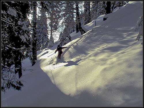 Skiing through the woods from Dovska Baba.
 Baba from the east
 The southern slope
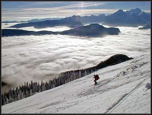
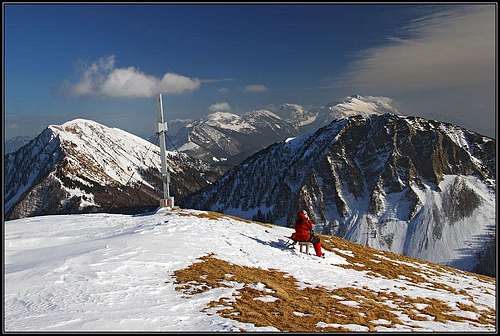
The first ski tour in a season always has a special, almost sacred meaning. And in the Upper Sava valley this is very often from the mountain, named Baba (means: old woman). In a long mountain range of Karawanks there are many ideal ski summits. They all excel with a beautiful panorama and above the Upper Sava valley this is even more dramatic, because on the other side of the valley, towards the south, the whole mountain group of Julian Alps rises. You can convince yourself of this from pictures on this page.
The name of our mountain comes from a small village Dovje, on the Slovenian side. From there, one can use a forest road and when you reach high enough, on snow, you put on skis and continue comfortably to the top. That is why this mountain is one of the most popular ski goals in early winter. In a good winter the southern road turns into a good sledge piste. So, if you ascend the summit without skis, why not taking with you sledges, perhaps even wait for a moon rise and then whooosh down! Of course Baba can be ascended also in any other time of the season. Especially beautiful time is autumn, when long hikes over the main Karawanks ridge are recommended.
A Short Geography of Dovška Baba
 Koprivnjak
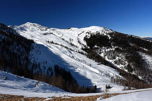
North-west of the summit, on the main ridge of Karawanks, the Mlinca saddle separates Baba from the massif of Kepa / Mittagskogel. The ridge from Mlinca saddle to the summit of Baba is steep and crubmly, almost noone goes there. In the past a trade route over it connected Carbiolia and Carinthia, now almost nobody crosses it. The two valleys, descending from Mlinca saddle are:
- To the S-SW goes the pathless valley of Mlinca creek. A trail comes up along its W border and is not much suitable for Baba ascent.
- To the N-NE descends the valley of Rdečica. Cart roads are reaching its upper parts and a non-marked path the saddle itself. It's a rarely frequented area, there are only two hunters huts.
From the summit of Baba towards the south-west a gentle grassy ridge descends on Dovška Rožca meadow, where the mountain hut stands. Further down this side ridge soon gets forested and above the village of Dovje there are some lower summits in it. One of them has a 90 meters high rock of Bvaščeva (Blažčeva) skala, 1091 m. It stands just above the road and is a fine panoramic point over the Upper Sava valley. In its south oriented crags there's also a climbing area.
The main Karawanks ridge continues from the summit of Baba towards the east (and soon towards the south-east) on the nearby Hruški vrh, 1776 m. This ridge hosts a panoramic marked trail. More eastwards of Hruški vrh there's the saddle Rožca, 1587 m.
From the main ridge, just east of Baba's summit, another side ridge deters towards the north-east. It's running on the gentle summit of Koprivnjak Kleiner Frauenkogel, 1754 m, again a fine grassy slope for tour skiing.
The upper N slopes of Baba and the NW slopes of Koprivnjak ridge are very steep, rocky and crumbly. Nobody goes over there.
Towards the S, the upper slopes from Dovška Baba are first descending very gently. Only some 400 m lower, they get steepar, cut by many ravines, falling down into the Presušnik creek valley-end. That's a wild and abandoned area too. Just above the valley branching, on some 1200 m of altitude, there's the interesting Presušnik waterfall. It can be easily reached by the patghless valley from below. From the point, where the mountain road crosses this creek, we go up the stream some 30 minutes and reach a dark corner, where there's a 12-meters high waterfall. But it's worth of a visit just in spring, when snow is melting, or after a considerable rain.
Finally, towards the NE the long valley of Bärengraben is descending - all the way to the Drau/Drava valley. The upper slopes of this valley are forming a nice, broad cirque, belonging to the summits: Koprivnjak, Dovška Baba, Hruški vrh and Klek. In all times of season the valley is quite frequented, at its end there's the still live pasture of Roschitza alm / Rožca.
Getting There and the Tours on Baba
 The upper slopes of Dovška Baba - in the distance are Julian Alps
 Baba from the NE, from Koprivnjak
Getting to trailheads
From the south, Baba is most often reached from Dovje, the village in the Sava valley. It is located just a few kilometers west from the south portal of Karavanke tunnel. Of course you can also arrive there from the west - from Tarvisio (Italy) or Villach (Austria - over the Korensko sedlo / Wuertzen Pass). How far you can drive further up the mountain road above Dovje? Well, in winter it depends on snow conditions, but maximum to some 1150 m.
From the north (Austrian side) Baba can be reached from Rosenbach, near the north portal of Karawanks tunnel. There you should find a forest road, which brings you towards the south into one of two valleys, which end below the slopes of Baba. These roads are better used in summer and autumn than in winter.
Finally an also useful trail head is in the Planina pod Golico village, reachable directly from Jesenice tow. From there, or from the mountain road over the Na Visokih pass we first walk up on the main ridge (Hruški vrh) and then further on Baba.
Marked routes
1. From the south a mountain road (at the end cart-road) reaches the Dovška Rožca hut, 1649 m: Dovje (704 m) - Ravne (1120 m) - alpine meadow Dovška Rožca (1640 m) - Summit. But the road is closed already deep down below the pasture. From the village of Dovje, we drive by the mountain road towards the east, crossing the Mlinca creek and many nice meadows. Just before the creek of Presušnik, on 1080 m, there's another crossroads. There we deter left up, towards the Ravne hamlets. Soon there is a sign, prohibiting to continue the drive. We can park there, on some 1120 m (46.469331, 13.988474), or a bit higher on the road, before the ramp, which definitely stops us to drive on. The path is also marked. In summer you can also use a marked path to the Mlinca saddle (1581 m) and from there continue towards the east to the summit.
|
2. From the north: Rosenkogel Huette (1410 m) - Rožca saddle (1587 m) - and towards the west to the summit - crossing Hruški vrh. You can also use the unmarked path, which reaches Mlinca saddle from the north. 3. Over this part of Karavanke range there goes the marked long-distance trail in the east-west (or vice versa) direction. So you can reach the summit of Baba from the prominent peak of Kepa (on the west) or from Golica (on the east). This hike is very panoramic, and so recommended in autumn. Here are also the two classical maps:
Left is my U-Map (OpenStreet Map) which is at the same time also a guidebook and is pecise enough to be used for orientation. But make sure to have the offline access to it on your phone. |
 |
 |
 |
 |
 |
Koprivnjak
 On the summit of Koprivnjak
 Koprivnjak
 Mlinca saddle from Koprivnjak
As mentioned, Koprivnjak is a humble (towards the south) mountain in the NE side ridge of Dovška Baba. If in winter we are ascending from the north, from Rosenbach / Podrožca, and we don't have a tour skiing equipment, we shall perhaps not attempt the ascent on the main ridge, as in winter there nobody walks on foot. In such a case Koprivnjak can be a very nice goal of a ski tour, as it has easy, south oriented slopes. Of course Koprivnjak is a nice trip goal also in summer, when from its summit we can prolongate the tour for example on the main ridge, then on Baba and perhaps traverse Hruški vrh and return over Rožca saddle. In winter the whole area is ideal for tour skiing, only the ascent is quite long.
The tour
From Rosenbach / Podrožca, where we park on 600 m, we go towards the south in Medji dol. The mountain road is ascending slowly along the creek, then on 940 m we reach a crossroads, where the left road goes on Kladje alpine meadow. We continue right across the creek and then by the road up the slopes. The trail does a few shortcuts, finally the road traverses the slopes of Koprivnjak and reaches the Rožca alpine meadow. The huts are a bit below us. The marked trail goes on tthe summit of Koprivnjak even before, by the hunters hut, but the ski tour is most beautiful towards the south, on the alpine meadow. 3 h to 3 h 30 min for the ascent. For a real tour skiing only the upper 250 m of altitude are very beautiful, the rest goes by the mountain road. if we don't want to carry the whole equipment, we can do the tour also with short skis. In summer we can also opt for a mountain bike ascent.
Red Tape
 Alex Vega - Amaníta muscária
No limitations.
When To Climb
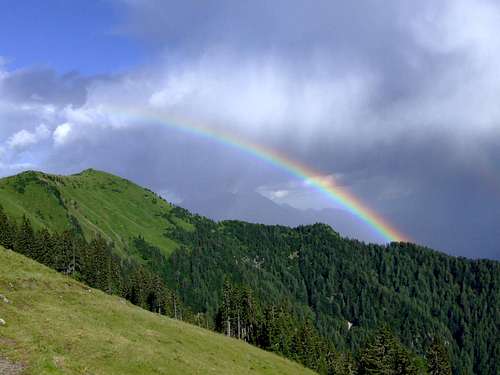 Janez - After a storm
Baba can be reached the whole year, although the best time is during the tour ski season and in autumn. Weather: see here.
 |
 |
Camping
 On Dovška Rožca
 mtncorg - The hut
Because the ascent is short, you don't need to sleep on the mountain. On the south side there are a few private huts and on the east (Austrian side) there is the Rosenkogel Huette (1410 m). In the Sava valley there are camps in several villages: Jesenice, Dovje, Martuljek. You can also stay in many hotels of Kranjska Gora, for example hotels: Lek, Larix, Kompas and many family hotels. A few general facts for tourists and about camping you can find here.