
-
 30380 Hits
-
 90.81% Score
-
 33 Votes
|
|
Mountain/Rock |
|---|---|
|
|
46.43370°N / 14.17420°E |
|
|
Hiking, Mountaineering, Trad Climbing, Scrambling, Via Ferrata, Skiing |
|
|
Spring, Summer, Fall, Winter |
|
|
7335 ft / 2236 m |
|
|
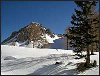
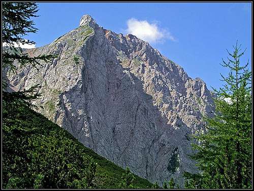
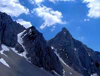
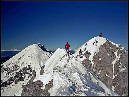
Overview
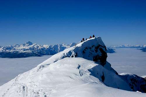
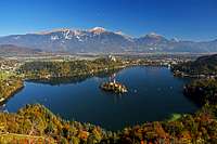
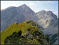
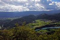
From the S, with Bled
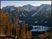
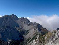
From the north
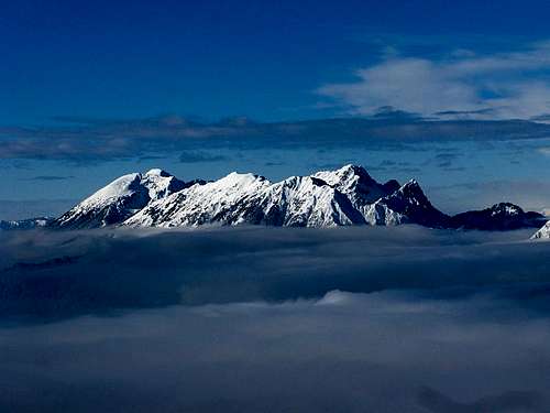
From the E (Vrtača)
What's New On This Page?
> Jan 13th, 2021: Interactive map-guide embedded.
> Jan 24th, 2019: Design corrections.
> Sep 19th, 2015: Google map added
> Sep 9th, 2015: Ajdna chapter updated
> 2005-2011: Page redesigns, images embedded.
General remarks:
When reading Slovenian words on maps or in books, you will find special characters for ch, sh, and zh. They are written with c, s and z with a caron - little v above them - like this: č, š, ž.
On this page I shall describe not only Stol/Hochstuhl summit but also some minor mountains in its narrow group.
Overview
Stol is the highest mountain in the about 120 km long Karawanks Range by which the border between Slovenia and Austria runs. In their highest part, Karawanks are exhibiting already a high alpine character (otherwise they are milder). And Stol / Hochstuhl is a typical mountain of this range.
Stol / Hochstuhl sends high grassy and rocky slopes towards the south. Some 1000 meters below the summit these slopes flatten for a while on a nice terrace with beautiful, panoramic meadows. Then the forested and partially rocky slopes descend another 600 meters towards the valley of Sava river and the valley of Završnica. On the southern slopes you can find several interesting features. Towards the summit, there are fine, steep ravines, separated with some picturesque rocks. Below are sunny, still very panoramic alpine meadows. In the lowest part there are several hills, keeping their old memories and secrets.
Towards the west, Stol / Hochstuhl sends a strong ridge towards Vajnež. This is the main ridge of Karawanks, which on the other side continues in the norteastern direction towards Vrtača saddle.
The northern side of mountain is rocky and steep. Stol / Hochstuhl is not attractive for rock climbing - it can be done in the neighbouring walls - but the northern side offers all the rest: a nice, playful ferrata, steep ravines for spring snow base climbing, less demanding, but still steep passages on the main ridge, by which tour skiing of all difficulties is possible.
In its close neighbourhood there are many mountain huts which make the ascent more pleasant. By the nature of Karawanks range, the most beautiful are traverse tours - if you have a few days, you can walk on quite a high altitude, enjoying free panorama towards the south and north.
Besides being frequently visited in summer and autumn, Stol offers also many possibilities for tour skiing. Because the northern slopes are not only rocky, but on some places scree terrain reaches the crest itself, steep ski tours are especially beautiful towards the north. Towards the south and east, skiing is possible through many more or less steep ravines and valleys.
Geologocally, Stol / Hochstuhl summit is built of late Triassic limestone, called Dachstein limestone, with some embedded dolomite layers. In lower parts, especially in the southern side, older limestones are on the slopes as well (Permian and Triassic), but also a belt of younger Jurassic limestones stretches below the main ridge.
Geography of the Narrow Group
To zoom-in and zoom-out you can also use the small mini-map in the bottom-right corner.
Stol/Hochstuhl narrow group begins on the west on Medvedjak saddle, 1698 m, which separates it from the Struška massif. From Medvedjak the main ridge goes towards the SE to the summit of Belščica, 2017 m and further to Vajnež, 2104 m, the most important neighbour of Stol on the west. SE of Vajnež, there's the Vajnež saddle, 1972 m, where also a descent towards the N is possible from the main ridge. Vajnež is attached to the main Stol massif on the summit of Potoški Stol, 2014 m. From this unimportant summit to Stol a narrow ridge goes, from which two steep passages are possible towards the northern screes (Dolga Riža and Široka Riža). Just before the summit of Stol, 2236 m, from the north a steep, rocky ridge comes, carrying the popular north ferrata.
SE of the main summit Mali Stol, 2172 m, is standing (with a hut just below its summit). From the highest Stol summit the main Karawanks ridge continues towards the NE. This ridge is known as Orlice and carries a few sharp and hardly approachable peaks. Beyond the first few notches there's a sharp and beautiful Celovška špica / Klagenfurter spitze, 2105 m. The next notch separates it from the double summit of Jelenčka / Edelweiss Spitzen and these are followed by Belščica saddle, 1840 m. From the notches of Orlice it is possible to descend down on both sides, easy towards the south and through steep and more demanding ravines towards the north. Belščica saddle is easy of course on both sides. Finally, N of Belščica there's a nice summit of Svačica, 1953 m, where the main Karawanks ridge turns again towards the east on Vrtača saddle, 1845 m, where the narrow Stol group ends and Vrtača / Wertatscha massif begins. North of Svačica there's Vrata pass, 1712 m, where Stol massif is separated from lower mountains on the north (Kozjak / Geissberg).
Summit Panoramas
Stol / Hochstuhl is very know by its broad panorama. The views fly on one side till the mountainds of Gorski Kotar (Dinaric Alps), to the summits in Istria, then to Julian Alps, which are the most beautiful part of the panorama. Further clockwise you can see Hohe Tauern, Gurktal Alps and on the north Dachstein. More close to us are numerous summits of Karavanks, the most picturesque is the view on Košuta range.
 |
 |
 |
 |
 |
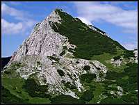
From Ancient Times: Ajdna
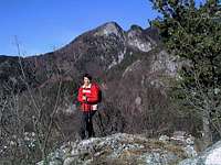
Ajdna behind

Before the very southern slopes of Stol there is a steep rock, called Ajdna, 1046 m. Ajd means in Slovenian a pagan (I think in German there is a similar word Heide). On the top of this rock archeologists discovered rests of a village from late antiquity, namely, its hey time was from the 5th to the 6th century a.d. The rock was accessible only from one side, and on the top of it, some 450 m above the Sava valley, ancient houses and a church were discovered. Nowadays this site is reconstructured to a certain degree, just to boost visitors' imagination. So, if you travel around and see a lot of steep hills around the mighty Stol, you can think that perhaps on some of them 2000 years ago people lived.
The story of Ajdna. The oldest artifacts originate from the stone age. A stone axe from some 3000-2000 years B.C. was found there. In the Ancient Roman times there the fortified settlement was established and after the collapse of imperium, it gained its importance. While the towns in the valleys saw the raids of Germanic and Slavic people, invading the Roman Empire, the romanized people found shelter on those hardly accessible rocks above valleys. Just belov the top of the rock there were some 20 houses and a paleochristian church. The church had one nave and an elevated place for priests. People lived of agriculture, keeping herds and also of iron-mining. Items found in layers from that period of time reveal frequent contacts with Germanic people. Towards the end of the 6th century the settlement was abandoned. Burnt houses and a skeleton with a spear tip among bones reveal a violent end of the settlement, probably by invasion of Slavic people. Later, in the 9th century, Ajdna was inhabited again. Its story is very similar as the story of Gradišče nad Bašljem (a similar fortified settlement below Storžič). In that time the hill was used as a fortified military place (not unlike future medieval castles), used by Slavic noblemen, offering resistance to the Franks, who ultimately prevailed.
The ascent on Ajdna is a short and rewarding hike. On the road below Valvasor Hut we take a left branch and soon come to the place where the marked path deters left. When reaching below the rock, we can decide either for a short ferrata (carefully!) or the easier path right around. The third option is the path from the valley, from Potoki village, 600 m, SW of Ajdna.
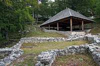 Archeologic site |
 The view from Ajdna |
 The N ascent |
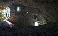 Turkish cave |
The Turkish hole. In lower part, on the SW slopes of Gozdašnica hill (on 835 m), there is another small attraction. A mountain cave was in the middle ages fortified and served during Turkish raids to civil people as refugium. The site is quickly reachable. By the road Završnica - Valvasor hut, we go (or drive) only to a sharp left turn. There the plate directs us right, on a weak path. In 5 minutes we reach the hole. The path is narrow and requires attention and safe step (T3 grade).
Getting There
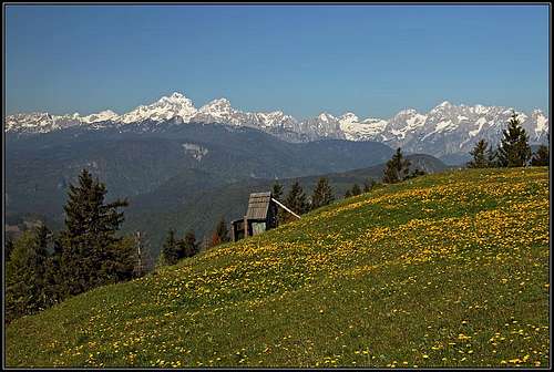
Spring on Zabreška planina (alpine meadow)
From the south (Slovenian side) Stol can be reached from Sava valley. Three roads lead us into its massif (they all reach the altitude of about 1100 m):
1. From Jesenice through the valley of Javornik creek.
2. From Žirovnica to Valvasor mountain hut.
3. From Žirovnica into Završnica valley.
From the north (Austrian side) you start the approach in Drava/Drau valley:
1. From Feistritz / Bistrica towards the south the Baerental / Medvedji dol valley goes. The road is closed for public traffic after Stouhuette (hut), on 1152 m.
2. The second north approach is from the main road Klagenfurt - Ljubljana, via Ljubelj Pass / Loiblpass. Approaching from the north, you turn before the border towards the west into Bodental / Poden, where the road ends on the altitude of 1050 m.
There is also a more remote approach from the east. From the southern portal of Ljubelj Pass tunnel (on the Slovenian side) you can walk to Zelenica (cable-car is not operating any more), 1536 m, and from there traverse the slopes of Vrtača to the Stol massif.
You can see the most detailed map above, and a traditional one on: http://www.austrianmap.at/. That's in German, but as of classical maps, you can refer to:
Karavanke, 1:20.000. Planinska zveza Slovenije, or
Karavanke, Central part and Grintovci, 1:50.000. Planinska zveza Slovenije.
For ski tours refer to:
1. Manfred Korbaj: Kaerntner Schitourenfuehrer. H. Weishaupt Verlag. Graz. 1992. (In German language)
2. M. Črnivec, C. Praček: Turni smuki. Planinska zveza Slovenije, 1984. (In Slovenian language)
Routes list
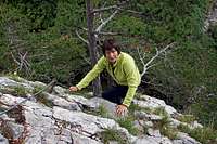
On the W ridge
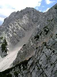
The north ravines from ferrata
This is the list of mountain paths and easier climbs, reaching the summit of Stol / Hochstuhl. Follow the links to the pages with more detailed descriptions or see the route descriptions on the map above.
1. From Valvasorjev dom (1171 m), 3 h, steep, but not difficult usual approach from the S. Marked walk up. We quickly gain altitude, nice views.
2. From Valvasorjev dom (1171 m) over Zabreška planina. A bit longer than #1, steep, but not difficult, marked walk up. 3 h 30 min.
From Dom Pristava (979 m) or Javornik Creek, 4-5 h, marked path, not difficult walk up. The variant over the border ridge is harder. See also the page of Vajnež!
4. From Klagenfurter Huette, 1663 m, over Belščica (saddle), 2 h 30 min (from Bodental 4 h 30 min), marked, partly steep, but not difficult walk up. The normal approach from the N.
5. From Završnica valley (1100 m), 3 h 30 min, not marked, partly steep, but not difficult walk up.
6. From Dom na Zelenici (1536 m), 3 h, marked, not difficult walk up. On a few places of the upper path below Vrtača helmet useful (falling stones).
7. From Klagenfurter Huette, 1663 m, over Široka Riža or more to the west Dolga Riža. Steep scree slopes, 2-3 h. Mainly used for descents.
8. From Klagenfurter Huette (1663 m), 2 h 30 min. There are four approaches, three were already mentioned under #4 and #7, and directly over the northern rocks of Stol goes a medium difficult ferrata.
9. Two steep couloirs which lead you from Klagenfurter Huette (1663 m) to the main crest east of the summit (not marked): Janežev žleb and Martin žleb.
10. From Poden valley (Bodental) over the Vrtača pass. Scree slopes, quite tedious walk-up. Not marked. 4 h. Rarely used in summer.
11. Orlice ridge (Stol NE ridge). From Belščica notch, 1840 m over the two peaks of Jelenčka / Edelweiss Spitzen, 1964 m, Celovška špica / Klagenfurter Spitze, 2105 m, and Krkotnik, 2116 m to the main summit. UIAA III (one detail), mostly UIAA II. 3 h 15 min.
Ski tours list
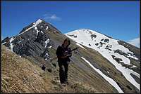
On a ski tour from the east - V Koznah basin

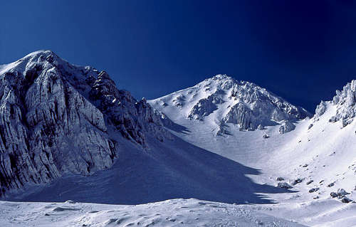
Near Klagenfurter Huette / Celovška koča
From the south:
1. From Valvasor hut (1171 m), on Stol/Hochstuhl by the ordinary south route. 3 h ascent, 1 h skiing. Steep, southern slopes.
2. Valvasor hut (1171 m), Prešernova koča (left ravine) - Stol. 3 h, 1 h skiing, very steep southern slopes.
3. Valvasor hut (1171 m), Prešernova koča (right ravine) - Stol. 3 h, 1 h skiing, very steep southern slopes.
From the east:
1. From Završnica valley - V Kožnah basin - Stol. 4 h, 1 h 30 min skiing. Moderately steep eastern slopes.
2. Završnica valley - East ravine - Prešernova koča - Stol. 4 h, 1 h 30 min skiing. Steep eastern slopes.
3. From Zelenica hut - V Kožnah basin - Stol. 4 h, 2 h skiing. Moderately steep eastern and north-eastern slopes. From Zelenica to Ljubelj there was an ordinary ski resort, but since winter 2013/14 cable car is not operating any more.
From the north:
1. From Klagenfurter Huette - Belščica Saddle - Stol. 4 h, 1 h 30 min skiing. Some a bit steep northern slopes.
2. From Bodental - Vrtača Saddle - Stol. 4 h, 1 h 30 min skiing. Steep north-eastern slopes.
3. From Klagenfurter Huette you can in good conditions ski over any of steep scree slopes on the northern face of Stol and Vajnež - very steep!
4. In addition from the north there are also some alpinistic possibilities, where the slopes (couloirs and ravines) are more steep as in "normal" ski tours. Janežev žleb, Martin žleb (not to the top), Central ravine (Osrednja grapa).
From the west:
1. From Javornik creek through Medji dol on Vajnež (2104 m). Ascent: 4 hours, skiing: 2 hours. Medium difficult. In good conditions the tour can be prolongued also to Stol (as a winter ascent, not skiing).
Vajnez/Weinasch
Vajnež is a distinct, from both, south and north side, quite respectful mountain. It is connected with Stol with a long ridge, which beyond Vajneževo sedlo (saddle) rises first on Potoški Stol and then continues to the main summit of Stol. Since 2011 it has on SP its own page.
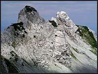
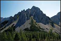
Celovska Spica / Klagenfurter Spitze
Klagenfurter Spitze / Celovška špica
The first summit NE of the main Stol summit is an undistinct Krkotnik / Marthaspitze, then comes the sharp Klagenfurter Spitze / Celovška špica, 2103 m. This one is most beautifully seen from the NE, from below Vrata pass. Towards the N it sends a 400 m high, steep wall, which is one of the most popular walls for harder climbing in Karavanke/Karawanken. The summit can be most easilly reached (scramble, easy climb) by the steep and on the upper part also exposed ridge, going up from the notch E of the summit. The notch can be reached from both sides, easier from the Slovenian than from the Austrian side.
Traversing the whole ridge from Belščica notch, 1840 m, to the summit of Stol is a nice climb, which already has some harder details (UIAA III, on the SW ridge of Klagenfurter Spitze / Celovška špica.
The three classical N face climbing routes are (from the west):
> Chimney Route (Kaminska smer, Kaminreihe). 350 m, UIAA III, 3 h 30 min. Beautiful and popular.
> Direct Route (Direktna smer, Direkte Route). 400 m, UIAA IV/III, 4 h.
> Horeschovsky (North) butress. 400 m, UIAA III/II, 3 h 30 min.
Jelencka / Edelweisspitzen
Jelencka/Edelweisspitzen
NE of Klagenfurter Spitze / Celovška špica the main ridge goes over two sharp peaks, both 1964 m, which are itself not important, but when treversing the whole ridge they offer a nice, easy, but quite exposed climb (UIAA II). From the rest of the ridge they are separated with Celovška škrbina / Klagenfurter Scharte (notch), 1924 m, on the SW and Belščica notch, 1840 m, on the NE. Both notches are easilly accessible from both sides.
Svacica
On the summit ridge of Svačica
The NE cornerstone of Stol massif is a triangular summit of Svačica, 1953 m. Here the main summit of Karawanks turns from the NE direction to the E direction, continuing to Vrtača massif. Svačica is separated from the rest of Stol's NE ridge with Belščica notch, 1840 m, from Vrtača massif with Vrtača saddle, 1845 m and from Kozjak / Geissberg summit with Vrata / Matschacher Saddle, 1714 m. The SE side of the summit is not steep, covered with grass and dwarf-pine and offers the easiest ascent (the summit ridge is a bit exposed). In winter and spring this slope is the natural highest point of the ski tour (till the fore-summit). The N ridge is rocky, consisting of many towers. But through the ravine right of it, from Vrata pass, also an easy climb (UIAA I) goes.
 Svačica from the S |
 Svačica from the N-NW |
Red Tape
No limitations.
When To Climb
Stol/Hochstuhl can be climbed any time of a seson. When slopes are icy or covered with high snow, the ascent can be dangerous and the complete winter equipment is needed.
Weather: Click the sticker below!
Mountain huts
Mountain huts, convenient for Stol ascent and their approaches are:
- Valvasorjev dom, 1171 m, parking place.
- Prešernova koča, 2172 m, 15 minutes below the summit of Stol, 2 h 30 min from Valvasorjev dom.
- Dom Pristava, 979 m, parking place.
- Dom na Zelenici, 1536 m. Cable-car not operating any more. From the road 1 h 30 min.
- Stouhuette, 960 m, parking place.
- Klagenfurter Huette, 1663 m, 2 hours from Stouhuette, a little less from the parking place.
- Bodental private pension, 1050 m, parking place.
A few general facts for tourists and about camping you can find here (Slovenia) and here (Austria).