Page Type Page Type: Area/Range
Location Lat/Lon: 47.01672°N / 12.31951°E
Additional Information Elevation: 12015 ft / 3662 m
Sign the Climber's Log

Overview

geographical classification: Eastern Alps > Hohe Tauern > Venediger Group

The Venediger Group is the northwestern and one of the most important and interesting parts of the Hohe Tauern. Grossvenediger itself is in the very center of it's group and long ridges spread wide out to all sides that include many more interesting mountains, although they are not of equal height. At the main ridge where the sub-ridges end there are glaciers of still remarkable size so this area is perhaps the most "arctic" region of the eastern alps, together with the Oetztal Alps.
Venediger Group panorama seen...central Venediger Group seen from east

From all sides pittoresque valleys lead from the villages to the mountains. There are many mountain cabins related by hiking trails, especially on the south side. So you can walk from hut to hut about a week or longer and need not to descend into civilization. Because of these advantages and the great scenery the area is very popular and you cannot expect lonelyness.

In the spring season there are great possiblities for ski mountaineering. The traverse of the whole group and further on towards the Grossglockner - called "Ski Route Hoch-Tirol" has become very popular in recent years and is often compared with the famous "Haute Route" between Chamonix and Zermatt. The Essener-Rostocker Huette mountain hut is in the center of one of the best areas for ski mountaineering and the Kuersinger hut can also be highly recommended.

There are no cablecars or pay roads in the whole mountain group which is mainly part of the National Park "Hohe Tauern". So here you can find pure high mountains at their best, more than anywhere else in Austria.
To fullfill the picture it must be said that it is a paradise for independent and experienced climbers but there are no popular climbs in higher grades of difficulty neither in ice nor in rocks.

Getting There

The Venediger Group builds the northwestern part of the Hohe Tauern. Politically it belongs mainly to Austria (northern part to the province of Salzburg, southern part to the province of eastern Tyrol), only the SW edge belongs to the italian province of Alto Adige/South Tyrol.
Getting there depends on in which valley you want to start your activities.
For the main roads:


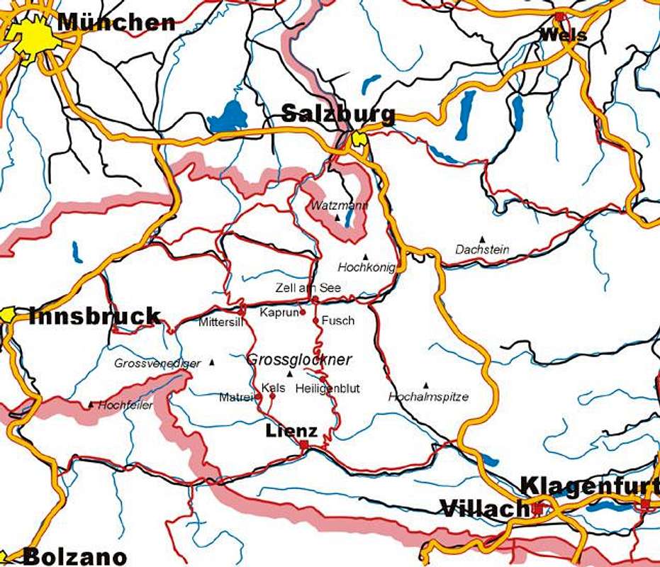
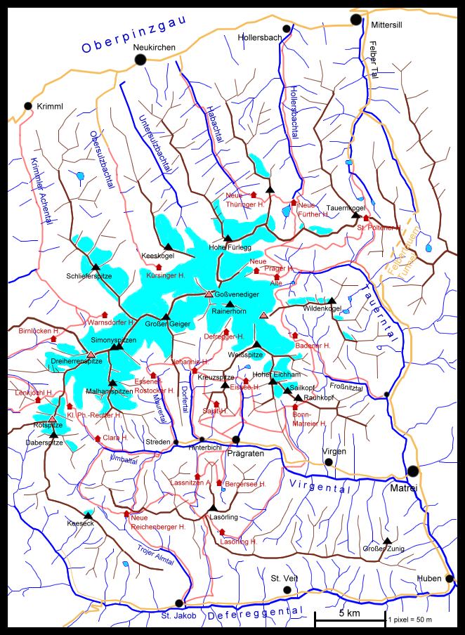
For details please refer to the following maps:

GrossvenedigerRoetspitze Dreiherrenspitze Kristallwand
selfmade interactive map of Venediger Group. The red summit symbols are linked to their pages

The south western part is shown on the following map:


For the geographical location of this group page I choose the big parking at Streden at the end of the virgental valley, that is the most important trailhead of the group.

main mountains

Each ot the following mountains would deserve a page on SP! And of course there are even more mountains, that are not on this list. So if you have the knowledge you are invited to contribute.

Berg-Tabelle
Name Height
Description Starting Point for normal route/s
Grossvenediger
3662m
Called the "monarch" Defreggerhaus
Neue Prager hut
Kuersinger hut
Badener hut
Rainerhorn 3560m
Neighbor peak of the Grossvenediger, can be collected on it's south east route Defreggerhaus
Badener hut
Dreiherrenspitze 3499m
important landmark - Here the three regions of Salzburg, eastern tyrol(Austria) and south tyrol (Italy) meet. 2nd most mportant mountain ofthe group
Essener-Rostocker hut
Lenkjoechl hut
Birnluecken hut
Roetspitze 3495m
probably the nicest mountain of the group with a recommendable ascent with rock (UIAA II) and ice (40°) along the north ridge Lenkjoechl hut
Kleine Philipp-Reutter hut
Clara hut
Simony-Spitzen 3488m,
3440m
Two glacier peaks related by a sharp rocky ridge (UIAA III). The traverse is one of the most classical climbs of the group Essener-Rostocker hut
Daberspitze 3401m
Neighbor of the Roetspitze. The loneliest high mountain of the group with very softrocks. Needs experience.
Neue Reichenberger hut
Malham-Spitzen 3373m,
3364m
3329m
Connected peaks between the Maurertal valley and the Umbaltal valley. The "Mittlere Malhamspitze" is the easiest skiroute from the hut Essener-Rostocker hut
Kleine Philipp-Reutter hut
Hoher Eichham 3371m Sharp rocky mountain above the Virgental valley, UIAA III (short), II Bonn-Matreier hut
Grosser Geiger 3360m One of the most popular climbs in summer and spring, fairly easy Essener-Rostocker hut
Kuersinger hut
Kristallwand
3329m
house summit of Badener hut at the beginning of the big glacier plain
Badener hut
Defreggerhaus
Johannis hut
Weiss-Spitze 3300m At the end of the Timmeltal valley and the beginning of the great glacier plain;
Eissee hut
Keeskogel 3291m "house summit", can be climbed shortly to gain an overview Kuersinger hut
Schlieferspitze 3289m Main mountain of the ridge between Krimmler Achental valley and Obersulzbachtal valley. One of the best ski downhills in spring Warnsdorfer hut (summer)
Kuersinger hut (spring)
Hohe Fuerlegg 3244m Interesting glacier mountain and the end of the Habachtal valley, not very often climbed NeueThueringer hut
Sail-Kopf (Saeul-Spitze) 3209m Highest hiking mountain of the group, has to be crossed to climb the Hoher Eichham Bonn-Matreier hut
Keeseck 3173m Highest mountain of the Panargenamm ridge between the Virgental valley and the Defereggental valley St. Jakob in Defereggen valley
Kreuz-Spitze 3164m House summit with a marked route but steep Sajat hut
Lasoerling 3098m Hiking mountain south of the Virgental valley, best viewpoint south of Grossvenediger
Lasörling hut
Rauh-Kopf 3070m Marked house summit Bonn-Matreier hut
Grosser Moosstock 3059m Hiking mountain at the very SW-end of the mountaingroup above the Tauferer Tal valley in south Tyrol. "Training mountain"for famous climber Hans Kammerlander Ahornach
Larmkogel 3022m Hiking mountain between the Habachtal valley and the Hollersbachtal valley NeueThueringer hut
Neue Fuerther hut
Wildenkogel 3022m Hiking mountain. The best viewpoint for Grossvenediger east side. Badener hut
Matreier Tauernhaus
Tauernkogel 2989m "guard" at the historic trade route over the Felbertauern pass, marked but steep hiking mountain St.Poeltener hut
Grosser Zunig 2771m Hiking mountain directly above the town Matrei Matrei


huts

This tableboard shall give a rough overview about the possibilities of hiking and climbing from the basis of a hut. The named traverses to other huts can all be done without glacier gear. I presume that if you have to ability to walk on glaciers you will climb mountains in addition. The table says nothing about difficulty of hikes and climbs!

here is a description in english of the "Venediger Hoehenweg" hiking trail. For hikers this is the best possiblility to get to know the beauty of this area.

Name

Name

Height

Hours of ascent to the hut from

Traverse to huts in hours

Mountains to climb in hours

Alte Prager Huette currently closed!!

2489 m

Innergschloess 3

Badener 4

St. Poeltener 6

Neue Fuerther 5


Badener Huette

2608 m

Gruben 5

Bonn-Matreier 5

Alte Prager 4

Grossvenediger 6

Bergersee Huette

homepage

2182 m

Praegraten 2,5

Lassnitzen 1,5

Lasoerling 3

Birnluecken-Huette

2441 m

Prettau 2,5

Warnsdorfer 4

Dreiherrenspitze 5

Bonn-Matreier Huette

2750 m

Virgen 4

Eissee 3

Badener 3,5

Hoher Eichham 4

Sailkopf 1,5

Rauhkopf 1

Clara-Huette

2038 m

Streden 3

Neue Reichenberger 5h

Lenkjoechl 5

Roetspitze 5

Daberspitze 7

Dreiherrenspitze 6

Defregger Haus

2962 m

Johannishuette 2


Grossvenediger 3

Eissee-Huette

2520 m

Praegraten 4

Bonn-Matreier 3

Sajat 2

Johannis 3

Weissspitze 3

Essener-Rostocker Huette

2208 m

Streden 2,5

Johannis 3,5


Johannishuette

2121 m

Hinterbichl 2,5 (Taxi: 0)

Defregger 2

Essener-Rostocker 4

Sajat 3

Eissee 3,5


Kleine Philipp-Reutter Huette (bivouac hut)

2692 m

Clara Huette 2,5

Lenkjoechl 2,5

Roetspitze 3

Dreiherrenspitze 4

Malhamspitzen 4

Kuersinger Huette

homepage

2558 m

Hopffeldboden 6 (Taxi 3)


Grossvenediger 5

Keeskogel 3

Grosser Geiger 5

Schlieferspitze 5

Lasoerling Huette

2350 m

Virgen 4

Neue Reichenberger 6

Lassnitzen 3

Lasoerling 2,5

Lassnitzen Alm

1887 m

Praegraten 1,5

Neue Reichenberger 5

Bergersee 2


Lenkjoechl-Huette

2603 m

Kasern 3,5

Clara 4,5

Roetspitze 3,5

Dreiherrenspitz 5

Neue Fuerther Huette

2201 m

Hollersbach 6

Neue Thueringer 3,5

Alte Prager 6

Larmkogel 3

Neue Prager Huette

2796 m

Alte Prager 1


Grossvenediger 3,5

Neue Reichenberger Huette

2586 m

St. Jakob 3,5

Streden 3,5

Clara 3,5

Lasoerling 6

Keeseck 3

Neue Thueringer Huette

2240 m

Habachklause 5,5

Fuerther 3

Alte Prager 5

Larmkogel 2

Hohe Fuerlegg 5

Sajat-Huette

2530 m

Praegraten 4

Johannis 2,5

Eissee 2

Kreuz-Spitze 2.5

St. Poeltener Huette

2481 m

Matreier Tauernhaus 3

Alter Prager 6

Tauernkogel 1,5

Warnsdorfer Huette

2336 m

Krimml 6 (with Taxi 2)

Birnluecken 4

Schlieferspitze 4

Grosser Geiger 6


Red Tape

no limitations of alpine activity, though most of the group is part of the national park

When To Climb

Most huts are guided from July to September for the summer season. The traverse hikes from hut to hut can be done normally at least from mid July to mid September (depends on snow conditions). Climbing glacier mountains can be more difficult in later summer (from August) because of pure ice instead of snow and the risk of stonefalls.
Spring season for Ski mountaineers is from March to May

Mountain Conditions / webcam

Basically it can be said that the weather is more stable in the southern half of the group. Most rain or snow comes from NW direction and covers the northern half. But if there is a depression over Italy (esp. at the gulf of Genova) it is vice versa!
You can get personal advice about weather conditions on the phone every afternoon from the weather service of Innsbruck, Nr. 0043-(0)512-291600. I hope these guys can speak english (the chief, Karl Gabl, surely can)

"Muhscam" is a webcam view of the whole south side of central Venediger Group a s seen form the great viewpoint "Muhsberg" north of Lasoerling

maps and books

maps:
best map is Alpenvereinskarte (Map of the german/austrian alpine club) 1:25.000 Nr. 36 Venedigergruppe, available at DAV lifeAlpin

To view and/or print maps for mountaineering in Austria see www.austrianmap.at
(for Browsers Version 4 and above)

guide book of the german alpine club (in german) will come out soon

External Links

  • long hiking routes in eastern Tyrol
    english descriptions on www.osttirol-tourismus.at, including "Venediger Hoehenweg"a nd "Lasoerling Hoehenweg" which are both in the Venediger Group
  • Bergtour Großvenediger
    via-ferrata.de - Klettersteig Portal. Under "Sonst. Touren" are lots of fotos of our tour on the third highest peak of austria, the Großvenediger (3674m).
  • www.hinterbichl.at
    very detailed website (in german) about hiking and climbing possibilities around the Virgental valley
  • Austrian Map online
    Online digital maps of Austria (OEK 50, OEK 200 and OEK 500) by the BEV (Bundesamt für Eich- und Vermessungswesen) - in German


Parents 

Parents

Parents refers to a larger category under which an object falls. For example, theAconcagua mountain page has the 'Aconcagua Group' and the 'Seven Summits' asparents and is a parent itself to many routes, photos, and Trip Reports.

Hohe Tauern GROUPAreas & Ranges