
-
 66670 Hits
-
 95.97% Score
-
 56 Votes
|
|
Mountain/Rock |
|---|---|
|
|
48.70400°N / 113.7344°W |
|
|
Hiking, Mountaineering, Scrambling |
|
|
Spring, Summer, Fall |
|
|
8180 ft / 2493 m |
|
|
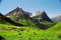
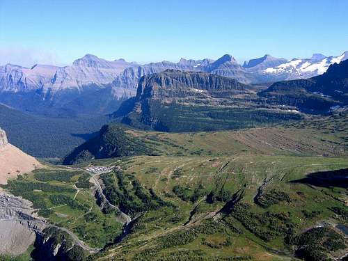
Overview
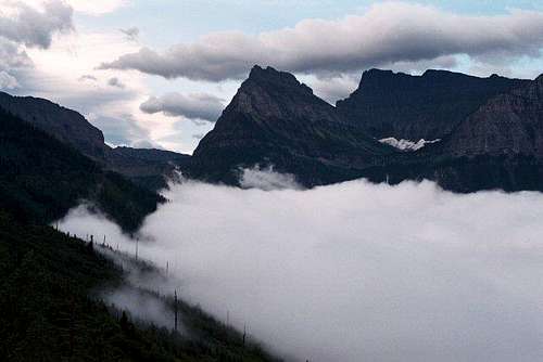
Early morning drive above the clouds, Oberlin in center

Just mellow, no drama...
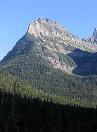
Mount Oberlin, from the Sun Road

A nice summit
Mount Oberlin is a "friendly" Glacier National Park peak. Easily accessed, easily climbed—along with Divide Mountain, probably one of the two easiest ascents in the park—yet with a grand view from the top, it makes an ideal introduction to GNP mountains. The climb is readily-enough done in half a day (actually, less), making for a good "light" day between more strenuous outings, or it can be done when inclement weather prohibits lengthy exposure to the elements during longer days on the more difficult peaks. Climbing in Glacier can be intimidating, and is often not at all the same as the rest of the Rocky Mountains, which makes this mountain a good, non-stressful, introduction to first time visitors. The Clements Saddle Route (see below) is a fun climb, and the view is quite special; more than well worth the effort!
 Oberlin, from GTTS Road Oberlin, from GTTS Road |
 Moody summit Moody summit |
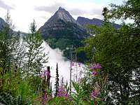
 Mt. Oberlin, Cannon Mtn Mt. Oberlin, Cannon Mtn |
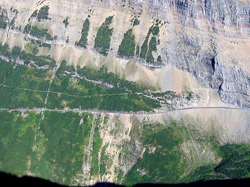
The mountain was named by Dr. Lyman B. Sperry of Oberlin College, Ohio. Dr. Sperry, known as the "Gentleman Explorer," in 1896 led the first party to reach the glacier that bears his name today, and later oversaw the building of the trail (pretty much the same as the trail in use today) providing access to Sperry Glacier. An interesting sidenote is that the waterfall we know as Birdwoman Falls, tumbling 460' down the north side of the Mount Oberlin massif, and a popular tourist stop along the western approach to Logan Pass, was originally called "Oberlin Falls."
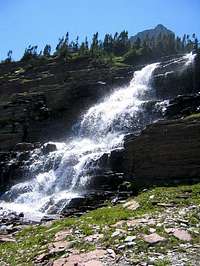 Falls in the Hanging Garden Falls in the Hanging Garden |
 Approaching the summit Approaching the summit |
 Well okay, sometimes conditionsare not all that great Well okay, sometimes conditionsare not all that great |
Photographic Fun from the Summit
 Pollack, Siyeh, Piegan, WALL...
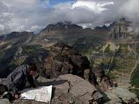
An airy summit

Reynolds Mountain
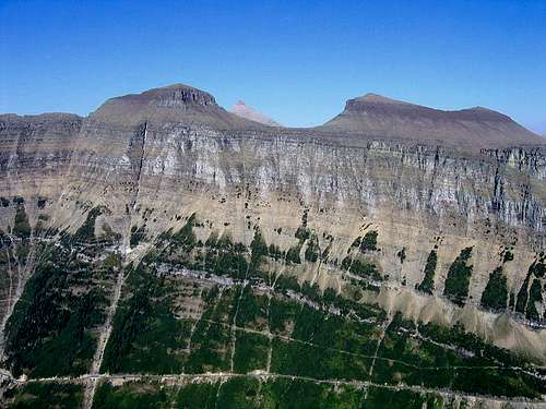
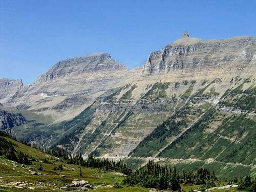
It's mostly the glacier's fault, you know: the sudden precipitous faces of the mountains in this area, the end result of a ready-made circumstance of sedimentary and rotten rock, ripe for the taking...so the glaciers did indeed come, had their way, and after several ice ages left us with walls, and no foothills to deal with, and lots of air beneath the feet. Nice stuff to look at. Thrilling to climb. Sometimes the views are a mountain paradise, running-seemingly-into-forever spectacular, with other times vision being blocked by...walls. Walls not hemming one in. Magnificent, thrilling, vision-interrupting, vertically tilted remnants of what great ice can do with time and upthrust!
 When sitting on the summit confronted by this, you don't want to ever leave!

Mount Cannon
Mount Oberlin is the easiest entry into this vision-curtailing, mind expanding edition of paradise of which I know. Take the jaunt from the visitor center to its summit, and—oh yes!—the vista unfolds in almost every direction. Almost, that is...but not to the east. That way, directly before you and blocking sight of the jumble beyond, is the western flank of Pollock Mountain. It is the southern end of the Garden Wall, and easy vision moves a bit north to Bishops Cap, Mount Gould, and points beyond, then returns, back to what this section is all about (easily rationalized as "goofing off with camera"), and it is unavoidable, you couldn't miss it if you tried. Directly before you, blocking any attempts to see points east, is a most impressive and imaginative wall of rock.
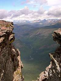
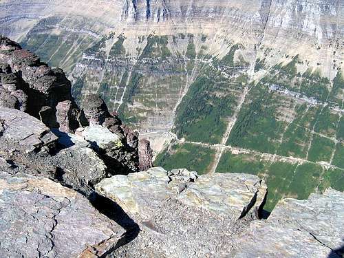 Many words describe this place. "Depth" is one of the best.

Clements Mountain
Some of these photos really don't have much to do with climbing, but the late afternoon sun illuminated the landscape in such a manner, and the walls in GNP are so all-pervasive, that I thought it might be of interest to throw out something a bit photographically unusual, the idea being to show a different perspective on what I like to think of as the magnificent common-place existing everywhere in these mountains. But then on the other hand, if you think about it, attaining the heights brings an expanded perspective on what glacial carving does to mountain flanks. Put it that way and these photos actually have a great deal to do with climbing.
 From Oberlin's flank, the view sliding north encompasses Bishops Cap, Mount Gould...
 Mount Gould in the distance Mount Gould in the distance |
 Northern end of the Garden Wall, portionsof the Livingston and Lewis Ranges Northern end of the Garden Wall, portionsof the Livingston and Lewis Ranges |
Getting There (and two of Logan Pass)
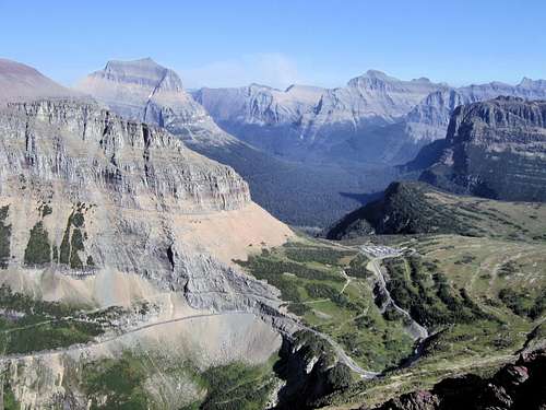 Logan Pass summit from Mount Oberlin: High point of Going-to-the-Sun Road
There aren't very many, if any, mountains as spectacularly-enjoyably-easy-to-reach as Oberlin (it's a nice drive!). Simply put, it is located at the summit of Logan Pass, the high point of Going-to-the-Sun Road, which is the one and only road running entirely through Glacier National Park. Western terminus is at West Glacier; eastern terminus is Saint Mary.
These two towns are on all the maps, as is the road through the park. And as is the park. For much of the distance of the Sun Road there are length and width restrictions on vehicles; they cannot be over 21 feet long and over 8 feet wide. If that creates a problem for you, there is the distinct possibility you are climbing in the wrong mountains.
Check under "Camping," for a link on current campground information; also, the links immediately below will provide a variety of information.
Map of Waterton/Glacier International Peace Park
(Note that clicking on the image after it loads brings up a larger version, making it MUCH easier to read.)
This Link will direct you to pertinent and current road information. Weather permitting, the Park Service traditionally begins plowing the Sun Road the first Monday in April. It is a long, difficult, dangerous undertaking getting from that tenuous start to opening day!
 Logan Pass, this view angling a little more south
Clements Saddle Route

First the snow, then the color...
Note that a very detailed description of this route also appears in CLIMB GLACIER NATIONAL PARK Volume 1
Park at the Visitor's Center, go to the ranger desk and register your climb of Mount Oberlin. You will be briefed on the current status of the route to the mountain. In an effort to protect the fragile tundra of the Hanging Gardens atop Logan Pass, the standard route to Oberlin from the Visitor's Center has been rerouted. New cairns have been put down, in an attempt to control the "herd" mentality of simply making a beeline for the summit with a quick charge across the tundra. By registering, you'll have access to the latest changes that have been made. To repeat: The tundra has taken a beating; it is important to check in at the ranger station so as to obtain the most current route information!
NPS PDF file with maps and descriptions of Logan Pass access routes
ROUTE

Self-explanatory... (Readable when enlarged)
From the registration desk, go up the stairs and out the north door and follow the cement walkway north for about 100 feet. Just before the walkway switches back toward the visitor center you'll see a very well worn trail on your left. There is no identifying sign marking this as the trailhead, but step over the chain—you're not breaking any rules by doing so—and follow this trail through the lower levels of the spectacular Hanging Gardens. You'll soon cross a stream, but stay on the trail (not a problem; it's quite obvious) until coming to a sign requesting hikers to stay on the cairned trail, and not just barge cross the tundra.
When I first climbed Oberlin in the fall of 2004 this trail was in the beginning stages of being marked, and there were a few places where it would have been possible to leave the route by mistake. Not so now (summer of 2006); the trail is VERY good and VERY well marked with cairns, basically, all the way to the summit. The priority trail, and the one the NPS is trying to get folks to use, heads for the saddle between Clements and Oberlin, and from the saddle follows the ridge up towards the summit.
Reaching the saddle requires some easy scrambling. At the saddle, you're in a position to ascend the South Ridge route (Edwards—A Climber's Guide to Glacier National Park; if you don't have this book and plan on climbing in Glacier...GET IT—calls this the Clements Saddle Route, and describes it as "Class 3, with possibly one class 4 pitch"—it is the more interesting ascent). At this point, where you go is, if not always perfectly obvious, pretty much intuitive; just use patience in picking your way through the cliffs:

The proper route is marked!
Even the cliff portion of this short, introductory GNP climb is now well-cairned, and to be honest, it is probably a good thing, as the cliffs, while certainly in no way difficult, present enough of an obstacle they have to be treated with respect—especially by those having no experience with this type of terrain—and the route does meander through them. The key word, as mentioned above, is "patience," but I find this sort of cliff work to be quite enjoyable, and like I've already said, they're not really difficult—plus to those having no experience in the particular challenges presented by rock climbing, are a good introductory first step.
Once you are past the cliffs and reach the summit ridge, scramble north to the exciting and airy summit. Total ascent should not take more than an hour-and-a-half at most, and probably that long only if you take lots of pictures, or have a picnic.

An obvious route—but don't use it!
Shortly after passing the sign mentioned above you'll see another trail, which makes a beeline for the scree-covered slopes encompassing the southern basin of the mountain. Over the years this trail has become quite worn and eroded because it has been used repeatedly for rapid descents off the mountain, and the NPS is trying to discourage its use. You won't want to take it on the way up because, simply, who wishes to scramble up scree when the alternative is a firm ridge walk, and some nice cliffs?! The ridge/cliffs route is just as fast, anyway, and while the ranger I spoke with said they're not enforcing non-use of the "scree" route, they really wish people would just retrace their steps on the way down. Admittedly, the scree would be a bit faster, but jeez, it's not much over an hour anyway...so people, don't contribute to the erosion in the center of the basin: make use of the ridge and cliffs. Both ways!
ESSENTIAL GEAR
In summer and fall, standard day hike gear will do.
In snow and ice conditions, ice axe and crampons are required.
![Logan Pass Cairn Inspectors...]()
Logan Pass cairn inspectors...
No permits required, but you must pay a park entry fee, which is $25 for one week, or $35 for an annual pass. Registration for day climbs in Glacier National Park is recommended, but not mandatory. Probably anyone prone to
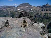
![This totally adorable Marmot...]()
Definitely not a face to trust!
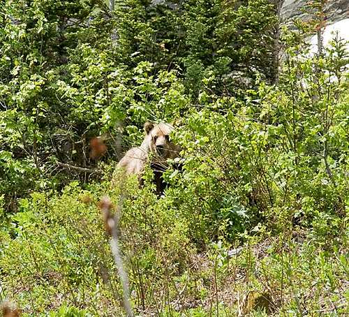
climbing in this part of the country already knows this, but the Northern Rockies are full of wildlife. Always be aware, and don't do anything stupid, like—for example—feed the bears, think that a mountain lion is even remotely related to your pet cat, or run up to a moose (moose are quite unpredictable, irritable, and very dangerous). And never, ever, EVER forget you're in grizzly country; they insist on being left alone—disagreement on that point is not an argument you'll win! Bear spray and noise should be part of every GNP foray you make into the back country. Black bears will be found in the forests, grizzlies commonly venture onto the above-timberline tundra, sometimes, when in pursuit of such delicacies as ladybugs or cutworm moth larva, even to the peaks! Also note that improperly stored food in park campgrounds (i.e., scraps left around the table or campfire, or edibles in your tent rather than your car) will subject you to a $50 fine (it should be more, but that's just my opinion). If you wander off, leaving your pack unattended, and there is food in it which attracts the attention of, for example, a bear, it is also a fine. Folks, the Park Service is serious about not providing human food access to the critters!
The mountain is not accessible in winter, but if winter conditions exist after the road opening, and snowpack is still considerable, an ascent is not recommended due to likely avalanche activity. Yet another reason to register, and check in, at the Visitor Center's Ranger desk.
Click here for General Camping Information, and click here for Current Site Availability in specific campgrounds.
There is also a great deal in the way of accomodations and camping on the Blackfeet Indian Reservation, which includes the towns of Saint Mary, Browning, Babb, and East Glacier Park.
Lastly, and for those inclined towards more lengthy outings...GNP does have Backcountry Campsites throughout the park. Some of these sites can be reserved; others are on a first come basis. Anyone doing extensive, several day, remote hiking/climbing would be well advised to check this out.
Weather page—an overview, plus current conditions and forecast
This is the New NPS Web Cam Page.
Vernon was an important contributor on SummitPost, but beyond merely making good, informative pages, he actually inspired many who read his work. No one put more work into his or her pages than Vernon did, and many of those pages, especially those related to Glacier National Park, the place he loved above all others, are works of art in both the writing and layout. More than one person has wanted to visit Glacier or go back to Glacier largely due to what he shared about that magnificent place.
Many people on SP counted Vernon among their friends, and many more saw him as one of the best, one of those who exemplified the spirit of this site. He was one of the best of us, he will be missed, and he will not be forgotten.
As a tribute to him, Vernon's pages will remain in his name. Any member who sees a need for an addition or correction should please contact site management via the "Send PM to the Elves" feature.
Rest well and climb on, Vernon.
In summer and fall, standard day hike gear will do.
In snow and ice conditions, ice axe and crampons are required.
The Red Tape, Wildlife, & Cautions Section
 |
 |
|---|

Logan Pass cairn inspectors...
Definitely not a face to trust!
When To Climb, & Climbing Considerations
Average opening of Going-to-the-Sun Road is mid June. It has been as late as into July, or—rarely—as early as mid May (earliest opening ever was May 16, 1987; second earliest was May 22, 2005). Normal climbing season would commence soon after the road opens, although be aware that there will still almost always be a great deal of snow in the higher elevations—ice axe, crampons, and snowshoes make good friends!—and normally continue through September, although weather in Glacier changes dramatically usually around the end of August. As with any mountain environment conditions vary greatly from year to year, so the key here is to check road/snowpack conditions, and PAY ATTENTION to the weather.The mountain is not accessible in winter, but if winter conditions exist after the road opening, and snowpack is still considerable, an ascent is not recommended due to likely avalanche activity. Yet another reason to register, and check in, at the Visitor Center's Ranger desk.
CLIMBING CONSIDERATIONS
Because of the nature of the rock, there are special considerations regarding climbing in Glacier National Park, and grading systems unique to the Park have been developed by both J. Gordon Edwards and the Glacier Mountaineering Society. Anyone doing more than just "trail" hiking in this part of the Rockies should read the excellent and important information put together by Fred and Moni Spicker. Much—if not most—of the rock in GNP is sedimentary and rotten, and you need to know about it: Glacier National Park Rock & Grading Systems.
Camping
There is no camping on Logan Pass. There are numerous campgrounds available within Glacier National Park, of which only Fish Creek and Saint Mary take reservations (not required, but probably a good idea during the peak summer tourist period, especially on weekends). There are also many campgrounds—USFS, KOA, and privately-owned commercial—as well as motels, just outside the park on both the west and east sides. Lodging, whether camping or indoors, should be no problem.Click here for General Camping Information, and click here for Current Site Availability in specific campgrounds.
There is also a great deal in the way of accomodations and camping on the Blackfeet Indian Reservation, which includes the towns of Saint Mary, Browning, Babb, and East Glacier Park.
Lastly, and for those inclined towards more lengthy outings...GNP does have Backcountry Campsites throughout the park. Some of these sites can be reserved; others are on a first come basis. Anyone doing extensive, several day, remote hiking/climbing would be well advised to check this out.
Current Park Conditions/Web Cams
Weather page—an overview, plus current conditions and forecast
This is the New NPS Web Cam Page.
External Links/Additional Information/Items of Related Interest
- Non-Park Service Information Link (Worth checking out!)
- Glacier National Park Chat—a great source for friendly conversation
and information concerning all things GNP related!
In Tribute
On March 1, 2011, Vernon Garner, Saintgrizzly, left us after losing a bold, inspiring fight against pancreatic cancer. Or maybe he won, for he is at last free of his pain and has "shuffle[d] off this mortal coil."Vernon was an important contributor on SummitPost, but beyond merely making good, informative pages, he actually inspired many who read his work. No one put more work into his or her pages than Vernon did, and many of those pages, especially those related to Glacier National Park, the place he loved above all others, are works of art in both the writing and layout. More than one person has wanted to visit Glacier or go back to Glacier largely due to what he shared about that magnificent place.
Many people on SP counted Vernon among their friends, and many more saw him as one of the best, one of those who exemplified the spirit of this site. He was one of the best of us, he will be missed, and he will not be forgotten.
As a tribute to him, Vernon's pages will remain in his name. Any member who sees a need for an addition or correction should please contact site management via the "Send PM to the Elves" feature.
Rest well and climb on, Vernon.