
-
 141019 Hits
-
 95.61% Score
-
 54 Votes
|
|
Mountain/Rock |
|---|---|
|
|
48.51161°N / 121.05782°W |
|
|
Download GPX » View Route on Map |
|
|
Skagit |
|
|
Hiking, Mountaineering, Trad Climbing, Scrambling |
|
|
Summer, Fall |
|
|
8815 ft / 2687 m |
|
|
Overview

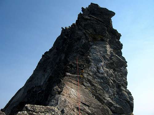
Excited on the Summit
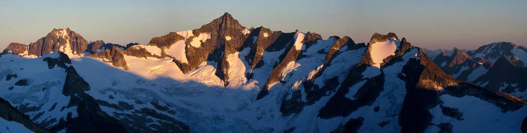
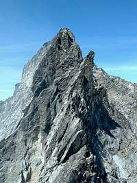
Forbidden Peak is one of a kind and is tucked away from view in the Cascade Valley. It's listed on the Washington Top 100, located in the North Cascades National Park, and is on Washington's 100 steepest list.
The peak has been likened to a "great obelisk of rock", a classic horn created by the merging of several glacial cirques. Three remarkable ridges radiate from the summit (N, W, and E), Alpine Grade II-III and 5.2-5.8 (depending upon route and which guide you survey). The icefield and valley views, the alpine approches, the rock quality, the shear majesty and position of the peak combine to make this a memorable and magnificent ascent by any route. Fred Beckey has a great account of the first ascent in a chapter of his Challenge of the North Cascades... and comments in his guide that the mountain was formerly referred to as both Mt Forgotten and Isosceles Peak (since the summit pyramid looks triangular from almost all vantage points above the tree line except when foreshortened from close beneath Boston Basin or Boston Glacier, etc.) before his first ascent party made the "Forbidden" name stick in the early 1940s.
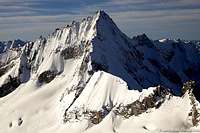
The West Ridge receives the most attention due to its inclusion in the 50 Classic Climbs in North America. The attention is well-deserved, but don't expect to spend a lonely day on the route. The North Ridge is much more alpine and committing while the East Ridge Routes are much more technical (5.7-5.8 on the Direct Ridge) or loose and unsavory (NE Ledge AKA Northeast Face had a fatal fall on traverse in 1975). The warm south face is gnerally downslabbed and holds a number of serious alpine rock climbs 8-10 pitches Grade III-IV / up to 5.10-A3. Selected Climbs in the Cascades writes "There is no easy way off Forbidden Peak." It's true. Many of us have felt that sense of uneasiness on the summit of Forbidden that goes with having completed only half the climb... Reference material from Beckey Guide Vol 2 and Selected Climbs in the Cascades by Potterfield and Nelson.
 Forbidden Peak West Face from Klawatti Camp : Photo Taken by Matt Lemke
 The Big Air Step The Big Air Step |
 One of the Cruxes One of the Cruxes |
 West Ridge Climb West Ridge Climb |
 East Ridge Direct East Ridge Direct |
 South Face South Face |
 Rappelling down the West Ridge Rappelling down the West Ridge |
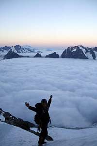 Excited for the Climb above the Clouds Excited for the Climb above the Clouds |
 Climbing on the Upper North Ridge Climbing on the Upper North Ridge |
 Cascade Valley below during Sunset Cascade Valley below during Sunset |
 Eldorado Peak with Moraine Lake Eldorado Peak with Moraine Lake |
Getting There
View Easy Directions from google maps to get exact directions from your location.
Getting there from Seattle: Drive North on I-5 until you get to Arlington which you take a right at exit 208 onto highway 530. The highway briefly takes a left in down town Arlington onto highway 9 which a few seconds later be sure to turn right back onto highway 530 east to Darrington. At Darrington where the road pretty much ends you take a left onto highway 530 which goes north. In about 19 miles the highway ends, take a right onto highway 20 towards Marblemount. In about 7.5 you arrive at the city of Marblemount. After passing a few gas stations the highway curves, be sure to go strait which goes onto the Cascade River Road. This road takes you all the way to the "trailhead" of Forbidden Peak just past mile marker 22. Keep in mind that the last 10 miles is gravel road and washes out almost every year at some point. The trailhead is on the left side of the road (when heading up) and is a pull out just before the Cascade Pass trailhead.

Getting there from Seattle: Drive North on I-5 until you get to Arlington which you take a right at exit 208 onto highway 530. The highway briefly takes a left in down town Arlington onto highway 9 which a few seconds later be sure to turn right back onto highway 530 east to Darrington. At Darrington where the road pretty much ends you take a left onto highway 530 which goes north. In about 19 miles the highway ends, take a right onto highway 20 towards Marblemount. In about 7.5 you arrive at the city of Marblemount. After passing a few gas stations the highway curves, be sure to go strait which goes onto the Cascade River Road. This road takes you all the way to the "trailhead" of Forbidden Peak just past mile marker 22. Keep in mind that the last 10 miles is gravel road and washes out almost every year at some point. The trailhead is on the left side of the road (when heading up) and is a pull out just before the Cascade Pass trailhead.
Routes

West Ridge in Winter
North Side of the TF Traverse
North Ridge from a Plane

East Ridge Direct Crux

Traversing the East Ledges

Northwest Face
(Authors Note: I've only done the West Ridge on this mountain. So for the sake of accuracy I carefully quoted various pages on SP with the proper credits given to the authors)
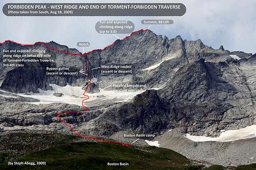
West Ridge (5.4): This is the most popular route on the mountain and is listed on the 50 Classics of North America. This is by far one of the best routes I have ever done and would recommend it to alpine enthusiasts. Some say this route is 5.6 while others say it's 5.2. I'd say it's fair to say this is 5.4... if it is 5.6, it's short and sweet. A lot of this route on the upper mountain is enjoyable class 4. This route can be done as a long day or a enjoyable overnight trip. There are plenty of rappel slings so getting off this mountain shouldn't be too bad (I counted 8 rappels). Rock shoes are not required but they certainly were nice to have. The glacier above Boston Basin is shrinking at a rapid rate to the point where I don't even think glacier gear is required considering that the so called "crevasses" are more like moats and are 5-10 feet deep going straight to solid rock. (as of September of 2012) The rock is top notch quality for the Cascades. Whether your new to rock climbing or have been doing this for year, you'll have fun on this route.
Torment-Forbidden Traverse (5.6): "The traverse from Mount Torment to Forbidden Peak is a suberb yet moderate alpine route that will demand the use of every mountaineering skill you've learned. All but the most confident rock climbers will do at least one rappel, probably more. Although the route-finding follows a simple heuristic--when if doubt, drop down on the north until you find a way--there are many small route-finding decisions to be made along its length that will have a cumulative effect on your time, exposure, and overall experience. Easy glacier travel is involved in the approach, and steep snow (ice later in the season) skills are mandatory. Perhaps the most important skill required is the ability to move rapidly and confidently on exposed fourth class terrain. Lots of it. The route is a mile long, and there there are only a handful of places where a fall wouldn't be serious, if not fatal." -Steve Larson
East Ridge Direct (Grade III 5.8): "The classic W Ridge route is a fun climb but the E Ridge Direct route is as equally fun on a more challenging and moderately hard alpine Arête with a degree of exposure which can still impress after 25 years. The E Ridge Direct route starts to the left of the lone gendarme (on the right hand skyline) and continues up the Arête to the summit... The main obstacles on the route are the large Gendarmes and the narrow knife edge ridge. These can be climbed directly (sporting) or bypassed on their N or S sides; nowhere is the climbing difficulty sustained." -Derek Franzen
North Ridge (5.5): "The climb has an outstanding position, with particularly compelling views of the Direct East Ridge, with snowy peaks of the Ptarmigan Traverse region peaking through dramatic notches in that ridge. I found the route very enjoyable because of the long length of the ridge...it seemed to go on forever, and we could really lose ourselves in the climbing." -mvs
East Ledges (Class 4): "Technically, this is probably the easiest route to the summit. Yet at the same time it may be the scariest. The reason is most of the route cannot reliably be protected yet is steep enough that if you fall, you die. The ground is largely grassy and/or rubbly ledges with alternating slabs, slabs whose tendency is to slope downhill at just the right angle to warrant concentration for every footfall. There are also several minor ribs and gullies to contour across that add to the excitement. There has been a fatality during this traverse." -Klenke
Northwest Face (5.8): "The route up the Northwest Face of Forbidden is the tallest, most consistently steep, and hardest to reach established route on the iconic steeple of the North Cascades. The route follows an 1800-foot tall rib in the middle of the face rising from the tumbling Forbidden Glacier to the summit. Any of the variations to and from this route include a spectacular tour of the mountain and a long climb with some quality terrain and exposed views of the heart of the North Cascades. The face harbors several large snow and ice patches which combines with the inconsistent rock on the feature to produce a sizable amount of stone and icefall which litters the glacier below." -Z-Man
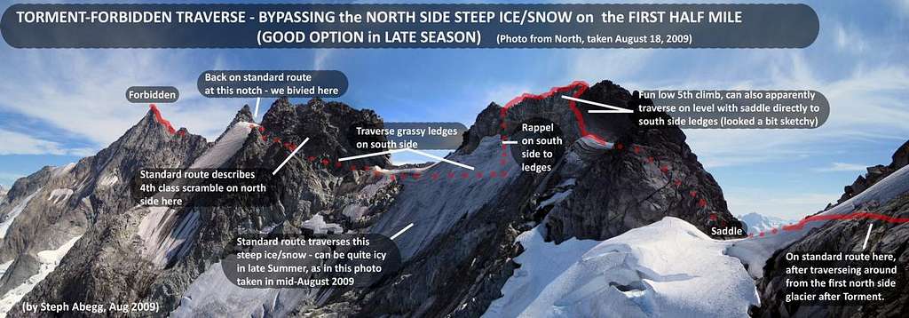 Bypassing the steep ice on Torment-Forbidden Traverse
Standard Route
It is commonly accepted among the mountaineering community that the West Ridge is the standard route up the mountain. Technically there is a "easier" route but it is said to be sketchier and less people actually do it. And besides, this is route is a classic!
The trip starts out as a road walk towards Boston Basin. The road eventually turns into a trail which by hiking standards is steep, but is normal for climbers. On the way up there are two small creeks and a minor scramble spot in the trail. As you hike through the woods you get a few teaser views of Johannesburg, Hidden Lake Peaks, and of the Cascade Valley. As you get close to Boston Basin you break out of the trees and finally get your first glimpse of Forbidden Peak.
 Hidden Lake Peaks Hidden Lake Peaks |
 Cascade Valley Cascade Valley |
 Steep Section of the Trail Steep Section of the Trail |
 Johannesburg View Johannesburg View |
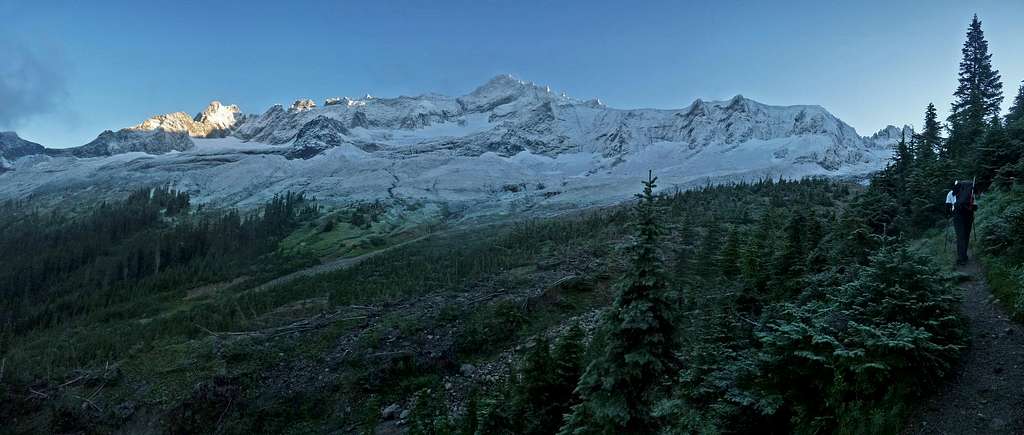 Torment and Forbidden Peak on the way up to Boston Basin
Once your in Boston Basin the trail continues although is a little spotty in a few places. The trail curves northwest towards the rib of Forbidden. Once your in the upper part of Boston Basin the trail fades away after passing "Forbidden Camp". From here head towards the waterfall slabs. Technically one can climb through them at the right spots, but I suggest heading all the way to the far left side avoiding slick slabby terrain. Once your on the slabs head lightly right for a short distance and aim for the glacier.
 Approaching Forbidden Approaching Forbidden |
 Boston and Sahale Reflection Boston and Sahale Reflection |
 Marmots in Boston Basin Marmots in Boston Basin |
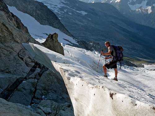
 Hiking up the Slabs Hiking up the Slabs |
 Route Diagram of the Gullies
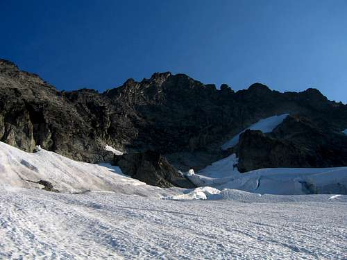
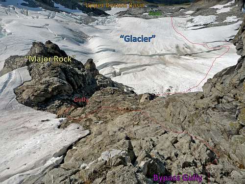
Once you arrive onto the glacier, head northeast aiming for the left side of the major rock at the end of the glacier. You might have to zig zag a moat or two, but the navigation on the glacier is very straight forward. Near the top of the glacier traverse right toward the "major rock" (the one right below the bypass gullies). Getting off the glacier might be interesting. Carefully scramble your way down into the rock gully.
 Approaching the Exit Approaching the Exit |
 Trappers Mountain to the SE Trappers Mountain to the SE |
 Glacier "Crevasses" (Moats) Glacier "Crevasses" (Moats) |
 Bottom of the Gully Bottom of the Gully |
 In the center of this Photograph is the "Major Rock"
 Overhanging Moat Exit... Don't worry, it's not that bad
Once your in the rock gully, head to the top of it going slightly right. During late summer you may wish to ditch your snow gear here. From here you'll see a gully on your left, this is the main bypass gully. It starts out as a scramble but gets a little trickier as you go up. After about 100 feet you arrive at the first rappel anchor which is where the fun begins. Get your harness, pro, and rope out and begin the first pitch.
 Bypass Gully Diagram looking Down
First Pitch: The gully itself is mostly scrambling but has a few moves involved. It's easy enough to "safely" simul climb but certainly exposed enough to make one want to stay roped through out the gully. The rock is mostly solid until you get to the top. Once you reach the top of the first pitch unrope and scramble up to the bottom of the West Ridge. Careful not to knock down rocks on the scramble section.
Gear Used for First Pitch: 2 slings, 2 quick draws, number 1 cam, number 2 cam, .3 cam, .4 cam, and 2 nut cams.
 The Main Gully The Main Gully |
 Climbing in the Gully Climbing in the Gully |
 Climbing the upper Gully Climbing the upper Gully |
 Exiting the Gully Exiting the Gully |
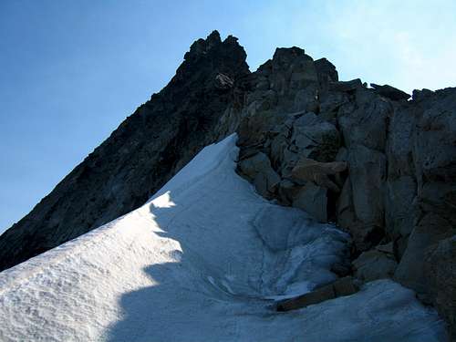 Beginning of the West Ridge
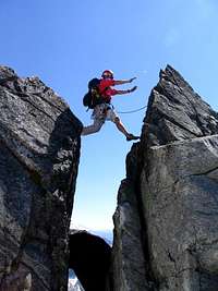
Second Pitch: This section of the climb requires a "air jump" across a rock gap. Don't worry, it's not that bad. If anything it's fun and neat to look at. Stay on the crest of the west ridge. If in doubt, go left onto the northern face. Most of the climbing on this pitch should not go beyond class 4.
 Climbing the Second Pitch
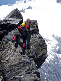
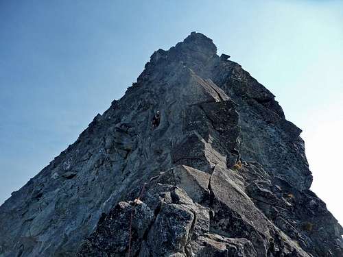
After the second pitch it's hard to define exactly what pitch your on because of the belay options. In general the route does no more than 4 full pitches (from bottom to top). Eventually you arrive at the crux tower, go left to avoid ending up on the West Ridge Direct.
 The Crux Tower
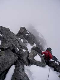
Soon after you arrive to the false summit. Carefully down climb it and head up to the real summit (losing about 10 feet of elevation). You've reached the land of Forbidden Places. Congrats. Just make sure you get out of the realms of the Forbidden castle before the night falls.
Red Tape
Wilderness Permits are required. They are also VERY hard to get on a summer weekend - Boston Basin is some kinda officially designated Alpine-meadow sensitive area or something. it is amazingly beautiful. My advice: Get your permit Thursday night or Friday morning at the Ranger Station in Marblemount. Afterhours, you can self-issue and on Thursday nights, the limited sites are never full (so far). Boston Basin is "Crosscountry I Zone" and maximum of 6 parties at any given time. I have met Rangers every time i've been in the area (3 years running) and they are always nice and always ask for your permits!
Lots of hikers drag up there to look around and it's also the starting point for climbing Sahale Peak by Quien Sabe Glacier, Mt Buckner's North Face, etc.. Wilderness permits are free and the trailheads are (barely) in the N Cascade National Park so you DO REQUIRE a Northwest Forest Pass permit ($5/day or $30 annual).
Despite what it says on the NPS website (below) do not be confused: you do need to go to Marblemount Ranger Station for permits into Boston Basin, they cannot be issued from Methow or anywhere else.
North Cascades NPS Fees and Permits
After you become confused you can call the WIlderness Information Center at (360) 873-4500 x39 (May - October).
There are no seasonal closures, just a severely limited user number. Brown bears have been seen at both the low and high basin camps so stow your food appropriately. There's a nice 3 meter boulder problem just "east" of the porta-pot at the main upper camp 6050ft - make it interesting by taking your food bags up there clenched between your teeth with your headlamp in the dark...
Ther are lots or marmots and some pikas around as well and a tremendous amount of huckleberries in the Fall. There's lots of granite, running water, and flora so stay on trails!
When To Climb
Hmmm.... when to climb. Well, I've tried June (too much snow on the rock), I've tried late September (big blizzard the night we camped out put too much new snow on the rock), so I must agree with the guides and go for 2 thumbs up on mid-JULY to late AUGUST!
Warmer years subtract a few weeks off the front, etc. etc. etc.
ONE big note: access to the West and North Ridges can change significantly when out of season. Lately, with the global weather patterns like El Nino etc. the West Ridge couloir has been melting out completely by August. This means that 700ft of generally decent 45 degree snow becomes 700ft of nasty-loose-falling-ever-so-lightly-on-your-partner's-head ROCK. This makes for an extra Alpine Grade on that route. If heading over to the North Ridge by Sharkfin col, which i have yet to do, i have talked with some guys who like to minimize the length of rotten gully leading up to the col (which is 5.5+) by taking it pretty early. Note that the West Ridge was first climbed in APRIL 1940 (unsuccessfully) and then JUNE by L. Anderson with some punk kids named Fred and Helmy Beckey. So if snow en route on rock doesn't bother you, the West Ridge (straight-forward ridge climb with one crux 5.4-5.6) early is good. The East Ridge Direct early may be a LOT more difficult (ridge with multiple gendarmes/by-passes 5.4-5.6 and vertical 5.8 crux well into the climb) when there's snow on it compared to the West so maybe that should be done "later".
Camping
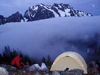
camping
Camping is in "designated Wilderness sites". There's a map of them available at the Wilderness Center in Marblemount. High camps are at 6350-6600 ft around an old moraine while the Lower Camps are at 5600-5800 or so. The high camps are best for the Forbidden Peak climbs and bivy sites up on the lower spur to the East Ridge adjacent to the glacier are also possible. There's no camping on exposed, fresh earth or flora / tundra... camp on bare rock/snow or in the designated spots!
No fees to camp. No fees to climb. Only a fee to park at the trailhead.
Mountain Conditions
When the weather is good one can safely climb this mountain — but when weather turns bad this mountain lives up to it's name! So be smart, check the conditions, watch for changing weather, and know when to turn around.
To see up coming weather conditions check in with the Noaa Forecast.
November through April be sure to check in with the Northwest Avalanche Center. Most folks wouldn't even try this peak at that time of year, but there are some hard core climbers out there. Conditions are less than forgiving during the winter months on this peak.
For road Conditions check in with National Park Service Website and scroll to where it says "Cascade River Road".
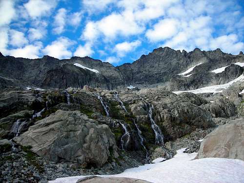 Forbidden with Fluffy Clouds and Waterfalls
Topographic Maps
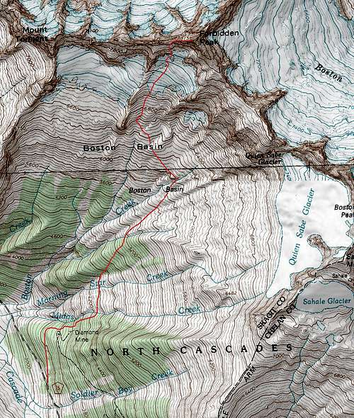 Forbidden Peak Topographic Map