
|
|
Mountain/Rock |
|---|---|
|
|
37.33900°N / 118.655°W |
|
|
13652 ft / 4161 m |
|
|
Overview
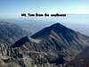
Mt. Tom is the immense, good-looking peak just west-northwest of Bishop. It is situated right on the eastern edge of the Sierra crest, allowing for a very large vertical relief. The Owens Valley, at the base of Mt. Tom, is a little over 4,000 feet, and the summit of Mt. Tom is nearly 14,000, for almost 10,000 feet of relief. Most routes allow some elevation gain before arrival at the trailhead/departure point. None of the recognized routes are technically difficult, most are class 2-3, but they are all strenuous and long. The views from the summit are memorable, and you are unlikely to see many tourists along the way. This peak does not get very many ascents, the summit register is sparsely signed.
This is one the few Sierra peaks that Norman Clyde is not credited with making the first ascent.
 |
 |
 |
 |
 |
Getting There
Mt. Tom is about 10 miles outside Bishop, California, and you should consult the individual route descriptions to decide how to access the peak. For the east to north side routes, access is via Pine Creek Road, a clearly marked turnoff from Highway 395 North. For the south side routes, leave Bishop on Highway 168 headed west. In about seven and one-half miles, you will see the Buttermilk Road on your right. Follow this road, which leads past the famous Buttermilk Boulders, until you reach a fork at 1.7 miles. Take the right fork, continue until mile 6.2, and again take the right fork. In a mile or so, you will find a nice shaded parking area, and the Horton Lakes Trailhead is another one-third mile or so. There are many side roads, if in doubt follow the most heavily traffic'd direction.
 |
 |
Red Tape
There are no permits required, and the Horton Lakes Trail is non-quota.
When To Climb
The mountain may be climbed in any month of the year. There are many good ski descents to be had, Elderberry Canyon being the most well-known. This is a fine, steep, spring skiing bonus.
 |
 |
 |
 |
Camping
Camping is available at the Horton Creek Campground and, as of May 23 2005, there is a fee of $5 per night with a maximum stay of 28 days in a calendar year. Prior to that date, the camping was free. There is no potable water at this campground. The campground is generally open from April 20 to November 1. Click here for additional info on the Horton Creek Campground. Primitive camping is also allowed at the trailheads listed above.
Mountain Conditions
webcam!
If you need more, you might try the Inyo National Forest facility in Bishop at 873 N. Main St., Bishop, CA 93514 (760) 873-2400. Or contact them here.
A little bit of history...
Mt. Tom was named after Thomas Clark, who claims to have been guided to the top by Indians, for the first known ascent of the peak, in the 1860s.
From Place Names of the Sierra Nevada, by Peter Browning
Elderberry Canyon began to be noticed when Stanley Lambert discovered tungsten deposits near the head of the canyon in 1940. In 1941, Lambert leased the property to Kenneth Irons, who hired a crew and built the 6-mile long trail up Elderberry Canyon. The trail switchbacked steeply up the canyon for a 4,600' gain. The trail was used to pack in the mining paraphenalia, and to remove (by mule) a few hundred tons of high grade ore in 1942 and 1943. By then, most of the ore body was mined out. In the early 1950s an attempt was made to build a road all the way up to the mine, and reached nearly 8,000' before the developers gave up. This road is still recognizable from the Owens Valley, it switchbacks up the next gully to the east of Elderberry Canyon.
From Mine in the Sky, by Joseph M. Kurtak
fogey - May 30, 2013 10:47 pm - Hasn't voted
Tungstar Mine historyWith time on my hands in the passenger seat heading home on 395 after climbing Tom, I learned from an old USGS report found online: The ore mined at Tungstar was discovered in 1937. Production started in November 1939, using a 2.6 mile tram to a mill near the junction of Pine and Gable creeks at about 7400 feet. Production ended in October 1946, when the mine installations and upper tram terminal burned; the mill and office buildings were destroyed by a 1951 snow slide. The quality of the ore deteriorated from about 2.7% tungsten trioxide early on to less than 1% toward the end. (Searching "Tungstar Mine usgs" should turn up a link to the report, which has many obscure details--ever wonder what a glory hole is?) As of 1948 (judging by the date on one of the report's drawings): "The best means of access to both mines is by Jeep, driving up the Hanging Vallay mine road. This road follows Horton Creek, on the south side of Mt. Tom, to Horton Lake then switches spectacularly up a steep 2,000-foot high escarpment north of the lake."