
-
 433881 Hits
-
 99.85% Score
-
 151 Votes
|
|
Mountain/Rock |
|---|---|
|
|
40.25470°N / 105.6153°W |
|
|
14259 ft / 4346 m |
|
|
Overview
Long's Peak stands proudly as Colorado's northernmost fourteener. It is unquestionably the monarch of the Front Range and northern Colorado. It is not only the highest peak in Rocky Mountain National Park and Boulder County, but it is also the 15th highest peak in Colorado. It's close proximity to Denver and its pure majesty make it the most popular climbing mountain in the state. The Keyhole Route described below is the most climbed route of any fourteener route in the state and is a true classic climb. It is not uncommon to have over 100 people on the summit at a time on a busy summer weekend, and long lines of people following each other up and down the mountain, often too close for comfort. The Keyhole route will attract several thousand climbers every summer. Routes up the mountain range from the Class 3 Keyhole to the Hornsby's Direct Route rated at 5.8. There are several trailheads, but most routes and variations start from the Long's Peak Trailhead.
 |
 |
 |
 |
 |
Getting There
The Long's Peak Trailhead is at 9400 feet and provides access to the East Long's Peak Trail. The trailhead is west of Colorado 7 and can be reached from the north or the south. For the northern approach, drive 9.2 miles south from the intersection of US 36 and CO 7 to the turnoff for the Ranger Station. For the southern approach drive north 10.5 miles from the junction of CO 7 and CO 72 on the Peak to Peak Highway to the Ranger Station turnoff. From the turnoff drive west 1 mile to the trailhead. The trailhead is accessible in winter.
 |
 |
 |
 |
 |
The Main Routes
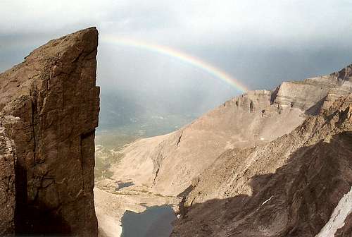 Longs Peak Rainbow from Chasm Overlook above Boulderfield Camp
The Keyhole Route is by far the most popular route on the mountain. From the Long's Peak Trailhead the route is a classic class 3 climb and measures 15 miles round trip with 5000' elevation gain.This is a long, arduous ascent normally that gets quite difficult and even dangerous when conditions are bad. Many people have died on this route. Summer storms can makes the Homestretch quite slippery, and the Trough will normally require an ice ax through mid July. The route spirals almost completely around the mountain and bailout descents will likely take you down Wild Basin or Glacier Gorge and make return to the trailhead a difficult proposition. Even when conditions are good the crowds make falling rocks a very real threat.
From the Trailhead follow the well marked trail 5.9 miles to the Boulder Field at 12,750'. Continue southwest to the Keyhole at 13,150'. Be sure to follow the painted bull's-eyes marking from here. Scramble on another .3 mile to the large couloir called the Trough. Climb the Trough to the Long's west ridge. Save your strength for the last 1,000 feet, you will need it. Just before reaching the ridge you must pass a chockstone, probably the most difficut move on the climb. At the top of the Trough cross to Long's south side and travese across the south face along the exposed Narrows ledge. Continue about 250 yards past the Narrows to the base of Homestretch. Cross the slabs carefully, especially if they are wet. Past the Homestretch its a 100 foot walk up to the summit. Whew!
For a variation the climb up the Trough from the Glacier Gorge trailhead offers one of the longest snow climbs in Colorado. Be careful of falling rocks on this route from other climbers.
Technical routes include the Keyhole Ridge route (5.5) Kieners (5.3-5.4) Alexander's Chimney (5.5) Stettners Ledge (5.7+) and Hornsbys Direct (5.8). All start from the Long's Peak Trailhead. For more details see the "Route Section" of this page for information on Kieners.
Lavaca also adds this information: Though the Keyhole and Kiener's route are by far the most popular, there are many popular purely technical routes on the 900 foot north-east granite face, known as the Diamond. The routes here range from 5.10a (the Casual Route) to The Honey Moon Is over, which is around 5.13. All of these routes are at least 9 pitches or so starting from the huge ledge that runs across the face around 13,100'. Guidebooks that cover these routes are easy to find.
 |
 |
 |
 |
 |
Mountain Conditions
For latest information call Rocky Mountain National Park at 970-586-1206 or you can go to RMNP weather page for up to date weather forecasts. Mountain Conditions. You can also see the current conditions at Long's Peak Webcam.
Conditions on this mountain, like all Colorado 14ers, are subject to change rapidly- especially during the prime climbing summer season. The mountains are their own weather system, and weather forecasts from nearby towns often have little to do with actual mountain conditions. You can generally count on clear to partly cloudy in the morning, and heavy clouds and thunderstorms in the afternoon during the summer.
There is no substitute for getting an early start, and getting as much of the mountain "behind you" as early in the day as possible. Keep a good eye on the sky as weather conditions can deteriorate rapidly. The greatest weather danger is from lightning strikes, and climbers are killed almost every summer in Colorado by lightning strikes. July seems to be the most deadly month for lightning.
Two climbers were killed by lightning in Colorado within a couple days of each other in the summer of 2003. I think the following important information from Gerry Roach's book "Colorado's Fourteeners From Hikes to Climbs" bears repeating. Added here with permission from Gerry Roach:
Colorado is famous for apocalyptic lightning storms that threaten not just your life, but your soul as well. This section will have special meaning if you have ever been trapped by a storm that endures for more than an hour and leaves no gap between one peal of thunder and the next. The term simultaneous flash-boom has a very personal meaning for many Colorado Climbers.
Dangers
1. Lightning is dangerous!
2. Lightning is the greatest external hazard to summer mountaineering in Colorado.
3. Lightning kills people every year in Colorado's mountains.
4. Direct hits are usually fatal.
Precautions
1. Start early! Be off summits by noon and back in the valley by early afternoon.
2. Observe thunderhead buildup carefully, noting speed and direction; towering thunderheads with black bottoms are bad.
3. When lightning begins nearby, count the seconds between flash and thunder, then divide by 5 to calculate the distance to the flash in miles. Repeat to determine if lightning is approaching.
4. Try to determine if the lightning activity is cloud-to-cloud or ground strikes.
5. Get off summits and ridges.
Protection
1. You cannot outrun a storm; physics wins.
2. When caught, seek a safe zone in the 45-degree cone around an object 5 to 10 times your height.
3. Be aware of ground currents; the current from a ground strike disperses along the ground or cliff, especially in wet cracks.
4. Wet ropes are good conductors.
5. Snow is not a good conductor.
6. Separate yourself from metal objects.
7. Avoid sheltering in spark gaps under boulders and trees.
8. Disperse the group. Survivors can revive one who is hit.
9. Crouch on boot soles, ideally on dry, insulating material such as moss or grass. Dirt is better than rock. Avoid water.
The following link is also helpful: Lightning Safety and Crouch
Also see this report by nchenkin It will make you really think about lightning safety: Struck By Lightning!
 |
 |
 |
 |
 |
Camping
There are 26 camping pads at the trailhead- right next to the ranger station. They are available first come first serve - no reservations are accepted. It is tent camping only, with toilet facilities, benches, and fire pits. As of 2009, camping at Longs Peak CG is $20 per night when the water is turned on (~Late May through ~mid-September) and $14 per night otherwise (i.e. when water is turned off.) From this site to the boulderfield campsite is about a 3 hour hike.
The choice is this: If you want to make a longer day and camp at the trailhead site, you will get to the boulderfield about sunrise- about the same time as those that camped there are about to leave. I would say if you dont mind 3 hours longer hike - hike from the lower site and save having to lug tents and stuff to boulderfield campsite.
But if you want an easier summit day, camp at boulderfield. Camping is allowed at the Boulder Field but you must check in with the Ranger Station first. It is first come first serve so get a hold of the Park Service well in advance of your visit to avoid any undesirable encounters with the Park Service.
Lavaca adds: Though the Boulder field is the only place to set up tents on the mountain (and I think the spots get taken months in advance), you can bivouac at certain areas. Chasm View and Mills Glacier are the only two places I know of, but there are likely more. These sites have some flat areas under boulders if you look hard. Again, you need permits to sleep here. Chasm View is around 13,500' and the Boulder Field is around 13,000', so be ready for high-altitude camping
 |
 |
 |
 |
 |
When To Climb
Summer is easiest and most popular. July and August tend to be peak season. Try to climb during the week if possible to avoid the crowds- this is a VERY popular mountain. Colorado mountains are famous for afternoon storms. Try to climb early and as a rule of thumb be off the summit by noon. If you are going to do this mountain in one day you will need to start well before sunrise to be off the mountain before the afternoon storms come in. Also, due to the crowds on this mountain it is best to climb and attempt summit on a weekday if possible. You should also leave the trailhead as early as possible. Starting out at 1:00 AM could take11 hours roundtrip and just miss the afternoon thunder boomers.
If you are an experienced and well prepared winter mountaineer, than this can be one of the most peaceful and beautiful winter climbs in the Front Range. If you plan on climbing this mountain in the winter add 2-4 hours to your journey and be prepared to set up a winter camp. Expect arctic conditions in the winter. The wind can be relentless and demoralizing. While snow depth is usually not a problem, snowshoes are recommended for spots once you leave the trees but before the Boulder Field. Expect dangerous exposure combined with mixed climbing on the Keyhole in the winter. This route is usually avoided when it's icy, wet, or windy. Stick with the NE face, which is windswept and a better line in the winter (crampons still required).
 |
 |
 |
 |
 |
People Pics
Add your People Pics here.
 |
 |
 |
 |
 |
No Dogs Allowed
pjenson5 reports:
You are not allowed to bring animals (i.e. Dogs) on Longs Peak. They say that they urinate everywhere and scare away the natural wildlife.
 |
 |
 |
 |
 |
External Links
COLORADO 14ERS INITIATIVE LEARN MORE ABOUT COLORADO 14ERS AND VOLUNTEER OPPORTUNITIES
Leave No Trace
Check out the web site of LNT and learn some important minimum impact hiking tips.
Colorado Mountain Club
CMC’s web site will tell you all you need to know about Colorado’s largest and oldest hiking club.
- A personal site with pictures, video and stories about climbing big mountains around the world.
Mountains include Cho Oyu, Ama Dablam, Denali, Grand Teton, Longs and more. - Longs Peak Keiners Route
- Longs Peak, North Face a.k.a. Cable Route, Winter
- Longs Peak, the Keyhole route
- Long Peak 2001
- 14ers.com - The Home of Colorado's Highest Peaks
Fourteener Photos, Route Descriptions, Forum, and more...
Parting Shot- May All Your Days be Filled with Rainbows
Longs Peak Rainbow from Chasm Overlook above Boulderfield Camp
395guy - Jun 9, 2003 3:28 pm - Hasn't voted
Untitled CommentAs I was searching for info on Long's Peak on the web, I came across the odd fact that the ashes of Doak Walker were scattered on Long's Peak. Walker died on September 28, 1998 from complications from a skiing accident. He was famous for winning the Heisman trophy at SMU in 1948 and being exemplary in his academics and citizenship. He was a 4-time All-Pro with the Detroit Lions and led them to NFL championships in 1952 & 1953. He's the namesake for the Doak Walker Award (see www.doakwalkeraward.com) for college football's best running back.
You can read about the ashes on Long's Peak at:
http://www.findagrave.com/cgi-bin/fg.cgi?page=gr&GRid=3750
brutus of wyde - May 5, 2009 8:08 pm - Hasn't voted
Camping fees at Longs Peak CGAs of 2009, camping at Longs Peak CG is $20 per night when the water is turned on (~Late May through ~mid-September) and $14 per night otherwise (i.e. when water is turned off.)
gadams01 - May 23, 2016 6:56 pm - Hasn't voted
weather around Juneme and some buddies are heading up there to climb longs around June 19 and i was wondering what the weather and how much snowfall is usually there to see if we will need crampons? Any feedback will be very helpful.