
-
 18748 Hits
-
 85.87% Score
-
 21 Votes
|
|
Mountain/Rock |
|---|---|
|
|
46.94264°N / 12.69823°E |
|
|
Mountaineering, Ice Climbing, Scrambling, Skiing |
|
|
Spring, Summer, Fall |
|
|
10629 ft / 3240 m |
|
|
Overview
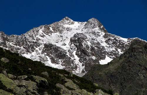 DomiterLori - Hochschober from the SE
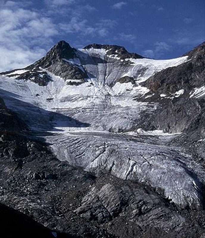
What's New On This Page?
> May 29th, 2013: SP V3 design updated.
> Jun 14th, 2005: Peter Cornelius Spaeth's north face remark inserted.
> Jul 25th, 2004: Link to the Schober GROUP inserted.
Hochschober Gets Presented
Hochschober is the most beautiful mountain of Schober Group, although it is not the highest one. This group stands south of Grossglockner Group. Its peaks are rocky and steep, but although many of them reach altitudes above 3000 meters, glaciers are rare.
Hochschober is a pleasant exception. Its 500 meters high north slope is covered by a glacier, up to 45 degrees steep. The most beautiful view on it is from the north, from Lesachtal. Today, probably the majority of mountaineers ascend Hochschober from the south, from Hochschober Huette (2322 m). The other possibility (with the previous one ideal for crossing) is by the southeastern slope and on the upper part SE ridge. Both these are in high summer covered by some snow only on the upper part, so the ascent is only a moderately difficult one. The third possibility for ascent is from Lesachtal, from where you reach Schobertoerl and then by a beautiful crossing of Kleinschober (3125 m) reach the main summit by its NE ridge. It is of course possible also to climb the summit directly over the north slope.
The difficulty of this tour depends on snow conditions. In good conditions this is also a tour for good mountain skiers. The mountain stands in the western part of mountain group, in a strong crest, running towards the north-east. Besides its 500 meters high northern slope nice is also the summit ridge, runnig on the neighbouring Kleinschober, 3125 m. The crossing of both summits some time runs on a quite high altitude.
The first ascent of Hochschober is attributed to Franz Keil (an artist, well-known in his time for constructing reliefs of mountans!) and his friends, who ascended the mountain on August 18th, 1855, directly from the SW. It is possible that the mountain had been climbed earlier by military mapmakers! First ascent by today normal route by the W-ridge was done by Ludwig Purtscheller on July 24th, 1890. First ascent of northern flank was done by L. Bergmann and friends on July 25th, 1928.
Getting There
|
Routes Overview
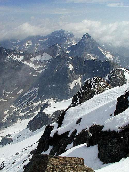 Summit view
 On the west ridge
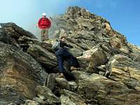 DomiterLori - On the SE ridge
Summer Routes
1. West Ridge - Over Staniska Scharte. The marked route ascends from Hochschober Huette to Staniska-Scharte (2990 m) and then by the western ridge to the top. It avoids any glacier sections, but also in summer you need to have ice pick and crampons. This is the normal ascent, medium hard hike up.
2. From Staniskatal. Staniska-Scharte can also be reached from the west through Staniskatal - 1900 m of altitude difference!
3. Southeastern slope and on the upper part SE ridge. Either from Hochschober Huette or Lienzer Huette to Gartl and then over the SE slope to the top. Marked, difficulty equal to #1.
4. From Schobertoerl over Kleinschober and the E ridge. Schobertoerl, 2905 m, can be reached either from Lesachtal, from Debanttal (Lienzer Huette) or from Leibnitztal (Hochschober Huette). The part to Kleinschober is an easy rock climb (UIAA II), often icy, because of the N slope. From Kleinschober to the main summit easy snow ridge.
5. North face. Easy glacier tour, up to 45 degrees steep. The glacier is retreating in the last years, so come early in summer.
Ski Tour
1. North face. See Herbert's excellent route description!
Books & Maps
See also:
- Peter Freiberger: Berge Tirols. Bruckmann, 2000.
- Sepp Schnuerer: Hohe Tauern. BLV Verlagsgesellschaft. Muenchen, 1990.
Maps:
- Kompass Wanderkarte, 1:50000.
- You can see a detailed map (1:50000) on-line on: http://www.austrianmap.at/.
- The best map is Alpenvereinskarte (map of the german alpine club) Nr. 41 Schobergruppe 1:25.000, can be ordered at DAV Life Alpin (online shop) - click here.
Red Tape
No limitations. The upper parts of mountain roads are closed for public traffic.
When To Climb
The best time for the southern and eastern ascents is summer and autumn, July - October. For the northern slope glacier ascent come early in summer, or even late in spring. For good skiers the northern slope can be also done with skis. It is steep, take also care of avalanche danger! PeterCorneliusSpaeth: Once the north face was a nice little ice climb. As of now (post 2003) it is no more worth visiting. Lots of stones melting through and the ice is rapidly retreating.
Camping
 Hochschober Huette and the summit behind
> Hochschober Huette, 2322 m, tel.: 0043 / (0)663 / 57722. Peter Cornelius Spaeth Says: "Hochschober hut is a very recommandable, friendly place to stay. E.g. once I arrived near 10 pm, they still cooked something for me."
> Lienzer Huette, 1977 m.
> Lesachalmhuette, 1828 m. You can get toourist information in: Tourismusverband Iseltal, 9900 Oberlienz. Tel.: 0043 / (0)4852 / 64759.
External Links
- Hochschober normal route professional done trip report with pictures on the website of the Bergrettung Lienz (mountain rescue team from the town Lienz)
- Picture of a ski tour route:
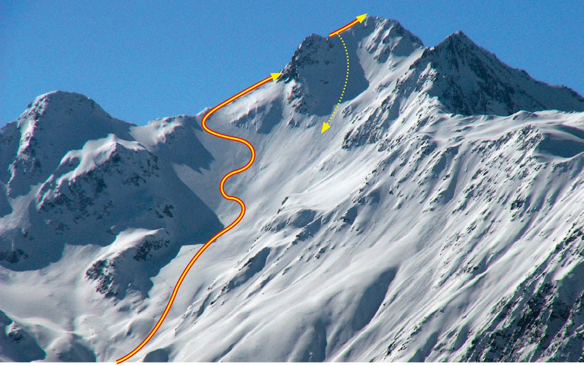 Mariacher: Hochschober ski tour route
PeterCorneliusSpaeth - Jun 14, 2005 8:10 am - Hasn't voted
Untitled CommentOnce the north face was a nice little ice climb. As of now (post 2003) it is no more worth visiting. Lots of stones melting through and the ice is rapidly retreating.