
-
 17293 Hits
-
 85.87% Score
-
 21 Votes
|
|
Mountain/Rock |
|---|---|
|
|
46.44930°N / 14.68606°E |
|
|
Hiking, Mountaineering, Scrambling, Skiing |
|
|
Spring, Summer, Fall |
|
|
6328 ft / 1929 m |
|
|
In Slovenian language č, š and ž are pronounced like ch, sh, and zh. Our mountain is written Olševa and pronounced like "Ousheva".
Overview
 flow - On the ridge of Olševa
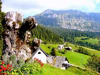 hunkan - South face and foothills
 flow - The summit ridge with Obel kamen in the middle
What's New On This Page?
> Jan 22nd, 2019: Design corrections.
> Jun 29th, 2017. Geological outline added.
> Oct 20th, 2013. A major update - pictures, routes, links.
Topographic Names
The now prevailing Slovenian name is Olševa. Austrian people use a direct transcription into German and write the mountain as Uschowa. The highest point of the ridge bears the name Govca, also Govešča (on the southern side also Govejšca).
Olseva Gets Presented
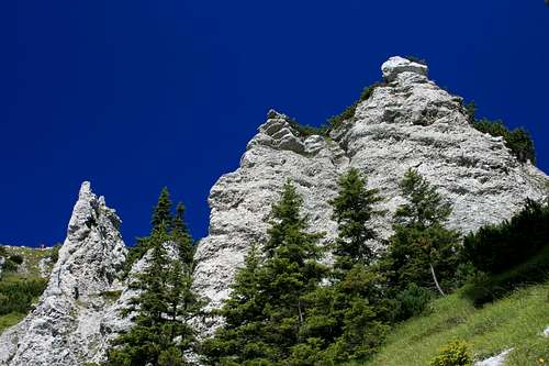
Olševa/Uschowa is a special mountain. Not because of it's height or big walls, but because of a few special treasures it hides. The mountain has a shape of a 5 km long ridge, with the following summits (from the W to the E): Obel kamen, 1911 m, Govca, 1929 m, Gladki vrh, 1850 m.
Obel kamen is quite a rocky summit, Govca is already grassy, but still surrounded by rock towers and walls, but towards the east the ridge gets mostly grassy. It's a very beautiful ridge - on the upper forrest border you will find nice larches, and soft, dense grass, through which the path goes by the top of the ridge.
Olševa rises north of the upper part of Savinjska dolina (valley), above Solčava, 659 m. From there it is seen as a broad, mostly grassy mountain which slopes are however on many places intermitted by limestone rock cliffs and towers. On the altitude of 1050 m to 1250 m along the southern side of the mountain a nice sunny terrace stretches. There are scattered many beautiful farms of Podolševa. From this terrace down to Savinjska dolina some crags are falling. The most known is Strelčeva peč, 1336 m. In it there are a few harder climbing routes of difficulties up to UIAA degree V.

The view from the west on Olševa is much different. From Remschenig / Remšenik valley it is seen as a sharp rocky cone, rising from the woods. From the northern and eastern side the views on Olševa are less spectacular.
Olševa is primarilly a goal of hikers who are coming on top from all sides. The most popular ascents are from the south, but also the one from Austrian side is very nice and used. In winter the area is quite remote. Even if Olševa offers also options for tour skiing, the ravines in its northern side are in winter rarely visited. The sunny terrace of mountain's southern side is very popular for mountain biking. The panoramic road offers some very nice variants of round bike tours. From the summit of Olševa views are very nice, especially towards Kamnik & Savinja Alps.


Potocka zijalka
First of the 'hidden pearls of Olševa' is a cave on the altitude of around 1700 m, named Potočka zijalka (115 m long, 20-40 m wide). It wouldn't be so special, because in limestone caves are frequent, if there in the past so many relics of old stone age men weren't found. If you are watching from the cave entrance towards the warm south, enjoying broad panorama, you can easily imagine how thousands of years ago men gathered there around a camp fire, how they lived in the interior and how from that point they monitored a broad hunting teritory around. Besides men made tools (the oldest needle in the world) also some hundreds of cave bear skeletons were found there, indicating that Potočka zijalka was an important hunting point at the dawn of humankind in Europe. Today, the artefacts of Potočka zijalka are kept in the museums of Celje and Ljubljana.
 Felsentore/Vrata
Felsentore / Skalna Vrata
The second pearl are beautiful stone arcs (Skalna vrata, Felsentore). One of the side ridges on the northern side is all perforated. All right, this is not the Arches Park, but by all means it's worth visiting. That's perhaps why E. E. Huesler in his Bergwander Atlas Alpen chooses the tour through these limestone arcs as one of his favourites in the Karawanks mountain group. These two natural and archeological treasures plus a beautiful panorama from the top of Olševa are reasons why the peak is often ascended from the Slovenian and also from the Austrian side. See also the links chapter!
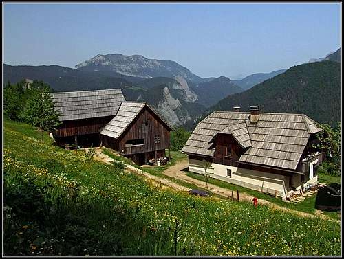
The Sunny Southern Terrace
Interesting is also the terrace, stretching south and southwest of the massif of Olševa. There are many old farms, connected by a very popular panoramic road. The views on the northern faces of Kamnik and Savinja Alps are exceptional.
The Crags above Savinja
From the terrace below Olševa a set of almost vertical, limestone crags are falling down to the upper Savinja valley. They are suitable also for harder climbing.
Geological Outline

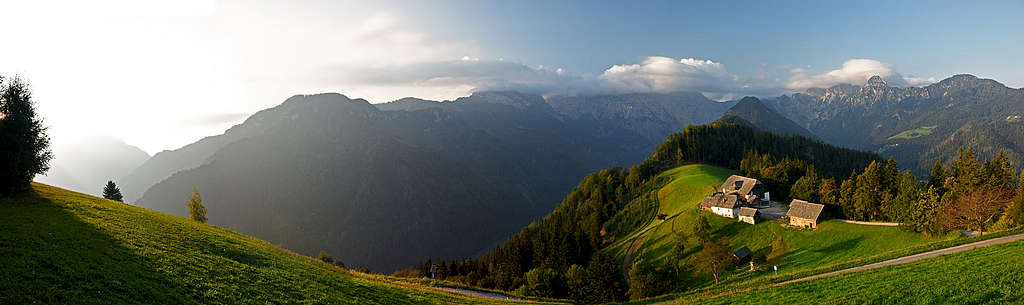
 From the southwest: Olševa, its southern terrace and the crags above Savinja river
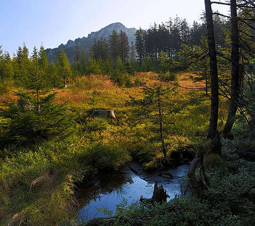
On the map above we see a part of the Karawanks range around Olševa - but only in Slovenia. The rocks structure, seen on this map, continues also towards the NW, into Austria. We see that west of Olševa there is an area, where old paleozoic rocks are on the surface (grey). Mostly clay slate rocks are from Carboniferous and Permian period, but on Veliki vrh, 1617 m (far on the left) there are even Devonian reef limestones, the oldest rocks in Karawanks (more than 350 million years). See the above picture, showing high moor on the very ridge of Karawanks, formed due to bedrocks which hold water.
Going towards the east, suddenly out of the woods white/grey dachstein limestones start rising. The whole Olševa range is build of those Triassic rocks, forming picturesque crags, spires, caves and rock windows. More towards the east, in lower region Triassic dolomites start replacing limestones.
The Border between Karawanks group and Kamnik & Savinja group is south of Olševa geographically set on Savinja river. But not geologically. We see that below the limestone summit ridge of Olševa there is the terrace of older paleozoic rocks. But from that terrace down towards the river of Savinja some steep, almost vertical limesone crags are falling (Klemenškova peč, Strevčeva peč, Huda peč, ...). They are made of older Triassic limestones, rising out of even older Triassic marls and sandstones. These rocks are the same as the rocks on the other side of Savinja river (more southwards) and are 'responsible' for forming the nice Podolševa terrace.
Finally, there's a completely different rock structure north-east of Olševa. Along the valleys of Remschenig/Remšenik (in Austria) and Koprivna (in Slovenia) the important Periadriatic fault runs. From the town of Eisenkappel / Železna Kapla towards the east a narrow belt of intrusive (volcanic) and metamorphic rocks is accompanying the Periadric fault. There we can find tonalite, gneiss, further on also granite. These areas are not any more so interesting for us (valleys), but those rocks determine how the landscape NE of Olševa looks like.
360° summit panorama
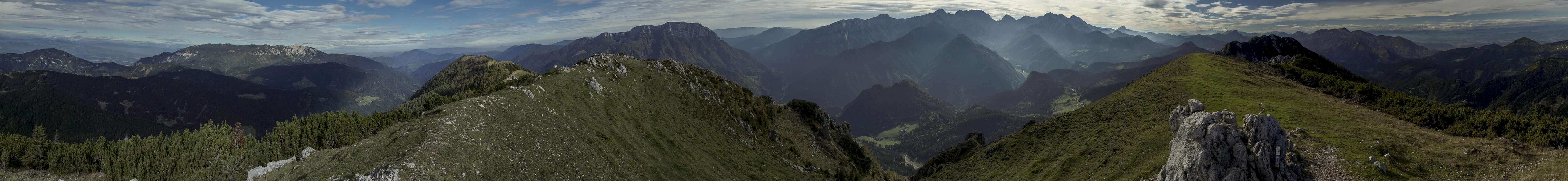
As Olševa rises in the very eastern end of Karavanke, the view from its summit towards the south, east and west flies far over the neighbouring hills. On the south west however, there are Kamnik & Savinja Alps which are high and wild. The view on those mountains is very nice, but often we are looking them towards the sun, so it is worth ascending Olševa early in the morning.
Getting There
Podolševa
The southern (Slovenian) approach is enabled by the panoramic road, going from Savinja valley (the town of Solčava) up on the terrace of Podolševa (Sub-Olševa), where several beautiful, separated farms lie. That beautiful patch of country is worth visiting itself. On the south oriented meadows there are many big picturesque farms, surrounded by nice trees and all of them enjoying great views on Kamnik & Savinja Alps. Many of those farms are offering local food and drinks, in some you can also sleep. The best time to visit Podolševa is autumn, also spring can be wonderful. Near the cute Sveti Duh (Holy Spirit) church there is the center where almost every visitor stops for a while to look around. You can park on the trailhead of any of marked paths, leading on top from the southern and eastern side.
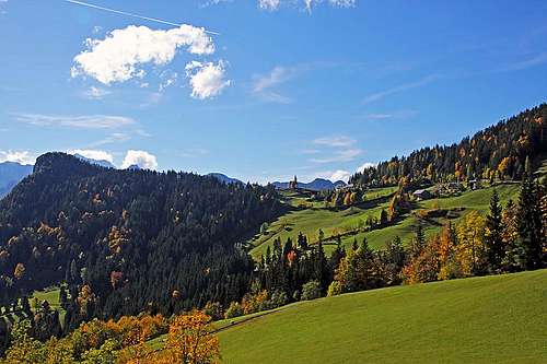 Podolševa landscape near Sv. Duh Podolševa landscape near Sv. Duh |
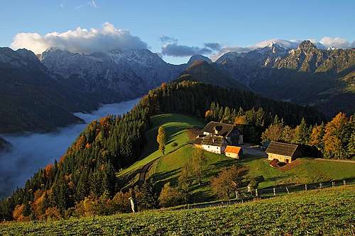 Klemenšek farm on Podolševa Klemenšek farm on Podolševa |
Remšenik
For the north-western approach, you take the road through the valley of Remšenik (Remschenig), which you enter near Eisenkappel / Železna Kapla, on the Austrian side. The first suitable trailhead is at the Kupitz inn (Gasthof Kupitz), 652m, where the route by St. Leonhard church and Heiligengeist saddle starts. At the end of the valley, you can park near the church of Šmarjeta (St. Margaret), 925 m, where the tour to rock windows starts.
Koprivna
For the western approaches you must drive in the valley of Meža. The town of Črna can be reached from the north from mežica town or from the south-east from Šoštanj. The end part of Meža valley is called Koprivna. From the settlement with the same name you drive further westwards, up the valley to Kos farm and further on Zadnji travnik (Last meadow). There the northern ascents start. From Koprivna, you can also drive around Olševa. The road first ascends the saddle of Spodnje Sleme and then continues by the southern terrace of Podolševa. You can see detailed on-line maps on:
> Austrian map.
> Geopedija.
> A good classical Slovenian map is: Kamniške in Savinjske Alpe, 1:50.000, Planinska zveza Slovenije.
Hiking Routes Overview
 On the ridge between Obel kamen and Govca
 On the East Ridge
Marked Paths:
There are many routes on Olševa. They can be best combined into round tours. Some proposals are at the end of this chapter.
1. From Sv. Duh via Potočka Zijalka (2 h, 30 min). Easy, but steep on some places (T3). Only a short passage is secured by pegs. Above the cave, one marked variant deters also left up on the summit of Obel kamen, and from there continues by the main ridge on the highest point. Nice, panoramic, but one degree more difficult (T4).
2. From Podolševa. Where the road from Solčava arrives on the mountain terrace, a marked path climbs steep grassy slopes and reaches the main ridge east of the main peak. 2 h 15 min. Steep path (T3).
3. From Remšenik. From the end of the valley we first ascend to the side ridge, where we visit the three rock windows (Felsentore/Vrata). Then we continue to the main ridge where just below Potočka zijalka this route joins the one from Slovenian side. After viewing the cave, by one of the two variants on top. 4 h, a few secured and exposed passages (T3).
4. By the east ridge. This is also a nice, but longer ascent which misses however the two landmarks of Olševa. From Spodnje Sleme pass we go by a cart road and then a marked path on the east ridge and by it beautifully on top. 2 h 30 min. Easy walk up (T2).
5. From the north. From Zadnji travnik (meadow) you take a marked path towards the south. It brings you on the main ridge east of the main summit. 2 h. Easy walk up (T2). The second variant goes even more towards the west - through the ravine of Mrzli dol. This ravine reaches the main ridge west of the main summit, near the rocks of Visoka peč (between Obel kamen and Govca). Both north variants are used as ski tour itineraries.
6. From Kupitz Guesthouse. This is also the approach from Remschenigg / Remšenik valley, but you park already at Kupitz inn, 630 m. From there you enter southwards the side valley, which starts with a nice gorge (Kupitzklamm, tourist attraction). After some 20 minutes you are at its upper exit and you continue towards the SE, to Schelesnigsattel (saddle), 1142 m, further on to St. Leonhard church, 1334 m, and on Heiligengeist saddle, 1432 m, on the main ridge. Some 3 h 30 min till there. On this saddle you hit the #1 approach route, but you have still some 1 h 30 min to the top.
Round Tours Proposals
1. From St. Margarethen to the rock windows, then to the main ridge and to Potočka zijalka, then to Obel kamen summit and by the ridge on the main summit. Then we return towards the west to the notch below Visoka peč, descend by Mrzli dol ravine and below keep left (pathless terrain). When in the woods reaching the saddle, turn left and descend to the church. Altogether 7 hours for the round tour.
2. From Sv. Duh church to Potočka zijalka and via Obel kamen on top. Then descend by the east ridge to Gladki vrh, 1850 m, and then either directly to the south or by the whole east ridge to Spodnje Sleme. Long way back by the road from there! Some 7 hours for the round tour with E ridge included.
Climbing
The upper massif of Olševa is not the best suited for climbing, the crags are too short. But the crags above Savinja river, so below the sunny Olševa terrace are hosting some routes:
- Klemenča peč (below the Klemenšek farm): 17 routes of lengths from 80 m to 300 m and difficulties of UIAA IV-VIII, or French up to 6c.
- Strevčeva peč (near Sv. Duh church): 2 routes of lengths 200 m and 550 m and difficulties of UIAA V- and French 7a.
- Golarjeva peč (between Klemenča and Strevčeva peč). A few quite difficult routes.
- Huda peč allows some scrambles, among them also to the misterious Hribarska zijavka (cave).
Tour skiing
Over the northern slopes two nice ski tours go. The area is remote, so usually we start the tours at the Potočnik farm in Koprivna. From there we must first reach Zadnji travnik (Last meadow) north od Olševa. If you catch powder snow in the northern ravines then all your efforts are well paid.
- Eastern ravine, 950 m, 3 h 30 min, PD. From Zadnji travnik we follow the marked summer route, going past the hunters hut on the summit ridge and right on the highest point.
- Dolgi žleb (Long channel), 950 m, 3 h 30 min, PD. Reaching Zadnji travnik we continue a bit more to the W, until the distinct channel, going up to the very summit ridge goes. After exiting it, left to the nearby summit.
Red Tape
No limitations.
When To Climb

All dry times of season, the best time is spring and autumn (September, October). For ski tours the best conditions can be from February till start of May. Weather: see here.
Camping
Around Olševa there are only many tourist farms, where you can also get accomodation. On older maps you will see near Sv. Duh also "Koča pod Olševo" (mountain hut), but in the recent years it is closed.
External Links
A few panorama pictures Pick up the panorama and roll it with your mouse.