
|
|
Mountain/Rock |
|---|---|
|
|
33.90580°N / 109.5625°W |
|
|
11420 ft / 3481 m |
|
|
Overview
Mount Baldy is the 7th highest point in Arizona, and the highest mountain not in the vicinity of Humphreys Peak. It is part of the White Mountains in eastern Arizona, and its summit lies within the White Mountain Apache Indian Reservation. The surrounding Apache-Sitgreaves National Forests offer thousands of acres of ponderosa pine, many lakes, good fishing, and great weather. Many Phoenicians make the 3-hour trek to the White Mountains to escape the heat in the summer and to ski at Sunrise during the winter. The Mount Baldy Wilderness offers some of the best forests in the state, and the hike up Baldy gives you a good taste.
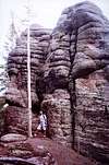
There are two established trails (West Baldy Trail #94 and East Baldy Trail #95) up Mount Baldy. Each is a moderate 7-mile (one way) hike and runs along a fork of the Little Colorado River through a lush meadow, enters deep pine forest, and climbs to a point near the summit of Baldy. The trails converge at a saddle around 11,200 feet elevation. The rest of the climb to the top of Mount Baldy is on the White Mountain Apache Indian Reservation and is closed to non-tribal members. The East Baldy Trail #95 offers some amazing rock formations and a view toward the southeast, while the West Baldy Trail #94 gives you a little more elevation gain (2,400 vs 2,100) and a view toward the north and west.
There's a 3.5-mile Crossover Trail #96 that connects the beginning of #95 with a point near the beginning of #94, so you can make a loop out of the hike. By my calculations, the loop is 18-19 miles long and makes a great day trip.
The Rodeo and Chedeski fire of 2002 and Wallow fire of 2011 destroyed hundreds of thousands of acres of forest land in the vicinity, but luckily Baldy was spared. There was no sign of the fire damage along the trails or within eye shot.
 |
 |
 |
 |
Getting There
From Show Low, drive south and east on AZ-260 for 40 minutes, past Hon Dah and McNary. Turn right on 273 as if you are going to the Sunrise Ski Resort. Drive on 273 for about 8 miles, past the entrance for Sunrise. The pavement soon ends and 273 turns into a well-maintained graded dirt road passable by most 2WD passenger cars.
West Baldy Trail #94 starts at Sheep Crossing Trailhead. The turn off is well-signed on 273. Another 4 miles down the road, you'll see the Phelps Cabin Trailhead, the beginning of the East Baldy Trail #95 and the Crossover Trail #96.
Red Tape
There are no fees for parking or use of the trail.
The only warning is that the summit of Mount Baldy is on the Apache Indian Reservation and is closed to all non-tribal members.
When To Climb
Baldy can be climbed any time of the year. It offers a cool hike in the woods during the summer and can be a great cross-country ski climb during the winter.
Camping
The closest developed campground is Winn Campground.
Open camping is allowed in the forest unless otherwise posted. Camping at the trailhead is not allowed.
Mountain Conditions
The Mount Baldy Wilderness is part of the Apache-Sitgreaves National Forests. Check with the forest ranger offices for latest conditions.
Andinistaloco - Oct 19, 2009 12:30 pm - Voted 10/10
Summit of Mt. BaldyHere's a word on the summit, since there seems to be a lot of confusion. Mt. Baldy has two summits - north and south. The north one is more the culmination of a high meadow on a ridge, whereas the south one is the more striking bald hump at the very end of the trail. Both of these summits (of course) look higher from the other one, and it's hard to say which might be higher. Herein lies the problem. According to older USGS maps, the reservation boundary line cuts between the two summits, which is why the southern one has technically been off limits to non-tribal members. Strangely enough, the newer USGS topo shows the boundary moved so that both summits are on the reservation... which means both may now be off limits. As far as elevation goes, the maps have the southern summit at 11403, whereas the northern one has no exact elevation... but the last contour line is at 11400, which would mean that summit could be anywhere from 11400 to 11439 feet. Though it doesn't necessary look as though it's higher, the map would suggest that it probably is.