

|
|
Mountain/Rock |
|---|---|
|
|
46.81630°N / 10.87000°E |
|
|
Hiking, Mountaineering |
|
|
Spring, Summer, Fall, Winter |
|
|
11342 ft / 3457 m |
|
|
Overview

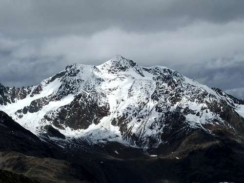
The Kreuzkamm seen from the north, near the Breslauer Hütte.
The Hauslabjoch (not visible) lies just left of the Fineilspitze, which belongs to the main ridge of the Alps.
With an elevation of 3457m, it's the highest peak on the ridge, and it should be no surprise that the views from the top are magnificent. With decent visibility, you can see all the major peaks of the Ötztal Alps everywhere around you: Wildspitze, Weißkugel, Hintere Schwärze, Similaun, Ramolkogel, Schalfkogel, Mutmalspitze, Fineilspitze and many, many more. And on a clear day you can see much further still, often as far as the Bernina group, 90 km to the southwest. To top it off, Kreuzspitze is also one of the highest mountains in the Eastern Alps with a regular, albeit steep hiking trail to the summit, so you don't need to be a climber to enjoy these views.
At the northern end of the Kreuzkamm lies the village of Vent (1900m), one of the highest permanently inhabited villages in Austria. The southern end is marked by the Hauslabjoch (3279m), a high alpine crossing.
Wildspitze from Kreuzspitze
Potential for confusion
'Kreuz' is German for cross, and, in the context of mountain names, 'Spitze' translates to peak. The name 'Kreuzspitze' is quite common in the Alps. Even in the Ötztal area there are already two: apart from this one on the Kreuzkamm, there is also a minor one by the same name on the Saldurkamm, just over the border in Italy. Including peaks with very similar names such as 'Hohe Kreuzspitze', a quick search revealed no less than 18 different ones, mostly in Austria and Italy, some in Germany. Many don't even have a page on Summitpost (yet). So, if you want to visit the Kreuzspitze, make sure you go to the right one!First ascent
The first recorded ascent was by Franz Senn, the famous mountaineering priest of the Ötztal, and Cyprian Granbichler in 1865.Terrain map of the Kreuzspitze, right in the middle of the Kreuzkamm.
Click here to view a larger map
Getting There
Click here to view a larger map
The arrow points at Vent.
The arrow points at Vent.
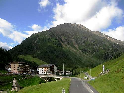
Towering 1500 m above Vent, the Talleitspitze is the first significant summit on the Kreuzkamm
By car you can reach Vent from the north, via Ötztal Bahnhof, or from the south, over the high Timmelsjoch. At night as well as from late fall to late spring the Timmelsjoch road is closed, and if there is a lot of snow it can be closed at any other time as well. For more information, see Timmelsjoch - Passo Rombo.
If the pass is closed, the alternative route from the south is a big detour over the Brenner to Innsbruck, and then enter the Ötztal from the northern side.
From Vent it's a two hour hike on a dirt road (no public motorized vehicles) to the Martin Busch Hütte, which lies right next to the mountain. The road is used by the staff of the hut, and you can have your pack transported up the road from Vent.
The Martin Busch Hütte can be reached from the south as well, but that takes much longer. Starting at the Vernagt Stausee (1690m) in Italy, hike up 1300m along a clear trail to the Similaun Hütte (3017m). This is the strenuous part. After that it's an easy 500m descent down the Niedertal valley to the northeast to reach the Martin Busch Hütte. Part of the trail is on the edge of the glacier (the Niederjochferner), but it's pretty flat and there are no crevasses near the trail, so no special gear is needed. And soon, when the glacier has receded just a little bit more, the trail no longer needs to go over it at all.
The route between the Similaun Hütte and Vent is part of a very long distance hiking trail, Via Alpina stage B32. The hut can be crowded.
Routes
 Brizzisee, with Westlicher Marzellspitze and Similaun in the background Brizzisee, with Westlicher Marzellspitze and Similaun in the background | 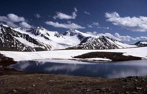 The same lake, June 2002, with a lot more snow high on the mountains The same lake, June 2002, with a lot more snow high on the mountains |
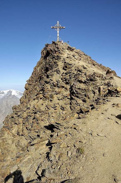
Final ridge to the summit
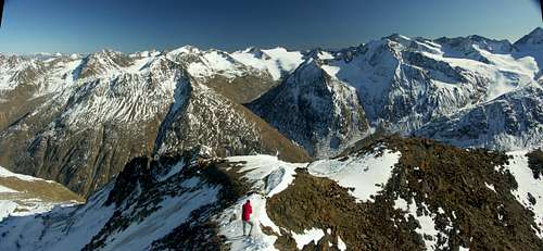
Summit view along the Kreuzkamm to the SW.
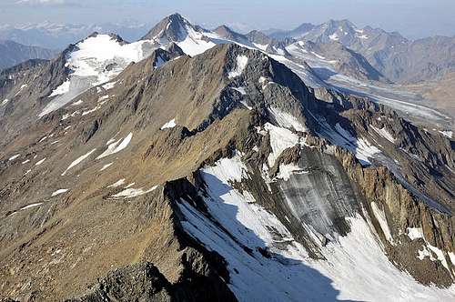
The Kreuzkogel (3340m) is the first summit on ridge, with the aesthetically pleasing ridge coming from the right and the small glacier hugging its northern slopes. Directly behind and a bit higher is the Sennkogel (3398m). The glaciated mountain further away to the left is the Hauslabkogel (3402m), the last summit on the Kreuzkamm.
Normal route
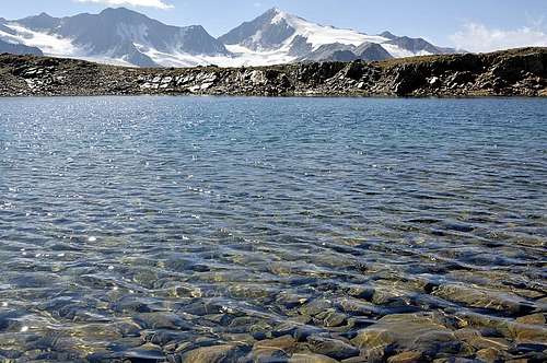
From the Martin Busch Hütte (2501m), a clearly marked trail to the northwest leads to the summit (2½ hours).At first the trail ascends steep grassy slopes, until it levels off around 2900m. There are a couple of small lakes in this area, the largest one being the Brizzi See, formerly known as the Samoar See (See is German for lake). This is a great spot for a picnic.
Past the lakes it gets steeper again, all the way to the summit now. Higher up you may encounter snow fields well into summer. The final short stretch the trail follows a somewhat exposed ridge (for a hiking route).
Summit view to the NE, to the Talleitspitze

The summit
SW ridge
On the Kreuzkamm, the next (minor) summit SW of the Kreuzspitze is the Kreuzkogel (3340m). From the Kreuzscharte (3254m), the saddle between them, it is a short climb to the Kreuzspitze, UIAA grade II.The Kreuzscharte can be reached either from the west or the east. For the latter, the first section of the route is the same as the normal route. At the level area with the lakes, leave the clear trail and go cross country, aiming directly for the saddle (compass heading ±300º). From the saddle, you can also easily get to the Kreuzkogel.
From the west, there is no trail to the Kreuzscharte either, and, as illustrated by the image above, the last part to the saddle is glaciated.
NE ridge to Talleitspitze
The ridge to the northeast, to the Talleitspitze, is an alpine route, partly on the glacier, mostly on (poor) rock, UIAA grade III.Red Tape
None.When to Climb
Summit view to the east on a fine october day
Best from mid June to September. If there is more than a little snow, it can turn into an alpine route, but in the right conditions it can still be climbed well into fall.
Ski season
The Kreuzspitze can be climbed with skis in winter and spring, but it is pretty steep. Avalanche risk can be high, especially in winter. Best ask in Vent or in the hut about current conditions.
Accommodation
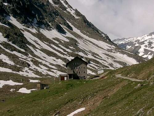
Martin Busch Hütte
The Martin Busch Hütte is perfectly located if you're on more than a day trip. During the day it's quiet enough, but around dinner time it can be a busy place. The food is good and the staff is very friendly.
One such busy evening, when I asked for seconds after what I have to admit was already a big meal, they improvised quickly. I owe them a couple of eggs now - if you happen to pass by, could you please bring them a few on my behalf?
The refuge is open in summer, serving mostly hikers, a few mountain bikers and the odd climber, and in the spring season for ski touring enthusiasts. Normally the winter room is open when the refuge is closed.
External Links
- Steinmandl.de
Route description with pictures (in German)

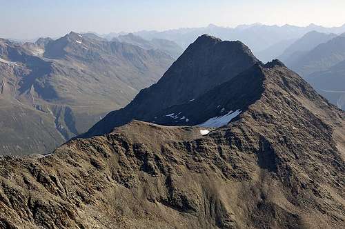
Northern half of the Kreuzkamm, seen from the southeast, high on the Mutmalspitze.
Some of the high peaks of the large Weißkamm area pop up behind the Kreuzkamm, most notably behind the Talleitspitze.