
-
 4142 Hits
-
 78.88% Score
-
 10 Votes
|
|
Mountain/Rock |
|---|---|
|
|
47.31977°N / 11.28294°E |
|
|
Hiking, Skiing |
|
|
Spring, Summer, Fall, Winter |
|
|
6893 ft / 2101 m |
|
|
Overview
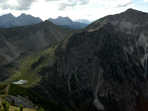
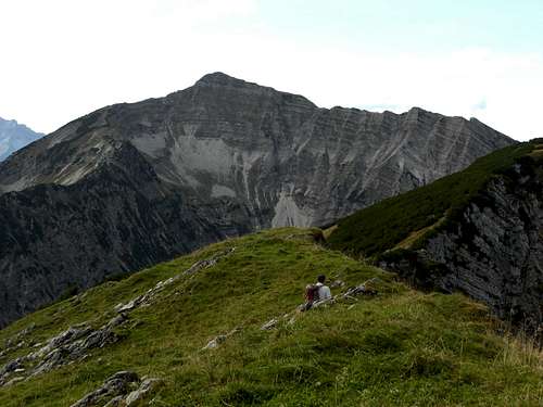 Schafreiter as seen from Torjoch
Schafreiter is the highest peak of Pre Karwendel mountains. It is a broad and high ridge – shaped summit, clearly dominating its surroundings and visible from all geographic directions. The views from this summit are likewise good. To the south Karwendel main ranges show their impressive rock faces. To the north the whole Pre Karwendel and the Bavarian Alps stretch to your feet. Ammergau Alps and Wetterstein range are visible to the west whereas to the east Brandenberger Alpen, Tuxer and Kitzbüheler Alpen and, in the far east, Chiemgauer Alpen and Berchtesgadener Alpen show their innumerable peaks and summits. The denomination of the mountain means: clearing for sheep and not: sheep - rider. There exist different spellings of the name: Schafreiter, Schafreither, Schafreuter, Schafreuther, even Scharfreither. All these –reuter and –reiter derive from the old German word: "Geräumt", which means clearing in the woods. The endings –kreut, kreuth, -kreit or –kreith have the same meaning. In summer and autumn Schafreiter is a main target for hikers. With the nearby Tölzer Hütte for accommodation you can combine several summits to a two days round trip. In winter and spring Schafreiter is a classic and one of the most frequented ski tours in the whole Northern Limestone Alps. On sunny weekends there are hundreds of ski mountaineers on the top of that peak. Thanks to a forest road built in the 1990ies from Riß valley up to the southern Alm meadows of Schafreiter, the ski route becomes more accessible and more popular. Consequently the downhill routes seem to be more a ski run than untouched powder or corn snow. But the route has low avalanche danger and nice “free style wood traverses” which adds enormously to the fun. Many good reasons to summit this peak despite of its popularity.
Getting There
 Schafreiter summit view to the southwest
Trailheads for Schafreiter are Riß valley Fall / Sylvenstein lake Sylvenstein lake is a dam lake and Fall was built up new on the lake shores as old Fall villages was on the bottom of the former valley. With low water you still can see the ruins of old Fall village. You reach Fall
Leave road number 307 at the signpost “Fall”, cross the village on Dürrachstraße in southern direction until you arrive at the hiker and overnight parking areas at the beginning of Dürrach valley forest road. Riß valley is accessible from Vorderriß, the end of road number 307, west of Fall. Follow the signposts “Eng”, proceed on that road for about 2,5 km. You then reach the parking area for the Moosenalm route / Reitsteig. 1 km further on after “Oswandhütte” inn there is the parking area for the ski route / direct route. Another 3 km further on brings you to the parking area for Lecktal trail. It is the first parking area after the supply cablecar for Tölzer Hütte.
Routes Overview
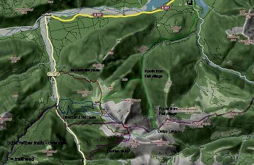 Schafreiter hiking and ski routes
Moosenalm route Start at the first parking area and follow Reitsteig (trail number Re) to Moosenalm and and follow trail number 237 to the trail junction with the direct hiking route and ski route. Go straight on and traverse the west and southwest slopes of Schafreiter to reach Tölzer Hütte. Take the left hand trail and ascend steeply, the last part following the southeast ridge to the summit. Alternatively take the left hand trail after the trail junction with direct trail at the following trail junction and ascend to Kälbereck, a secondary summit at the beginning of the long northwest ridge. Follow the ridge up to the summit. All these trails have the number 237! Direct route Direct route starts at the parking area after Oswald Hütte inn. Follow the old trail (not marked!) or the forest road up to the trail junction with Reitsteig near Moosenalm. From there go on as described above.
 Schafreiter ski ascent Schafreiter ski ascent |  Schafreiter ski ascent Schafreiter ski ascent |  Schafreiter ski ascent Schafreiter ski ascent |
Ski route The ski route uses the forest road up to the switchback at 1380 m height. Leave the road there and aim for the clearing in front of you. Zigzag up that clearing; in the upper part of the clearing near the northwest ridge go right to a secondary ridge. After that ridge ascend right hand slowly to the northwest ridge and follow the ridge to the ski summit. Leave your skies there and follow the last rock part of the northwest ridge to the summit. Downhill Schafreiter: Downhill use the same route (avalanche secure) or ski down the southwest slope halfway back to the secondary ridge. At the lower end of this excellent slope ski right hand into the woods and traverse the woods until you reach the ascent clearing. Ski down the clearing and the forest road. Lecktal trail At the Lecktal parking area, some 500 m behind the supply cableway to Tölzer Hütte, follow the trail number 239 up to Tölzer Hütte and the above described summit trail via southeast ridge.
 Near the summit Near the summit |  Summit west ridge downhill run Summit west ridge downhill run |  Summit block and southern view Summit block and southern view |
Trail / route from Fall From the hiker parking area at Fall follow the forest road about 800 m alongside Sylvenstein lake. Take the second righthand forest road (marked first with number 3, then with red marks) to enter Krottenbach valley and follow this road until its end. Shortly after that end there is a trail junction: The right hand trail leads you up to Klause, Klausenloch and Moosenalm. Pay attention: at the lower Moosenbach Alm clearing leave the unmarked trail which continues on your left, and go straight up off-trail to meet the trail number 237 at Moosenalm. At Moosenalm follow the above (Moosenalm route) described trails to the summit. The left hand trail (red marks) follows Krottenbach valley to its upper end at Delpsee. Take the right hand trail number 239 which ascends to Tölzer Hütte and follow the summit trail via southeast ridge. Combine the two alternative Fall routes to a long and interesting traverse. This is the longest hiking route and maybe the loneliest one for Schafreiter.
Red Tape & Accommodation
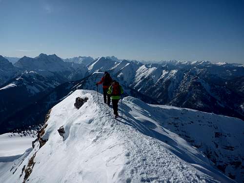 Descending Schafreiter summit
Red Tape
The Austrian part of Schafreiter – the summit ridge crest is the border between Germany and Austria – is part of Alpenpark Karwendel , an important National Park of Tirol.
The Bavarian part of the mountain belongs to the nature protection area „Karwendel und Karwendelvorgebirge”, which covers nearly the whole German Karwendel area.
The entrance is free.
Please respect the following rules in the National Park:

Accommodation
You find hotels, bed & breakfast and other accommodation at Fall A part of the Fall parking areas is reserved for motorhomes overnight stay. Lenggries Hinterriß Vorderriß Mountain huts Tölzer Hütte
Gear & Mountain Condition
 Schafreiter, Delpsjoch, Delps lake and Tölzer Hütte
Schafreiter is a year round summit. In late spring, summer and autumn it is an easy hikers summit. You need hiking gear and good shoes. The ski route is an easy one, too, as you use the forest road in the lower part with dense woods and ascend on the mostly moderate grade slopes up to the broad summit ridge. In winter and spring you need full ski tour gear and your avalanche gear. Schafreiter is a great snow shoe tour, too. Please stay away from the ski ascent track. Check the Tirol avalanche bulletin or the Bavarian avalanche bulletin before you get started. Current Weather:
Maps & Guide Books
Maps
Alpenvereinskarte Bayerische Alpen, scale 1 : 25.000, number BY 12, Karwendelgebirge Nord, Schafreiter, trails and ski routes, with UTM grid, München 2010 Bayerische Topographische Karte, scale 1 : 50.000, map number UK50-51, Karwendel, Landesamt für Vermessung und Geoinformation Bayern, 2008, with UTM-grid for GPS
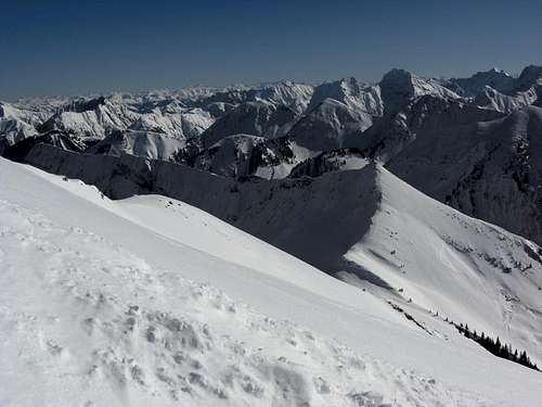
 Schafreiter as seen from Eiskarlspitze Schafreiter as seen from Eiskarlspitze |  Schafreiter as seen from Torjoch Schafreiter as seen from Torjoch |  Schafreiter winter summit view Schafreiter winter summit view |
Guide Book
Heinrich Klier, Fritz März, und Walter Klier: Alpenvereinsführer Karwendelgebirge alpin, Bergverlag Rother, 2005