|
|
Mountain/Rock |
|---|---|
|
|
38.49507°N / 109.62013°W |
|
|
San Juan |
|
|
Trad Climbing |
|
|
Spring, Summer, Fall, Winter |
|
|
4200 ft / 1280 m |
|
|
Overview

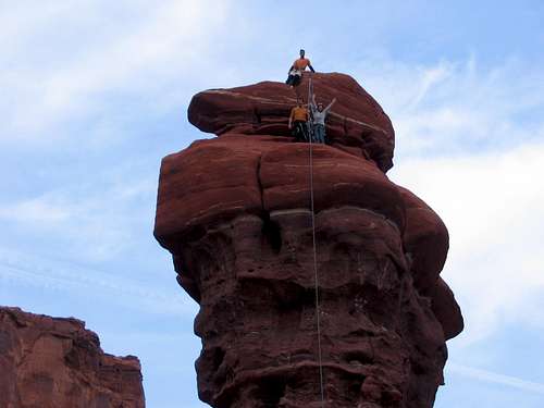
The Predator is a sleek-looking, 140-foot tower in the Kane Creek Valley. It is composed of a layer of poor quality, Cutler-like (think Fishers) sandstone at its base with a more solid band of stone above and a somewhat crumbly summit “bulb”. Two routes have been established (& published) on this formation (see below). By its easier line, Predator offers a nice way of spending a half day (or less). Summit views include the wide expanse of Kane Creek Valley as well as other small towers including Pensive Putterman and Devil's Golf Ball.
Getting There
 Predator
From US 191 in downtown Moab, turn west onto Kane Creek Blvd. near the McDonalds. In a couple miles, the road reaches and shadows the Colorado River (side opposite to Wall Street). The pavement will end and you will pass the Cirque of the Climbables just after leaving the Colorado River (at Kane Springs), the Ice Cream Parlor, and eventually The Predator tower (a quarter mile away on the right). The valley opens up before The Predator (~2 miles from Kane Springs) tower. At this point, look for the formation on your right (west side of road) and approximately 0.5 mile from the road – spire sits ahead of a parent ridge. Park at any wide pullout. Hike down into the bushes, cross the stream, and bushwhack another 50-100 yards. Once out of the bushes, the tower should be visible across the mostly flat meadow. It’s a quick hike from here – avoid trampling the crypto soil of which there are significant patches closer to tower.
Red Tape
None. This is BLM land. Tread lightly avoiding crypto soil and drive ONLY on established roads/tracks.
Camping
Many established and primitive campsites are available in and around Kane Creek Valley. Specifics (taken with permission from Dow's Ice Cream Parlor page - thank you!): Campgrounds are maintained by BLM’s Moab field office and cost $5 per vehicle. They have high end pit toilets, are open all year and have fire rings. Individual Campsites are available on a first-come/first-served basis. No reservations are accepted. Established: (1) Kings Bottom Camping Area = Kane Creek Rd, 2.8 miles from Hwy 191 (2) Moonflower Camping Area = Kane Creek Rd, 3.0 miles from Hwy 191 (3) Hunters Canyon Camping Area = Kane Creek Rd (dirt road access), 7.8 miles from Hwy 191 (4) Echo Camping Area = Kane Creek Rd (dirt road access), 8.0 miles from Hwy 191 Primitive: Kane Creek Crossing - there are approximately 28 sites located along Kane Creek where the Kane Creek Road crosses the water. These sites are free, but campers are required to carry out all garbage, including solid human waste. No wood cutting is allowed.
Mountain Conditions
Local climbing information can be obtained from the friendly folks in the local climb shop, Pagan Mountaineering located in Moab, UT. Their number is 435-259-1117. Also check: Moab Climate Summary Page. Moab area web-cam.
Routes And Guidebooks Overview
 Reign Of Terror
 Rain Of Dust
There are two routes on this formation that have been published in guidebooks: Reign Of Terror 5.11- or 5.9 C1 (2 pitches). Cameron Burns (Selected Climbs In The Desert Southwest ISBN 0-89886-657-X) and Eric Bjornstad (Desert Rock III: Moab to Colorado National Monument, ISBN 1-56044-754-0) guidebooks both give descriptions for this line. Rain Of Dust 5.11+ (3 pitches). Only Bjornstad’s guidebook (see above) lists this crumbly (at start at least) looking line.
External Links
Predator Tower page on mountainproject.com. TR on piquaclimber.com ....wait a minute, that look familiar??