

-
 17016 Hits
-
 83.69% Score
-
 17 Votes
|
|
Mountain/Rock |
|---|---|
|
|
46.32921°N / 7.22141°E |
|
|
Mountaineering, Scrambling |
|
|
Spring, Summer, Fall, Winter |
|
|
10246 ft / 3123 m |
|
|
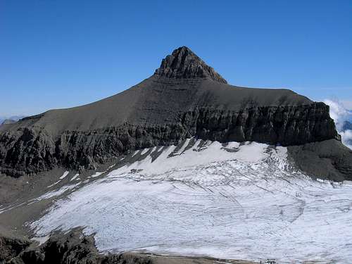 Oldenhorn classic view from the west (Sex Rouge)
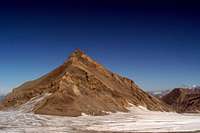 From the south
Overview
 From the SE
The Oldenhorn (Becca d' Audon) is a picturesque peak located near the far western end of the Bernese Alps. Its summit is the common point of Cantons Bern, Valais, and Vaud. It is believed that the peak was climbed as early as 1811. It was certainly climbed by a survey party in 1835. The summit is recommended for its impressive views. The East Ridge Route is included as part of a round tour including Les Diablerets (3209 m) and Tour St. Martin (2908 m) in "Berner Oberland, Die 100 Schoensten Touren" (The 100 Finest Routes in the Berner Oberland) by Grossen and Rebuffat.
Getting There
 Area map - click for larger image
The easiest approach is from Col du Pillon or Gsteig / Reusch via cable car to Sex (Scex) Rouge. You can also approach from Col du Sanetsch (You can get there by cable car from Gsteig or even by car from Saviese). Its a 2 hour hike through what the Tsanfleuron glacier left behind when it grew smaller: A wide, wild area of rocks, ponds, valleys and swiss army grenade ammunition. Link to area information including driving instructions, bus and train connections and cable car schedules: Glacier 3000 Panorama Map showing cable cars and local geography. Topographic map (Swiss-Geo)
Routes Overveiw
There are five main routes on the Oldenhorn. The easiest and safest is the East Ridge which is an easy walk up and recommended spring ski tour. Information is sketchy regarding the others. The rock on the mountain is generally poor quality for rock climbing. East Ridge About 2 ½ hours from the Cabane des Diablerets or Sex Rouge. Ascends the relatively gentle ridge crest without difficulty. Rated L (F). South Flank About 2 ¼ hours from the Cabane des Diablerets. The route follows a couloir through the cliffs and joins the East Ridge below the summit. Some of the climbing described as difficult over steeply sloping plates. Southwest Ridge About 4 hours from the base of the ridge. Involves a difficult overhanging chimney. West Flank About 2 hours from the Cabane des Diablerets Ascends a couloir directly below the summit and joins the Southwest Ridge. Rated S (D). North Ridge About 2 ¼ hours from the Cabane des Diablerets. Mixed climbing with a difficult chimney. Rated S (D).
Red Tape
Check first to see if the Swiss army is using the Tsanfleuron glacier for grenade training.
Huts
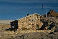 Cabane de Prarochet
Cabane des Diablerets SAC, 2486m. 5 min. below the cable car station "Cabane" of cable car "Glacier 3000." 80 sleeping places, 25 in winter. phone:+41 (0)24 492 21 02 Guardian: B. Lador, 1885 Chesières. phone.: +41 (0)24 495 37 28, mobile: +41 (0)79 213 57 86 Cabane de Prarochet SAC, 2555 m. 2 1/2 hours. from Col du Sanetsch, 1 1/2 hours below cable car station "Rouge". 44 sleeping places phone: +41 (0)27 395 27 27 Guardian (key depot): E. Léger, 1965 Savièse. phone: +41 (0)27 395 13 66
Mountain Conditions
Maps
"Les Diablerets", Swiss national maps, 1:25000, no.1285 , ISBN: 3-302-01285-3