-
 39262 Hits
-
 89.57% Score
-
 30 Votes
|
|
Route |
|---|---|
|
|
45.85730°N / 6.88709°E |
|
|
Ice Climbing |
|
|
Spring, Winter |
|
|
Half a day |
|
|
II D+, 350m, ice up to 80° |
|
|
Overview
This page will be kept in honour of the SP member Rahel Maria Liu, the former owner of this page, died on 25 August 2004 on the Innominata Ridge (Monte Bianco) at the age of 34.
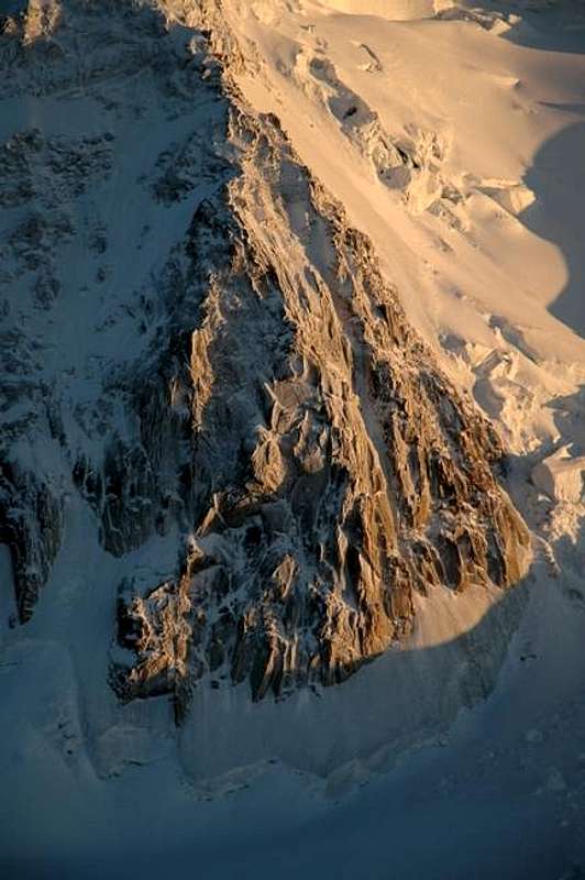
Chèré Couloir (Triangle du Tacul)
The Chèré Couloir is the classic ice gully of the Mont Blanc du Tacul North Face, which is also known as the Triangle du Tacul. The route is popular and you should pay attention that not too many people are above you because of the danger of falling ice and other debris.
Since the route is North-facing it can generally be climbed throughout the year. During winter it's a tough but wonderful ice-climb with very good ice, but the risk of getting serious frostbite is significant! Sometimes it's about -30°C while climbing during winter.
The Chèré Couloir is shown as route G in the following overview photo:
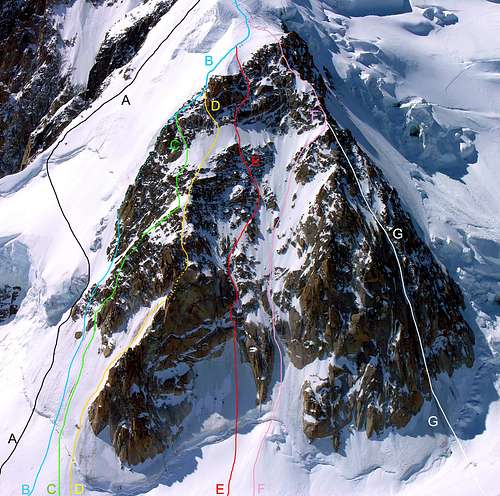
|
|||||||||||||||||||||||||||
Approach
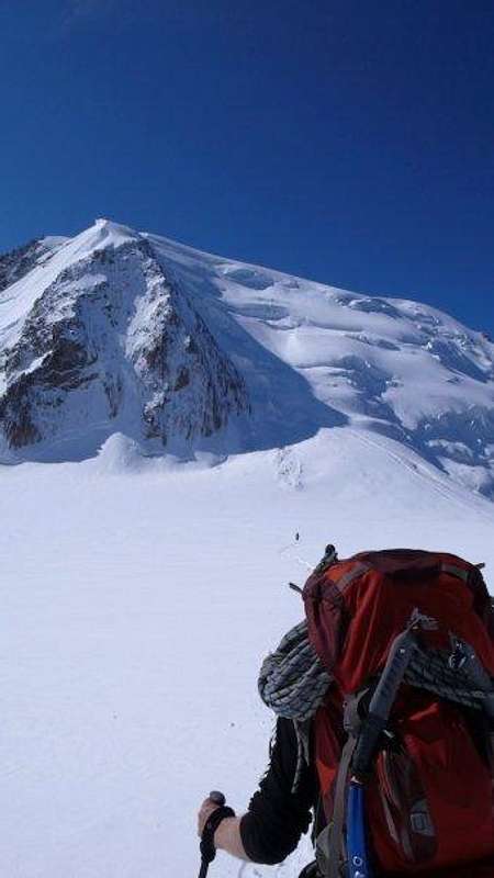
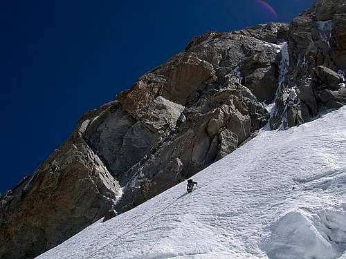
Catch the Telepherique de l'Aiguille du Midi from Chamonix in the morning or start from either the Cosmiques Refuge or Abri Simond bivouac (in winter). The base of the Triangle du Tacul is reached by an easy walk across the Col du Midi.
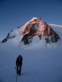
 Descending from the Aiguille du Midi station |
 Approaching the Triangle du Tacul |
Route Description
The Chèré Couloir is a very slender couloir which goes up in the very right part of of the triangle.
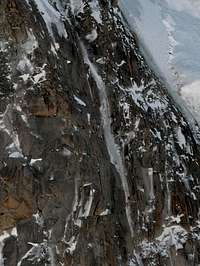 Chèré Couloir overivew |
 View from the bottom |
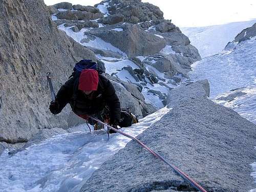
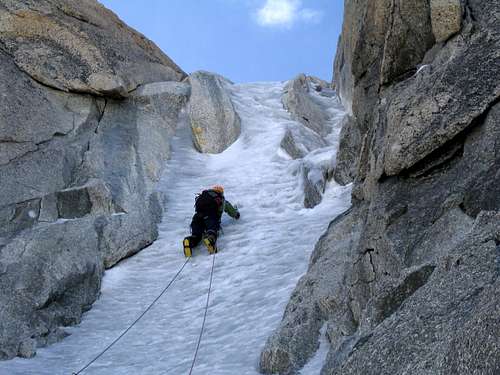
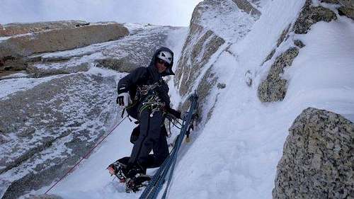
After having passed the bergschrund, you climb to the first steep step. The ice becomes steeper and steeper (at the beginning 60°, then 70° and 80°). After a less steep passage, you have to climb over the second very steep passages with 75°. At the end, you climb on the right side of the mixed ridge until you reach the end of the triangle.
Many parties only climb the first 5 or 6 pitches, which are the steepest, and then abseil the route by the same way. Most of these initial pitches have in-situ bolted belay stations.
Descent

From the end of the rock at the apex of the Triangle du Tacul (3970m) there are various options for descent, and the best choice will depend on the snow and serac conditions on the NW flank, which can be a bit treacherous at times - due caution is advised!
- From the apex of the triangle descend the NW Slope (150m, max 45°), which is directly adjacent to the rock on the W side. Abseils and/or down-climibing may be required. (see route 187. in "Snow, ice and mixed.")
- Ascend the North Ridge above the triangle and then traverse to the right into the NW flank of Mont Blanc du Tacul underneath the highest band of seracs to join the Normal Route.
- Ascend the North Ridge as far as the summit of the Mont Blanc du Tacul and then descend by the Normal Route.
Finally:
- It is possible to abseil the Chèré Couloir, which has much fixed gear and several in-situ belay stations (especially for the lower pitches). Be aware, however, that this is a popular route and the safety of other parties should be respected. Don't drop rocks, ice, ropes, or similar onto their heads! Double 60m ropes are recommended for the abseil descent.
Essential Gear
Two technical axes, a few ice screws and some rock protection. Double 60m ropes are recommended if you plan to abseil the route.
Accomodation
Chamonix is a primary destination, offering various kind of accomodation (hotels, huts, gites, renting rooms). Numberless campsites are situated both in the Northern and Southern ends of the town. Main campsites:
- Camping la Mer de Glace - Les Praz (3 km. North to Chamonix) +33(0)450534403
- Camping les Deux Glaciers - Les Bossons (3 km. South to Chamonix) +33(0)450531584
- Camping les Arolles - close to the centre of Chamonix - +33(0)450531430
- Camping les Cimes - Les Bossons (3 km. South to Chamonix) +33(0)450535893
- Camping les Marmottes - +33(0)450536124
- Camping Glacier d'Argentière - Argentière (8 km. North to Chamonix) +33(0)450541736
General info
- Office de la Haute Montagne de Chamonix Phone +33 0450 532208 Office de la Haute Montagne
- Cable-car informations Phone +33 0450 532275 Compagnie du MontBlanc
- Office du Tourisme de Chamonix Phone +33 0450 530024 Chamonix Mont-Blanc
Meteo and mountain condition
You can get excellent information about weather, conditions and routes at the "Compagnie des Guides de Hauts Montagnes" (cieguides-chamonix.com, tel: 50 53 00 88) or the "Maison de la Montagne" at the "place de l'Église" in Chamonix. Don't be afraid to step into their building, its common practice, people are constantly walking in and out. By no means you are expected to hire a guide when you visit. For weather reports you can call 50 53 03 40. In winter the number 50 53 17 11 gives snow conditions and avalanche risks. Mountain rescue is secured by the "Gendarmerie de Haute Montagne", 50 53 16 89
Guidebooks
- "Snow, ice and mixed. The guide to the Mont-Blanc Range.", Volume 2, François Damilano, JMEditions, 2006. (A French edition is also available)
page 116, Route 190., Chèré Gully, II 4. 350m. - "Mont-Blanc-Gruppe: Gebietsführer für Bergsteiger und Kletterer.", Hartmut Eberlein, Bergverlag Rother, August 2005, 10. Auflage.
80° (short passage), 1 rope length 70°, the rest 50° to 60°, D+, short, but interesting couloir, frequently climbed, 300 hm, 3-4 h
Acknowledgement
![Jonction-Ice-Break on the way...]()
Jonction-Ice-Break on the way... -
The last maintainer of this page and early SummitPost member Rahel Maria Liu died for hypotermia on 24/25 August 2004 after being caught in a freak snowstorm while attempting to climb the Innominata Spur on the southern (Italian) side of Mont Blanc. Edward Allen, her climbing companion (a British climber known some days early), was saved by an helicopter of the Italian Rescue team. Rahel was a charter member during SP's early days, and her work here remains among the best of SP's collected contributions. Her knowledge and experience has made an impact on the world mountaineering community, and her warmth and friendship will be long remembered among her many friends and fellow members here at SummitPost. She will be greatly missed by us all. She was only 34 years old. Continued maintenance of this page is in her memory.