
|
|
Route |
|---|---|
|
|
19.01640°N / 97.2667°W |
|
|
Mountaineering, Skiing |
|
|
Winter |
|
|
Most of a day |
|
|
Scramble/Moderate Snow |
|
|
Approach
See main text. Start at the Piedra Grande hut from which most of the route is visible. This is the same start as a few other routes and the only hut left on the mountain.
Route Description
The first couple thousand feet of the climb is on a rough trail. The trail starts out near the hut, follows the aqueduct, then climbs further up the ravine. Although it begins well-marked, the trail becomes a network of winding social trails further up. At night this is confusing but climbers should be okay as long as they continue upward without doing something stupid like accidentally climbing the sarcofago.
Experiences transitioning to the glacier can vary depending on which of the paths was taken. In most cases simply stepping over from rock to snow/ice is all that is necessary. In the case of climbers who stayed on the very bottom of the ravine there might be some boulders and short stretches of low-moderate angle water ice to cross.
On the way down in daylight the trip is very easy.
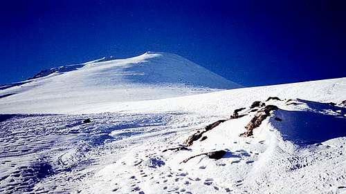
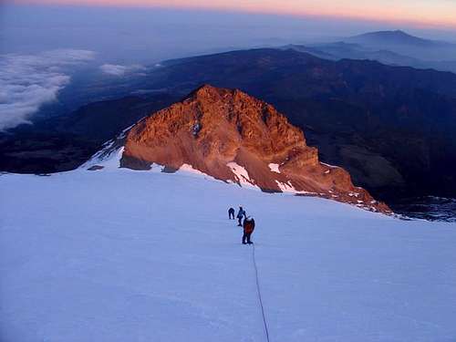
From the start of the glacier the route is very straight-forward or should I say straight up. At about 17,500 ft the glacier steepens to about 40 degrees. A few hundred feet higher and your at the crater rim near the aguja de hielo or ice needle. Follow the rim to the right to the summit.
 A rope for piece of mind
Crevasses
A frequent question concerning this route is regards to any crevasse danger.
Yes, there are crevasses. In my experience, and the experience of climbers I have personally talked to, nobody has seen a crevasse wider than a few fingers on this route. Reportedly people have managed to find a crevasse to fall into but details are vague. Perhaps decades ago there were dangerous crevasses. If you can provide any additional information please post it here.
Essential Gear
Crampons and ice ax. This route is commonly done without standard glacier travel/rescue gear. Note that it can ice up and have fall potential. It is important to get information on current conditions because some climbers do decide to take a rope and a few screws and even use them.
A rope for piece of mind
marke - Dec 10, 2003 5:07 pm - Hasn't voted
Route CommentWe summited Pico de Orizaba in late November of 2003. In gathering beta at Piedra Grande we did not find any information on the "Tongue". To the best of our understanding, it seems that most of this snow has melted out over the past couple of years. The new technical crux of the climb is left of where the Tongue used to exit the glacier and is called the "Labyrinth". It is a mixed section of rock and ice gullies. With carefull route finding, this can be kept to a relatively easy class 2 hike. However, it can quickly become more difficult. If it seems to be getting more technical, back up and look for another route, there are many ways to work through this area. I will include a picture of this section.
Alpinist - Mar 26, 2005 5:13 pm - Voted 10/10
LabyrinthHere is a photo of the Labyrinth showing the easiest route. We met a guide at the hut that drew us a map of the best route through the Labyrinth. He said to avoid the chutes going up the right side of the Labyrinth because they get steeper and more technical near the top of the ridge. During our acclimitization day, we explored the Labyrinth and confirmed what he told us. Aim for the low point on the left ridge, just to the right of the white rocks and (seasonal) waterfall. As you get closer, you'll see a large boulder on the top of the ridge. This is your target. There is a very good trail and markers the whole way. If you stay on route, it is very easy. The only problem is that there are multiple trails with markers that go up the other chutes. Why those other trails are marked with wands and ducks, I don't know. The right-hand chutes are much more technical than the route that crosses over to the left side.
jklloyd81 - Feb 16, 2016 3:09 pm - Hasn't voted
Update: Crevasse DangerFrom a climb on February 8, 2016: Numerous small crevasses can be found on the normal route. Much of the surface snow was gone when I climbed Orizaba, so I got a fairly good look at the crevasses. Lower on the glacier, there were some tiny cracks and one rift perhaps a foot wide. At 18100 feet, I broke though apparently solid surface and fell 8 meters to the crevasse floor. The crevasse is at least 3 meters wide and 100 meters long--I did not probe the ice-black depths of the crevasse and do not know exactly how long it is. This is likely the bergschrund of the glacier, given its size, proximity to the summit, and the concentration of rock on one of its walls. Please be advised that Orizaba does indeed have great crevasses--I just spent the night in one. For obvious reasons, I recommend climbers who visit Orizaba do so as part of a rope team.
big_g - Feb 16, 2016 9:55 pm - Hasn't voted
Re: Update: Crevasse DangerWow, glad you got out of there to share your story.
wallybipster - Apr 12, 2016 10:23 pm - Hasn't voted
Crevasse Danger Cont...I just got back from my first Orizaba climb, and I'm glad we roped up. We crossed about 5 crevasses. Some were small, but we poked around a few of them and found them to be sketchy enough for potential entrapment, including one doozy that appeared to be 6 meters deep or so. They were all located on the upper third of the remaining glacier, on the steeper grades, I didn't see any signs of crevasses on the mellower, lower slope.