
|
|
Route |
|---|---|
|
|
44.16080°N / 71.6444°W |
|
|
Hike |
|
|
A long day |
|
|
Class 1 |
|
|
Approach
SKOOKUMCHUCK TRAILHEAD: (1700')From I-93 get off at Exit 36 toward Twin Mountain (U.S. Route 3). Stay on Route 3 not more than a mile. The trailhead will be on your right. The Parking Area also serves as the parking area for the Franconia Notch State Park Bike Path. The Skookumchuck Trail leaves on the Northeast corner.
Route Description
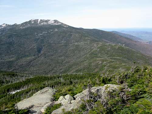
Mt. Lafayette. You can basically see the Garfield Ridge trail as it works it way to Mt. Lafayette
GARFIELD RIDGE TRAIL: (0.8 MILES)
TOTAL HIKE: 10.2 MILES
This is a much different way from the Franconia Ridge Traverse, but in many ways just as scenic way of climbing Mt. Lafayette. It is much less crowded than the Franconia Traverse and a little longer as well. But as the Franconia Traverse climbs Mt. Lincoln, this way climbs the much less well known, but just as beautiful, North Lafayette, a large hump on the north side of Mt. Lafayette.
The trail leaves the parking area heading south toward the summit of Mt. Lafayette. It continues at a moderate grade to the edge of Skookumchuck Brook about a mile away. It continues up the brook until it reaches a set up very steep rock steps at 1.8 miles. These steps will take the wind out of you so be prepared.
From there the trail takes many alternating grade through the birch forest until you hit another hit a spring and another set of steps at 2.5 miles. The trail continues at a moderate pace with some small steeper sections through birch, spruce and then through thick scrub. Toward the upper elevation the trail narrows through the scrub. It continues to rise until at 3.6 miles it summits the shoulder of Mt. Lafayette. The trail then shortly drops then rises again where it rises above timberline and hits the Garfield Ridge Trail.
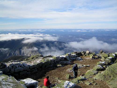
Take a right on the Garfield Ridge Trail. After hiking a steep pitch up to the top of the hump of North Lafayette (5,080') with its great views (some argue that North has better views than Mt. Lafayette) continue at a more moderate climb toward the top of Mt. Lafayette (5,260') where world class views await you.
hiking shoes , tons of water and essential hiking gear. Keep in eye on the weather though because Mt. Lafayette is above timberline and it can get very cold at any time of the year. In June bring tons of bug repellent due to black fly season. Your friends will know if you didn't by all the nasty bites you will be scratching the next couple of weeks.
I wouldn't advise this route in winter unless you had good crampons. Though the route is overall easier than Falling Waters (which I would also advise to have crampons), the section with the steep steps can be very hazardous when there is two feet of snow on top of them without some type of traction.
Take a right on the Garfield Ridge Trail. After hiking a steep pitch up to the top of the hump of North Lafayette (5,080') with its great views (some argue that North has better views than Mt. Lafayette) continue at a more moderate climb toward the top of Mt. Lafayette (5,260') where world class views await you.
Essential Gear
In summer and early fall nothing more is needed except forI wouldn't advise this route in winter unless you had good crampons. Though the route is overall easier than Falling Waters (which I would also advise to have crampons), the section with the steep steps can be very hazardous when there is two feet of snow on top of them without some type of traction.
Sam Page - Aug 26, 2007 10:23 am - Hasn't voted
ApproachIf you are heading south on the 93, after taking exit 36 you need to follow an access road for about one mile to get to route 3. When you intersect route 3, MAKE A RIGHT. The trailhead parking lot will then be on your LEFT in roughly half a mile. If you make a left on route 3, there is a parking lot on your right after about one mile. There is also an unmarked trail which starts at this parking lot. The directions on this site might lead you to believe that this is the Skookumchuck Trail, and although the trail might eventually intersect the ST, it is not the official trailhead.
pauljmattera@mac.com - Oct 13, 2019 7:27 am - Hasn't voted
careful of the trail on the descent from Lafayettei hiked this trail a number of years ago, in the summer, to the summit of LaFayette. The trail on the descent back to the parking lot takes a hard left turn. If your not paying attention you continue on the Garfield trail into the wilderness and far from your vehicle. We realized this only when we came across a pond. There was no pond on the trail we took up. As it was getting late we had no choice but to re climb Lafayette and then see if we could descend to the spend the night at the Greenleaf hut. We made it but needed assistance from a rescue team equipped with flashlights and provisions. Pay close attention to the trail on the return to your car.