

-
 17017 Hits
-
 85.87% Score
-
 21 Votes
|
|
Mountain/Rock |
|---|---|
|
|
45.85440°N / 6.90430°E |
|
|
Trad Climbing, Sport Climbing |
|
|
Summer |
|
|
11601 ft / 3536 m |
|
|
Overview
| A small, secondary summit in Tacul satellites. It is the last summit of the ridge coming down from Gran Capucin to NE. Wonderful rock, red on south face, big plates on east ridge, gray on the north face. Easy and confortable approach, can be climbed if weather is not good enough for big routes. The easiest way has passages of 5° (UIAA) If you are a quick climber in the same day you can also climb the Pyramide or the Petit Capucin 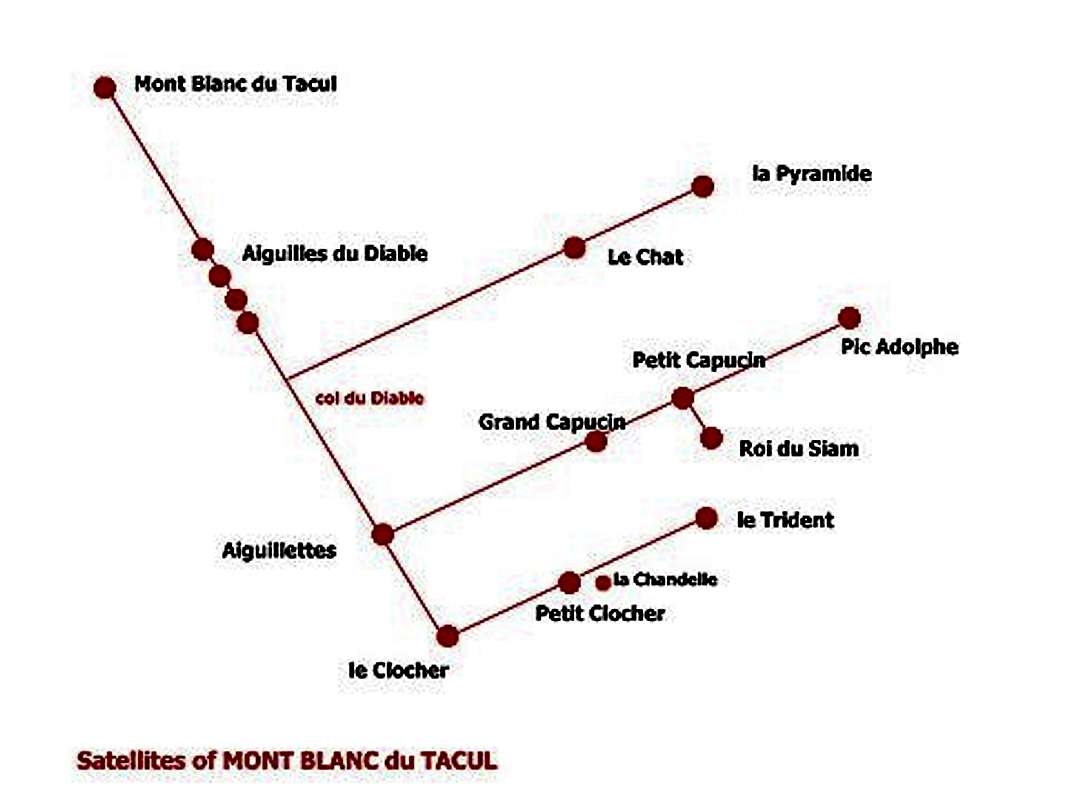
|


Getting There
| Can be done in one day starting directly - from Courmayeur (cable car to Punta Helbronner) - from Chamonix (cable car to Aiguille du Midi) All routes start from Glacier du Geant Starting point : Rif Torino - less than 1 hour using the route to Col du Gros Rognon - Col du Midi Rif Cosmiques - 1,5 hour passing the Col di Gros Rognon Rif du Requin - 2,5 hours through "la Bediere" and the Route to Col du Geant |
Routes
| WNW edge (Gamboni-Morel 1954) - short but difficult (V+, VI) - from breche du Pic Adolphe (easy from S) WNW ridge and N wall (Gervasutti-Chabod-Boccalatte-Pietrasanta 1935) - very strange route .... the first to be climbed N wall why try to climb here ? E ridge - south spur (Salluard-Busi 1951) - 300 m - EDinf - the most classic route - can be done in all the seasons if dry E ridge - north spur (Terray-Guillaume 1958) - 300 m - TD - looks like Rebuffat to Aiguille du Midi, little less difficulties but longer S wall - (Gervasutti-Panei 1943) - 250 m - to the right of central part of the wall - TD (1 pass VI) S wall - (Lorenzi-Rey 1951) - the big diedre - 250 m - ED inf (VI) SW wall - (Ottoz-Nava 1952) - 200 m - TD
|


Logistics and Huts
| Rif. Torino directly with the cable car from Entrèves/Courmayeur (Italy). You can reach the hut directly also with the Helbronner cable car from the Aiguille du Midi (to Aiguille du Midi with the cable car from Chamonix). Pay attention: The Helbronner cable car, traversing the Géant glacier, is mostly closed. Or you go on foot from the Aiguille du Midi over the glacier du Géant (3 h): From the foot of the S-face of the Aig. du Midi you go on the almost even glacier to the Pointe Lachenal, turn left (E) to the glacier valley below the rugged E-face of the Mont Blanc du Tacul. You go along this E-face of the Tacul and the Pointe Adolphe Rey in order to loose only little height. Now you turn to the ESE to the Col des Flambeaux. From here in a few minutes to the Ref. Torino. It is a very beautiful glacier walk with 200 hm ascent. Difficulty: F. Courmayeur (Italy) by bus or car: - from Chamonix through the Mont Blanc Tunnel from the NW. - from Milano or Torino (from the SE) on the A5 via Aosta valley Ref. Cosmiques: In about 1/2 h from the Aig. du Midi (cable car from Chamonix). If you leave the cable car station via the bridge, you go to the Southsummit. On the firn ridge, you go down with SE-direction to an even ridgeplatform; then turn right to the S and SW-direction below the S-face of the Aig. du Midi. Pay attention to crevasses! Chamonix Valley by train - from Martigny (Switzerland) via Vallorcine - from Geneva (airport) via Anncey (TGV till here) and St. Gervais. Chamonix Valley by bus: - from/via Annecy, Geneva, Grenoble, Courmayeur, Aoste and Turin Chamonix Valley by car: - from Geneva (from the NW) on the A40 till St. Gervais and from here on the N205.b. From Martigny (from the NE, Switzerland) via Vallorcine and the Col des Montets on the road no. N506. |
When To Climb
| All seasons, in winter or spring you must use ski to aproach it. North wall is often in bad conditions and hard to find dry even in summer |
External Links
- Interesting link for Pointe Adolphe Rey with nice pictures!
thank to Clarity for pointing at