
-
 97278 Hits
-
 90.26% Score
-
 42 Votes
|
|
Mountain/Rock |
|---|---|
|
|
18.10835°S / 68.88262°W |
|
|
Download GPX » View Route on Map |
|
|
21463 ft / 6542 m |
|
|
Overview
This page is under reconstruction!
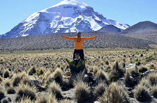
Presenting a magnificent Andean dream scape of snow capped volcanoes, soaring mountains, bubbling hot springs, bird-dwelling wetlands and vast wild plains, Bolivia’s oldest national park makes an exemplary location for photographers and adventurers alike.Located in the southwestern department of Oruro, Sajama National Park borders the province of La Pazin the north and Chile’s Lauca National Park in the west. Occupying the eco region of Puna, a high Andean plateau situated at 6,542 meters above sea level, the park is also part of the volcanic Cordillera Occidental, home to Bolivia’s highest mountain peak, Navajo Sajama.
Spanning an area of 1002 square kilometers, the extensive plains of the altiplano are prime grazing country for the park’s legion of vicuñas, alpacas and llamas. Many endemic plants and animals thrive within Sajama’s walls, making its continued conservation of great importance to both local and scientific communities. Established as a natural reserve in 1939, Sajama National Park has been home to Bolivia’s Aymara people for thousands of years. Unique artifacts,age-old burial sites, cave paintings, small adobe churches and mysterious lines dot the otherworldly landscape, demonstrating the incredible influence the ancient indigenous culture has had throughout the region.
Due to Sajama’s universal cultural and natural significance, in 2003 the park was added to the UNESCO world Heritage Tentative List. Renowned for its enchanting scenery, abundant flora and fauna, incredible trekking, andpre-hispanic archaeological sites ,it’s easy to see why Sajama National Park is one of Bolivia’s crowning jewels.
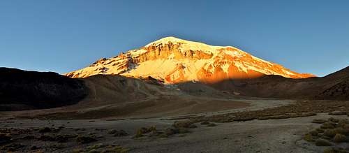
Sajama
Nevado Sajamais an extinct strato volcano and the highes tpeak in Bolivia. The mountain is located in the Oruro Department, Sajama Province, Curahuara de Carangas Municipality, Sajama Canton.Map of Curahuara de Carangas Municipality and population data .It is situated in the Sajama National Parkin the southwest area of the country some 16–24 km from the border with Chile. The peak is an isolated cone, but is geologically complex, with lava domes of andesitic and rhyodactic composition overlain by an andesitic strato volcano. The date of the most recent eruption is uncertain, although Holocene activity is assigned to the volcano by many. The treeline of Polylepis tarapacana on the volcano is as high as 5,200 m above sea level, one of the highest altitudes trees can be found growing anywhere in the world.
Joseph Prem made the first attempt to climb themountain in 1927 by the northwest ridge but was stopped short at 6,200 m. After several more attempts, Prem along with Wilfrid Kuehm reached the top in August 1939 by a more difficult southeast ridge. From the village of Sajama an acclimatised team can climb the mountain in two or three days if weather conditions are favorable. Currently the easiest of the routes is the SW ridge. This route is technically easy, require some minimal mountaineering equipment and does notpresent any particular difficulty except some snow slopes up to 45 degrees. In August 2001, two teams of Sajama villagers and Bolivian mountain guides played a soccer match on top of Mount Sajama in an effort to show that altitude itself is not a limitation to physical strain. Indeed, the objective was to protest against the FIFA decision to discontinue the use of La Pazas a location to hold international footbal lmatches, because of its very high elevation.
 |
 |
 |
 |
 |
Getting There
Road to Sajama
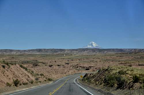
Road to Sajama
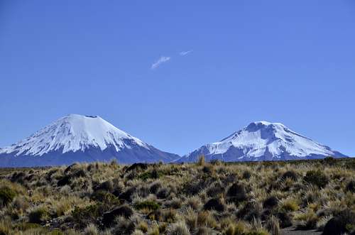
Cerros de Payachata
By Bus
As there are no buses travelling direct to Sajama, travellers must transfer in the small town of Patacamaya, a small truck-stop on the main road between La Paz and Oruro.
Please note: Buses don’t always run on a Sunday, so make sure to be flexible with your travel plans
From La Paz: Take an early morning Oruro-boundbus from La Paz’s Terminal de Buses to the town of Patacamaya, from where another minibus goes direct to Sajama Village (see detailsbelow). Buses from La Paz leave every 30 minutes and the journey to Patacamaya takes around 1.5 hours. A one way ticket costs Bs 10 ($1.50 US).
From Oruro: Take one of the early morning minibuses headed for La Paz getting off at Patacamaya. There are several departures per hour and the journey from Oruro to Patacamaya is around 2 hours. You will have to pay the full price to La Paz for the ticket which costs Bs 30 ($4 US) one way. From Patacamaya take a minibus to Sajama Village (see below for details).
Alternative route from LaPaz/Oruro: Take one of the several daily buses headed to Arica, Chile asking the driver to drop you off on the road leading up to Sajama. From this point you are still 12 km away from the entrance to the park, so be aware that you will either have to wait for a car to pass by to give you a lift into town, or walk the remaining distance(around 3 hours). Otherwise you can get off at the nearby town of Tambo Quemada from which transport to Sajama should be easy to find.
From Patacamaya: Take the 12 pm bus to Sajama, leaving from the north side of town in front of ‘Restaurante Capitol’. Thereis only one bus scheduled per day soit’s recommended that you start lining up as early as possible to secure a seat. The bus departs once full so it’s not uncommon to be waiting around until 1:30pm to hit the road. The journey to Sajama takes around threehours, costing Bs 30 ($4 US) for a one way ticket. There are no stops along the way so make sure to use the bathroom and buy snacks before heading off.
From Sajama: To get back to Patacamaya the bus leaves from the main plaza every day at 5:30 am (4 am on Sunday). You are required to be atthe bus stop 15 minutes before departure, so be sure to wear warmclothes as it’s very chilly at this time of the morning. The journey takes around 3 hours and costs Bs 25 ($4 US) for a one way ticket. From Patacamaya there are many buses travelling to Oruro and La Paz.
The other option is to organise a lift from Sajama Village to the main highway and wait fora bus coming from Arica to La Paz. Buses pass the crossroad around noon and usually stop for passengers along the road. Ask the locals in Sajama for more accurate times.
 |
Red Tape
No particular restrictions - no permit is needed, but as entering the Sajama National Park, you have to register at the Ranger station in Sajama village. You also have to pay a fee of about $2 (US dollars) to enter the park. The rangers can arrange anything for you there like transport, mules, guides etc. You are also required to fill in forms about what you intend to climb and when, what your experience is, what kind of equipment you are taking etc. They say they will come and look for you if you're not back within the time you mention in the forms. So do go back there on your way out again! New Information- important! Climbing Sajama from the Bolivian side is only allowed between April and October. This seems to be a new decree and also applies to all mountains in the Sajama National Park. More information to follow once I have checked this. Thanks to Nando for raising this point. Thanks also to Boris Krielen for supplementary information.When To Climb
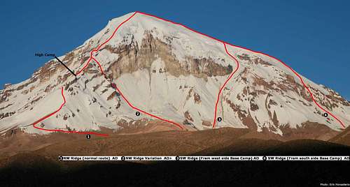
Routes to Sajama
 |
 |
 |
 |
 |
Camping
The area in which Sajama is situated is a national park (contact: +591 08135260) and you should treat it with according sensitivity. The area is very arid, with less than 90 millimetres annual rainfall. There is a great diversity of flora and fauna, none of which is likely to trample or eat you. Boris Krielen has this to say: Be aware when camping on the sand in the valley. There are dustdevils all the time which can turn into serious sandstorms. Sleeping in just a bivybag can be an unpleasant experience when it fills up halfway at night with the very fine black lavasand. It might take your breath away. |
 |
 |
 |
 |
Mountain Conditions
At over six and a half thousand metres, weather conditions can be severe. You should be equipped to deal with very low temperatures and high winds, plus localised storms. |
 |
 |
 |
 |
Other Information
Sajama was the unlikely location for the world's highest ever football match, at the second attempt, on August 2nd, 2001. See the report from the BBC here and a more complete account here. Make of it what you will, but don't try this at home! Check out Brankoi's account of his ski descent of the South West Ridge in the 'routes' section a the top left! |
External Links
- Ice-X Foundation Dutch climbing foundation promoting clean climbing. Lots of info about their expeditions (Elbrus, Aconcagua, Seven Summits), photo's, links etc. English version coming soon. e-mail: info@ice-x.nl
- Bolivia Adventure Planet Expeditions A travel agency that works in Bolivian's moutain ranges, Patagonia and Aconcagua. It provides the best guides and offers logistic support for all the expeditions.
- Bolivian Journeys Bolivia climbing specialists based in La Paz, expeditions and logistics throughout the bolivian Andes. www.bolivianjourneys.org mail:boljour@entelnet.bo
Corax - Sep 12, 2006 10:25 pm - Voted 7/10
Please changePlease change the coordinates of Sajama. They are far off the mark. Thanks, JC.
richardpattison - Jul 29, 2014 2:31 pm - Hasn't voted
5 min videoYou can watch a 5 minute video of the North West ridge here: https://www.youtube.com/watch?v=RthAYLkeq74
gimpilator - Sep 26, 2015 11:57 am - Voted 4/10
AdoptedI'm looking forward to seeing what you do with this page. Let me know when it's finished and I'll change my vote.
Senad Rizvanovic - Oct 6, 2015 3:18 pm - Hasn't voted
Re: AdoptedI'll let you know when i complete this project.