
-
 442807 Hits
-
 99.56% Score
-
 119 Votes
|
|
Mountain/Rock |
|---|---|
|
|
35.34640°N / 111.6778°W |
|
|
12633 ft / 3851 m |
|
|
Overview

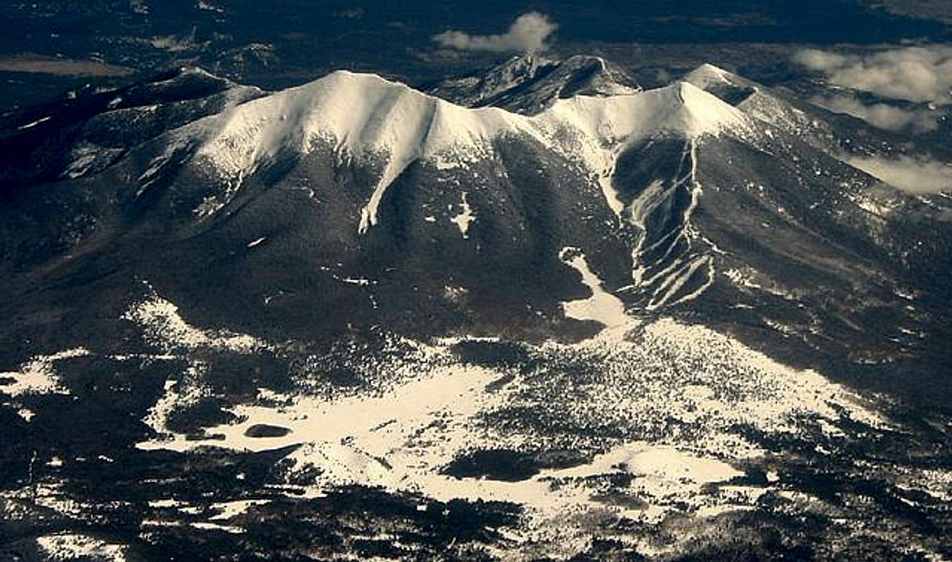
Humphreys Peak is the highest mountain in Arizona and resides in Coconino County, in the northern part of the state. It is the 26th most prominent mountain in the lower 48 states, rising over 6,000 feet. Humphreys Peak and the greater San Francisco Mountains is part of the Kachina Peaks Wilderness Area, which includes 18,960 acres.
Out of all the western states high points it is the easiest summit to hike. All the Guide books of hiking in Arizona will tell you that it is a strenuous hike, but compared to the rest of the western high points it's easy to moderate. The top of the peak seams to be out of place in Arizona, almost giving you the feeling you're not in Arizona anymore. It's often referred to as "Arizona's little Colorado."
Many people that don't know anything about Arizona have no clue that there are 12,000-foot mountains in the state. The popular misconception is that Arizona is a flat desert with no trees or mountains and certainly not worth visiting. The views from the top are tremendous. To the north you can see the north rim of the Grand Canyon, to the east, the White Mountains and Holbrook, to the south, the desert Mountains near Phoenix are visible. Local legend has it that the name, "San Francisco Peaks" have been named that because one can see the city of San Francisco, which is obviously not true. Humphreys Peak was named after General A. A. Humphreys who was a US chief of Engineers.
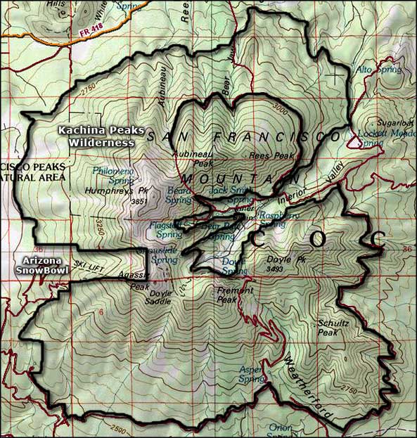
There are 2 main routes that lead to the top, The Humphreys Peak trail (mentioned below) and the Weatherford Trail. The Weatherford trail was once a road that allowed Model T Fords to get up to 12,000 Feet. There is also the Inner Basin trail that connects to the Weatherford trail, which starts at Locket Meadow.
The Humphreys Trail starts at the Arizona Snow Bowl. This is the standard approach. The trail is very well marked until you reach the saddle. The first 3 miles the trail gradually climbs the mountain, then the last 1 3/4 miles it gets steeper and more difficult. After the saddle the trail can be hard to find at spots near the top. There are posts added on the last 3/4 of a mile to help mark the trail. If you lose the trail look for the posts. It is very rocky and loose above 12,000 feet. The trail ascends 3 false summits before reaching the true summit. The trail is moderate to difficult, but anybody in some sort of shape can make it if you don't have any problems with elevation sickness. I've seen overweight people hike it to the top in horrible shape; it just took them all day. Total mileage is approximately 4 3/4 miles.
 |
 |
 |
 |
 |
Web Cam

This web cam is taken from Belmont and Humphreys Peak is seen in this webcam. The weather conditions on this photo should be pretty accurate.
Getting There
Arizona Snow Bowl-Humphreys Peak Trail head: Elevation gain: 3,313 feet From Flagstaff take US 180 going to the Grand Canyon. Turn Right on Snow Bowl Rd. Snowbowl Rd is about 7 miles outside of Flagstaff. Continue up the snow bowl Rd for 7 miles. The trail head is below skiing area at a dirt parking lot. This is the standard approach. It's very busy on weekends, more than 100 people can be on this trail. This is the easiest way to climb Humphreys Peak

Weatherford Trail: Elevation gain: 4,609 feet Take US 180 heading toward the Grand Canyon. Turn north on Schultz RD (FR 420). Turn left at the intersection with forest Rd 557. Continue on FR 420 for 6 miles to Schultz tank, a small pond. This is the longest approach exceeding 18 miles round trip.

Inner Basin Trail: Elevation Gain: 4,073 feet From the Flagstaff Mall or I-40 Exit 201, drive north 12 miles on US 89 and turn left (west) onto Forest Road 420, opposite the Sunset Crater turnoff between Mileposts 430 and 431; be in the left lane in order to make the turn. Drive 0.6 mile on Forest Road 420, then turn right on Forest Road 552 and follow it 4.3 miles to Lockett Meadow. Once in Locket Meadow take the road all the way to the far end of the camping area to the trail head. This is about a 12-14 mile hike round trip.
Red Tape
None, but its neighbor Mt. Agassiz is illegal to climb. $500 fine if caught. Chances of being caught are slim.
Heads up!: There is another trail that starts at the same place the Humphreys trail starts, but heads down the mountain. Some people take this trail thinking it's the Humphreys trail. Do not take this trail, it ends somewhere in the woods. If you want a nice place to camp then I would recommend it. There is a nice area to camp back at the end of the trail. The trail is about 1/2 mile long.
When To Climb
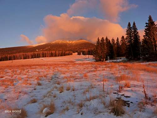
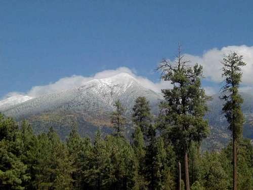
June-October are the best climbing months. It is possible to hike Humphreys in May, but not recommended. There is still a lot of snow and it is very windy. Gusts can be over 50 mph and even be over 80 mph. May is the windiest month in Flagstaff. Any month of the year can be windy on top of Humphreys. September also can bring in strong winds as well.
For hiking in June, expect there to be snow on the trail still. This is probably one of the best months. It's right before the monsoons and should be warm. July-September, you have to deal with the monsoons. Start early and be below tree line before noon. October might have a little snow, and prepare for the cold. It can be very windy and cold this time of year. There should not be enough snow to make it a snow climb in the slightest bit. Most the snow that hits the mountain is gone in a few days. No matter what time of the year, expect it to be windy. Not that it's windy every day of the year, but best to prepare for it. On calm, breezy days, expect there to be lots of bugs on top.
Winter Climbing:
Winter climbing is not unheard of. When it's snow capped there are many ways of doing Humphreys Peak. One of the best and preferred routes is the Dutchman and the West Ridge route. Jhodlof Has posted a really good detailed summery of this route. Snow bowl Road gets closed before the skiing season. It might be due to icy road conditions. For more info to see if the road is open click here
Also to check up on snow conditions go to Arizonasnowbowl.com
Must read if your planning a snow climb
Back country Permits Now Available
Flagstaff, AZ - Kachina Peaks Wilderness Access permits, commonly known as back country permits, are now available at the Peaks and Mormon Lake Ranger Districts. This free permit is designed to help inform back country snow recreationalists about travel hazards, and to assist the Forest Service and the Coconino County Sheriff’s Office with search and rescue should that become necessary. Permits are only required for accessing the back country from Arizona Snow-bowl and the Snow-bowl Road.
Back country permits are valid for the entire winter and are designed for snowshoers, cross-country skiers and snowboarders using the Kachina Peaks Wilderness. Permits are required to be displayed in the front windshield of the permit holder’s vehicle if the vehicle is parked at the Lamar Haines trail-head, the entrance of the Freidlein Prairie Road (Forest Road 522) or the Arizona Snow-bowl Ski Area.
In addition to having a permit, back country campers, skiers and snowboarders who launch their trip from the Ski Area or the Snow-bowl Road also need to enter information in one of three trip registers. The Coconino National Forest added a new trip register location at the Lamar Haines trail head on Snow-bowl Road last year. The others are at the ticket window at the Hart Prairie Lodge and near the top of the Agassiz chairlift.
“We want people to enjoy back country winter activities—but with a high degree of safety,” said Steve Jenner, snow ranger for the Peaks Ranger District. “The information we’re asking for is intended to help people avoid dangers associated with avalanches and hypothermia. When someone reads the hazard warnings on the permit, it usually makes them stop and think for a few moments, and this is often exactly what is needed to introduce the element of caution that can save a person’s life.”
Back country permits, which again are free of charge, are available at the Peaks or the Mormon Lake Ranger Stations during the week. Once the Arizona Snow-bowl opens, permits may also be obtained at the ticket window at the Agassiz Lodge on Saturdays, Sundays and holidays from 10:00 AM until noon. For more information, call the Peaks Ranger Station at (928) 526-0866 or the Mormon Lake Ranger Station at (928) 774-1147
 |
 |
 |
 |
 |
Camping
For the most part, camping is not allowed in the Kachina Peaks Wilderness. Camping is allowed below 11,400 feet, but not allowed near the skiing slopes.
Hart's Prairie
just below San Francisco Mountain is a nice place to camp. From Flagstaff take US 180 past the Snow Bowl Road. Make a right on FR 151 to get to Harts Prairie. This is a very large area with forest roads winding through the area. There are no established campgrounds and no water, not even any creeks. Camping here is free. Some of the roads might require high clearance.
Locket Meadow
Depending on weather, the season runs mid-May–mid-Oct.; there are vault toilets and an $10 fee, $5 per extra vehicle, but no water; you can also use the sites for picnicking 10 a.m.–4 p.m. for $5. Designated day-use parking is free. No reservation, first come first serve.
Mountain Conditions
Coconino National Forest web page Links to Flagstaff and the San Francisco Peaks This page has all the links you need for Flagstaff and "The Peaks" There are quite a few web cams as well. The top of Humphreys is often very windy. It often has wind gusts over 50 mph. Always prepare for both warm and cold, windy conditions. The top is unpredictable. Flagstaff’s 10 day forecast
Geology


Humphreys Peak is the highest point of San Francisco Mountain. San Francisco Mountain is a fragment of what was a much larger mountain. It is estimated that San Francisco Mtn. was once about 16,000-20,000 feet. It is also Arizona's only strato-volcano.
San Francisco Mountain has said to be Mt. Saint Helens twin. Before the eruption of Mt. Saint Helens there was many questions about San Francisco Mtn. Scientist did not know why it had its bowl shape. Volcanoes usually blow up and not to the side. And if it did erupt, what happened to all the matter that was blown away.
It was once assumed that maybe the mountain caved in and created its bowl appearance. That theory was never fully accepted. After Mount Saint Helens erupted a lot of questions were answered. Mount Saint Helens did not blow up, it blew out; and then a lava dome stared to grow inside of it. San Francisco Mtn. has a lava dome just on the outside of it, named Sugarloaf, which formed after it blew. The appearance of both San Francisco Mtn. and Mount Saint Helens is remarkably similar when viewed from looking into both of their bowls.
To see more on the geology and to see pictures of the mountains bowl go to Volcanoworld.com .
 |
 |
 |
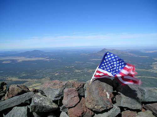
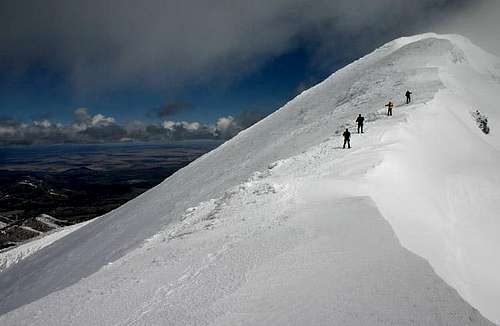
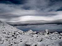
Views from the summit
These pictures are some views from the top of Humphreys Peak
 |
 |
 |
 |
Arizona's 20-20 Challenge
Yes Arizona has it's own little challenge just like other states do like the Colorado/California 14ers, Idaho 12ers, or even doing all the State High points.
Arizona's Challenge is the 20 highest and the 20 deepest.
What this means is the 20 highest mountains that are not on protected areas and has a trail to the summit and the 20 deepest canyons with the same criteria.
The mountains all have an elevation gain of at least 1,000 feet.
For more information go to Arizona's 20-20 Challenge
| Mountain | Canyon |
| Humphryes Peak | Grand Canyon |
| Mount Baldy | Tuckup Canyon |
| Escudilla Peak | Paria Canyon |
| Kendrick Peak | Oak Creek Canyon |
| Webb Peak | Jumpup Canyon |
| Heliograph Peak | KP Canyon |
| Charicahua Peak | Salome Canyon |
| Flys Peak | kanab Canyon |
| Showshed Peak | Secret Canyon |
| Miller Peak | Jacks Canyon |
| Wrightson Peak | Bear Wallow Canyon |
| Monte Vista Peak | W. Clear Canyon |
| Blue Peak | Fossil Springs |
| Mount Elden | Havasu Canyon |
| Bill Williams Mountain | Long Canyon |
| Carr Peak | Hack Canyon |
| Mount Lemmon | West Fork |
| Clark Peak | Sycamore Canyon |
| Sentinal Peak | Wet Beaver Canyon |
| O'Leary Peak | Agua Fria Canyon |
Jeff12633 - Nov 3, 2003 8:31 pm - Hasn't voted
Untitled CommentThere are in fact three trails to the top of Humphreys Peak; in addition to the Humphreys Peak trail and the Weatherford trail, it is also possible (and increasingly popular) to hike to the top from Lockett Meadow. The Inner Basin Trail winds from Lockett Meadow at 8600 feet up into the Inner Basin, where it eventually joins the Weatherford trail at the saddle between Agassiz and Fremont peaks.
Jeff12633 - Nov 3, 2003 8:36 pm - Hasn't voted
Untitled CommentJune and October are the best months to hike Humphreys Peak. Both are generally very warm, clear, and snow-free. July through September is the monsoon season in Arizona, bringing severe thunderstorms, hail, and even sleet to the peaks on almost a daily basis. Summiting is still possible during these months, but it is advisable to be on your way down no later than 10 or 11 in the morning to beat the storms.
Jeff12633 - Nov 22, 2003 10:37 pm - Hasn't voted
Untitled CommentIf you plan to begin a hike or climb of Humphreys from the Snowbowl ski area during the ski season (generally late December through early April), a Wilderness Permit is required. The permit is free, and can be obtained either from the Peaks District ranger's office or from one of the rangers to be found along Snowbowl Road or at the lower ski lodge during business hours. When hiking or climbing with a wilderness permit, you are required to sign in at the register box next to the lift ticket windows at the lower lodge.
Jeff12633 - Dec 28, 2003 12:25 am - Hasn't voted
Untitled CommentI have found the best Winter ascent route to be as follows:
From the lower trailhead, follow the trail roughly 2 miles to the third switchback after the lower trail register. The trail has almost always been tracked by hikers in snowshoes within a few days of a snow, so following the trail this far is rarely a problem. At the third switchback, head directly up the narrow rockfall.
Once you reach the trees, bear left at a 30 degree angle and continue several hundred vertical feet until you come to a large clearing. This is where the famous bomber wreck is located. Head for the upper left corner of the clearing; this is the most direct path to treeline, and puts you close to a long, very easy ridge which leads straight upslope to the trail just below the summit ridge, which it meets at about 12,200 feet.
Turn left and follow the trail and/or the snow atop the summit ridge all the way to the summit; be careful of snow cornices atop the ridge, and be prepared for howling winds anywhere along the ridge.
Upon descending, follow the summit ridge all the way to the Humphreys-Agassiz saddle. Continue traversing onto the slopes below Agassiz until you are directly above the ski slopes, then glissade, sled, or ski down to the slopes and follow them back to the lower lodge. Note: I do not know if the required Wilderness Permit will satisfy the ski patrol if they find you walking or sledding on the ski slopes, so be discreet and be careful!
Steven Cross - Dec 28, 2003 6:16 pm - Hasn't voted
Untitled CommentThis is really good info, but how about putting it in the routes section? Then if you have some photos of it you can post them on your Route page.
splattski - Dec 30, 2003 8:15 am - Voted 10/10
Untitled CommentOn December 28, we attempted to visit Humphreys. The road to the Snowbowl was gated and locked. Talking to a local at a motel on the highway, this is normal when the ski area is not open. He wasn't sure if it was due to snow, or simply always that way after a specific date.
The week previously, I had a phone conversation and discussed permits with the Forest Service, and they told me I would have no problem getting to the Snowbowl. Apparently they are unaware of the policies.
Steven Cross - Dec 30, 2003 7:31 pm - Hasn't voted
Untitled CommentThanks for posting this. I was unaware the road closes sometimes. I don't even recall seeing a gate that can be locked. Where was the gate? At the turnoff or further up the road?
n8jojohnson - Oct 18, 2004 1:06 pm - Hasn't voted
Untitled CommentSince Humphreys is located in a National Forest, you can pretty much camp anywhere, certain restrictions applying, of course.
I was a little concerned I wouldn't find camping near the Weatherford Trail for my alpine start - but there were plenty of small Forest Roads offering plenty of places for dispersed camping. I'm sure the same holds true near the Humphreys trailhead.
Check out this website on rules & regs on dispersed camping:
http://www.fs.fed.us/r3/coconino/recreation/other-rec/dispersed_camping.shtml
smokehound - May 18, 2005 8:05 pm - Hasn't voted
Untitled CommentClimbed the san fransico peaks last week, tuesday and wednesday. Weather was pretty windy on tuesday with about three hours of sleet the size of rock salt. The weather cleared about six o'clock in the evening with clear skies. Got up at about five wednesday morning and hit the snow at about six for my trek to the top. The snow was perfect, consolidated and frozen from the previous night. Made the summit at about eleven in the morning. It was beautiful, not a cloud in the sky and just the normal wind on the ridge line. Had the summit all to myself, there wasn't another climber anywhere on the mountain. In the right weather and snow conditions this makes for a very nice climb in the snow!!
Alpinist - Oct 16, 2005 1:02 am - Voted 10/10
Untitled CommentMoogie737 - Mar 2, 2013 11:51 am - Voted 10/10
Finding the trail from the day-use parking lotOne pretty much heads across the ski run area several hundred yards and then enters the forest at the small trail sign. Ten yards further there is a large wooden sign reading "Kachina Peaks WILDERNESS.". In about 10 to 15 minutes you encounter one of the trail register boxes next to another wooden sign reminding you what the name of the wilderness area is!
bread2u - Apr 2, 2013 9:04 am - Hasn't voted
Arizona's 20-20 ChallengeThe asu.edu address is no longer a valid link. http://www.az2020.org/ is the current address.