
-
 65490 Hits
-
 95.35% Score
-
 52 Votes
|
|
Mountain/Rock |
|---|---|
|
|
45.90810°N / 7.86052°E |
|
|
Valle d'Aosta, Piemonte |
|
|
Mountaineering |
|
|
Spring, Summer |
|
|
13829 ft / 4215 m |
|
|
Overview
Piramide Vincent 4215 m
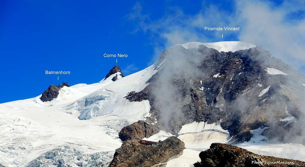
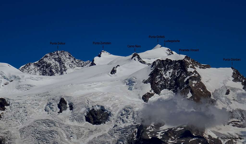
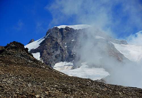
Piramide Vincent 4215 m is a mountain belonging to the Monte Rosa Group, Pennine Alps and located between Punta Giordani and Colle Vincent. It's the Southernmost 4000m peak of the massif and the "home summit" of the Rif. Gnifetti and Rif. Mantova. It's entirely located in Italian territory, shared by the counties of Valle d'Aosta and Piemonte and it's the last peak on the majestic and long ridge starting from Punta Nordend and winding from North to South with a terrific sequence of 4000s: Dufour, Zumstein, Gnifetti, Parrot, Ludwigshöhe, Corno Nero are the other mountains that make up this extraordinary icy and rocky wall. Together with the Western Breithorn, Piramide Vincent is considered as one of the easiest 4000s of the Alps, to be climbed without much difficulty along the Normal route described below. Check here the complete list of the 82 alpine Fourthousanders and the 46 minor summits: Club4000.
As its name says it's a true pyramid with four ridges giving rise to as many sides. It's a very nice summit, often climbed in one day starting from the valley floor, facilitated by the car-lift both from the Valle d'Aosta and Piedmont sides. It is therefore visited by many mountaineers as a not too demanding destination or as training and acclimatization in view of more demanding ascent.


However, this solution could cause acclimatization problems and it is rather advisable to stay overnight in the Refuge Mantova or Gnifetti. The summit panorama is quite remarkable. There are different routes: the SW-flank - S-ridge - S-flank in summer and the shorter NW-flank, also for skimountaineers. Not discutable are the routes (V) through the crumbling and objectively dangerous 500 m high S-face. But there are 3 interesting mixed routes in the 350 m high SW-face (all III+).
History
The first summiter was Johann Nikolaus Vincent from Gressoney, whose name was given to the mountain, along the South-East route, with three companions on 5th August 1819. The NE-ridge was climbed for the first time in 1851 by the brothers Schlagintweit with the guide Peter Beck. It is interesting especially for ski-mountaineers although they normally climb the shorter NW-flank.
Getting There
FROM ITALY - The approach to Piramide Vincent Normal route starts from Punta Indren. Two different approachs ways are possible depending if coming from the Valle di Gressoney (Aosta) or from Val Sesia (Piemonte).
Access via the Valle di Gressoney (Aosta Valley) - From the A5 Torino – Aosta Highway, exit Pont St. Martin and take the Valle di Gressoney, getting to Gressoney St. Jean, Gressoney La Trinité and Staffal. From Staffal take the Cable car to Alpe Gabiet – Passo dei Salati - Indren
Access via the Val Sesia (Piemonte) - From the A26 Highway exit to Romagnano Sesia and take the road to Varallo Sesia. Here continue following all the Val Sesia road to Alagna Valsesia. From Alagna Valsesia take the Cable car to Pianalunga - Passo dei Salati – Indren
FROM SWITZERLAND - You reach Alagna by car on the road no. E62 from Brig via Simplonpass. Turn off at Ornavasso (near the Lago Maggiore) and drive to Omegna. Take the road along the western shore of the Lago d'Orta over the Colma pass to Varallo and continue to Alagna. You can reach Aosta through the Great St.Bernard Tunnel or the Great St.Bernard Col, then follow the road running in Val Gressoney to Staffal
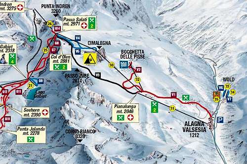
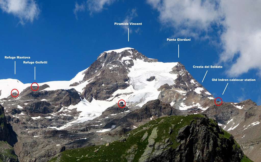
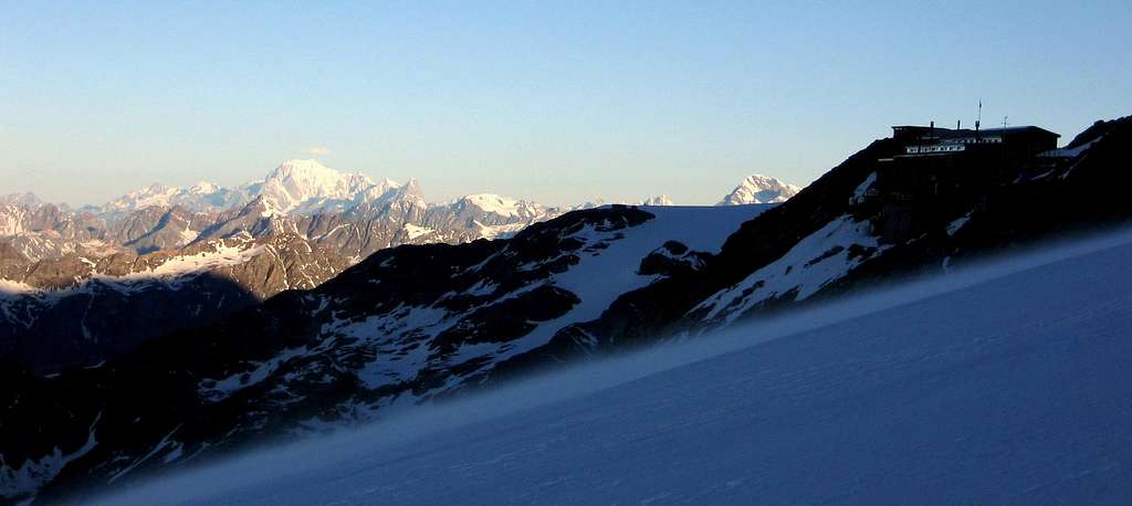
Access to the Rif. Gnifetti 3611 m and Rif. Città di Mantova 3498 m: from Punta Indren, 3260 m (cable car from Alagna or Gressoney) you reach first the Rif. Città di Mantova in 1 hour, then the Ref. Gnifetti in 1,30 hour. In the lower part, it is a marked path (no. 5). The traverse of the glacier is not marked. From Punta Indren, traverse the ski-run, slowly going up on the Indrenglacier till you reach the outstanding rock band above which the Mantova-hut is situated (yellow-red signs). You climb up the rock steps (fixed ropes). From the hut, you go up over the E-side of the Lysglacier to the N and at the end over rocks to the Gnifetti hut.
Alternatively by walk (no cable car) 7 h from Alagna
Can get to Punta Indren on the marked hiking path n. 5 from Alagna via Dosso (1357m). You go to the Alpe Oltu (1847m, cable car station, 1,5 h) and furth up the Valle d'Olen. You go along the Sasso del Diavolo and reach almost Colle d'Olen, where you turn right to the Vigevano-hut (3 h). You go further along Passo Salati (2936m) to the ridge-crest and traverse Stolemberg. Over the side of the Indrenglacier, you reach the station (1 1/4 h, totally 6 h).
Approach to Rifugio Mantova and Rifugio Gnifetti
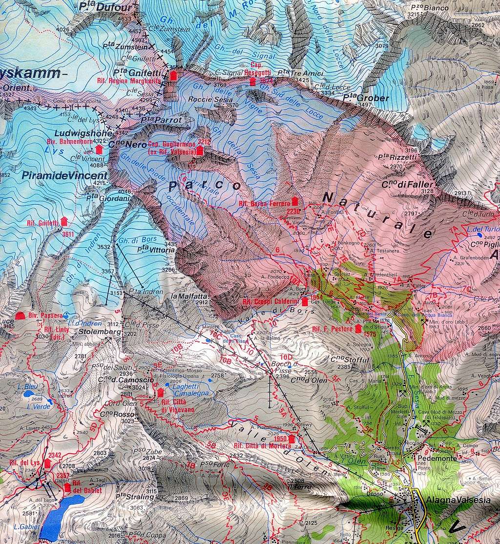
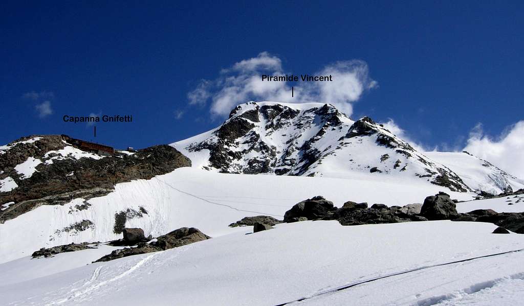
Approach to Refuge Mantova 3470 m and Capanna Gnifetti 3611 m
The Rifugio Mantova is located at the foot of the Garstelet Glacier, just below the Capanna Gnifetti. Both huts are the starting point for the ascent to Piramide Vincent and to some other peaks of the Monte Rosa Group, such as Punta Gnifetti, Corno Nero, Eastern Lyskamm. You pass the cable car station leaving it to the right and head towards the small Indren glacier to cross it completely. In this section it is not normally necessary to use the crampons as there are no strong slopes and the track is normally obvious. In addition, snowfall is reduced year by year. In any case, it is appropriate to evaluate according to the season and the conditions. Crossing the glacier, or what remains of it, you reach the base of a rocky wall, here you can alternatively follow two trails: the high one that with small bends leads to the small rocky wall, where the path is equipped with fixed ropes and ladders, or follow a low trail that goes beyond the glacier and runs on the more gentle side of the wall reaching the Rifugio Mantova trail. Using the high track, it shortens the route for about 15 minutes. From here you can see both Rifugio Mantova and Rifugio Gnifetti. With a slight descent to the left you reach the Rifugio Mantova, while crossing the area of stones and rocks you enter the glacier of the Garstelet and following the obvious track to the Rifugio Gnifetti.
Route: North-West side (Normal route)
Piramide Vincent North-West side (Normal route)
Difficulty: F (Alpine scale)
Difference in level: 600 m from Capanna Gnifetti - 750 m from Rifugio Mantova
An interesting route, following at first a great glacier – the Lys Glacier - then the gentle NW slopes of the peak. The ascent is easy, but involving a full glacier's equipment. Lys Glacier has several crevasses - often hidden in early summer - so it is necessary to cross it by proceeding enroped.


From the shelters – Rifugio Mantova or Capanna Gnifetti – gain the starting point of the Lys Glacier, which begins nearby Capanna Gnifetti. Enter the glacier and follow it at first diagonally to the left (toward North-East) along a steep ramp, then toward North rising on moderate ice-slopes, never too away from the steep slopes of Vincent. In some sections the route presents a few passages between wide crevasses. Continue always along the track, usually present in summer, heading to the Lys Col.
After passing a series of irregular slopes, the itinerary gets the snowy basin below the Balmenhorn at about 4000 m. and almost under the rock of Balmenhorn it leaves on the left the main track directed towards the Lys Col and bends sharply to the right along a moderate slope in the direction of Colle Vincent. Shortly before reaching it, it turns to right again to the right and climb the wide NW snow slope of Vincent, not difficult and normally well traced. Only in the final meters the slope slightly increases, giving access to the top.
Descent: along the same itinerary
 seen from the west")


Route: SSW ridge
Piramide Vincent - Photo Antonio Giani
SSW ridge report
Difficulty: PD (Alpine scale)
Difference in level: 600 m from Capanna Gnifetti - 750 m from Rifugio Mantova
Departure location: new cableway Indren (Alagna Valsesia, VC)
Huts: Rifugi Mantova and Gnifetti
Mixed ascent, first climb C. Perazzi and P. Maquignaz, 22/07/1882
From the Mantova or Gnifetti huts crosses the glacier of Garstelet, getting the wide ridge of shrubs and rocks. Follow it up to the top, alternating snow slopes and easy climbing on steps and rocks. The difficulties are always contained (max. Grade II UIAA) and the most demanding traits are avoidable on the SE side near the ridge. Various escape routes are possible on both the Garstelet and Bors slopes, and the best is approximately 3900 m when the ridge extends into a wide snowy saddle. Hence, with a large semicircle on the southeast Vincent slope, it is possible to easily reach the top of Punta Giordani.
Route: ESE ridge
Piramide Vincent ESE ridge
Difficulty: PD (Alpine scale)
Difference in level: 950 m from Indren
Very nice and spectacular itinerary, starting from Indren cableway station, involving the ascent to Punta Giordani, then continuing on the ridge - sometimes airy - of Piramide Vincent
Once you reach the summity of Punta Giordani m 4046, via the Normal Route or the Cresta del Soldato, follow the watershed ridge paying attention to the corniches on the North side and bypassing to the left a rocky islet protruding above a saddle, follow the ESE ridge of the Pyramid Vincent, which after a snowy and flat stretch rises with rocky outcrops to get the summit.
Descent - on the Normal route
Other routes
SW-flank/-ridge : Several routes on shoulders, spurs and couloirs III and IV, 4-6 hours from the Gnifetti hut
NE-flank (N-spur): Start from the Alagna side (Valsesia hut 3312 m). Rock climb, IV, 6 hours from the hut
When to climb
Mountaineering: best months are June, July, August and September
Ski-mountaineering: from the end of March to the end of May
Huts
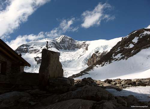
Lyskamm seen from Rif. Mantova
- Rifugio Città di Mantova m. 3470
Situation: Garstelet Glacier
Open: from June to September
Size: 85 persons + 15 in the winter-shelter
Guardian: Guide di Gressoney
Hut's phone : 0039 0163 78150 / 347 0802910
Email: info@rifugiomantova.it
Situation: rockspur between the Lysglacier and the Garsteletglacier
Open: spring from middle March to middle May - summer from middle June to middle September
Size: 176 persons + 4 in the winter-shelter
Hut's phone : 0163 78150 / 347 0802910
Email: info@rifugimonterosa.it
Meteo
Meteo Regione Valle d'Aosta
Meteo Piemonte
Guidebooks and Maps
|
 |
 |
 |
 |
 |
Guidebooks
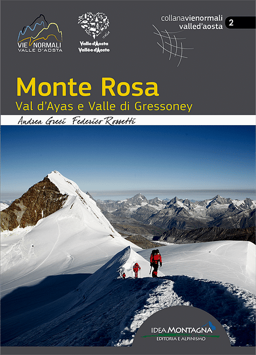
"Monte Rosa - Val d'Ayas e Valle di Gressoney" by Andrea Greci, Federico Rossetti - Idea Montagna ed. 2020
"Il grande libro dei 4000 - Vie normali e classiche" by Marco Romelli, Valentino Cividini - Idea Montagna Editore, 2015
“Tutti i 4000 – L’aria sottile dell’alta quota” – Club 4000, CAI Torino – Vivalda Editori
“4000 delle Alpi” by Richard Goedeke - Ed. Libris
“Monte Rosa” by Gino Buscaini - Guida dei Monti d'Italia C.A.I.-T.C.I.
"Guide des Alpes Valaisannes" Vol. 4 (in French or German)
Italian Maps
"Breuil/Cervinia-Zermatt" Kompass map 1:50.000.
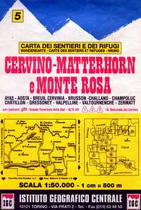
"Cervino-Matterhorn e Monte Rosa" n. 5 - Istituto Geografico Centrale map 1:50.000
"Monte Rosa, Alagna e Macugnaga" n. 10 Istituto Geografico Centrale, Torino 1:50000
Swiss Maps
"Matterhorn-Mischabel" n. 5006 1:50000 (only valuable if access from north)
"Gressoney" n. 294 1:50000 (shows all the Italian part)
Literature
"The High Mountains of the Alps" - Dumler/Willi P. Burkhardt, 1994. (to order at amazon.com) ISBN 0898863783
"Viertausender der Alpen" 11th ed. Munich 1998 Dumler/Willi P. Burkhardt, ISBN 3-7633-7427-2
"Walliser Alpen" DAV-Gebietsführer. 12th ed. Munich 1999 Michael Waeber, . ISBN 3-7633-2416-X
"Walliser Alpen - Die 100 schönsten Touren" 2nd ed. Munich 1990, Michel Vaucher ISBN 3-7654-2124-3
External Links
Piramide Vincent at www.4000er.de Images, routes, coordinates and more information about the highest peaks of the Alps Ludwigshöhe, Parrotspitze, etc Climbing in the Southern Monte Rosa Group